|
Philip's Maps
Philip's Junior School Atlas 10th Edition
2019-06-13. New. Ships with Tracking Number! INTERNATIONAL WORLDWIDE Shipping available. May be re-issue. Buy with confidence excellent customer service! unknown
Bookseller reference : 1849074941n ISBN : 1849074941 9781849074940

|
|
|
Philip's Maps
Philip's Junior School Atlas 10th Edition
2019-06-13. Good. Ships with Tracking Number! INTERNATIONAL WORLDWIDE Shipping available. May not contain Access Codes or Supplements. May be re-issue. May be ex-library. Shipping & Handling by region. Buy with confidence excellent customer service! unknown
Bookseller reference : 1849074941 ISBN : 1849074941 9781849074940

|
|
|
Philip's Maps
Philip's Modern School Atlas 99th Edition
Paperback / softback. New. As essential reference work for secondary education 14-18 year-olds suitable for Key Stage 4 GCSE A-Level and international schools paperback
Bookseller reference : A9781849074933 ISBN : 1849074933 9781849074933

|
|
|
Philip's Maps
Philip's Modern School Atlas 99th Edition
Hardback. New. An essential reference work for secondary education 14-18 year olds suitable for Key Stage 4 GCSE A-Level and international schools. hardcover
Bookseller reference : A9781849074926 ISBN : 1849074925 9781849074926

|
|
|
Philip's Maps
Philip's Modern School Atlas 99th Edition
Philip's. Used - Like New. Ships from the UK. Book in almost Brand New condition. 100% Money Back Guarantee. Your purchase also supports literacy charities. Philip's unknown
Bookseller reference : GRP113775715 ISBN : 1849074933 9781849074933
|
|
|
Philip's Maps
Philip's Multiscale Europe 2020 A4: A4 Spiral binding Philips Road Atlas
2019-04-04. Good. Ships with Tracking Number! INTERNATIONAL WORLDWIDE Shipping available. May not contain Access Codes or Supplements. May be re-issue. May be ex-library. Shipping & Handling by region. Buy with confidence excellent customer service! unknown
Bookseller reference : 1849074992 ISBN : 1849074992 9781849074995

|
|
|
Philip's Maps
Philip's Multiscale Europe 2020 A4: A4 Spiral binding Philips Road Atlas
2019-04-04. New. Ships with Tracking Number! INTERNATIONAL WORLDWIDE Shipping available. May be re-issue. Buy with confidence excellent customer service! unknown
Bookseller reference : 1849074992n ISBN : 1849074992 9781849074995

|
|
|
Philip's Maps
Philip's Outer Hebrides: Leisure and Tourist Map 2020 Philip's Red Books
2019-05-02. New. Ships with Tracking Number! INTERNATIONAL WORLDWIDE Shipping available. May be re-issue. Buy with confidence excellent customer service! unknown
Bookseller reference : 184907514Xn ISBN : 184907514x 9781849075145

|
|
|
Philip's Maps
Philip's Orkney and Shetland: Leisure and Tourist Map 2020: Leisure and Tourist Map
Paperback / softback. New. A leisure and tourist map of Orkney and Shetland with places of interest clearly marked. Detailed coverage of the islands' road network. Easy-to-read road mapping ideal for journey route-planning. Great value for money at only GBP5.99 paperback
Bookseller reference : A9781849075138 ISBN : 1849075131 9781849075138

|
|
|
Philip's Maps
Philip's Outer Hebrides: Leisure and Tourist Map 2020: Leisure and Tourist Map
Paperback / softback. New. A new edition of this single-sided folded sheet map of the Outer Hebrides giving detailed coverage of the area's road network and featuring places of tourist and historic interest. paperback
Bookseller reference : A9781849075145 ISBN : 184907514x 9781849075145

|
|
|
Philip's Maps
Philip's Road Map France and Belgium
2018-05-03. New. Ships with Tracking Number! INTERNATIONAL WORLDWIDE Shipping available. May be re-issue. Buy with confidence excellent customer service! unknown
Bookseller reference : 1849074372n ISBN : 1849074372 9781849074377

|
|
|
Philip's Maps
Philip's Road Map France and Belgium
Paperback / softback. New. A fully revised new edition of Philip's ultra-clear double-sided road map covering the whole of France and Belgium with a comprehensive index and seven town plans. paperback
Bookseller reference : A9781849074377 ISBN : 1849074372 9781849074377

|
|
|
Philip's Maps
Philip's Road Map France and Belgium
Philip's. Used - Like New. Ships from the UK. Book in almost Brand New condition. 100% Money Back Guarantee. Your purchase also supports literacy charities. Philip's unknown
Bookseller reference : GRP114988512 ISBN : 1849074372 9781849074377
|
|
|
Philip's Maps
Philip's Red Books Skye and Lochalsh: Leisure and Tourist Map
2014-06-02. Good. Ships with Tracking Number! INTERNATIONAL WORLDWIDE Shipping available. May not contain Access Codes or Supplements. May be re-issue. May be ex-library. Shipping & Handling by region. Buy with confidence excellent customer service! unknown
Bookseller reference : 1849073244 ISBN : 1849073244 9781849073240

|
|
|
Philip's Maps
Philip's Skye and Lochalsh: Leisure and Tourist Map 2020 Philip's Red Books
2019-05-02. New. Ships with Tracking Number! INTERNATIONAL WORLDWIDE Shipping available. May be re-issue. Buy with confidence excellent customer service! unknown
Bookseller reference : 1849075158n ISBN : 1849075158 9781849075152

|
|
|
Philip's Maps
Philip's Spain and Portugal Road Map
Paperback / softback. New. A fully-updated edition of Philip's double-sided folded sheet map covering the whole of Spain and Portugal including the Balearic Islands at 16 miles to 1 inch 1 cm on the map = 10 km on the ground. paperback
Bookseller reference : A9781849074391 ISBN : 1849074399 9781849074391

|
|
|
Philip's Maps
Philip's Skye and Lochalsh: Leisure and Tourist Map 2020: Leisure and Tourist Map
Paperback / softback. New. A new edition of this single-sided folded sheet map of Skye and Lochalsh giving detailed coverage of the area's road network and featuring places of tourist and historic interest. paperback
Bookseller reference : A9781849075152 ISBN : 1849075158 9781849075152

|
|
|
Philip's Maps
Philip's Scotland Road Map
Paperback / softback. New. A fully revised new edition of Philip's ultra-clear road map covering the whole of Scotland with town-centre plans for Aberdeen Dundee Edinburgh and Glasgow. paperback
Bookseller reference : A9781849074469 ISBN : 1849074461 9781849074469

|
|
|
Philip's Maps
Philip's Street Atlas Derbyshire
Spiral bound. New. A fully updated edition of this spiral-bound Philip's street atlas of Derbyshire giving detailed coverage of the region. The atlas is suitable for both business and leisure use. unknown
Bookseller reference : A9781849074292 ISBN : 1849074291 9781849074292

|
|
|
Philip's Maps
Philip's Street Atlas Norfolk
Spiral bound. New. A fully updated edition of this spiral-bound Philip's street atlas of Norfolk giving detailed coverage of the region. The atlas is suitable for both business and leisure use. unknown
Bookseller reference : A9781849074285 ISBN : 1849074283 9781849074285

|
|
|
Philip's Maps
Philip's The Cotswolds: Leisure and Tourist Map
Paperback / softback. New. A new edition of this double-sided map of the Cotswolds. Featuring places of tourist and historic interest in an easy-to-read style of mapping. 6 town centre plans. paperback
Bookseller reference : A9781849075381 ISBN : 1849075387 9781849075381

|
|
|
Philip's Maps
Philip's World Atlas: Paperback
Paperback / softback. New. An information-packed paperback world atlas from Philip's published in association with the Royal Geographical Society - fully revised and updated. paperback
Bookseller reference : A9781849075169 ISBN : 1849075166 9781849075169

|
|
|
Philip's Maps
Philip's World Atlas
2016-02-04. Good. Ships with Tracking Number! INTERNATIONAL WORLDWIDE Shipping available. May not contain Access Codes or Supplements. May be re-issue. May be ex-library. Shipping & Handling by region. Buy with confidence excellent customer service! unknown
Bookseller reference : 1849073937 ISBN : 1849073937 9781849073936

|
|
|
Philip's Maps and Atlases
Road Atlas: France Belgium Luxembourg
Philip's. Spiral-bound. Used; Good. Simply Brit Shipped with Premium postal service within 24 hours from the UK with impressive delivery time. We have dispatched from our book depository; items of good condition to over ten million satisfied customers worldwide. We are committed to providing you with reliable and efficient service at all times. 02/14/2006 Philip's unknown
Bookseller reference : mon0001566037 ISBN : 0540089540 9780540089543
|
|
|
Philip's Series of Travelling Maps
North America
London UK: George Philip & Son Ltd. Good. 0. Hardcover. Dark blue cloth boards with gilt title. Map folds out to 22 x 28 inches. No date circa 1900s. Boards worn on edges corners bumped spine starting to split.; Book; 12mo - over 6� - 7�" tall . George Philip & Son, Ltd. hardcover
Bookseller reference : 006893

|
|
|
Philip's Series of Travelling Maps
North America
London UK: George Philip & Son Ltd. Good. 0. Hardcover. Dark blue cloth boards with gilt title. Map folds out to 22 x 28 inches. No date circa 1900s. Boards worn on edges corners bumped spine starting to split.; Book; 12mo - over 6¾ - 7¾" tall . George Philip & Son, Ltd. hardcover books
Bookseller reference : 006893
|
|
|
PHILIP, George & Son
Philips' Mercantile Map of Europe
4to [29 x 25 cm, 11.5 x 9.7 inches]; large folding colored map measuring 78 x 122 cm or 37.5 x 48 inches that folds to 29 x 25 cm. original cloth covers, title lettering on cover and spine, joint cracked but firm, marbled endpapers, original ribbon ties, map near fine and clean, linen-backed sectional map as originally issued, in very good original cover. A picture of this book is av A very detailed map, showing all of Europe including Western Russia to Iceland, part of north Africa, Lebanon, most of Caspian Sea. It shows cities, railways, mail and other steamers routes, wireless stations, canals, Lloyd's signal states, each country is shown in different color, also shows altitudes, etc. The scale is 72 mile to the inch or 1:4,500,000.
|
|
|
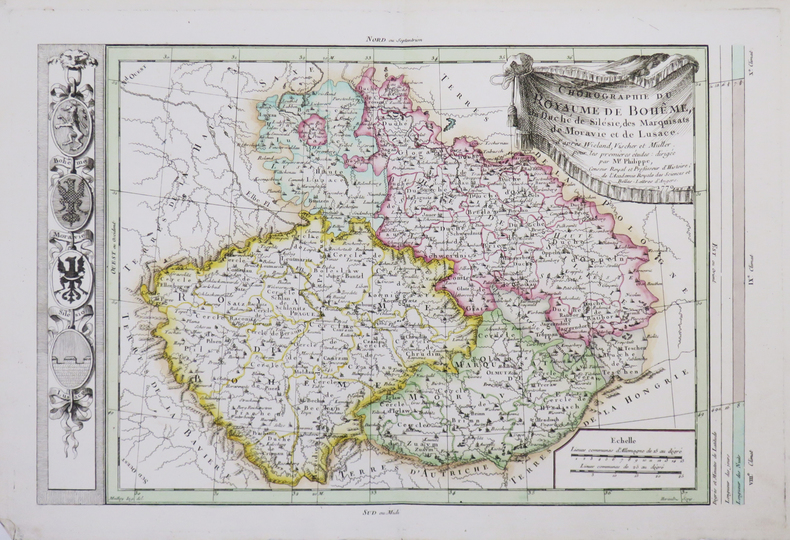
PHILIPPE de PRETOT (Etienne-André).
[BOHÊME] Chorographie du royaume de Bohême, du duché de Silésie, des marquisats de Moravie et de Lusace.
1770. 266 x 400 mm.
Bookseller reference : LBW-4662
|
|
|
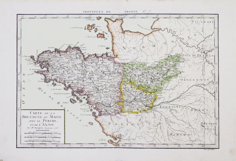
PHILIPPE de PRETOT (Etienne-André).
[BRETAGNE] Carte de la Bretagne, du Maine, avec le Perche, et de l'Anjou.
1763. 255 x 378 mm.
Bookseller reference : LBW-4660
|
|
|
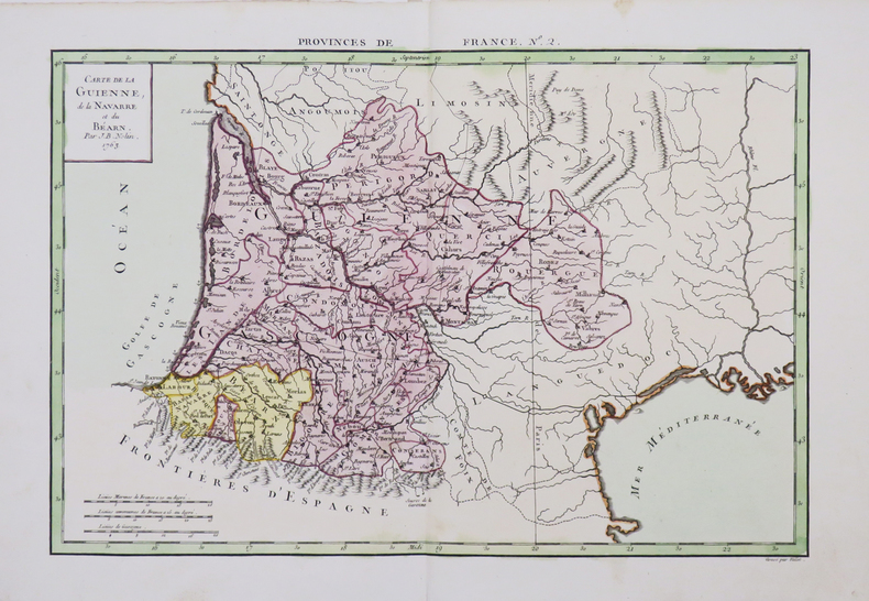
PHILIPPE de PRETOT (Etienne-André).
[GUYENNE/PAYS BASQUE] Carte de la Guienne, de la Navarre et du Béarn.
1763. 258 x 380 mm.
Bookseller reference : LBW-4656
|
|
|
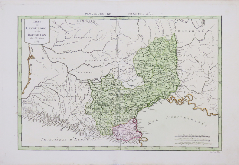
PHILIPPE de PRETOT (Etienne-André).
[LANGUEDOC-ROUSSILLON] Carte du Languedoc et du Roussillon.
1763. 253 x 378 mm.
Bookseller reference : LBW-4655
|
|
|
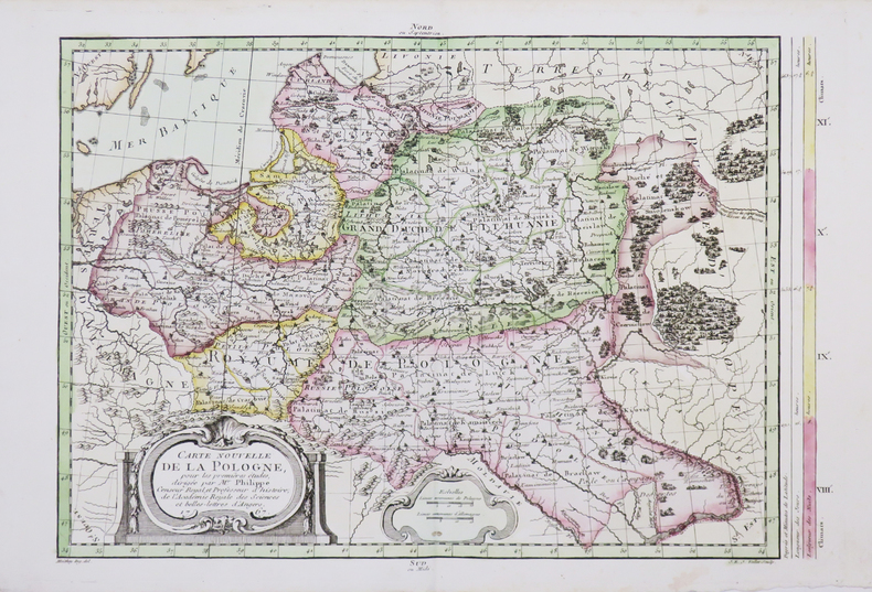
PHILIPPE de PRETOT (Etienne-André).
[POLOGNE] Carte nouvelle de la Pologne.
1767. 281 x 399 mm.
Bookseller reference : LBW-4663
|
|
|
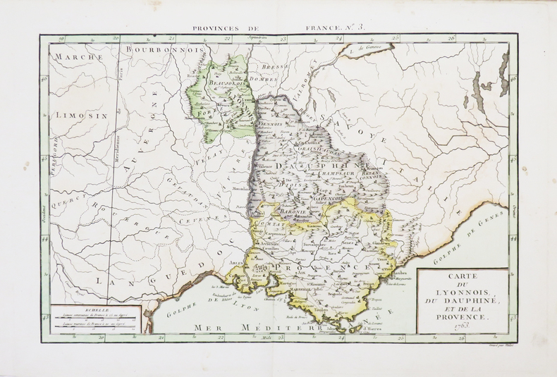
PHILIPPE de PRETOT (Etienne-André).
[PROVENCE] Carte du Lyonnois, du Dauphiné, et de la Provence.
1763. 250 x 375 mm.
Bookseller reference : LBW-4657
|
|
|
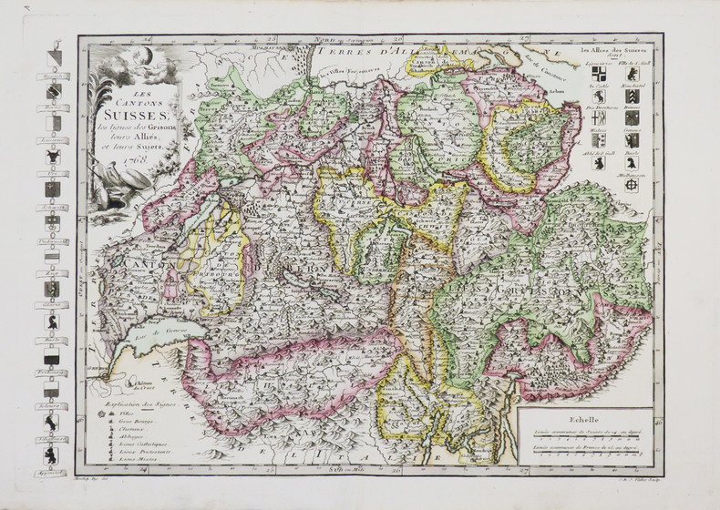
PHILIPPE de PRETOT (Etienne-André).
[SUISSE] Les Cantons suisses, les ligues des Grisons, leurs alliés, et leurs sujets.
1768. 264 x 372 mm.
Bookseller reference : LBW-4661
|
|
|
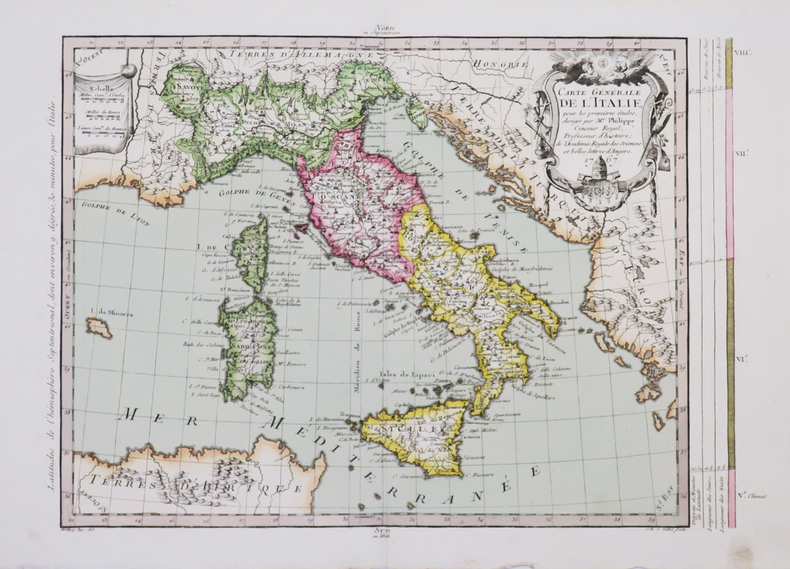
PHILIPPE de PRETOT (Etienne-André).
Carte générale de l'Italie.
1767. 275 x 375 mm.
Bookseller reference : LBW-4665
|
|
|
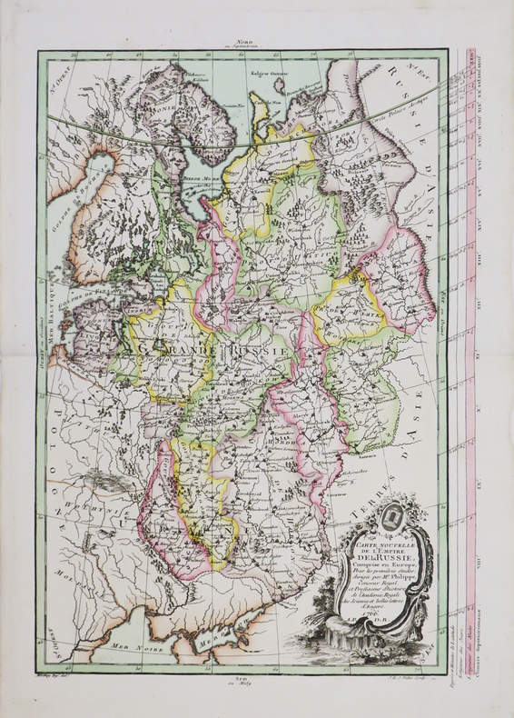
PHILIPPE de PRETOT (Etienne-André).
Carte nouvelle de l'empire de la Russie.
1766. 385 x 264 mm.
Bookseller reference : LBW-4654
|
|
|
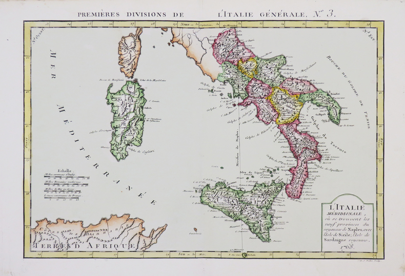
PHILIPPE de PRETOT (Etienne-André).
L'Italie méridionale, où se trouvent les neuf provinces du royaume de Naples, avec l'isle de Sicile, l'isle de Sardaigne royaume.
1768. 251 x 366 mm.
Bookseller reference : LBW-4666
|
|
|
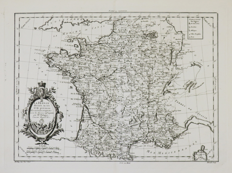
PHILIPPE de PRETOT (Etienne-André).
La France divisée en ses XVIII provinces ecclésiastiques avec les diocèses suffragants.
[circa 1770]. 276 x 372 mm.
Bookseller reference : LBW-4940
|
|
|
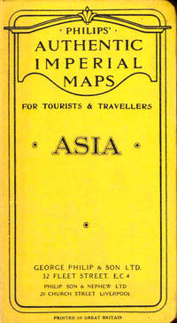
Philips Authentic Imperial Maps
Philips Authentic Imperial Maps For Tourists and Travelers: Asia
Liverpool: George Philip and Son nd. Hardcover. Very good. Boards rubbed and darkened cloth backing slightly tanned else very good. <br/><br/> George Philip and Son hardcover books
Bookseller reference : 43520
|
|
|
Philips Maps
Philips 2018 Motorists Road Atlas Britain and Ireland A3: Large-format paperback Philips Road Atlas
Philips 06/01/2017. Paperback. Used; Good. WE SHIP WITHIN 24 HRS FROM LONDON UK 98% OF OUR ORDERS ARE RECEIVED WITHIN 7-10 DAYS. We believe you will be completely satisfied with our quick and reliable service. All orders are dispatched as swiftly as possible! Buy with confidence! Philips paperback
Bookseller reference : 3765431 ISBN : 1849074607 9781849074605
|
|
|
Philips Maps
Philips 2018 Complete Road Atlas Europe: A4 with practical flexi cover Philips Road Atlas
Philips 04/06/2017. Flexibound. Used; Good. WE SHIP WITHIN 24 HRS FROM LONDON UK 98% OF OUR ORDERS ARE RECEIVED WITHIN 7-10 DAYS. We believe you will be completely satisfied with our quick and reliable service. All orders are dispatched as swiftly as possible! Buy with confidence! Philips unknown
Bookseller reference : 3725227 ISBN : 1849074232 9781849074230
|
|
|
Philips Maps
Philips 2018 Complete Road Atlas Britain and Ireland - Spiral: Spiral binding Philips Road Atlas
Philips. Spiral-bound. Used; Good. Simply Brit Shipped with Premium postal service within 24 hours from the UK with impressive delivery time. We have dispatched from our book depository; items of good condition to over ten million satisfied customers worldwide. We are committed to providing you with reliable and efficient service at all times. 06/01/2017 Philips unknown
Bookseller reference : 2976097 ISBN : 1849074577 9781849074575
|
|
|
Philips Maps
Philips Concise Atlas Britain: Spiral A5 Philips Road Atlas
Philips 03/07/2019. Paperback. Used; Good. WE SHIP WITHIN 24 HRS FROM LONDON UK 98% OF OUR ORDERS ARE RECEIVED WITHIN 7-10 DAYS. We believe you will be completely satisfied with our quick and reliable service. All orders are dispatched as swiftly as possible! Buy with confidence! Philips paperback
Bookseller reference : 3679754 ISBN : 1849075077 9781849075077
|
|
|
Philips Maps
Philips Drivers Atlas Britain: Paperback Road Atlas
Philips 10/06/2016. UK ed. Paperback. Used; Good. WE SHIP WITHIN 24 HRS FROM LONDON UK 98% OF OUR ORDERS ARE RECEIVED WITHIN 7-10 DAYS. We believe you will be completely satisfied with our quick and reliable service. All orders are dispatched as swiftly as possible! Buy with confidence! Philips paperback
Bookseller reference : 3234165 ISBN : 1849074186 9781849074186
|
|
|
Philips Maps
Philips Essential Road Atlas Britain and Ireland 2017: Spiral
Philips. Spiral-bound. Used; Good. Simply Brit Shipped with Premium postal service within 24 hours from the UK with impressive delivery time. We have dispatched from our book depository; items of good condition to over ten million satisfied customers worldwide. We are committed to providing you with reliable and efficient service at all times. 06/23/2016 Philips unknown
Bookseller reference : 2558563 ISBN : 1849074143 9781849074148
|
|
|
Philips Maps
Philips Europe Road Map Philips Road Maps
Philips 05/03/2018. Paperback. Used; Good. WE SHIP WITHIN 24 HRS FROM LONDON UK 98% OF OUR ORDERS ARE RECEIVED WITHIN 7-10 DAYS. We believe you will be completely satisfied with our quick and reliable service. All orders are dispatched as swiftly as possible! Buy with confidence! Philips paperback
Bookseller reference : 3626615 ISBN : 1849074356 9781849074353
|
|
|
Philips Maps
Philips Ireland Road Map
Philips 03/02/2015. Paperback. Used; Good. WE SHIP WITHIN 24 HRS FROM LONDON UK 98% OF OUR ORDERS ARE RECEIVED WITHIN 7-10 DAYS. We believe you will be completely satisfied with our quick and reliable service. All orders are dispatched as swiftly as possible! Buy with confidence! Philips paperback
Bookseller reference : 3549954 ISBN : 1849073597 9781849073592
|
|
|
Philips Maps
Philips Street Atlas Surrey: Spiral Edition
Philips 09/03/2015. Paperback. Used; Good. WE SHIP WITHIN 24 HRS FROM LONDON UK 98% OF OUR ORDERS ARE RECEIVED WITHIN 7-10 DAYS. We believe you will be completely satisfied with our quick and reliable service. All orders are dispatched as swiftly as possible! Buy with confidence! Philips paperback
Bookseller reference : 3761857 ISBN : 1849073694 9781849073691

|
|
|
Philips Maps
Philips Street Atlas Derbyshire: Spiral Edition
Philips. Paperback. Used; Good. Simply Brit Shipped with Premium postal service within 24 hours from the UK with impressive delivery time. We have dispatched from our book depository; items of good condition to over ten million satisfied customers worldwide. We are committed to providing you with reliable and efficient service at all times. 11/03/2016 Philips paperback
Bookseller reference : 3017903 ISBN : 1849074291 9781849074292
|
|
|
Philips Maps
Philips Start Chart 2014 Philips Star Chart
Philips. UK ed. Paperback. Used; Good. Simply Brit Shipped with Premium postal service within 24 hours from the UK with impressive delivery time. We have dispatched from our book depository; items of good condition to over ten million satisfied customers worldwide. We are committed to providing you with reliable and efficient service at all times. 09/01/2014 Philips paperback
Bookseller reference : 2970726 ISBN : 1849073295 9781849073295
|
|
 Receive by email
 Download as PDF document
 RSS feed


