|
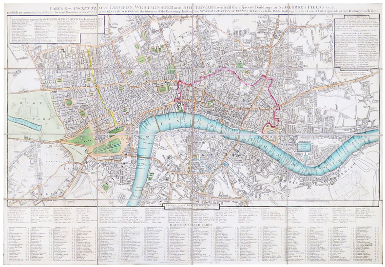
CARY (John).
[LONDRES] Cary's new pocket plan of London, Westminster and Southwark; with all the adjacent buildings in St. George's Fields &c &c.
London, J. Cary, 1819. En 16 sections montées sur toile et pliées, formant un plan de 420 x 613 mm.
Bookseller reference : LBW-5395
|
|
|
CARNEVALE-MAUZAN Mirande
Achille Mauzan. 1883-1952. L'oeuvre Complet (Catalogue raisonné).
2001 Fort in-4 Cartonnage et étui illustrés de l'éditeur
Bookseller reference : 009577
|
|
|
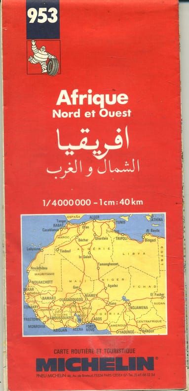
CARTE MICHELIN
Afrique Nord et Ouest.
Bookseller reference : 143307
|
|
|
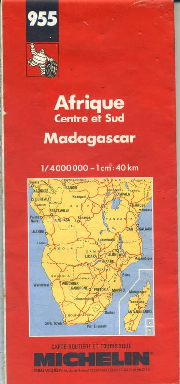
CARTE MICHELIN
Afrique Centre et Sud. Madagascar.
Bookseller reference : 143308
|
|
|
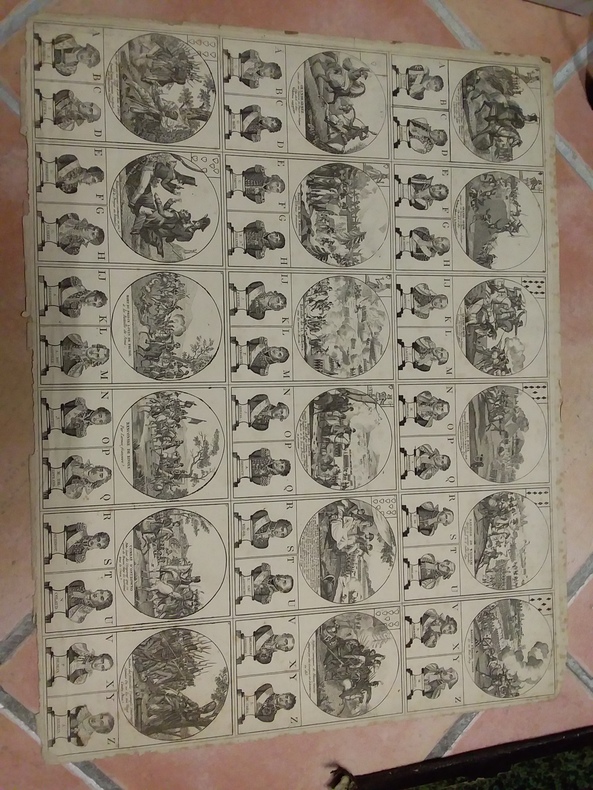
CARTES À JOUER
Arrest du Conseil d'État du Roi, qui ordonne, à commencer du 1er Octobre 1769, l'augmentation du prix marchand du papier Pot filigrané, fourni par le régisseur du droit sur les cartes, aux cartiers du royaume,en exécution de l'Arrêt du 9 Novembre 1751. Du 28 Juillet 1769
Paris P.G. Simon 1769 in-4 en feuilles
Bookseller reference : 2174
|
|
|
CARTES À JOUER
Arrest du Conseil d'Etat du Roi, concernant la forme de l'établissement & de la perception, dans la Principauté de Dombes, du droit y établi sur les cartes à jouer, au profit de l'Ecole Royale militaire, par les lettres patentes du 6 septembre 1772. Du 20 février 1773
Paris P.-G. Simon 1773 in-4 en feuille
Bookseller reference : 33051
|
|
|
CARTES À JOUER
Arrest du Conseil d'Etat du Roi, qui ordonne que sans s'arrêter ni avoir égard à l'arrêt du Parlement de Rouen du 19 mars 1770, le règlement du 9 novembre 1751 concernant la perception du droit sur les cartes à jouer, ensemble les arrêts du Conseil des 23 janvier 1751 & 15 octobre 1757, portant attribution aux sieurs commissaires du bureau des Oblats & aux sieurs intendans dans les provinces, de la connoissance des contraventions concernant ledit droit, seront exécutés selon leur forme & teneur &c. Du 21 avril 1770
Paris P.-G. Simon 1775 in-4 en feuille
Bookseller reference : 33052
|
|
|
CARTES À JOUER
Arrêté du Directoire exécutif, concernant la fabrication des cartes à jouer. Du 21 vendémiaire, an VII de la République française, une et indivisible [12 octobre 1798]
Saintes Imprimerie de Corinthe, Josserand et Hus s.d. [1798] placard in-folio (47 x 38 cm) en feuille
Bookseller reference : 35467
|
|
|
Carte postale ancienne
Artilleur boer avec son canon fabriqué par lui-même - Een boer met zijn door hem zelf vervaardigd
Petite illustration avec texte en français et en Néerlandais, écriture autour, verso timbré et tamponné | Etat : Très bon état général (Ref.: JCP14)
Bookseller reference : 4396
|
|
|
Carte postale
AU BON MARCHE - Maison A. Boucicaut - Paris. Nouveaux magasins - in térieur du hall.
Paris, imp. Henon, 1930, 1 carte postale de 9 x 14 cm, adressée à Madame Charles Forot, Le Pigeonnier, Saint Félicien, Ardèche.
Bookseller reference : 12986
|
|
|
CARDOZE Edmond
BORDEAUX RETRO. LE PATRIMOINE BORDEALAIS EN 202 CARTES POSTALES
Editions librairie Pasteur. 1981. In-8. Broché. Etat d'usage, Couv. légèrement passée, Dos satisfaisant, Intérieur frais. 112 pages, 202 illustrations noir et blanc. . . . Classification Dewey : 741.68-Illustrations des cartes postales
Bookseller reference : RO20065421
|
|
|
CARUELLE d'ALIGNY (Théodore).
Campagne de Rome. Vue prise sur l'ancienne voie des tombeaux.
1844. 267 x 382 mm.
Bookseller reference : LBW-5973

|
|
|
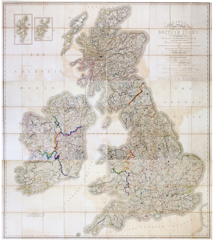
CARY (John).
Cary's New Map of the British Isles, exhibiting the whole of the Turnpike roads both direct & cross, particularly distinguishing those on which the mail coaches travel.
London, John Cary, 1819-1833. En trois feuilles coupées en 30 sections chacune, montées sur toile et pliées, pouvant être jointes pour former une carte de 1,91 x 1,71 m ; plats au dos de percaline prune, protégeant les feuilles une fois repliées, avec vignettes portant les titres de North, Center et South ; sous étui de percaline prune avec vignette de titre sur le premier plat.
Bookseller reference : LBW-6802
|
|
|
Cartes ITM
Carte routière : North Korea
Bookseller reference : CYE43RT
|
|
|
Cartes ITM
Carte routière : Antigua
Bookseller reference : CYE47RT
|
|
|
CARPENTRAS
Carte au 1/100.000 de l'arrondissement de Carpentras.
1893 cartonnage toilé rouge éditeur. carte repliée, 450 x560mm., en couleurs, P. Hachette 1893
Bookseller reference : 17166
|
|
|
Cartes Taride,
Carte Taride. Nouvelle carte du Maroc. Echelle 1/1 200 000. Tirage en 5 couleurs.
n.d. (ca. 1930) large (80 x 93 cm) folded col. map, in printed paper pocket.
Bookseller reference : TA29503
|
|
|
CARTE.
Carte de Rouen, Magny, Vernon, 1757.
1757 Encre sur papier collé sur toile, 92.5x58.5cm.
Bookseller reference : 9247

|
|
|
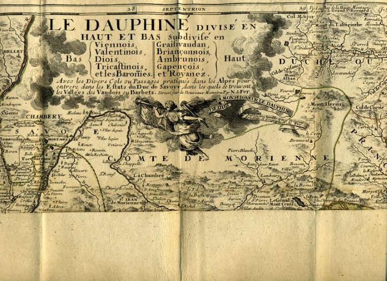
CARTE.
Carte du Dauphiné.
Paris 1693 1 Paris, chez l'auteur dans l'Ilse du Palais, 1693, sous étui cartonné.
Bookseller reference : 11444
|
|
|
CARTES TARIDE
CARTE ROUTIERE N ° 17 POUR CYCLISTES & AUTOMOBILISTES DU CENTRE DE LA FRANCE, SECTION SUD EST de marseille a nice et de nice a la frontiere italienne
EDITIONS TARIDE -: Carte dépliante entoilée en couleurs en 35 volets, en couleurs . In-Plano Broché.
Bookseller reference : 2056
|
|
|
Cartes Office Fédéral de Topographie Suisse
Carte de randonnée : Val Travers pédestre
Office Fédéral de Topographie Suisse; Nouvelle (31 octobre 2001)
Bookseller reference : lc_7809
|
|
|
Cartes taride
Carte Taride - Nouvelle carte du Maroc - Echelle 1/1 200 000 - Tirage en 5 couleurs
Paris, A. Taride Ed. - sans date, 1930 ?- - 80 x 95 cm - Pliée sous pochette - bon ex.
Bookseller reference : 16500
|
|
|
Carte postale ancienne
Catastrophe du cuirassé Liberté - 25 Septembre 1911 - Les mâtures opèrent pour découvrir les victimes
Marius Bar, Toulon, numéro 15 de la série, N&B | Etat : Très bon état général, non utilisée (Ref.: JCP33)
Bookseller reference : 4419
|
|
|
Carte postale ancienne
Catastrophe du Liberté le 25 Septembre 1911 - Le République détérioré par l'explosion
ELD, carte en N&B | Etat : Bon état, non utilisée, quelques piqures (Ref.: JCP36)
Bookseller reference : 4422
|
|
|
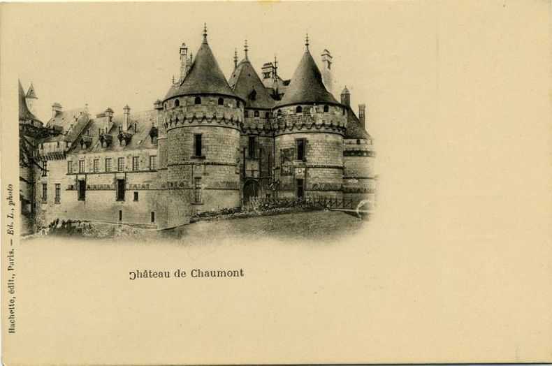
CARTES POSTALES.
Châteaux de France.
Hachette 1910 Photographies, 25 sujets, 2e série, sous pochette cartonnée verte (1910).
Bookseller reference : 17598
|
|
|
Cartes postales anciennes
Collection de près de 350 cartes postales de la Belle époque
Slnd 1900 In-folio, oblong, plein chagrin marron, près de 350 cartes logées sur 48 ff. La plupart timbrées et affranchies, avec du texte manuscrit au verso, parfois aussi au recto. Intégralement bucolique, sentimental et familial, très nombreux portraits féminins, de couples et d’enfants. Album fané sinon bon état général.
Bookseller reference : 136792

|
|
|
CARTES DE JEU SUPPLEMENTAIRES POUR LE DE DES PREMIERS MOTS
DE DES PREMIERS MOTS / CARTES SUPPLEMENTAIRES
PASSE-TEMPS EDITIONS
Bookseller reference : SVBLIVCN-9830096007901
|
|
|
CARTES À JOUER
Déclaration du Roy, donnée à Fontainebleau le 21 Octobre 1746. Qui ordonne ce qui doit être fait pour la perception du droit établi sur les cartes par celle du 16 Février 1745
S.l. [Grenoble] s.d. [1747] in-4 en feuilles
Bookseller reference : 2167
|
|
|
CARTES À JOUER
Déclaration du Roy, donnée à Fontainebleau le 21 octobre 1746. Qui ordonne ce qui doit être fait pour la perception du droit établi sur les cartes par celle du 16 février 1745
1746 pet. in-4 (17,85 x 23,1 cm) de 8 pp. dérelié
Bookseller reference : 20277
|
|
|
Carte postale
Ecole Primaire Supérieure et Professionnelle d'Aubenas. - Un réfectoire.
s.l., s.n., s.d. (dbut XXème), 1 carte postale de 14 x 9 cm, expéditeur: "Elie Niel, surveillant à l'école supérieure d'Aubenas" ;
Bookseller reference : 12919
|
|
|
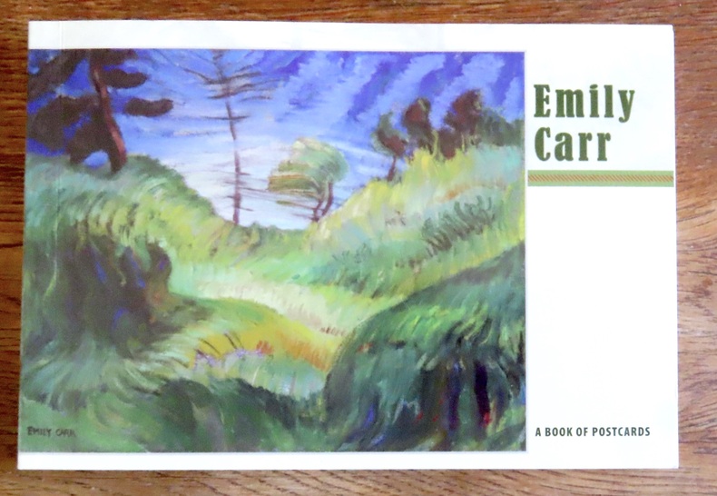
Carr Emily:
Emily Carr - A book of postcards.
Portland, Pomegranate, 2008. Livret composé de 30 cartes postales au format 18 x 12. Un carte détachée, les autres reliées encore mais détachables bien sûr, le book est complet des 30 cartes.
Bookseller reference : 15602
|
|
|
Carte postale ancienne
Funérailles des victimes de la terrible catastrophe du Liberté - Le président et sa suite
L.L., numéro 7 de la série, carte en N&B | Etat : Non utilisée, très bon état général (Ref.: JCP29)
Bookseller reference : 4415
|
|
|
Carte postale ancienne
Funerailles des victimes de la terrible catastrophe du Liberté - Les couronnes
L.L., numéro 3 de la série, N&B | Etat : Non utilisée, très bon état général (Ref.: JCP30)
Bookseller reference : 4416
|
|
|
Carte postale ancienne
Funérailles des victimes du Liberté - Le Clergé au Cortège
Giraud, Toulon, carte en N&B | Etat : Très bon état général, non utilisée (Ref.: JCP32)
Bookseller reference : 4418
|
|
|
Carte postale
GROTTES DU LAUTARET - La Bégude.
Avignon, Prévot, s.d. (début XXème) 1 Carte postale de 9 x 14 cm.
Bookseller reference : 15326
|
|
|
CARMICHAEL, Joel
Histoire illustrée de la Russie
1960 Editions NRF Gallimard, Collection "L'Oeil" - 1960 - In-4, cartonnage rouge illustré - 303 p. - Illustrations et reproductions photographiques en N&B in et hors-texte
Bookseller reference : 109620
|
|
|
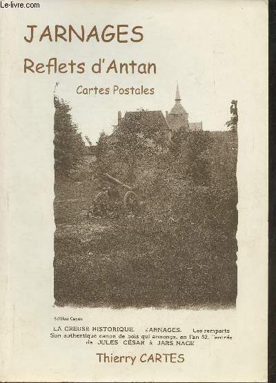
Cartes Thierry
Jarnages, reflets d'Antan- Cartes postales
Edition Cayon. 2010. In-4. Broché. Bon état, Coins frottés, Dos satisfaisant, Intérieur acceptable. 161 pages. Nombreuses photos en noir et blanc, in et hors texte.. . . . Classification Dewey : 908.447-Régionalisme : Aquitaine
Bookseller reference : RO30362028 ISBN : 274661894
|
|
|
CARTES A JOUER NAPOLÉONIENNES.-
Jeu de 32 + 4 cartes en 2 planches gravées.-
S.l.n.d. Vers 1850. 2 planches sur papier fort, d'environ 54 x 41 cm, contenant chacune 18 cartes en noir et blanc, chacune d'elles constituée d'une scène de l'histoire napoléonienne au-dessus de 2 bustes de généraux de l'Empire. Jeu complet des 32 cartes plus 4 cartes non identifiées sans doute pour compléter la planche. Bords un peu fendillés, un peu fragilisés sur la 2e planche, sans atteinte aux cartes, petite réparation, pâles rousseurs essentiellement marginales. Assez bon exemplaire, peu courant.
Bookseller reference : ORD-15119
|
|
|
Carte postale
Joyeuse, cité médiévale en Cévennes d'Ardèche. Tapisserie murale de l'hotel de Montravel "Joyeuse au 16e s.".
Les Vans, Céven,art, s.d. (1993 ou 94), 1 carte postale de 10 x 14 cm, en couleur, légendée: "Joyeuse cité médiévale en cévennes d'Ardèche".
Bookseller reference : 7514
|
|
|
Carte postale
L'Ardèche illustrée - VERNOUX (alt. 585 m). Une vue sur le Gour du Ranc. La plage de Vernoux.
Macon, Cim, 1952, 1 carte postale de 14 x 9 cm.
Bookseller reference : 12987
|
|
|
Carte postale
L'Ardèche illustrée. Environs d'Annonay - CHATEAU DE THORRENC.
Paris, B. F., s.d. (début XXème), 1 carte postale de 14 x 9 cm.
Bookseller reference : 12939
|
|
|
Carte postale
L'Ardèche pittoresque. St-MICHEL-DE-CHABRILLANOUX. Un des nombreux sous-bois.
Valence, Serre, 1933, 1 carte postale de 14 x 9 cm ;
Bookseller reference : 12932
|
|
|
Carte postale ancienne
La guerre de 1914 - 182 - Nouveau canon allemand contre aéroplanes
L.C.H. Paris, écrite (au crayon), sans timbre, avec tampon postal | Etat : Bon état général (Ref.: JCP13)
Bookseller reference : 4395
|
|
|
Carte postale ancienne
La catastophe du cuirassé Liberté - 25 Septembre 1911 - Vue générale après l'explosion - Le Cuirassé Liberté entouré de débris de bois
L.L., carte en N&B | Etat : état moyen, traces de colles, note au stylo (Ref.: JCP34)
Bookseller reference : 4420
|
|
|
Carte postale ancienne
La catastophe du cuirassé Liberté - 25 Septembre 1911 - Vue générale après l'explosion - Le Cuirassé Liberté entouré de débris de bois
L.L., carte en N&B | Etat : Bon état, non utilisée, coin supérieur légèrement plié (Ref.: JCP35)
Bookseller reference : 4421
|
|
|
Carte postale ancienne
La Guerre 1914 LE CHEVAL REQUISITIONNE (la plus noble conquête de l'homme) reçoit au sabot son numéro matricule
1914 1ère série, n°37. Provost, Toulouse. | Etat : Ecriture. Oblitéré sur l'image. (Ref.: JCP4)
Bookseller reference : 5970
|
|
|
Carte postale
LE CHEYLARD. - Le chateau de la Chèze.
Le Cheylard, Héritier, s.d. (vers 1909), 1 carte postale de 14 x 9 cm, oblitérée.
Bookseller reference : 14013
|
|
|
Carte postale PRINSAC (Gaston).
Le Château de Boulogne. - Le portail.
Saint-Etienne de Boulogne, cliché Prinsac, s.d. (début XXème), 1 carte postale de 9 x 14 cm.
Bookseller reference : 13661
|
|
|
Carte postale
Le Pouzin. - Vallée de l'Ouvèze..
Le Pouzin, Cappeau, s.d. (début XXème), 1 carte postale de 14 x 9 cm.
Bookseller reference : 12983
|
|
|
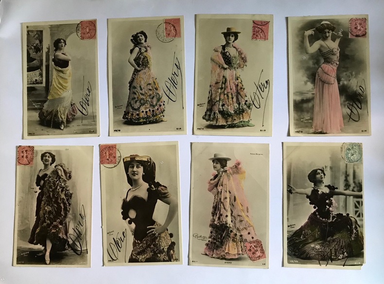
CARTES POSTALES - REUTLINGER, photographe.
Le Belle Otéro.
1908 Paris, Editions S.I.P., ( vers 1908); 8 cartes postales anciennes en couleurs représentant la Belle Otéro dans des costumes de scène différents, toutes , sauf 1 avec le fac-similé de la signature de l'actrice. Toutes ont voyagé, timbre oblitéré sur chacune.
Bookseller reference : 10635
|
|
 Receive by email
 Download as PDF document
 RSS feed


