|
Cartes Taride,
Carte Taride. Nouvelle carte du Maroc. Echelle 1/1 200 000. Tirage en 5 couleurs.
n.d. (ca. 1930) large (80 x 93 cm) folded col. map, in printed paper pocket.
Bookseller reference : TA29503
|
|
|
CARTES TAROT
XIII TAROT
LO SCARABEO
Bookseller reference : SVBLIVCN-8420707450915
|
|
|
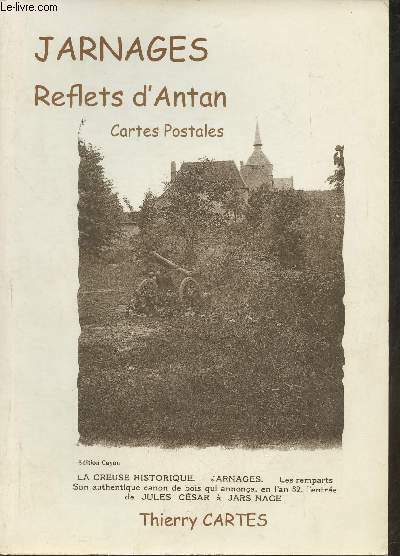
Cartes Thierry
Jarnages, reflets d'Antan- Cartes postales
Edition Cayon. 2010. In-4. Broché. Bon état, Coins frottés, Dos satisfaisant, Intérieur acceptable. 161 pages. Nombreuses photos en noir et blanc, in et hors texte.. . . . Classification Dewey : 908.447-Régionalisme : Aquitaine
Bookseller reference : RO30362028 ISBN : 274661894
|
|
|
CARTES À JOUER
Arrest du Conseil d'Etat du Roi, concernant la forme de l'établissement & de la perception, dans la Principauté de Dombes, du droit y établi sur les cartes à jouer, au profit de l'Ecole Royale militaire, par les lettres patentes du 6 septembre 1772. Du 20 février 1773
Paris P.-G. Simon 1773 in-4 en feuille
Bookseller reference : 33051
|
|
|
CARTES À JOUER
Arrest du Conseil d'Etat du Roi, qui ordonne que sans s'arrêter ni avoir égard à l'arrêt du Parlement de Rouen du 19 mars 1770, le règlement du 9 novembre 1751 concernant la perception du droit sur les cartes à jouer, ensemble les arrêts du Conseil des 23 janvier 1751 & 15 octobre 1757, portant attribution aux sieurs commissaires du bureau des Oblats & aux sieurs intendans dans les provinces, de la connoissance des contraventions concernant ledit droit, seront exécutés selon leur forme & teneur &c. Du 21 avril 1770
Paris P.-G. Simon 1775 in-4 en feuille
Bookseller reference : 33052
|
|
|
CARTES À JOUER
Arrest du Conseil d'État du Roi, qui ordonne, à commencer du 1er Octobre 1769, l'augmentation du prix marchand du papier Pot filigrané, fourni par le régisseur du droit sur les cartes, aux cartiers du royaume,en exécution de l'Arrêt du 9 Novembre 1751. Du 28 Juillet 1769
Paris P.G. Simon 1769 in-4 en feuilles
Bookseller reference : 2174
|
|
|
CARTES À JOUER
Arrêté du Directoire exécutif, concernant la fabrication des cartes à jouer. Du 21 vendémiaire, an VII de la République française, une et indivisible [12 octobre 1798]
Saintes Imprimerie de Corinthe, Josserand et Hus s.d. [1798] placard in-folio (47 x 38 cm) en feuille
Bookseller reference : 35467
|
|
|
CARTES À JOUER
Déclaration du Roy, donnée à Fontainebleau le 21 Octobre 1746. Qui ordonne ce qui doit être fait pour la perception du droit établi sur les cartes par celle du 16 Février 1745
S.l. [Grenoble] s.d. [1747] in-4 en feuilles
Bookseller reference : 2167
|
|
|
CARTES À JOUER
Déclaration du Roy, donnée à Fontainebleau le 21 octobre 1746. Qui ordonne ce qui doit être fait pour la perception du droit établi sur les cartes par celle du 16 février 1745
1746 pet. in-4 (17,85 x 23,1 cm) de 8 pp. dérelié
Bookseller reference : 20277
|
|
|
CARTES À JOUER
Nouveau jeu de l'hombre, comme on le joüe présentement à la Cour & à Paris ; où l'on voit comment se joüe espadille forcé, l'hombre à deux, à trois & à cinq. Avec l'explication des termes dont on se sert en le joüant
La Haye Jacob Van Elinckhuysen 1702 in-12 vélin souple, dos lisse muet [Rel. de l'époque]
Bookseller reference : 25843
|
|
|
CARTES À JOUER
Nouvelles cartes à jouer de la République française
[Paris] Imprimerie des nouvelles cartes de la République française s.d. [1793] in-8 broché sous couverture factice moderne
Bookseller reference : 32841
|
|
|
CARTES À JOUER
Édit du Roy, donné à Fontainebleau au mois d'octobre 1701. Portant établissement au profit de Sa Majesté d'un droit de dix-huit deniers sur chaque ieu de cartes à joüer, & règlement pour les maîtres cartiers
Grenoble Alexandre Giroud 1701 in-4 dérelié, sous papier d'attente gris
Bookseller reference : 36186
|
|
|
CARTESIO, Renato (René Descartes)
Epistolae
Tre voll. I primi due sono stampati da Elzevirio nel 1668 (4 cc + 383 + 2 cc.; 2 cc. + 404 + 2 cc.; il terzo è stampato da Blaeu nell’83 (8 cc + 427). Piena pergamena, ottimi esemplari, raro e importante.
|
|
|
CARTESIO, Renato (René Descartes)
Meditationes De Prima Philosophia / Appendix, continens objectiones quintas & septimas in Renati Descartes Meditationes (+ Epistola ... Ad ... D. Gisbertum Voetium / Principia Philosophiae
In -4° P. Pergamena, tre volumi rilegati assieme: B, (12) 191 (1 b.); 164 (appendix), 88 (epistola a Voetius, la numerazione riparte); 18 cc., 222, 3 cc. B. Nelle “Meditationes”, opera volta a stabilire cosa possa essere conosciuto con certezza, Cartesio adopera per la prima volta l’espressione “Cogito ergo sum”. L’“Appendix” si trova solitamente rilegata con le “Meditationes” ma ha un frontespizio e numerazione autonoma delle pp. così come autonoma è la numerazione della successiva Epistola al teologo olandese Voetius, suo avversario. Volume a sé (ma rilegato con questi) è i “Principia”, che fu peraltro stampato nell’anno successivo.
|
|
|
CARTESIO, Renato (René Descartes)
Specimina philosophiae seu dissertatio de methodo ... Dioptrice et Meteora / Passiones Animae
In -4° P. Pergamena, due volumi rilegati assieme: 8 cc + 248; 92 + 2 cc (Passiones)
|
|
|
CARUELLE d'ALIGNY (Théodore).
[CAPRI] Royaume de Naples. Vue prise dans l'île de Capri.
1844. 267 x 380 mm.
Bookseller reference : LBW-5974
|
|
|
CARUELLE d'ALIGNY (Théodore).
Campagne de Rome. Vue prise sur l'ancienne voie des tombeaux.
1844. 267 x 382 mm.
Bookseller reference : LBW-5973

|
|
|
Caruso John Anthony. Maps by Neil E. Bolyard
Mississippi Valley Frontier: The Age of French Exploration and Settlement
Indianapolis: Bobbs-Merrill 1966. 423 pp. maps in text. With ownership name stamp of anthropologist Richard Erdoes. Covers a bit dull page edges tanned and dusty. Jacket stained at spine dustsoiled lightly edgeworn. First Edition. Hard Cover. Very Good/Good. 8vo. Bobbs-Merrill Hardcover
Bookseller reference : C8430
|
|
|
Caruso John Anthony/Bolyard Neil E. maps
The Mississippi Valley Frontier: The Age of French Exploration and Settlement
Indianapolis: Bobbs Merrill Co. 1966. 1st printing. VG/VG dust jacket name on front endpaper/bottom fore-edge. xiv 423 p. maps notes biblio index 8vo; Bobbs Merrill Co. hardcover
Bookseller reference : 51625

|
|
|
Carver Jonathan Robert Sayer and John Bennett Firm publisher Library of Congress. American maps ; v. no. .
A new map of the province of Quebec according to the Royal Proclamation of the 7th of October 1763. : From the French surveys connected with those made after the war. 1776 Leather Bound
2019. Leather Bound. New. Leather Binding on Spine and Corners with Golden Leaf Printing on round Spine extra customization on request like complete leather Golden Screen printing in Front Color Leather Colored book etc. Reprinted in 2019 with the help of original edition published long back 1776. This book is printed in black & white sewing binding for longer life Printed on high quality Paper re-sized as per Current standards professionally processed without changing its contents. As these are old books we processed each page manually and make them readable but in some cases some pages which are blur or missing or black spots. If it is multi volume set then it is only single volume if you wish to order a specific or all the volumes you may contact us. We expect that you will understand our compulsion in these books. We found this book important for the readers who want to know more about our old treasure so we brought it back to the shelves. Hope you will like it and give your comments and suggestions. Lang: - English. EXTRA 10 DAYS APART FROM THE NORMAL SHIPPING PERIOD WILL BE REQUIRED FOR LEATHER BOUND BOOKS. COMPLETE LEATHER WILL COST YOU EXTRA US$ 25 APART FROM THE LEATHER BOUND BOOKS. hardcover
Bookseller reference : LB1111009007583
|
|
|
Carver Jonathan Robert Sayer and John Bennett Firm publisher Library of Congress. American maps ; v. no. .
A new map of the province of Quebec according to the Royal Proclamation of the 7th of October 1763. : From the French surveys connected with those made after the war. 1776 FULL LEATHER BOUND
2019. SUPER DELUXE EDITION. New. Antique look with Golden Leaf Printing and embossing with round Spine completely handmade bindingextra customization on request like Color Leather Colored book special gold leaf printing etc. Reprinted in 2019 with the help of original edition published long back 1776. This book is printed in black & white sewing binding for longer life Printed on high quality Paper re-sized as per Current standards professionally processed without changing its contents. As these are old books we processed each page manually and make them readable but in some cases some pages which are blur or missing or black spots. If it is multi volume set then it is only single volume if you wish to order a specific or all the volumes you may contact us. We expect that you will understand our compulsion in these books. We found this book important for the readers who want to know more about our old treasure in old look so we brought it back to the shelves. Hope you will like it and give your comments and suggestions. Lang: - English. EXTRA 10 DAYS APART FROM THE NORMAL SHIPPING PERIOD WILL BE REQUIRED. Normal Hardbound Edition is also available on request. unknown
Bookseller reference : SD1111009007583
|
|
|
Carver Jonathan Robert Sayer and John Bennett Firm publisher Library of Congress. American maps ; v. no. .
A new map of the province of Quebec according to the Royal Proclamation of the 7th of October 1763. : From the French surveys connected with those made after the war. 1776
2019. Paperback. New. Lang: - English. Reprinted in 2019 with the help of original edition published long back 1776. This book is Printed in black & white sewing binding for longer life with Matt laminated multi-Colour Soft Cover HARDCOVER EDITION IS ALSO AVAILABLE Printed on high quality Paper re-sized as per Current standards professionally processed without changing its contents. As these are old books we processed each page manually and make them readable but in some cases some pages which are blur or missing or black spots. If it is multi volume set then it is only single volume if you wish to order a specific or all the volumes you may contact us. We expect that you will understand our compulsion in these books. We found this book important for the readers who want to know more about our old treasure so we brought it back to the shelves. Any type of Customisation is possible with extra charges. Hope you will like it and give your comments and suggestions. paperback
Bookseller reference : PB1111009007583
|
|
|
Carver Jonathan Robert Sayer and John Bennett Firm publisher Library of Congress. American maps ; v. no. .
A new map of the province of Quebec according to the Royal Proclamation of the 7th of October 1763. : From the French surveys connected with those made after the war. 1776 Hardcover
2019. Hardcover. New. Lang: - English. Reprinted in 2019 with the help of original edition published long back 1776. This book is Printed in black & white Hardcover sewing binding for longer life with Matt laminated multi-Colour Dust Cover Printed on high quality Paper re-sized as per Current standards professionally processed without changing its contents. As these are old books we processed each page manually and make them readable but in some cases some pages which are blur or missing or black spots. If it is multi volume set then it is only single volume if you wish to order a specific or all the volumes you may contact us. We expect that you will understand our compulsion in these books. We found this book important for the readers who want to know more about our old treasure so we brought it back to the shelves. Any type of Customisation is possible with extra charges. Hope you will like it and give your comments and suggestions. hardcover
Bookseller reference : 1111009007583
|
|
|
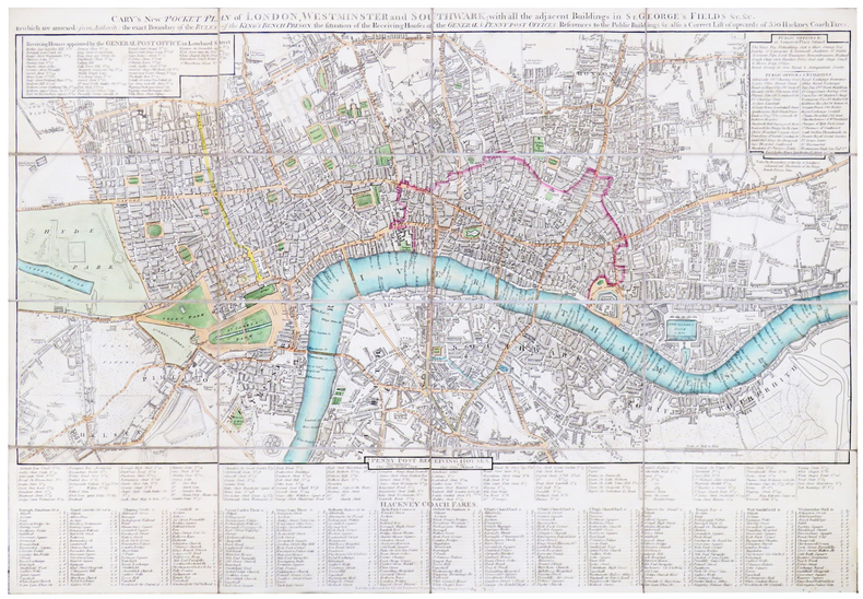
CARY (John).
[LONDRES] Cary's new pocket plan of London, Westminster and Southwark; with all the adjacent buildings in St. George's Fields &c &c.
London, J. Cary, 1819. En 16 sections montées sur toile et pliées, formant un plan de 420 x 613 mm.
Bookseller reference : LBW-5395
|
|
|
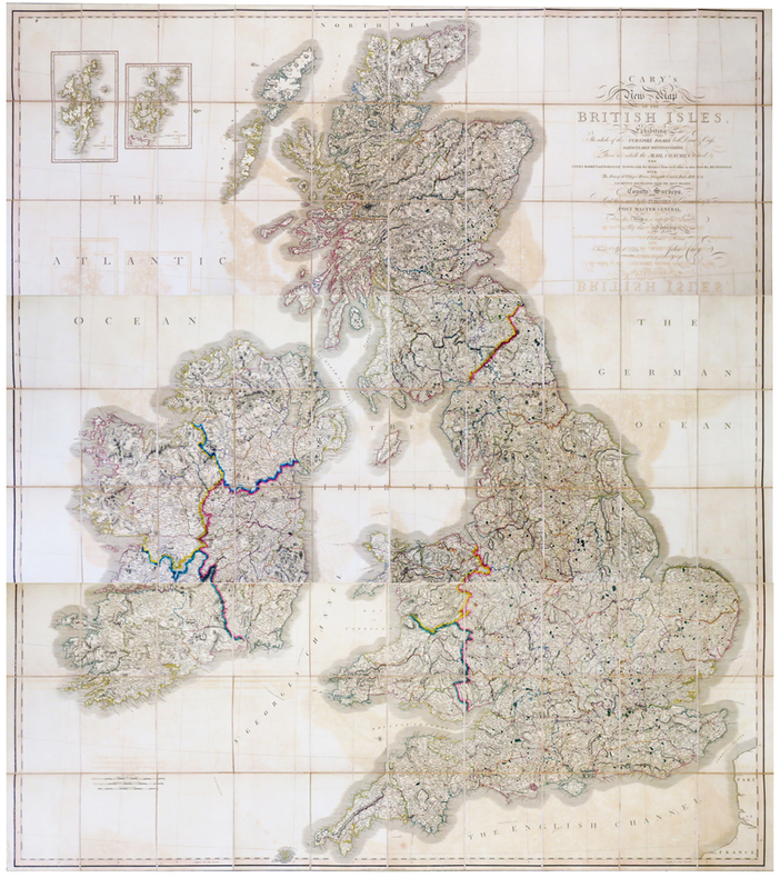
CARY (John).
Cary's New Map of the British Isles, exhibiting the whole of the Turnpike roads both direct & cross, particularly distinguishing those on which the mail coaches travel.
London, John Cary, 1819-1833. En trois feuilles coupées en 30 sections chacune, montées sur toile et pliées, pouvant être jointes pour former une carte de 1,91 x 1,71 m ; plats au dos de percaline prune, protégeant les feuilles une fois repliées, avec vignettes portant les titres de North, Center et South ; sous étui de percaline prune avec vignette de titre sur le premier plat.
Bookseller reference : LBW-6802
|
|
|
Cary, John
A new map of the circles of the upper and lower Rhine. 1799. [Original-Kupferstich / original copper engraving].
o.J. [3 Warenabbildungen] (John Cary, geb. ca. 1754, gest. 1835, englischer Kartograph, Graveur, Globenmacher und Verleger).
Bookseller reference : 66506CB

|
|
|
CASATI Gaetano:
Dix années en Équatoria. Le retour d'Emin Pacha et l'Expédition Stanley. Ouvrage traduit avec l'autorisation de l'auteur par Louis de Hessem.
Paris, Librairie de Firmin Didot, 1892. In-4 de XI-[1]-498-[2] pages, demi-chagrin rouge à coins, dos à nerfs ornés de filets et fleurons dorés, tête dorée.
Bookseller reference : 20576

|
|
|
CASAÑAL Y ZAPATERO, Dionisio.
Bosquejo Geográfico de la Provincia de Zaragoza formado por encargo de la Excelentísima Diputación Provincial para servir de base al Plan General de Caminos Vecinales.
Zaragoza, Litografía de E. Portabella y Compañía, 1903. Mapa de 122 x 126 cms. litografíado en color, montado sobre tela y plegado. Ejemplar con envío auógrafo de Dionisio Casañal. Encuadernación de época en tela.

|
|
|
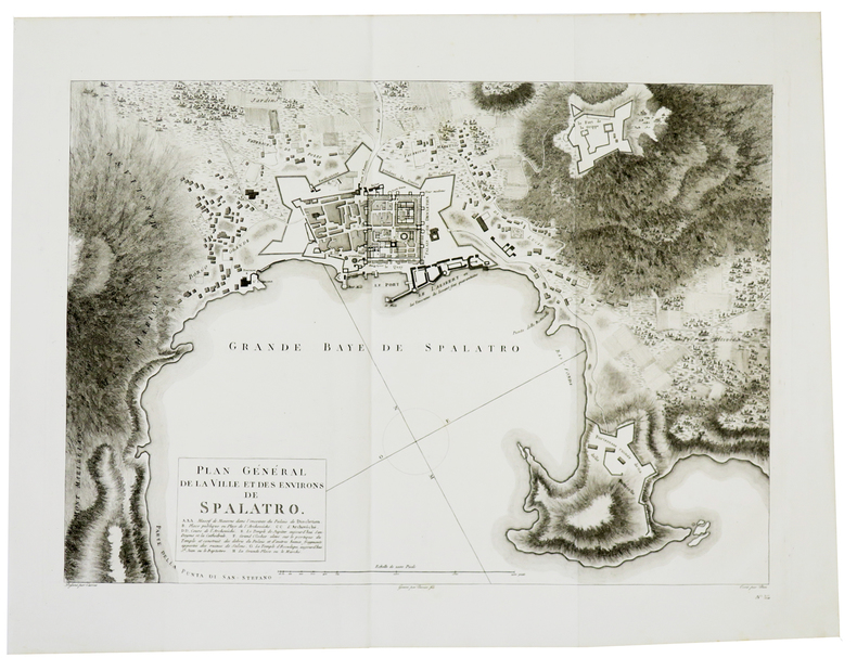
CASSAS (Louis-François).
[CROATIE] Plan général de la ville et des environs de Spalatro.
[Paris, 1802]. 407 x 567 mm.
Bookseller reference : LBW-822
|
|
|
CASSAS (Louis-François).
[CROATIE] Vue générale de Spalatro. Prise en mer près la Punta di St. Stefano.
[Paris, 1802]. 266 x 458 mm.
Bookseller reference : LBW-826

|
|
|
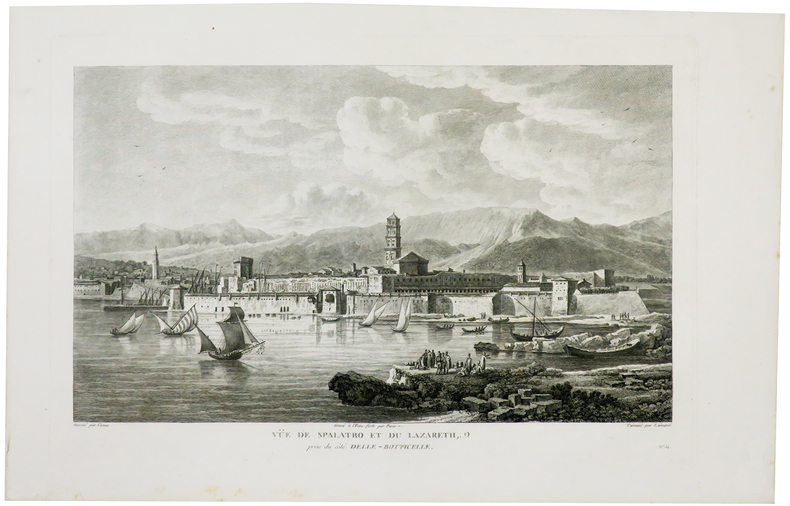
CASSAS (Louis-François).
[CROATIE] Vüe de Spalatro et du Lazareth, prise du côté Elle-Botticelle.
[Paris, 1802]. 257 x 399 mm.
Bookseller reference : LBW-5909
|
|
|
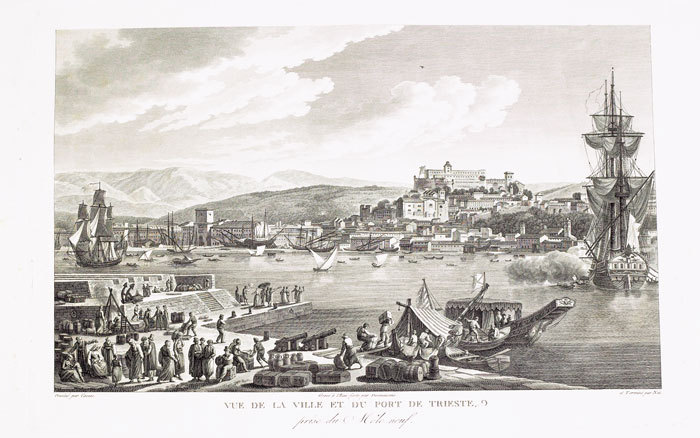
CASSAS (Louis-François).
[TRIESTE] Vue de la ville et du port de Trieste, prise du Môle neuf.
[Paris, 1802]. 270 x 405 mm.
Bookseller reference : LBW-823
|
|
|
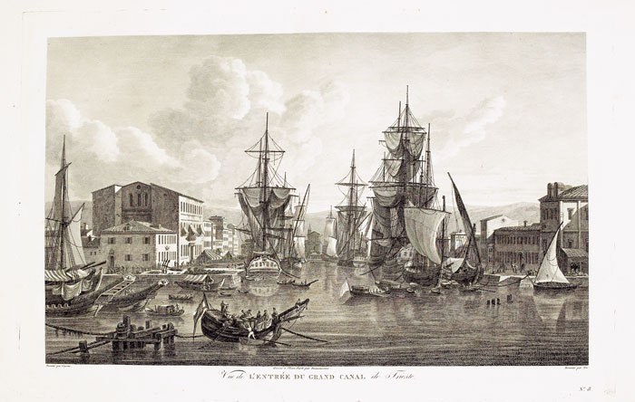
CASSAS (Louis-François).
[TRIESTE] Vue de l’entrée du grand canal de Trieste.
[Paris, 1802]. 252 x 399 mm.
Bookseller reference : LBW-825
|
|
|
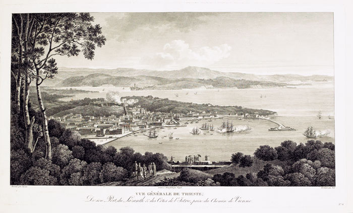
CASSAS (Louis-François).
[TRIESTE] Vue générale de Trieste, de son port, du Lazareth & des côtes de l’Istrie, prise du chemin de Vienne.
[Paris, 1802]. 266 x 451 mm.
Bookseller reference : LBW-824
|
|
|
CASSINI
Carte de Cassini N° 78. Charleville-Mézière.
1800 carte usagée. 21 sections montées sur toile et pliées, formant une carte de 610 x 930 mm. P. s.d., 1800
Bookseller reference : 16325
|
|
|
CASSINI
CARTE de la région de TOUL n°111 flle 41 (1759)
De format 920 X 600, entoilage d'époque, avec la vignette imprimée du libraire (le Sr Desnos, rue St Jacques ), la carte est divisée en 21 parties permettant le pliage en accordéon sans dommage pour le papier. Exemplaire en couleurs, forêts, bourgs importants. 1759.
Bookseller reference : 2353

|
|
|
CASSINI
Carte N° 152 : Laragne , Embrun.
Carte 590 x 1170 mm., toile saumon XVIIIe.
Bookseller reference : 11535
|
|
|
CASSINI
Carte N° 166 Vence
toile saumon XVIIIe. H 59 L 66 cms.
Bookseller reference : 11536
|
|
|
CASSINI
Carte N° 167 Fréjus Antibes.
toile saumon XVIIIe. H 60 L 53 cms.
Bookseller reference : 11539
|
|
|
CASSINI
Carte N° 45 : Meaux; La Ferté sous Jouarre, Montmirail, Coulommiers.
coloriée, toilée.
Bookseller reference : 11865
|
|
|
CASSINI
Carte N° 62 : Argentan
coloriée, toilée.
Bookseller reference : 11864
|
|
|
CASSINI
Carte N° 83 : Montbar, Flavigny, Sémur, Avallon.
coloriée, toilée.
Bookseller reference : 11868
|
|
|
CASSINI
Carte n°44 (région de Soissons)
De format 930 X 600, entoilage d'époque, pliage en 18 parties. Imprimée en noir en 1757. Avec les forêts de Compiègne et de Villers-Cotterets. Figurent La Ferté Millon, , Etrepilly, Chatillon, la rivière l'Ourcq et un méandre de la Marne au sud. Bon exemplaire, quelques taches claires (traces d'humidité). Vignette imprimée de marchand d'estampes au quai Voltaire sur la toile du premier pli.
Bookseller reference : 2364

|
|
|
CASSINI
Carte n°45 MEAUX Coulommiers Montmirail Chateau Thierry La Ferté Gaucher
De format 920 X 595, entoilage d'époque, pliage en 21 parties. Impression en couleurs de 1757. Vignette ronde gravée du libraire et Ingénieur géographe Desnos à Paris, contrecollée sur la toile au premier pli. Bon exemplaire.
Bookseller reference : 2367

|
|
|
CASSINI
Cartes N° 112, 142, 144, 163 correspondant à : Colmar, Nancy, Luxeuil et Joinville,
1790 étui en cartonnage parcheminé vert, piece de titre rouge. toile vieux rose, coloriées
Bookseller reference : 6884
|
|
|
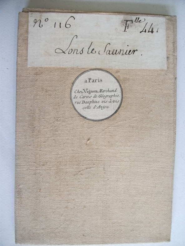
CASSINI de THORY
LONS LE SAUNIER
Vignon marchand de cartes de géographie Paris. N°116 feuille 44 ,LONS LE SAUNIER,carte entoilée.,Pliée 13x20cm dépliée 90x60 échelle 10 000 toises
Bookseller reference : 6736
|
|
|
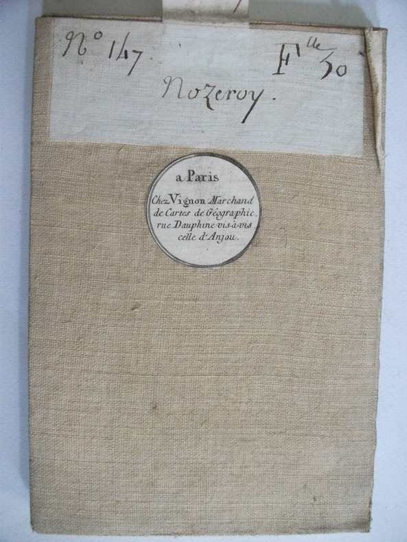
CASSINI de THORY
NOZEROY carte entoilée.
marchand de cartes de géographie Paris. N°147 feuille 30 NOZEROY carte entoilée.Pliée 13x20cm dépliée 90x60 échelle 10 000 toises.
Bookseller reference : 6734
|
|
|
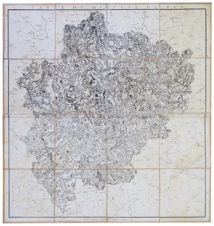
CASSINI de THURY (César-François) & CAPITAINE (Louis).
[LE PUY-en-VELAY] Carte du diocèse du Puy.
[1781]. En 16 sections montées sur toile et pliées, formant une carte de 983 x 964 mm.
Bookseller reference : LBW-2802
|
|
|
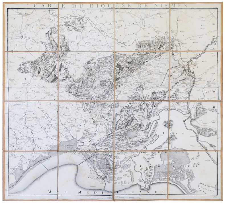
CASSINI de THURY (César-François) & CAPITAINE (Louis).
[NISMES] Carte du diocèse de Nismes.
[1781]. En 16 sections montées sur toile et pliées, formant une carte de 882 x 955 mm.
Bookseller reference : LBW-2803
|
|
|
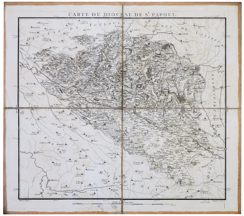
CASSINI de THURY (César-François) & CAPITAINE (Louis).
[SAINT-PAPOUL] Carte du diocèse de St. Papoul.
[1781]. En 4 sections montées sur toile et pliées, formant une carte de 471 x 533 mm.
Bookseller reference : LBW-2809
|
|
 Receive by email
 Download as PDF document
 RSS feed


