|
|
|
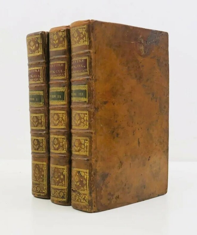
CRÈVECŒUR (Hector Saint-John de)
Voyage dans la Haute Pensylvanie et dans l'État de New York, par un membre adoptif de la Nation Onéida.
Paris, Maradan, 1801. 3 volumes in-8, demi-basane brune, dos lisse orné, tranches jonquille (Reliure de l'époque). Édition originale, illustrée de 3 portraits, de 4 (sur 6) planches gravées dépliantes, de 2 grandes cartes dépliantes des États-Unis et de 4 tableaux, timbres, déchirures sans manque aux cartes, petites rousseurs
書籍販売業者の参照番号
: PHO-1645

|
|
|
CRÉPY (Étienne-Louis).
[BERRY/BOURBONNAIS/NIVERNAIS] Les provinces de Berry, Bourbonnois et Nivernois, divisée par élections. Dressé sur les mémoires les plus nouveaux.
Paris, Crépy, 1780. 500 x 680 mm ; repliée sous couverture cartonnée recouverte de papier bleu de l'époque (195 x 127 mm) ; étiquette sur le premier plat portant le titre manuscrit à l'encre.
書籍販売業者の参照番号
: LBW-8430

|
|
|
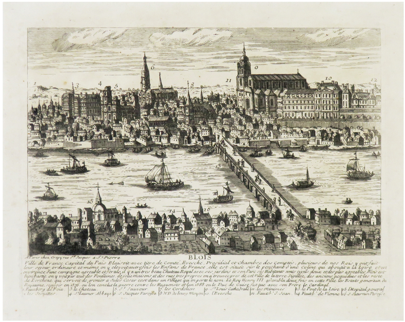
CRÉPY (Louis) & AVELINE (Pierre).
[BLOIS] Blois, ville de France, capital du Païs Blaisoit.
Paris, Crépy, [circa 1720]. 175 x 236 mm.
書籍販売業者の参照番号
: LBW-6819
|
|
|
CRÉPY (Étienne-Louis).
[JEU de l'OIE] Les Travaux de Mars, ou Nouveau Jeu de la Guerre, dédié à la jeune noblesse de France.
Paris, Crépy, 1767. 428 x 541 mm.
書籍販売業者の参照番号
: LBW-8536

|
|
|
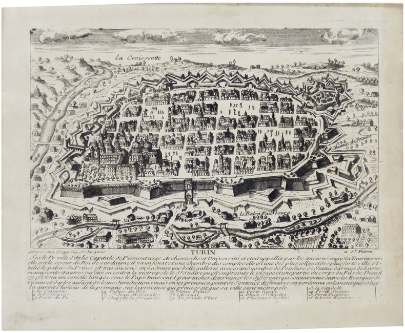
CRÉPY (Louis) & AVELINE (Pierre).
[TURIN] Turin, sur le Po, ville d'Italie, capitale de Piémont.
Paris, Crépy, [circa 1720]. 167x 213 mm.
書籍販売業者の参照番号
: LBW-6847
|
|
|
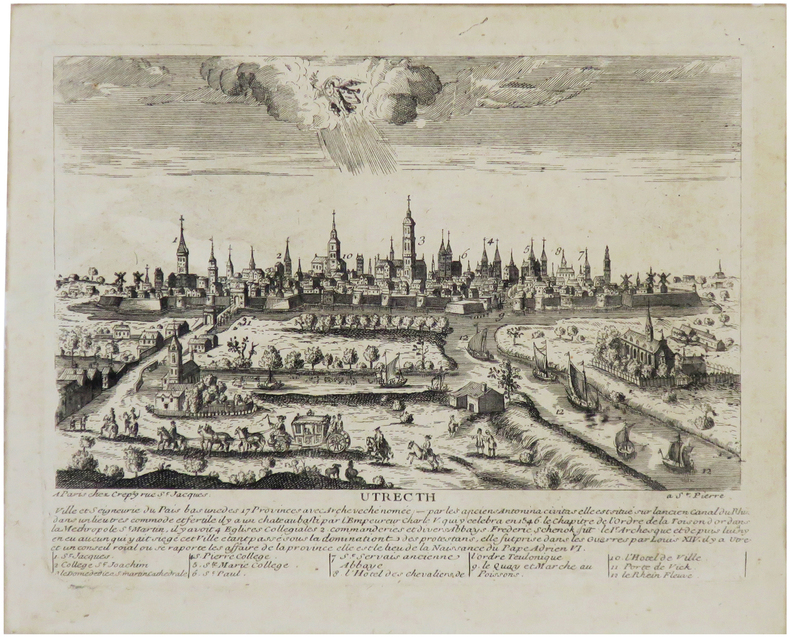
CRÉPY (Louis) & AVELINE (Pierre).
[UTRECHT] Utrecth ville et seigneurie du Pais Bas, une des 17 provinces.
Paris, Crépy, [circa 1720]. 171 x 224 mm.
書籍販売業者の参照番号
: LBW-6841
|
|
|
Crépon Sophie Lescaille Nathalie Vidard Estelle Collectif Lemoult Sandrine
Il était une fois... Les Baux-de-Provence
PETITE BOITE 2010 14 4x0 4x20 2cm. 2010. Broché.
書籍販売業者の参照番号
: 500175514

|
|
|
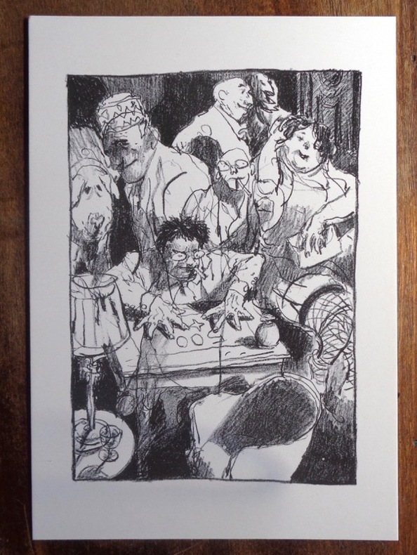
Crécy de:
Le magicien.
P.M.J éditions. Carte postale, à l'état de neuf.
書籍販売業者の参照番号
: 970
|
|
|
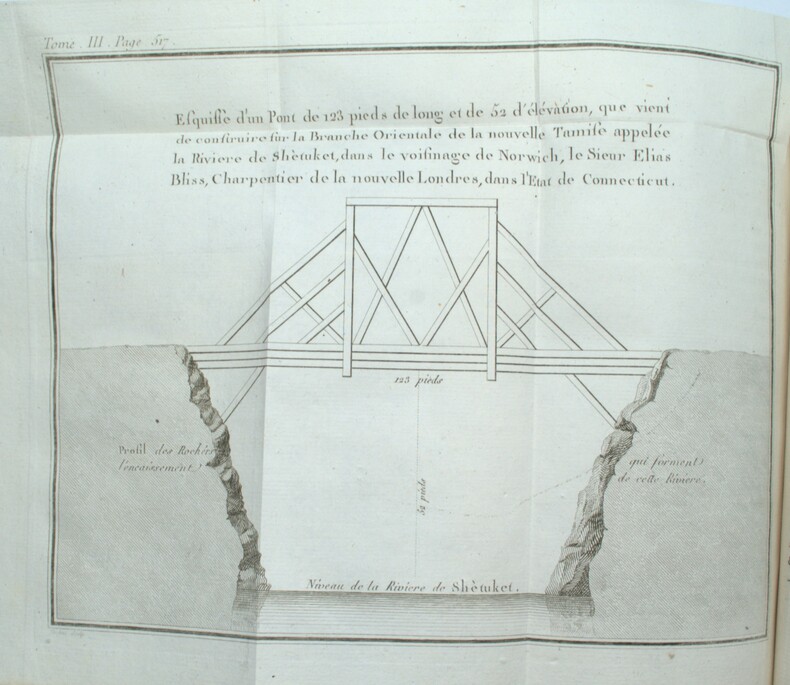
CRÉVECOEUR, (Michel Guillaume St. Jean de )
Lettres d’un cultivateur américain adressées à Wm. S on Esqr. depuis l’année 1770 jusqu’en 1786. Traduites de l’Anglois.
Paris, Cuchet, 1787. 3 vol. in-8 veau marbré, dos à nerfs ornés, p. de titre et de tomaison en mar. rouge et vert, tr. rouges (reliure de l'époque). 4ff.-xxxii-478pp-3ff., 3ff.-438pp.-5ff., 2ff.-592pp-2ff., illustrée de 3 vignettes de titre, 4 planches hors texte et 5 grandes cartes dépliantes. Qqs lég. épidermures, qqs restaurations aux coiffes et nerfs, manque de cuir en bas du second plat du tome I. Ex-libris M. Trumet, avocat. Mouillures claires par endroits. Bel exemplaire.
書籍販売業者の参照番号
: PHO-1655
|
|
|
CRÉVECOEUR, (Michel Guillaume St. Jean de )
Lettres d’un cultivateur américain adressées à Wm. S on Esqr. depuis l’année 1770 jusqu’en 1786. Traduites de l’Anglois.
A Paris, chez Cuchet, 1787. 3 volumes in-8, veau teinté vert de l’époque, dos lisse orné, pièces de titre et de tomaison maroquin rouge, tranches jaspées, menus défauts d’usage, 2 planches un peu brunies et qq. rouss. au vol.2). 4ff.-xxxii-478pp-3ff., 3ff.-438pp.-5ff., 2ff.-592pp-2ff.
書籍販売業者の参照番号
: PHO-1961
|
|
|
CS. Hammond & Co. and color Maps C. S.
Atlas of World War II: 20th Commemorative Edition
Paperback. Very Good. Softcover unpaged 7 pages paperback
書籍販売業者の参照番号
: 800008407
|
|
|
Cuban Tourist Commission
Panoramic and Monumental Map of HAVANA
Overall size is about 31 1/2" X 21". Map has some creasing and the top left corner has some crinkling. Includes a full size Map of Havana A Map of Marianao Interesting Places in Marianao Map of the Gulf of Mexico City of Havana Streets. Ships First Class with Delivery Confirmation. Ucar Garcia, S. A. paperback
書籍販売業者の参照番号
: biblio664

|
|
|
CUCCIONI Tommaso (Roma, 1790 circa – 23 agosto 1864)
Pianta Topografica di Roma
Rara pianta a proiezione verticale, orientata con il nord in alto. Incisa da Filippo Troiani per l'editore Tommaso Cuccioni. A sinistra rubrica: Indice de' principali edifizi di Roma moderna. A destra: Indice degli avanzi de' monumenti antichi posti nelle loro Regioni. "Stampata in quattro fogli. In basso notizia che cita il nome del pontefice Gregorio XVI (1830-1846), da cui la datazione al 1840 circa. Nella sua accurata rappresentazione della città il Troiani tenne certamente a riferimento la pianta del Censo edita una decina d'anni prima ma ancora di fatto attuale. In alto a sinistra dedica ad Agostino Feoli, amministratore generale della Banca Romana" (cfr. Marigliani, 2007, pp. 346-347). Acquaforte, stampata su quattro grandi fogli, tagliati, applicati su tela coeva e più volte ripiegati ad astuccio, piccole ossidazioni, per il resto in buono stato di conservazione. Bibliografia Scaccia Scarafoni (1939): n. 289; Frutaz (1962): n. 196; Marigliani (2007): pp. 346-347, n. 279. Rare vertical projection map, oriented with north at the top. Engraved by Filippo Troiani for the publisher Tommaso Cuccioni. On the left heading: Indice de' principali edifizi di Roma moderna. On the right: Indice degli avanzi de' monumenti antichi posti nelle loro Regioni. Printed in four sheets. At the bottom news that mentions the name of Pope Gregory XVI (1830-1846), hence the dating to about 1840. In its accurate representation of the city Troiani certainly held to reference the map by Census edited a decade earlier but still current. At the top left dedication to Agostino Feoli, general administrator of the Banca Romana (see Marigliani, 2007, pp. 346-347). Etching, printed on four large sheets, cut, applied on original canvas and folded several times to a case, small oxidation, otherwise in good condition. Literature Scaccia Scarafoni (1939): n. 289; Frutaz (1962): n. 196; Marigliani (2007): pp. 346-347, n. 279.

|
|
|
CUCCIONI Tommaso (Roma, 1790 circa – 23 agosto 1864)
Veduta Generale di Roma dal Gianicolo
- TERZO STATO con l'imprint della Libreria Spithöver - Terzo stato, del celebre panorama dal Gianicolo che viene attribuito alla mano di Lugi Nisi-Cavalieri (Roma XIX sec.) e Augusto Marchetti (Forli 1813 – Roma 1871) per l'editore Tommaso Cuccioni.Scrive Barbara Jatta: "L'opera non è citata dai comuni repertori e la mancanza di iscrizioni ci induce a formulare solamente delle ipotesi attributive. È noto un esemplare della stampa (Roma, BASA) che indica come editore, e committente, Tommaso Cuccioni, attivo a via Condotti n. 18. Di lui si conosce anche un piccolo panorama della città che, perfettamente corrispondente a questo in esame, seppure di dimensioni molto ridotte, reca le indicazioni A. Marchetti inc il paesaggio L. Nisi-Cavalieri inc. il Panorama. Sembra dunque possibile, vista la corrispondenza tra i due incisori, che anche la presente sia da ricondurre ai medesimi autori. […] Il Cuccioni fu anche uno dei primi e più noti fotografi romani dell'Ottocento. […] Il panorama di Roma dal Gianicolo qui esposto ha senza dubbio una stretta relazione con gli esordi della tecnica fotografica. Eseguito ad acquaforte e bulino, esso deve la sua impostazione di base all'uso di strumenti meccanici". (cfr. Barbara Jatta in Roma Veduta, p. 230).Dunque, se l'attribuzione al Nisi-Cavalieri e al Marchetti è, sebbene plausibile, puramente congetturata, la commitenza di Tommaso Cuccioni e invece certa. Fatto che ci induce ad indicarlo, in qualità di editore, commitente e fotografo, come l'autore principale di questa veduta. Della grande vedute esiste una prova di stampa, prima di gran parte dei ritocchi a bulino, che possiamo considerare un primo stato della lastra. La stesura definitiva, con ritocco a bulino e completamento della lastra, reca l'imprint "Si trova vendibile presso l'Editore Tommaso Cuccioni, Negoziante di Stampe. Roma, Via della Croce n. 88". L'indirizzo di via della Croce 88 mette anche in dubbio la datazione assegnata da Barbara Jatta all'opera (1848 circa) che potrebbe essere quindi anche precedente. In accordo con le sue note biografiche infatti (cfr. Marina Miraglia - Dizionario Biografico degli Italiani - Volume 31, 1985) il Cuccioni viene descritto gia attivo all'indirizzo di Via Condotti 18 nel prima della morte di papa Gregorio XVI (1846). Una datazione intorno al 1840, ci sembra più compatibile con le note biografiche.La terza stesura dell'opera - che qui presentiamo - reca l'imprint della Libreria Spithöver ed è probabilmente databile a dopo il 1864, anno della scomparsa di Cuccioni.Josef Spithöver (Sendenhorst, 11 oct. 1813 - Roma, 12 genn. 1892), nato in Germania, è stato un animatore della cultura romana di metà ottocento, gestendo una libreria-casa editrice. Fu anche un pioniere della fotografia.Acquaforte e bulino, stampata su tre fogli di carta databile alla seconda metà del'800, brunitura diffusa, macchie e ossidazioni sparse, strappi nel margine bianco, per il resto in buono stato di conservazione. - THIRD STATE with the imprint of the Spithöver Bookshop - Third state, of the famous panorama from the Janiculum Hill that is attributed to the hand of Lugi Nisi-Cavalieri (Rome XIX sec.) and Augusto Marchetti (Forli 1813 - Rome 1871) for the publisher Tommaso Cuccioni.Barbara Jatta writes: "The work is not mentioned by the common repertories and the lack of inscriptions leads us to formulate only attributive hypotheses. It is known a copy of the work (Rome, BASA) that indicates as publisher, and client, Tommaso Cuccioni, active in Rome, via Condotti n. 18. We also know of him a small panorama of the city that, perfectly corresponding to this one, even if of very small dimensions, bears the indications "A. Marchetti inc. il paesaggio L. Nisi-Cavalieri inc. il Panorama". It seems therefore possible, considering the correspondence between the two engravers, that also the present one is to be traced back to the same authors. [...] Cuccioni was also one of the first and most famous Roman photographers of the nineteenth century. [...] The panorama of Rome from the Janiculum Hill exhibited here has without doubt a close relationship with the beginnings of photographic technique. Carried out with etching and burin, it owes its basic approach to the use of mechanical instruments". (cf. Barbara Jatta in Roma Veduta, p. 230).Therefore, if the attribution to Nisi-Cavalieri and Marchetti is, although plausible, purely conjectured, the commission of Tommaso Cuccioni is certain. A fact that leads us to indicate him, as publisher, commissioner and photographer, as the main author of this view. Of the great view there is a proof, before most of the burin retouches, which we can consider a first state of the plate. The final issue, with the engraving additions, bears the imprint ""Si trova vendibile presso l'Editore Tommaso Cuccioni, Negoziante di Stampe. Roma, Via della Croce n. 88". The address of via della Croce 88 also puts in doubt the dating assigned by Barbara Jatta to the work (about 1848) that could be therefore also previous. In accordance with her biographical notes in fact (see Marina Miraglia - Dizionario Biografico degli Italiani - Volume 31, 1985) Cuccioni is described already active at the address of Via Condotti 18 before the death of Pope Gregory XVI (1846). A dating around 1840, seems to us more compatible with the biographical notes.The third issue of the work - which we present here - bears the imprint of the Libreria Spithöver and can probably be dated after 1864, the year of Cuccioni's death.Josef Spithöver (Sendenhorst, 11 oct. 1813 - Rome, 12 Jan. 1892), born in Germany, was an animator of Roman culture in the mid-nineteenth century, managing a bookshop-publishing house. He was also a pioneer of photography.Etching and engraving, printed on three sheets of paper datable to the second half of the nineteenth century, widespread burnishing, scattered stains and oxidations, tears in the white margin, otherwise in good condition. Roma Veduta, p. 230, n. 72; Marigliani p. 364, n. 298.

|
|
|
CUCCIONI Tommaso (Roma, 1790 circa – 23 agosto 1864)
Veduta Generale di Roma presa dal Monte Gianicolo
RARISSIMO PRIMO STATO Primo stato, del celebre panorama dal Gianicolo che viene attribuito alla mano di Lugi Nisi-Cavalieri (Roma XIX sec.) e Augusto Marchetti (Forli 1813 – Roma 1871) per l'editore Tommaso Cuccioni.Prova avanti i ritocchi a bulino nel paesaggio e nel grande albero a sinistra; nel nostro esemplare l’uso del bulino si limita alla quinta arborea in primo piano, che inquadra la terrazza del Gianicolo, mentre la città ed il paesaggio è delineato a solo contorno.Scrive Barbara Jatta: "L'opera non è citata dai comuni repertori e la mancanza di iscrizioni ci induce a formulare solamente delle ipotesi attributive. È noto un esemplare della stampa (Roma, BASA) che indica come editore, e committente, Tommaso Cuccioni, attivo a via Condotti n. 18. Di lui si conosce anche un piccolo panorama della città che, perfettamente corrispondente a questo in esame, seppure di dimensioni molto ridotte, reca le indicazioni A. Marchetti inc il paesaggio L. Nisi-Cavalieri inc. il Panorama. Sembra dunque possibile, vista la corrispondenza tra i due incisori, che anche la presente sia da ricondurre ai medesimi autori. […] Il Cuccioni fu anche uno dei primi e più noti fotografi romani dell'Ottocento. […] Il panorama di Roma dal Gianicolo qui esposto ha senza dubbio una stretta relazione con gli esordi della tecnica fotografica. Eseguito ad acquaforte e bulino, esso deve la sua impostazione di base all'uso di strumenti meccanici". Inoltre: "Del panorama esiste anche un esemplare inciso al tratto acquafortistico, non terminato con il bulino, e avantilettera (Biblioteca Apostolica Vaticana, Stampe Ashby, Miscell. Panorami 24) che reca solamente un timbro a secco con le iniziali C. F. ad oggi non identificate" (cfr. Barbara Jatta in Roma Veduta, p. 230).Dunque, se l'attribuzione al Nisi-Cavalieri e al Marchetti è, sebbene plausibile, puramente congetturata, la commitenza di Tommaso Cuccioni e invece certa. Fatto che ci induce ad indicarlo, in qualità di editore, commitente e fotografo, come l'autore principale di questa veduta. Il timbro a secco che la Jatta identifica in "C. F." a noi appare chiaramente come un "C. T."; monogramma che identifica - fuori ogni dubbio - Tommaso Cuccioni.La stesura definitiva, con ritocco a bulino e completamento della lastra, reca l'imprint "Si trova vendibile presso l'Editore Tommaso Cuccioni, Negoziante di Stampe. Roma, Via della Croce n. 88". L'indirizzo di via della Croce 88 mette anche in dubbio la datazione assegnata da Barbara Jatta all'opera (1848 circa) che potrebbe essere quindi anche precedente. In accordo con le sue note biografiche infatti (cfr. Marina Miraglia - Dizionario Biografico degli Italiani - Volume 31, 1985) il Cuccioni viene descritto gia attivo all'indirizzo di Via Condotti 18 nel prima della morte di papa Gregorio XVI (1846). Una datazione intorno al 1840, ci sembra più compatibile con le note biografiche.Acquaforte e bulino, stampata su tre fogli di carta databile alla prima metà del'800, con margini, in eccellente stato di conservazione. Rarissimo. VERY RARE FIRST STATE First state, of the famous panorama from the Janiculum Hill that is attributed to the hand of Lugi Nisi-Cavalieri (Rome XIX sec.) and Augusto Marchetti (Forli 1813 - Rome 1871) for the publisher Tommaso Cuccioni.A proof state, before the burin retouches in the landscape and in the large tree on the left; in our exemplar the use of the burin is limited to the foreground, which frames the terrace of the Janiculum hill, while the city and the landscape is outlined with the etching only.Barbara Jatta writes: "The work is not mentioned by the common repertories and the lack of inscriptions leads us to formulate only attributive hypotheses. It is known a copy of the work (Rome, BASA) that indicates as publisher, and client, Tommaso Cuccioni, active in Rome, via Condotti n. 18. We also know of him a small panorama of the city that, perfectly corresponding to this one, even if of very small dimensions, bears the indications "A. Marchetti inc. il paesaggio L. Nisi-Cavalieri inc. il Panorama". It seems therefore possible, considering the correspondence between the two engravers, that also the present one is to be traced back to the same authors. [...] Cuccioni was also one of the first and most famous Roman photographers of the nineteenth century. [...] The panorama of Rome from the Janiculum Hill exhibited here has without doubt a close relationship with the beginnings of photographic technique. Carried out with etching and burin, it owes its basic approach to the use of mechanical instruments". In addition: "Of the panorama there is also an exemple engraved on the etching, not finished with the burin, and before the letter (Biblioteca Apostolica Vaticana, Stampe Ashby, Miscell. Panorami 24) that bears only a mark with the initials C. F. to date unidentified" (cf. Barbara Jatta in Roma Veduta, p. 230).Therefore, if the attribution to Nisi-Cavalieri and Marchetti is, although plausible, purely conjectured, the commission of Tommaso Cuccioni is certain. A fact that leads us to indicate him, as publisher, commissioner and photographer, as the main author of this view. The mark that Barbara Jatta identifies in "C. F." clearly appears to us as a "C. T."; monogram that identifies - beyond any doubt - Tommaso Cuccioni.The final issue, with burin retouching and completion of the plate, bears the imprint "Si trova vendibile presso l'Editore Tommaso Cuccioni, Negoziante di Stampe. Roma, Via della Croce n. 88". The address of via della Croce 88 also puts in doubt the dating assigned by Barbara Jatta to the work (about 1848) that could be therefore also previous. In accordance with her biographical notes in fact (see Marina Miraglia - Dizionario Biografico degli Italiani - Volume 31, 1985) Cuccioni is described already active at the address of Via Condotti 18 before the death of Pope Gregory XVI (1846). A dating around 1840, seems to us more compatible with the biographical notes.Etching and engraving, printed on three sheets of paper datable to the first half of the 19th century, with margins, in excellent condition. Very rare. Roma Veduta, p. 230, n. 72; Marigliani p. 364, n. 298.

|
|
|
Cuff Samuel H. & James McNaughton maps & Robert Bright maps
The Face of the War 1931-1942 with 73 maps
Julian Messner Inc. Good in Fair dust jacket. 1942. First Edition; First Printing. Hardcover. Book has edgewear toning to covers and pages FFEP has name inked and a bird stamp attached small faint soil spot to bottom page ends; DJ has 4 quarter-sized chips and several smaller chips small tears and tiny nicks w/creasing rubbing to edges light toning bottom corner of front flap is clipped but price remains at top; DJ in protective Brodart cover; 290 pages . Julian Messner Inc. hardcover
書籍販売業者の参照番号
: M2679

|
|
|
CULBERTSON Ely
"Le compte de points Culbertson au bridge; 4-3-2-1 amélioré et simplifié avec la nouvelle règle de 3 et 4."
Paris, Editions Prisma, 1954. 12 x 19, 240 pp., broché, bon état.
書籍販売業者の参照番号
: 35267
|
|
|
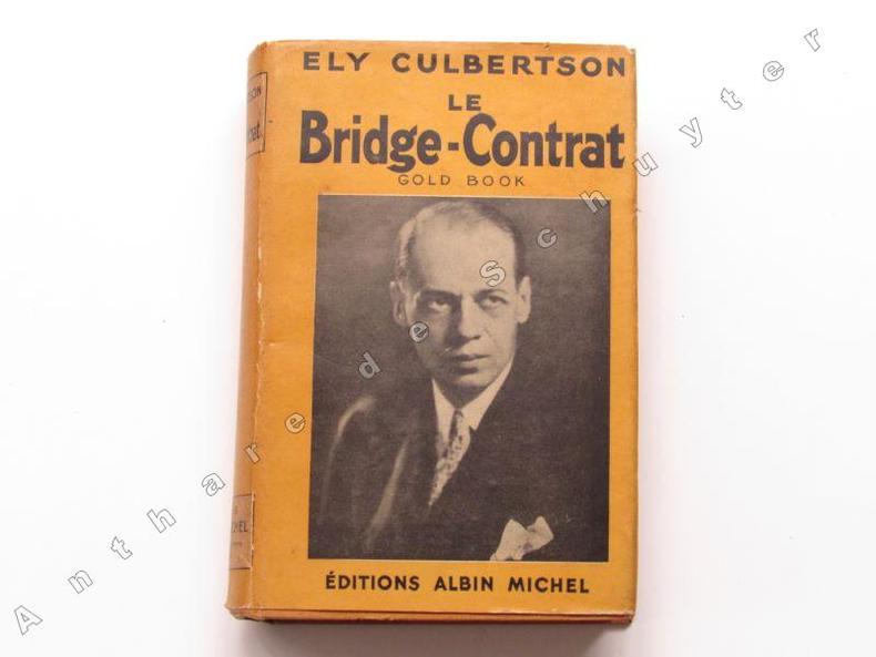
CULBERTSON, Ely
LE BRIDGE CONTRAT (GOLD BOOK)
1938 Albin Michel, Paris, 1938. Un volume in 12° relié toile jaune d'or de l'éditeur, jaquette illustrée, 608 pages, bon état.
書籍販売業者の参照番号
: 3680
|
|
|
CULBERTSON Ely (COUTELAN Pierre, ROMANET B.)
Memento du Bridge Contrat, 1955.
Paris, Albin Michel, 1955. 11 x 16, 77 pp., cartonnage d'édition imprimé, bon état.
書籍販売業者の参照番号
: 24253
|
|
|
Cunnersdorf:
Cunnersdorf bei Frankfurt an der Oder. "Plan der Bataille, welche d. 12.August 1759 von der Russisch Kayserlich und Königlich Preussischen Armee bey Cunnerstdorf ohnweit Frankfurt an der Oder geliefert worden." Schlachtenplan von Cunnersdorf, links mit Legende. Kupferstich mit farbigen Truppenaufstellungen aus "Neues Kriegs-Theater ..." No.24.
Format: 18 x 29,5 cm. *Leicht gebräunt, insgesamt gut erhalten. Landkarten de
|
|
|
Cunningham John T.; maps Homer Hill
New Jersey : America's main road
Garden City New York : Doubleday & Comapny 1966. 1966. Good. xx 326 ; illustrated ; beige and blue cloth no dustjacket ; ex-lib stamps label date due pocket ; Contents: Geology molder of destiny -- Before the white sails showed -- New Amsterdam and New Sweden -- The time of two Jerseys -- Power of the purse -- Portrait of 100 years -- Slow strides to independence -- Revolution's crossroads -- Founding a nation -- towpath and iron horse -- Invasion of skills -- Search for a conscience -- Northernmost of the border states -- The backbone turns iron -- Revolution at the crossroads -- Ideas money and muscles -- The huddled masses -- Victorian interlude -- Of the people -- The yanks are coming -- Safe for democracy -- Bullets babies and moving vans -- Where to find New Jersey. ; G Garden City, New York : Doubleday & Comapny, 1966. hardcover
書籍販売業者の参照番号
: 005766

|
|
|
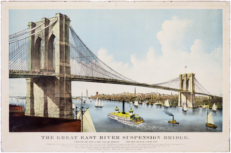
CURRIER (Nathaniel) & IVES (James Merritt).
[NEW YORK/PONT de BROOKLYN] The Great East River Suspension Bridge. Connecting the cities of New York and Brooklyn. View from Brooklyn, looking West.
New York, Currier & Ives, 1886. 550 x 835 mm, contrecollée sur carton fort.
書籍販売業者の参照番号
: LBW-6972
|
|
|
Curator: BESTE GÜRSU.
Beyoglu Belediyesi 155. Yil Beyoglu Bellegi Arsiv Sergisi. Efemera sergisi. 2-25 Agustos 2012. [Exhibition catalogue].
New English Paperback. Pbo. Large 8vo. (22 x 22 cm). In Turkish. [42] p. Color and b/w ills. Beyoglu Belediyesi 155. Yil Beyoglu Bellegi Arsiv Sergisi. Efemera sergisi. 2-25 Agustos 2012. [Exhibition catalogue].
|
|
|
Curator: BESTE GÜRSU.
Maps of Beyoglu.= Beyoglu haritalari. [Exhibition catalogue]. 04-15 December 2012.
New English Paperback. Pbo. Large 8vo. (21 x 21 cm). In English and Turkish. 42 p. Color and b/w ills. Beyoglu - Pera (Constantinople) from incunabulum to present day. Maps of Beyoglu.= Beyoglu haritalari. [Exhibition catalogue]. 04-15 December 2012.
|
|
|
Curtis William
ORIGINAL HAND-COLOURED ENGRAVING - Ilex chinensis FROM CURTIS'S BOTANICAL MAGAZINE - Plate No. 2043 dated 1819
W. Curtis 1819. A fine original hand-coloured copper-engraved plate from this famous work size approx. 14 x 24cm. The condition is very good colours bright and fresh paper bright minimal offsetting supplied without accompanying text and without mount. The quality of the illustrations in the Botanical Magazine is outstanding both accurate and decorative the colours vibrant. William Curtis 1746-1799 was a trained apothecary living in London although his passion was for natural history particularly plants and insects. He maintained a large well-stocked garden and began the publication of the Botanical Magazine in February 1787 which has gone on to become the most famous and influential botanical publication of its type; it is still published today making it the longest running scientific periodical of all time. Curtis edited the first 13 volumes and was then succeeded by John Simms 1800-1826 William Jackson Hooker 1827-1865 and Joseph Dalton Hooker 1865-1904 the current editor of the magazine is Martyn Rix. The fine illustrations were by many artists including Sydenham Edwards William Graves James Sowerby John Curtis William Jackson Hooker W.H. Fitch J. N. Fitch Matilda Smith Lillian Snelling and Stella Rose Craig. The plates were hand-coloured up to 1948! all being copper engravings to around 1840 and then stone or zinc lithography until the introduction of color printing in 1948. References: Blunt;The Art of Botanical Illustration Great Flower Books pp. 156 - 157 Nissen BPI 2350 Staflue 1290. Please Note: we do not break books for plates nor do we condone this practice. Our plates have either been purchased loose or have come from books that are so defective or incomplete that they are irreparable. First Edition. Very Good. W. Curtis unknown
書籍販売業者の参照番号
: 020307

|
|
|
CUSSON L.
Nouveau plan de la ville de La-Roche-sur-Yon. Plan rural au verso.
Une feuille 55x78 cm en pochette.
|
|
|
CYCLING & MOTORING MAP OF EXETER DISTRICT
Bacon's Cycling and Motoring Map of Exeter District[Cycling and Touring] Map of 60 Miles South of London, including Worthing, Brighton, Hastings, etc.. Scale Half an Inch to One Mile. NEAR FINE COPY
8vo., folding map on cloth, coloured in outline, measuring 15 x 20 inches (approx. 38 x 51 cms) folding in 18 panels to 5.25 x 3.5 inches (approx. 13 x 9 cms); red limp cloth wrappers lettered in black, radial corners, a near fine copy. With trade advertisements. SCARCE IN THIS CONDITION.
|
|
|
Cyprus Dept of Lands & Forests
Cyprus and the Turkish Invasion
Nicosia: Cyprus Dept of Lands & Forests 1975 Map of Cyprus showing the areas invaded by Turkey in 1974 and the economic losses in the occupied territory. April 1975. Size: 20" x 13". First Thus. Very Good. Map. Cyprus Dept of Lands & Forests unknown
書籍販売業者の参照番号
: 11916
|
|
|
Cyprus Press & Information Office
Cyprus 1995
Nicosia: Cyprus Tourism Organisation 2004 Map coloured "Compiled and drawn by the Department of Lands and Surveys. First ed. 1986 Revised March 2004." Scale 1: 350.000. Rev Ed. Folded Map. New. Map. Cyprus Tourism Organisation paperback
書籍販売業者の参照番号
: 16333
|
|
|
Cyprus Tourism Organisation
A Visitor's Map of Cyprus
Large fold-out map. Scale 1: 350000.[40 x 63 cm; folded to 11 x 23 CM.] Map
|
|
|
Cyril Illustrated by 82 Photo's 50 Line drawings 8tables 2 Maps Aldred
The Egyptians
N . Y.: Frederick A. Praeger 1963 1963. Unknown Binding. Good. Good paperback. Previous owner's name on end paper pages are otherwise clean and unmarked. Covers show edge wear with rubbing and creases.; 100% Satisfaction Guaranteed! Ships same or next business day! N . Y.: Frederick A. Praeger, 1963 unknown
書籍販売業者の参照番号
: 1110050106
|
|
|
Czech Republic Streetwise Maps Prague
Streetwise Prague Map - Laminated City Center Street Map of
11. unknown
書籍販売業者の参照番号
: hallmark-b4rfv ISBN : 1886705208 9781886705203

|
|
|
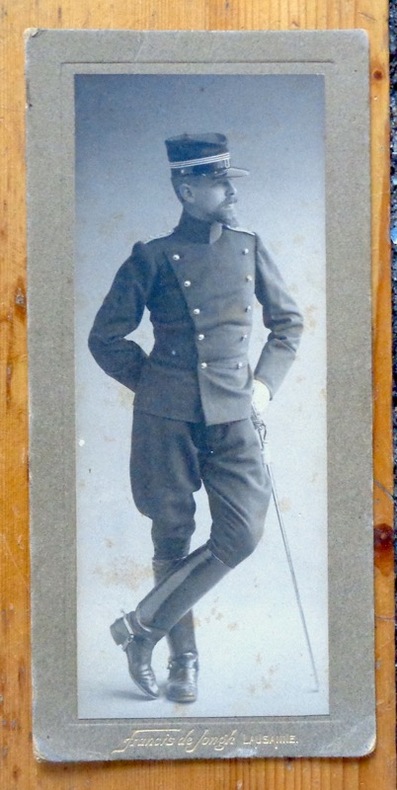
Cérenville B. de :
Portrait photographique en pied.
Lausanne, Francis de Jongh, [1914]. Photographie au format 8 x 17 cm., nom du photographe doré au bord inférieur. Légèrement frottée, avec quelques rousseurs.
書籍販売業者の参照番号
: 8157
|
|
|
Cüstrin:
Cüstrin. "Plan der Belagerung der Stadt und Vestung Cüstrin durch die Kaiserl. Russische Armee im Monath August An.1758." Stadtplan von Cüstrin. Kupferstich mit farbigen Truppenaufstellungen. Aus "Neues Kriegs-Theater", Supplement No. 4.
Format: 18 x 29,5 cm. *Leicht gebräunt, insgesamt gut erhalten. Landkarten de
|
|
|
D M Ramsden maps and illustrations by Marie Hartley
From Stainmore to the Tees
The Dalesman Publishing Company Clapham via Lancaster 1948. First Edition. Softcover. Very Good Condition/No Dust Jacket. Illustrator: Marie Hartley. Cream card covers are a little darkened sound binding light foxing to half-title page clean pages. Contains black and white illustrations. No dust-jacket. Illustrator: Marie Hartley. Quantity Available: 1. Shipped Weight: under 1 kg. Pictures of this item not already displayed here available upon request. Inventory No: 51319121059. The Dalesman Publishing Company paperback
書籍販売業者の参照番号
: 51319121059

|
|
|
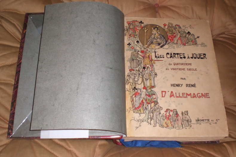
D'Allemagne Henri René
Les Cartes A Jouer du Quatorzième Au Vingtième Siècle
Hachette Et Cie Editeur - Paris - 1906 - Edition Originale - Deux gros volumes épais- Complet - Volume 1 :504 pages, volume 2 :640 pages .Exceptionnel ouvrage contenant 3200 reproductions de cartes à jouer ,956 en couleurs,12 planches hors texte acquaréllées main ,25 phototypies,116 enveloppes de cartes à jouer ,340 vignettes et vues diverses, tables des matières complètes en fin de chaque volume - Serpentes protégeant bien les gravures - Volumes in folio non rogné demi veau rouge ,dos à nerfs ,couvertures conservées ,intérieur très frais,pas de rousseur .
書籍販売業者の参照番号
: 9812
|
|
|
D'Anville Jean Baptiste Bourguignon (1697-1782)
Plan de Rome Ancienne Dressé pour L'intilligence de l'histoire Romaine de Mr. Rollin
Pianta di Roma antica disegnata da Jean-Baptiste Bourguignon D'anville per la Storia romana del Rollin. Histoire romaine depuis la fondation de Rome jusqu'à la bataille d'Actium di Charles Rollin divenne una tra le opere più durature dedicate alla storia romana, impreziosita da alcune carte geografiche inserite nell'Atlas de géographie ancienne pour servir à l'intelligence des oeuvres de Rollin: gravé d'après les cartes originales de d'Anville. Incisione in rame, consuete pieghe di carta, in ottimo stato di conservazione. Pianta di Roma antica disegnata da Jean-Baptiste Bourguignon D'anville per la Storia romana del Rollin. Histoire romaine depuis la fondation de Rome jusqu'à la bataille d'Actium di Charles Rollin divenne una tra le opere più durature dedicate alla storia romana, impreziosita da alcune carte geografiche inserite nell'Atlas de géographie ancienne pour servir à l'intelligence des oeuvres de Rollin: gravé d'après les cartes originales de d'Anville. Incisione in rame, consuete pieghe di carta, in ottimo stato di conservazione.

|
|
|
D'Anville, [Jean-Baptiste Bourgignon].
Golfe Persique. Dressé en 1758 et publié en 76 par le Sr. d'Anville, Prém[ier] Géogr[aphe] du Roi. [Paris], 1776.
Engraved map. 282 x 440 mm (image). 311 x 465 mm (sheet). The famous nautical chart by the French geographer and cartographer d'Anville (1697-1782), encompassing the Arabian Gulf from Basra to the Straits of Hormuz. Although the southwestern part of the Gulf is poorly explored, various Gulf cities are identified, including "Julfar" (Ras al-Khaimah), "Mekehoan" (Umm Al Quwain), "Kalba", and "Ras-ol Lima". The city of "Al Katif" is clearly identified. The Qatar Peninsula is entirely absent, but the island of Bahrain is noted (though misaligned), and the coastline between Bahrain and Abu Dhabi is marked as an "entirely unknown coast". - With several contemporary manuscript additions in ink, including "Gatar" (south of Bahrain) and "Kouait" (Kuwait), as well as a few later notes in pencil in the Bahrain area. Old shelfmarks on the reverse. Slightly toned. David Rumsey Map Collection 2603.025. Al-Qasimi (2nd ed.), p. 236.
|
|
|
D'ANVILLE, Jean-Baptiste Bourguignon / Jamaica
JAMAICA: 'Isle de la Jamaique.' - Original engraved map from 'Jean-Baptiste Bourguignon d'ANVILLE: Atlas portatif, vol. II'.
[Paris, Bibliothèque des dames, 1786.]. 1 sheet, with a decorated titlefield; Ca. 20,9 x 23,7 cm (will be shipped flat, unfolded).
書籍販売業者の参照番号
: 1505010565xbvk
|
|
|
D'ANVILLE, Jean-Baptiste Bourguignon: [de Anville]
Asia Minor - Turkey / Türkei / Türkiye: TURQUIE D'ASIE, DRESSÉE SUR LES OBSERVATIONS ASTRONOMIQUES. - Original engraved map from 'Jean-Baptiste Bourguignon d'ANVILLE: Atlas portatif, vol. II'.
Paris, Bibliothèque des dames, 1786. 1 sheet, with a decorated titlefield. Ca. 21,2 x 23,9 cm (will be shipped flat, unfolded).
書籍販売業者の参照番号
: 18071018xbvk
|
|
|
D'ANVILLE, Jean-Baptiste Bourguignon: [de Anville]
L'AMÉRIQUE MÉRIDIONALE, divisée en ses principaux États' (Latin-America/Mittelamerika). - Original engraved map from 'Jean-Baptiste Bourguignon d'ANVILLE: Atlas portatif, vol. II'.
Paris, Bibliothèque des dames, 1786. 1 sheet, with a decorated titlefield; ca. 21 x 24 cm (will be shipped flat, unfolded).
書籍販売業者の参照番号
: 1409151357xbvk
|
|
|
D'Aubigne J. H. Merle; Gill John trans.
THE STORY OF THE REFORMATION
London: George Routledge and Sons 1862. 575 pages. Original half leather binding with matching marble boards and endpapers spine label and gilt decoration to the spine five raised bands good with some general wear and rubbing. Contents clean and tight hinges cracked but carefully repaired no inscriptions unmarked no annotation. A very good copy. First Edition. Leather Bound. Very Good/No Dust Jacket. Sm 8vo. George Routledge and Sons Hardcover
書籍販売業者の参照番号
: 020995

|
|
|
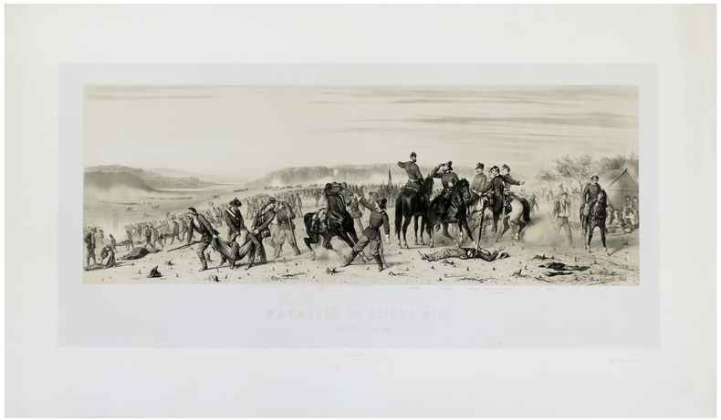
d'ORLEANS (François).
[GUERRE DE SÉCESSION/VIRGINIE] Bataille de Gaine's Mill. Virginie (27 juin 1862).
[1862]. 366 x 740 mm.
書籍販売業者の参照番号
: LBW-5489
|
|
|
D'Orta, Piemme and Enrika
Together in Pompeii
No marks or inscriptions. No creasing to covers or to spine. A lovely clean very tight copy with bright unmarked boards and no bumping to corners. Protected in fully-removable proprietary plastic sleeve. 64pp. Tucked in is a large fold-out plan of Pompeii. Travel guide with 110 coloured illustrations.

|
|
|
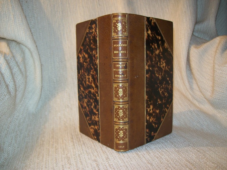
D*** L Amateur
ACADEMIE UNIVERSELLE DES JEUX. 3e édition.
Paris Corbet Aîné 1842. In-12 2 feuillets non chiffrés 2-401pp. Demi maroquin havane à larges coins signés, dos à nerfs, compartiments finement dorés, "Cercle du Commerce, Epernay" frappé au centre, tête dorée, relié vers 1880. Page 401 raccourcie sans perte de texte et contrecollée sur un feuillet blanc. Bel exemplaire sans aucune rousseur, dans une élégante reliure de la fin du XIXe siècle.
書籍販売業者の参照番号
: GITe691
|
|
|
D. B. A. Thompson; Colin Baxter
Scotland: Land of Mountains
No marks or inscriptions. A lovely clean very tight copy with bright unmarked boards and no bumping to corners. Dust jacket not price clipped or marked or torn or creased with minor sunning around spine. 128pp. Beautiful book on the wildness of Scotland's mountains with the superb photographs from Colin Baxter. We do not use stock photos, the picture displayed is of the actual book for sale. Every one of our books is in stock in the UK ready for immediate delivery.

|
|
|
Daddy, Bernard . [et al.] (eds.)
Wideworld: GCSE Geography Review
4 volume set, over 80 pages, illustrated, includes articles on the Kobe Earthquake, coastal pollution, ozone depletion and Pakistan. eng
|
|
|
Daen, Leonid ; Poznyak, Pavel & Cherp, Mark
Kiev Travel Guide
No marks or inscriptions to contents. No creasing to covers or to spine. A very clean very tight copy with bright vinyl boards, faint ink mark to rear and no bumping to corners. 224pp. Travel guide to Soviet Kiev with an emphasis on Soviet propaganda and history. Scarce in the UK.

|
|
|
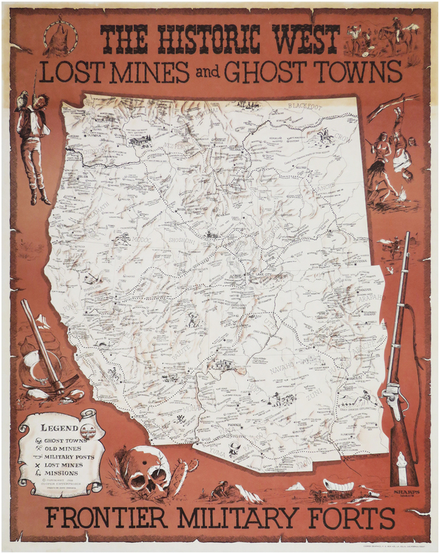
DAGOSTA (Andy).
The historic West. Lost mines and ghost towns, frontier military forts.
La Jolla, Cooper Enterprises, 1968. 705 x 547 mm.
書籍販売業者の参照番号
: LBW-8142
|
|
|
DAHLBERG, ERIK.
Giöksholm. J.v.d. Aveelen Sc.
Holmiæ (Stockholm), 1702. 22,5x36,5 cm. Kobberstukket prospekt fra Svecia Antiqva et Hodierna. Et par smårifter i marginer, intet tab.
書籍販売業者の参照番号
: 28094
|
|
|
 検索結果のメールを受信する
 PDFファイルの検索結果をダウンロード
 RSSフィード


