|
|
|
FOUCHÉ Agent-voyer en chef.-
Carte routière de l'arrondissement de Dieppe dressée sous l'administration de M. le Baron E. Leroy.-
Service vicinal. Département de la Seine-Inférieure. 1858. Grande et belle carte (ca 720 x 1000mm) entoilée, plusieurs fois rempliée sous cartonnage grenat titré or et orné d'un décor rocaille à froid. Couverture un peu passée sinon bel exemplaire.
Bookseller reference : ORD-4052
|
|
|
FOUCHÉ Agent-voyer en chef.-
Carte routière de l'arrondissement de Neufchâtel dressée sous l'administration de M. le Baron E. Leroy.-
Service vicinal. Département de la Seine-Inférieure. 1860. Grande et belle carte (ca 740 x 1000mm) entoilée, plusieurs fois rempliée sous cartonnage grenat titré or et orné d'un décor rocaille à froid. Couverture un peu passée sinon bel exemplaire.
Bookseller reference : ORD-4053
|
|
|
FOUCHÉ Agent-voyer en chef.-
Carte routière du Canton de Bellencombre dressée sous l'administration de M. le Baron E. Leroy.-
Service vicinal. Département de la Seine-Inférieure. Arrondissement de Dieppe. 1870. Grande et belle carte (ca 666 x 1000mm) entoilée, plusieurs fois rempliée sous cartonnage grenat titré or et orné d'un décor à froid. Couverture un peu passée sinon bel exemplaire.
Bookseller reference : ORD-4054
|
|
|
FOUCHÉ Agent-voyer en chef.-
Carte routière du Canton de Longueville dressée sous l'administration de M. le Baron E. Leroy.-
Service vicinal. Département de la Seine-Inférieure. Arrondissement de Dieppe. 1870. Grande et belle carte (ca 670 x 1000mm) entoilée, plusieurs fois rempliée sous cartonnage grenat titré or et orné d'un décor à froid. Couverture un peu passée sinon bel exemplaire.
Bookseller reference : ORD-4055
|
|
|
FOUCHÉ Agent-voyer en chef.-
Carte routière du Département de la Seine Inférieure dressée sous l'administration de M. Ernest Leroy.-
Service vicinal. Département de la Seine-Inférieure. 1852. Grande et belle carte (ca 680 x 1000mm) entoilée, plusieurs fois rempliée, muette et sans couverture (170 x 228mm).
Bookseller reference : ORD-4056
|
|
|
Fournier, F lix Alfaro
Playing Cards: General History From Their Creation to The Present Day Set Vol. I and II
Vitoria, , Heraclio Fournier, , 1982/1988 Hardcover with dusjacket, 2 vols in slipcase, 285 x 215 mm, volume 1 : 343 pp, volume 2 : 112 pp with 4,000 illustrations in full color and 2,000 descriptions of packs. Text in English. ISBN 9788485074112.
Bookseller reference : 62447
|
|
|
Frabetti Pietro
Carte nautiche italiane dal XIV al XVII secolo conservate in Emilia Romagna. Archivi e Biblioteche Pubbliche.
(Carte nautiche - Cartografia - Marina) In 8°, cartoncino editoriale a stampa, pp. XXI,(3),187,(1), con XL tavole in b/n fuori testo (riproduzioni fotografiche di carte nautiche). Prefazione di Osvaldo Baldacci. ''Nuovo Repertorio delle Carte Nautiche Italiane Manoscritte conservate in Italia (Secoli XIII-XVII)''. Dedica autografa dell'Autore sulla prima carta bianca. Ben conservato.
|
|
|
FRABETTI Pietro - RIZZI Amedeo -
La collezione delle antiche carte geografiche - Il Museo delle navi.
Bologna, Tip. Compositori, (1950) 8vo brossura, pp. 183 con num. tav. n.t.

|
|
|
Frabetti Pietro.
Carte Nautiche Italiane dal XIV al XVII Secolo Conservate in Emilia-Romagna.
Firenze, Olschki,1978. In 4°pp.XXI+187n.+XL tavv.f.t. bross.orig. intonso.
|
|
|
Frabetti, Pietro
Carte nautiche italiane dal XIV al XVII secolo conservate in Emilia-Romagna.
cm. 20 x 27,5, xxiv-188 pp. con 40 tavv. f.t. Nuovo repertorio delle carte nautiche italiane manoscritte conservate in Italia (secc. XIII-XVII) 700 gr. xxiv-188 p.
|
|
|
Fraisse , Ad.
Affiche: Tir Fédéral à Fribourg en 1881. Èchelle de 1:200. Dressé par Ad. Fraisse, Architecte, Fribourg 30 Décembre 1880.
Lith. Lang & Cie. Fribourg. 1881, 48x65 cm Affiche lithographique avec plan d’une partie de la Ville (Schönberg) d’ou le Tir Fédéral a eu lieu, petite déchirure en bas a droite. Avec 3 vues: ‘Cantine - Pavillon des Prix - Stand dressé par Ad. Fraisse, Architecte Fribourg 30 déc. 1880’ 1 feuille.
Bookseller reference : 942.1aaf
|
|
|
Fraisse , Ad.
Affiche: Tir Fédéral à Fribourg en 1881. Èchelle de 1:200. Dressé par Ad. Fraisse, Architecte, Fribourg 30 Décembre 1880.
Lith. Lang & Cie. Fribourg. 1881, 48x65 cm Affiche lithographique avec plan d’une partie de la Ville (Schönberg) d’ou le Tir Fédéral a eu lieu, Avec 3 vues: ‘Cantine - Pavillon des Prix - Stand dressé par Ad. Fraisse, Architecte Fribourg 30 déc. 1880’ 1 feuille.
Bookseller reference : 127124aaf
|
|
|
FRANCASTEL PIERRE
La Pologne pittoresque .
1934 Bernard Arthaud éditeur 1934 état d'usage 206 pages avec 235 héliogravures in 8 broché dos fatigué coins légèrements cornés traces de scotch sur les 2 plats exemplaire défraichi .
Bookseller reference : 7503
|
|
|
Francavilla Franco, Zecchi Rodolfo e altri
Repertorio cartografico italiano. 1: geografia fisica e geomorfologia. 2: pedologia
4 volumi, 22x25 cm (album), custodie editoriali contenenti cartelle con anelli; numerose carte geografiche con riferimenti bibliografici a fronte

|
|
|
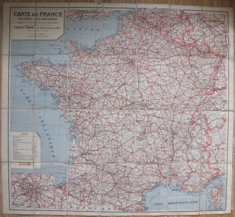
FRANCE CARTOGRAPHIE
Taride - Nouvelle carte de France. Echelle 1/1.300.00e.
Paris, Taride, s.d. (ca 1920) 85 x 100 cm. Carte sur toile pliée. Tirage en 3 couleurs.
Bookseller reference : 81576
|
|
|
France. Service de documentation et de cartographie geographiques Centre national de la recherche scientifique France
Me�moires et documents Volume 18 Leather Bound
2019. Leather Bound. New. Leather Binding on Spine and Corners with Golden Leaf Printing on round Spine. Reprinted in 2019 with the help of original edition published long back. This book is printed in black & white sewing binding for longer life Printed on high quality Paper re-sized as per Current standards professionally processed without changing its contents. As these are old books we processed each page manually and make them readable but in some cases some pages which are blur or missing or black spots. We expect that you will understand our compulsion in these books. We found this book important for the readers who want to know more about our old treasure so we brought it back to the shelves. Hope you will like it and give your comments and suggestions. Lang: - fre Vol: - Volume 18 Pages 745. EXTRA 10 DAYS APART FROM THE NORMAL SHIPPING PERIOD WILL BE REQUIRED FOR LEATHER BOUND BOOKS. FOLIO EDITION IS ALSO AVAILABLE. Volume 18 hardcover
Bookseller reference : LB1111003242838
|
|
|
Francesco Bertelli (fl. 1594-1629).
Libera trasposizione dal Theatro delle città d’Italia con nova aggiunta. Variante del titolo: - Theatro
<br/> STATO: NUOVO.<br/> TITOLO: Libera trasposizione dal Theatro delle città d’Italia con nova aggiunta. Variante del titolo: - Theatro delle città d'Italia con le sue figure intagliate in rame & descrittioni di esse in questa terza impressione accresciuto di nova aggiunta di molte figure e dichiarationi.<br/> AUTORE: Francesco Bertelli (fl. 1594-1629).<br/> EDITORE: Istituto Geografico Militare<
|
|
|
Francesco Bonasera
La cartografia storica territoriale delle Marche (1561-1851)
Collana "Raccolta di studi sui beni culturali ed ambientali delle Marche", 9. Un volume di 109 pagine, brossura editoriale illustrata. Dimensioni: 17x24 cm. Minime tracce d'uso alla brossura, per il resto ottime condizioni. Numerose illustrazioni in b/n nel testo.
|
|
|
FRANCIS MILLET ROGERS
L'enseignement supérieur aux Etats Unis.
Services Américains d'Informations, Aperçu Sommaire, 1952, 68 pages, exemplaire de bibliothèque, brochure in 8, bon état.
Bookseller reference : 10189
|
|
|
FRANCO Giacomo (Venezia o Urbino 1550 - Venezia 1620)
La Impresa del Isola et Citta di Cadis di spagna fatta alli 2 luglio 1596...
Acquaforte e bulino, 1596, firmata in lastra in basso con l’imprint Franco fecit. Si tratta di una carta d’occasione, nata per documentare il primo assedio di Cadice. La presa di Cadice (o primo assedio di Cadice), fu uno scontro navale combattuto nella baia di Cadice, in Spagna, dal 30 giugno al 15 luglio 1596, nell'ambito della guerra degli ottant'anni. Le truppe inglesi di Robert Devereux, II conte di Essex e una grande flotta anglo-olandese comandata da Charles Howard, I conte di Nottingham, col supporto delle Province Unite olandesi, mosse contro la città spagnola di Cadice. Per la mancanza di organizzazione degli spagnoli, gli anglo-olandesi incontrarono ben poca resistenza. Per negare agli aggressori le loro prede di guerra, gli spagnoli incendiarono le navi della loro flotta ancorata nella baia di Cadice quando compresero di aver ormai perduto; le forze attaccanti sbarcarono, catturarono, saccheggiarono e bruciarono la città e fecero diversi ostaggi tra i cittadini più illustri che vennero portati in Inghilterra in attesa del pagamento del loro riscatto. Rarissima. Bibliografia J. Halle, Newe Zeitungen: Relationen, Flugschriften, Flugblätter, Einblattdrucke von 1470 bis 1820 (1967): p. 158, n. 667. Etching and engraving, 1596, signed in plate at bottom with the imprint Franco fecit. This is a second-hand chart, created to document the first siege of Cadiz. The capture of Cadiz (or first siege of Cadiz), was a naval battle fought in the Bay of Cadiz, Spain, from June 30 to July 15, 1596, as part of the Eighty Years' War. The English troops of Robert Devereux, 2nd Earl of Essex and a large Anglo-Dutch fleet commanded by Charles Howard, 1st Earl of Nottingham, with the support of the United Dutch Provinces, moved against the Spanish city of Cadiz. Due to the lack of organization of the Spanish, the Anglo-Dutch met little resistance. In order to deny the attackers their war booty, the Spaniards set fire to the ships of their fleet anchored in the Bay of Cadiz when they realized they had lost; the attacking forces landed, captured, looted and burned the city and took several hostages among the most distinguished citizens who were brought to England to await the payment of their ransom. Bibliography J. Halle, Newe Zeitungen: Relationen, Flugschriften, Flugblätter, Einblattdrucke von 1470 bis 1820 (1967): p. 158, no. 667.

|
|
|
FRANCO Giacomo (Venezia o Urbino 1550 - Venezia 1620)
Venetia
In alto al centro, a caratteri grandi ed interrotto dall’isola di Murano, è inciso il titolo: VENETIA. Nella parte inferiore della tavola sono incise le vedute di Piazzetta S. Marco e del ponte di Rialto. Ai lati della vignetta centrale si trova una legenda alfanumerica di 203 rimandi (I-XXXV e 1-170, ma sono mancanti i numeri XIV e 66) distribuita su sei colonne. I primi 34 nomi, contrassegnati con numeri romani, sono intitolati NOME DE IRII PRINCIPALI, una descrizione dei canali della città. Seguono TUTTE le contrade overo parochie, 169 rimandi contrassegnati con numeri arabi a contrade o parrocchie e chiese. Sulla tavola sono presenti alcune indicazioni toponomastiche. Orientazione nei quattro lati al centro con il nome dei venti: TRAMONTANA, OSTRO, LEVANTE, PONENTE, il nord è in alto. Pianta prospettica della città, anonima, priva di data ed indicazioni editoriali nella sua prima stesura, finora sconosciuta alla letteratura e qui per la prima volta pubblicata. Si tratta di una replica della pianta incisa da Giacomo Franco nel 1597; come nota giustamente Cassini sono presenti nella tavola “perfino certi preziosismi calligrafici così cari al Franco”. Si potrebbe pensare, pertanto, anche ad un’ulteriore versione dello stesso autore. In basso al centro sono rappresentate le vedute di San Marco e del Ponte di Rialto, già presenti nella pianta di Bernardo Salvioni (1597) che l’autore di questa lastra potrebbe forse aver esaminato. La datazione dell’opera, quindi, è sicuramente successiva al 1597. Schulz fa notare come siano indicati sia il toponimo del Redentore che delle Zitelle, ma manchi poi il disegno dell’edificio sulla pianta. La matrice conosce una prima ristampa (che finora era considerata come il primo stato della lastra) per i torchi della tipografia di Francesco Valegio e Catarin Doino. Questa tiratura può essere ricondotta al 1611 circa, anno dell’unica incisione datata nota della tipografia. Il terzo stato della lastra reca solo il nome del Valegio; tale tiratura deve essere successiva al 1614, anno in cui terminò il sodalizio editoriale con il Doino. Nel 1622 la lastra fu usata dall’editore Nicolò Misserini, che la inserì in un foglio volante composto dalla pianta (corpus centrale), da due strisce incise raffiguranti 94 dogi (da Paolo Lucio Anafesto a Francesco Contarini) recanti l’imprint Francesco Vallegio et forma in Venetia, e da un foglio tipografico che fornisce delle indicazioni storico-geografiche sulla città. Entrambi gli imprint del Valegio, sia quello nella pianta che quello nella tavola raffigurante i dogi, sono leggibili ma chiaramente abrasi, segno che le due matrici erano ormai passate di mano. La tavola dei dogi era stata prodotta dal Valegio durante il regno di Leonardo Donà (1606-12) e pertanto la lastra fu aggiornata con l’aggiunta dei ritratti degli ultimi cinque dogi in basso a destra. Proprio dall’ultimo doge ritratto, Francesco Contarini (1623-24) si ricava la datazione di questa edizione, sicuramente anteriore al 1625. La sola lastra della pianta fu poi ristampata nel corso del XVII secolo da Stefano Scolari, Domenico Lovisa e Giovanni Antonelli. Esemplare nel quinto stato di sette descritto in Bifolco-Ronca, con l’indirizzo di Stefano Mozzi Scolari aggiunto in basso a destra. Tiratura databile tra il 1640 e il 1660. Acquaforte e bulino, impressa su carta vergata coeva, con margini, in ottimo stato di conservazione. Magnifica e rara pianta prospettica di Venezia. Bibliografia Bifolco-Ronca, Cartografia e topografia italiana del XVI secolo, tav. 1273, V/VII; Bury (2001): p. 181, n 118; Cassini (1971): n. 30; Moretto (2001): nn. 53, 110; Nagler, (1911): XVIII, p. 154; Schulz (1970): p. 61, nn. 60-63. At the top center, in large letters and interrupted by the island of Murano, is engraved the title: VENETIA. In the lower part of the table are engraved views of Piazzetta S. Marco and the Rialto bridge. On the sides of the central vignette there is an alphanumeric legend of 203 cross-references (I-XXXV and 1-170, but the numbers XIV and 66 are missing) distributed over six columns. The first 34 names, marked with Roman numerals, are entitled NOME DE IRII PRINCIPALI, a description of the city's canals. This is followed by ALL contrade overo parochie, 169 cross-references marked with Arabic numbers to contrade or parishes and churches. On the table there are some toponymic indications. Orientation in the four sides in the center with the name of the winds: TRAMONTANA, OSTRO, LEVANTE, PONENTE, the north is at the top. Perspective plan of the city, anonymous, without date and editorial indications in its first issue, so far unknown to the literature. It is a replica of the map engraved by Giacomo Franco in 1597; as Cassini rightly notes, "calligraphic preciousnesses so dear to Franco" are present in the map. One could think, therefore, also to a further version of the same author. In the lower center are represented the views of San Marco and the Rialto Bridge, already present in the plan of Bernardo Salvioni (1597) that the author of this plate could perhaps have examined. The dating of the work, therefore, is certainly after 1597. Schulz points out that both the toponym of the Redentore and of the Zitelle are indicated, but the drawing of the building on the plan is missing. The plate knows a first reprinting (which until now was considered as the first state of the plate) for the press of the typography of Francesco Valegio and Catarin Doino. This printing can be traced back to about 1611, the year of the only known dated engraving of the printing house. The third state of the plate bears only the name of Valegio; this issue must be later than 1614, the year in which the publishing partnership with Doino ended. In 1622 the plate was used by the publisher Nicolò Misserini, who inserted it in a flyleaf composed of the plan (central corpus), two engraved strips depicting 94 doges (from Paolo Lucio Anafesto to Francesco Contarini) bearing the imprint Francesco Vallegio et forma in Venetia, and a typographical sheet that provides historical and geographical information about the city. Both Valegio's imprints, both the one on the plan and the one on the table depicting the doges, are legible but clearly abraded, a sign that the two plates had already changed hands. The table of the doges had been produced by Valegio during the reign of Leonardo Donà (1606-12) and therefore the plate was updated with the addition of the portraits of the last five doges in the lower right corner. It is precisely from the last doge portrayed, Francesco Contarini (1623-24) that we derive the date of this edition, certainly prior to 1625. The only plate of the map was then reprinted during the seventeenth century by Stefano Scolari, Domenico Lovisa and Giovanni Antonelli. Our example is of fifth state of seven described in Bifolco-Ronca, with the address of Stefano Mozzi Scolari added at lower right. Circulation dated between 1640 and 1660. Etching and engraving, impressed on contemporary laid paper, with margins, in excellent condition. Magnificent and rare perspective map of Venice. Bibliografia Bifolco-Ronca, Cartografia e topografia italiana del XVI secolo, tav. 1273, V/VII; Bury (2001): p. 181, n 118; Cassini (1971): n. 30; Moretto (2001): nn. 53, 110; Nagler, (1911): XVIII, p. 154; Schulz (1970): p. 61, nn. 60-63.

|
|
|
FRANCO GIUSEPPE.
Prontuario delle distanze chilometriche delle ferrovie del regno con le tariffe vigenti pel trasporto dei viaggiatori ordinari, impiegati, militari, ecc. e dei bagagli.
Roma, Stabilimento tipo litografico del Genio Civile, gennaio 1909. (mm. 195). Tela editoriale con titolo al dorso (lieve macchia ai lati dei piatti). pp. XVII, (2), 563(1), 1 c.b. Con due grandi carte geografiche f.t. più volte ripiegate che formano la “ Carta generale delle strade ferrate del regno d’Italia “. Ottimo esemplare.
|
|
|
Franco Paloscia a cura di
L'Italia dei grandi viaggiatori
In 4°. Legatura in tela, con titolo in oro al dorso. Sovraccoperta illustrata con alette. Pagine in buonissimo stato, ricche di tavole illustrate a colori e in nero, nel testo e fuori. A cura di Franco Paloscia.Scritti di Carlo Bernari, Cesare de Seta, Atanasio Mozzillo, Georges Vallet. Numero pagine 157.
|
|
|
Franco Paloscia a cura di
Venezia dei grandi viaggiatori
In-4 (cm. 30.60), tela editoriale, sovracoperta editoriale illustrata, pp. 191, (1), con illustrazioni, nel testo, in bianco e nero ed a colori. Testi di Alvise Zorzi, Emanuele Kancegff, Marilla Battilana, etc.
|
|
|
FRANCOIS BALSAN
Etrange Baloutchistan.
Société Continentale d'Editions Modernes Illustrées, collection Connaissance de l'Asie, édition originale de 1969, 366 pages, exemplaire de bibliothèque ( tampon de la Société de Géographie de Lille), 64 planches hors texte en héliogravure + 8 planches hors texte couleurs + 20 cartes et croquis, grand in 8 reliure cartonnée et toilée rouge ornée d'un dragon noir et or, titre auteur et édition lettrage or, bon état.
Bookseller reference : 10295
|
|
|
FRANCOIS CALI
Provence enchantée.
Arthaud, 1966, 220 pages + 1 carte + 215 photographies NB et 4 couleurs, grand in 8 reliure éditeur cartonnée avec jaquette illustrée, couverture d'Yves Brayer, état d'usage, quelques usures et frottements sur le dos et les coins.
Bookseller reference : 12371
|
|
|
FRANCOIS GARRIGUE
Maroc enchanté.
Arthaud, 1969, 239 pages, grand in 8 reliure éditeur cartonnée et toilée en très bon état, avec jaquette illustrée en état d'usage, quelques usures et pliures.
Bookseller reference : 9996
|
|
|
FRANCOIS GEBELIN
Les châteaux de la Loire.
Alpina, la France illustrée, 1962, bon état, 60 pages, in8.
Bookseller reference : 5300
|
|
|
FRANCOIS GEBELIN
Versailles.
Alpina, 1964, 156 pages, in 8 reliure cartonnée et toilée rouge, bon état, avec jaquette en état moyen, petites déchirures et manques.
Bookseller reference : 8338
|
|
|
FRANCOIS PINARDEL
Géographie (cours moyen).
1950 Editions L'Ecole, années 50, 76 pages, cahier d'écolier broché (format A4), bon état général, coins cornés.
Bookseller reference : 16957
|
|
|
FRANCOIS PONTHIER
Le harpon.
Le Livre de Poche, 1968, in 12 format poche, 317 pages, bon état.
Bookseller reference : 7620
|
|
|
Francois, Andre
Histoire De La Carte a Jouer
, Serg Freal;, 1974 Hardcover with dusjacket, 355 pages, Illustrated. Texte en Francais.
Bookseller reference : 62432
|
|
|
FRANCOISE XENAKIS
Mouche-toi Cléopatre.
J-C.Lattès, 1986, 272 pages, in 8 broché, état d'usage, coins légèrement cornés, couverture salie et tachée, quelques frottements, pliures et usures.
Bookseller reference : 12588
|
|
|
FREDERIC KIESEL
Légendes d'Ardenne et de Lorraine.
Duculot, préface de Georges Sion, 1974, 192 pages, in 8 broché, état correct, quelques frottements et usures.
Bookseller reference : 10062
|
|
|
Frederick E. Bangs
Outlines of Map Drawing with Diagrams Founded on Parallels and Meridians
<p>Good HC no DJ. Staple-bound under paper covered boards backed with cloth. Scuffed lightly soiled covers have damp stains along edges; tightly bound; foxing on end papers; slight damp stain on front end paper; light clean interior; some staple rust at centerfold map; supple leaves. 12mo unpaged 44 pp. Cf OCLC #43627996.</p> Chicago: Interstate Publishing Co hardcover
Bookseller reference : 17710
|
|
|
Freisel, Evyatar
Atlas of Modern Jewish History: Revised from the Hebrew Edition.
30x23.5 cm. 159 pages. Gilt hardcover with dust jacket. Cover corners and spine edges slightly rubbed and bumped. Else in good condition. PLEASE NOTE: This item is overweight. We may ask for extra shipping costs.
|
|
|
Freitag, U
Kartographische Konzeptionen. Beiträge z. theoret. u. prakt. Kartographie 1961-1991.
Berlin, Selbstvlg. d. FU, 1992. 4°. M. 8 farb. Taf. u. 98 Abb. 5 Bl., 343 S. (Berliner Geowiss. Abh. C 13).
Bookseller reference : 621946
|
|
|
Frescura B. (Prof.)
Guida degli Stati Uniti nell'America del Nord con relativa nuova legge sull'immigrazione (3 marzo 1903 N. 162)
cartine

|
|
|
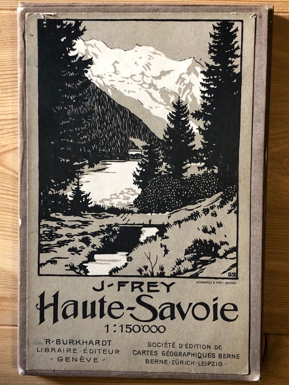
FREY J. / BURKHARDT. R
HAUTE SAVOIE ( Carte 1/ 150.000 ème )
carte éditée par Kummerly et Frey. imprimerie Burkhardt à Genève. Société d'Edition de cartes géographiques Berne - Zurich - Leipzig. carte couleur entoilée époque 68 cm x 82 cm. plusieurs fois repliée. titre avec l'Arve et le Mont Blanc. BEL ETAT.
Bookseller reference : 2694
|
|
|
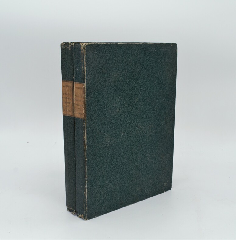
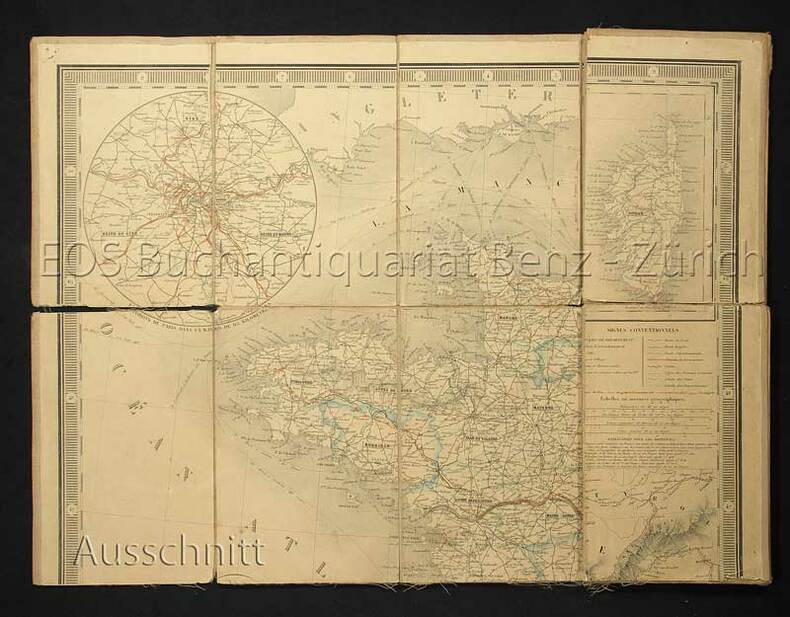
FREYCINET, Louis-Claude de Saulces de.
Voyage autour du Monde, entrepris par ordre du roi, sous le ministère et conformément aux instructions de S. Exc. M. le vicomte du Bouchage, secrétaire d'état au département de la marine, exécuté sur les corvettes de S.M. l'Uranie et la Physicienne, pendant les années 1817, 1818, 1819 et 1820 .
Paris ,Imprimerie Royale pour Pillet Aine,1826 , 2 volumes in-4 (320x250mm) ,cartonnage d’attente non rogné d’époque , étiquette avec auteur et titre au dos, de 6ff-732pp, pagination continue , illustré de 3 planches H.T. (détachées) , quelques rousseurs aux planches,
Bookseller reference : PHO-1307
|
|
|
Friolo,Riccardo.
I nodi geostorici delle rotte circumasiatiche.
<br/> TITOLO: I nodi geostorici delle rotte circumasiatiche. <br/> AUTORE: Friolo,Riccardo.<br/> CURATORE: Intr.e cura di Giovanna Motta, traduzione di Giordano Altarozzi.<br/> EDITORE: Società Geografica Italiana <br/> DATA ED.: 2005,<br/> COLLANA: Coll.Memorie della Società Geografica Italiana, vol.LXXVIII.<br/> EAN: 9788888692234
|
|
|
Frison-Roche Roger
Mission Ténéré [Algeria, Niger, Ciad]
110 illustrazioni

|
|
|
Frison-Roche Roger
Popoli cacciatori dell'Artico
2 carte 41 fotografie di Pierre Tairraz

|
|
|
Frogerays Fréderic
Guide indicateur et historique de Genève ancienne et moderne. Deuxième édition.
16°, mm 190x115, pp. (2), XIX, (1), 167, (11) di pubblicità . Brossura editoriale con due piccoli strappetti agli angoli, altrimenti eccellente, con carte fresche e in barbe; una pianta della città malamente applicata alla prima pagina di introduzione che copre parzialmente la prima parte del testo. Seconda edizione, assai rara. Bibliographie Raisonnee de l'Histoire de Geneve, n. 209 per l'edizione del 1866. ID 6466

|
|
|
FROME E.
Outline of the Method of Conducting a Trigonometrical Survey for the Formation of Geographical and Topographical Maps and Plans. With the most useful Problems in Geodesy and Practical Astronomy. [Revised by Captain C. Warren]. FIRST WARREN EDITION IN FULL MOROCCO
8vo., Fourth Edition, with 16 engraved plates (a number double-page), and 115 woodcuts and numerous tables in the text; handsomely bound in red full morocco, back gilt with five raised bands, second and fourth compartments lettered and ruled in gilt, all other compartments tooled and ruled in gilt, uncut, original catalogue preserved, a most attractive copy ideal as a gift or for presentation. With 56pp publisher's catalogue bound in at end. Written for the use of junior officers of the Royal Engineers and those of the Honourable East India Company's Service, Frome's extensive treatise was first published from REE Chatham in 1839. Its value as a standard text was swiftly recognised in both military and civilian sectors and the third edition was exhausted by 1862. This is the fourth (first Warren) edition, considerably expanded as well as revised. A lovely copy.
|
|
|
Frutaz Pietro Amato (A cura di)
Le carte del Lazio. Volume primo: Testo, Volume secondo Tavole dal sec. III d.c. al 1816-1824
3 Voll. In-4 (Cm 37,5 x 27), pp. 263 - 484 tavole bianco nero molte delle quali a doppia pagina contenute nei volumi secondo e terzo , legature editoriali piena tela con titoli e fregi in oro al piatto anteriore. Una millimetrica abrasione angolo inferiore primo tomo, diversamente COME NUOVO

|
|
|
FRÉJUS.-
Cartes d'Etat-Major au 1/20000. Carroyage kilométrique. Projection Lambert. Levées en 1913, révisées en 1931.-
Dressées, héliogravées et publiées par le Service Géographique de l'Armée en 193. Paris. Institut Géographique National. (1931). Huit feuilles d'environ 52 x 71 cm, cartes d'environ 42 x 56 cm. Courbes de relief colorées. Complet. Menus défauts mais bon état. (2).
Bookseller reference : ORD-17139
|
|
|
Frémin, A(ntoine)-R(emy)
Nouvelle carte physique et routière de la France. Toutes les routes de poste, royales et départementales, avec les distances comptées en kilomètres d'un lieu a un autre. Les chemins de fer éxécutés et en construction ainsi que les canaux navigables et les pincipales rivières.. Dressé par A.R. Fremin, Geogrpahe, d'après les cartes de la marine, celles de ponts et chaussées et des postes.
Paris, Augte. Logerot, 1853. Lithogr. Karte auf Leinen aufgezogen. Blattformat: 70 x 93 cm. + Wichtig: Für unsere Kunden in der EU erfolgt der Versand alle 14 Tage verzollt ab Deutschland / Postbank-Konto in Deutschland vorhanden +, 479D
Bookseller reference : 479DG

|
|
|
Frémin, A(ntoine)-R(emy):
Nouvelle carte physique et routière de la France. Toutes les routes de poste, royales et départementales, avec les distances comptées en kilomètres d'un lieu a un autre. Les chemins de fer éxécutés et en construction ainsi que les canaux navigables et les pincipales rivières.. Dressé par A.R. Fremin, Geogrpahe, d'après les cartes de la marine, celles de ponts et chaussées et des postes.
Paris, Augte. Logerot, 1853. Lithogr. Karte auf Leinen aufgezogen. Blattformat: 70 x 93 cm.
Bookseller reference : 479DG
|
|
|
FUAT SEZGIN.
Piri Reis and the Pre-Columbian discovery of the American continent by Muslim seafarers.
New English Paperback. Pbo. Oblong large 8vo. (22 x 22 cm). In English. Color and b/w ills. 68 p. Piri Reis and the Pre-Columbian discovery of the American continent by Muslim seafarers.
|
|
|
 Receive by email
 Download as PDF document
 RSS feed


