|
|
|
[MACARTNEY]
Atlas de Macartney - Voyage dans l'intérieur de la Chine et en Tartarie, fait dans les années 1792,1793 et 1794, par Lord Macartney, Ambassadeur du Roi d'Angleterre auprès de l'Empereur de Chine; Rédigé sur les papiers de Lord Macartney, sur ceux du Commodore Erasme Gower, et des autres Personnes attachées à l'Ambassade; Par Sir Georges Staunton, de la Société Royale de Londres, Secrétaire de l'Ambassade d'Angleterre, et Ministre plénipotentiaire auprès de l'Empereur de Chine; Traduit de l'anglais, avec des notes, par J. Castera.
A Paris, Chez F. Buisson, Imprimeur-Libraire, An XII (1804). 1 volume in-4, reliure ancienne demi-basane, plats cartonnés fortement frottés, intérieur propre, comportant une collection de 37 Planches et 4 Cartes dessinées à Londres, et gravées en taille-douce par Tardieu l'aîné, bon état.
书商的参考编号 : 11328
|
|
|
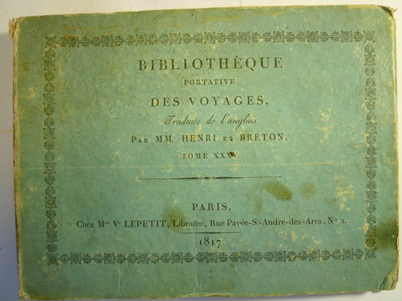
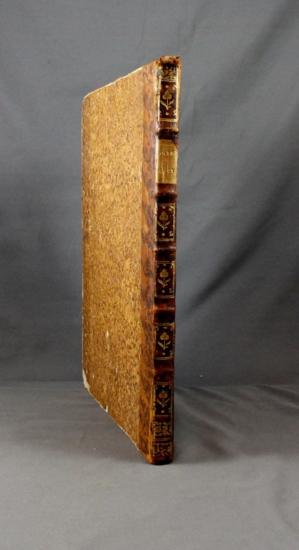
[MACARTNEY] [ATLAS]
Atlas de Macartney
Paris, Chez M.me V.e Lepetit, Libraire, 1817. 1 volume in-12 oblong, couverture cartonnée d'éditeur salie (soiled covers), enrichi d'une carte dépliante de la Chine et de 22 petites gravures en noir et blanc (1 map of China and 22 small prints), quelques rousseurs (some foxing), état correct.
书商的参考编号 : 3602
|
|
|
[MACARTNEY] [ATLAS]
Voyage dans l'intérieur de la Chine et en Tartarie, fait dans les années 1792,1793 et 1794, par Lord Macartney, Ambassadeur du Roi d'Angleterre auprès de l'Empereur de Chine; Rédigé sur les papiers de Lord Macartney, sur ceux du Commodore Erasme Gower, et des autres Personnes attachées à l'Ambassade; Par Sir Georges Staunton, de la Société Royale de Londres, Secrétaire de l'Ambassade d'Angleterre, et Ministre plénipotentiaire auprès de l'Empereur de Chine; Traduit de l'anglais, avec des notes, par J. Castera. 5 volumes de texte et 1 Atlas in quarto
A Paris, Chez F. Buisson, Imprimeur-Libraire, An XII (1804). 5 volumes de texte, reliure plein veau, plats ornés de liserés, dos ornés, très beaux exemplaires et 1 volume d'atlas in quarto, reliure ancienne plein veau, comportant une collection de 37 Planches et 4 Cartes dessinées à Londres, et gravées en taille-douce par Tardieu l'aîné, excellent état. REMISE POSSIBLE POUR ACHAT DIRECT - DISCOUNT OFFERED FOR DIRECT SALE - PLEASE CONTACT THE BOOKSELLER FOR MORE INFORMATION
书商的参考编号 : 5582
|
|
|
[MAJOR] HALIT ZIYA [TÜRKKAN] (?), (Turkish cartographer, scientist, specialist of cadaster), (1886-1966).
[MANUSCRIPT HAND-COLOURED MAP OF SYRIA - PALESTINE - TRANSJORDAN] Suriye - Filistin - Transjordan.
Very Good Turkish Original manuscript color map of Middle East including Syria, Palestine and Transjordan. Signed by cartographer. 28x20 cm. In Turkish (with Latin letters). The Mapping Department, which moved to Ankara from Istanbul after the Independence War, settled in the Attar Basi Khan in Koyunpazari and the press section also started its studies in the building which is the Art School in Ulus today. In 1924, the department, which is still inside the General Directorate Garrison, moved to the hut-shaped buildings with single floor between the Military Sewinghouse and the General Directorate. On the other hand, the production of maps and plans, which were to be used in development services carried out in parallel to the revolutions starting with the declaration of the Republic and following each other, was considered to be based on a legal arrangement. Because of the necessity of an urgent legal arrangement, the bill of law concerning to the General Directorate of Mapping, whose preparations were initiated by Lieut. Gen. M. Sevki (Ölçer) who knew the importance of the subject, was sent to the Ministry of Defense at the beginning of 1925. After the approval of Ministry of Defense, the bill, which was sent to the Prime Ministry, was discussed in the Council of Ministers and presented to the Grand National Assembly of Turkey. As a result; the Mapping Department was re-organized as the General Directorate of Mapping affiliated with the Ministry of Defense with the law bearing the number 657 on May 2, 1925 in order to do all mapping works and meet the needs of maps and plans of all ministries, institutions and organizations. [.] The first application of photogrammetry was made in Kayas, Ankara with the Wild Autograph plotting apparatus which was purchased in that year. Captain Ömer Kadri and Captain Niyazi came back from their photogrammetry education in Germany. Major Halit and Major Nüzhet were sent to France for photogrammetry education and Captain Ishak and Captain Bahri were sent to Germany. Captain Ahmet (Denkmen) and Captain Ömer Kadri attended the Congress of Photogrammetry assembled in Berlin. (Source: The Illustrated History Of Turkish Cartography). Halid Ziya was born in Izmir, Tire. He went to Istanbul and continued to Hendese-i Mülkiye and Engineer Mekteb-i Âlîsi for seven years. After starting with "Aydin Province Umur-i Nafia Third Class Engineering", Halid Ziya Bey, who continued to work as a deputy chief engineer on 14 March 1910, left Aydin and returned to Istanbul after continuing this duty for about six and a half months. As a teacher, he taught Accounting, Algebra, Geometry, and Topography at Halkali Ziraat Mekteb-i Âlîsi and Darussafaka. Halid Ziya Bey, who was appointed as a teacher of Hendese and Cosmography in Kabatas High School, started to practice the profession of engineering and cadastral, which was his main specialty in 1327. After the First World War, the Istanbul Government started its activities in order to capture and neutralize Halid Ziya Bey and his friends. Upon the harsh measures taken, Halid Ziya Bey had to live as a fugitive in the Hasirci Mountains of Eskisehir for a while with the armed force attached to him. Halid Ziya Bey, who was involved in the movement in Anatolia until the end of the National Liberation Struggle, returned to his engineering duty after the proclamation of the Republic and was included in the cadastral works again. In 1925, Halid Ziya Bey was appointed as the Head of the Science Committee of the new cadastre organization. He wrote 5 books on cadastre, photogrammetry, trigonometry, and cadastral tools in 1928 and 1929. In addition, as a result of personal work in 1928, the road between the provincial division of the Republic of Turkey with cities has prepared a comprehensive map to show up in the forest and mining. (Source: Kadastro ne idi, nedir, ne olacaktir, Kadioglu - Yildirir. From Preface.). No scale.
|
|
|
[MAP of OTTOMAN BALKANS].
[MAP of OTTOMAN PROVINCE of BALKANS-ALBANIA] 52 Ipek (Peja). 53 Yakoh. 59 Akola. 60 Iskodra (Shkodra).
Very Good Turkish, Ottoman (1500-1928) Original color map on cloth. Oblong: 67x75 cm. In Ottoman script. Folded originally. A very detailed map. Scale: 1:210.000. Shows Shkodra Lake, its shores, Bog Mountains, Karadag (Montenegro), Iakoh, Has etc. [MAP of OTTOMAN PROVINCE of BALKANS-ALBANIA] 52 Ipek (Peja). 53 Yakoh. 59 Akola. 60 Iskodra (Shkodra).
|
|
|
[MAP of OTTOMAN PROVINCE of DIYAR-I BEKR].
[MAP of OTTOMAN PROVINCE of DIYAR-I BEKR] Diyarbakir Vilâyeti.
Very Good Turkish, Ottoman (1500-1928) Original color map. Folded. Very good. Large oblong 8vo. (21 x 26 cm). In Ottoman script. [MAP of OTTOMAN PROVINCE of DIYAR-I BEKR] Diyarbakir Vilâyeti. Province of Diyarbekir in Southeast Anatolia and its around. Many sandjaks and provinces with their detailed place names. Scale: 1/500.000.
|
|
|
[MAP of OTTOMAN PROVINCE of DIYAR-I BEKR].
[MAP of OTTOMAN PROVINCE of DIYAR-I BEKR] Diyarbakir Vilâyeti.
Very Good Turkish, Ottoman (1500-1928) Original color map. Folded. Very good. Large oblong 8vo. (21 x 26 cm). In Ottoman script. [MAP of OTTOMAN PROVINCE of DIYAR-I BEKR] Diyarbakir Vilâyeti. Province of Diyarbekir in Southeast Anatolia and its around. Many sandjaks and provinces with their detailed place names. Scale: 1/1.500.000.
|
|
|
[MAP of OTTOMAN PROVINCE of EASTERN ROUMELI].
[MAP of OTTOMAN PROVINCE of EASTERN ROUMELI] Rumeli-yi Sarkî Vilâyeti, Bulgaristan Eyâleti, Edirne Vilâyeti, [Trakya], Selânik Vilâyeti. [East Roumeli, Salonica, Adrianople provinces; Old Zagra Sandjak, Bulgarian State].
Very Good Turkish, Ottoman (1500-1928) Original color map. Folded. Very good. Large oblong 8vo. (21 x 26 cm). In Ottoman script. [MAP of OTTOMAN PROVINCE of EASTERN ROUMELI] Rumeli-yi Sarkî Vilâyeti, Bulgaristan Eyâleti, Edirne Vilâyeti, [Trakya], Selânik Vilâyeti. [East Roumeli, Salonica, Adrianople provinces; Old Zagra Sandjak, Bulgarian State]. Scale: 1/1.500.000. Ottoman Provinces in the Balkan Peninsula.
|
|
|
[MAP of OTTOMAN PROVINCE of ERZURUM].
[MAP of OTTOMAN PROVINCE of ERZURUM] Erzurum Vilâyeti.
Very Good Turkish, Ottoman (1500-1928) Original color map. Folded. Very good. Large oblong 4to. (19 x 37 cm). In Ottoman script. [MAP of OTTOMAN PROVINCE of ERZURUM] Erzurum Vilâyeti. Province of Erzurum of east Anatolia and its around. Many sandjaks and provinces with their detailed place names. Scale: 1/1.500.000.
|
|
|
[MAP of OTTOMAN PROVINCE of KONIA].
[MAP of OTTOMAN PROVINCE of KONIA] Konya Vlâyeti and around; Burdur, Isparta, Teke sandjaks, Hüdavendigâr Province Tozlu Ova, Tuz Gölü etc.
Very Good Turkish, Ottoman (1500-1928) Original color map. Folded. Very good. Oblong 4to. (21 x 42 cm). In Ottoman script. [MAP of OTTOMAN PROVINCE of KONIA] Konya Vlâyeti and around; Burdur, Isparta, Teke sandjaks, Hüdavendigâr Province Tozlu Ova, Tuz Gölü etc. Scale: 1/500.000.
|
|
|
[MAP of OTTOMAN PROVINCE of SIVAS].
[MAP of OTTOMAN PROVINCE of SIVAS] Sivas Vilâyeti, Trabzon Vilâyeti, Tokat Sancagi. [Sivas and Trabzon Provinces, Tokat Sandjak].
Very Good Turkish, Ottoman (1500-1928) Original color map. Folded. Very good. Large oblong 8vo. (26 x 26 cm). In Ottoman script. [MAP of OTTOMAN PROVINCE of SIVAS] Sivas Vilâyeti, Trabzon Vilâyeti, Tokat Sancagi. [Sivas and Trabzon Provinces, Tokat Sandjak]. Scale: 1/1.500.000.
|
|
|
[MAP of OTTOMAN PROVINCE of TREBIZOND].
[MAP of OTTOMAN PROVINCE of TREBIZOND] Trabzon Vilâyeti, Trabzon Sancagi, Canik Sancagi, Sivas Vilâyeti. [Provinces of Trabzon and Sivas; Canik and Trebizond Sandjak].
Very Good Turkish, Ottoman (1500-1928) Original color map. Folded. Very good. Obblong 4to. (21 x 38 cm). In Ottoman script. Scale:: 1/500.000. [MAP of OTTOMAN PROVINCE of TREBIZOND] Trabzon Vilâyeti, Trabzon Sancagi, Canik Sancagi, Sivas Vilâyeti. [Provinces of Trabzon and Sivas; Canik and Trebizond Sandjak]. Black Sea at north.
|
|
|
[MAP of OTTOMAN SALONIQUE].
[MAP of OTTOMAN SALONICA -THESSALONIKI-] Selânik Vilâyeti.
Very Good Turkish, Ottoman (1500-1928) Original color map. Folded. Very good. Large oblong 8vo. (21 x 26 cm). In Ottoman script. [MAP of OTTOMANT SALONICA -THESSALONIKI-] Selânik Vilâyeti. Ottoman Greece. Scale: 1/1.500.000. It shows Thessaloniki and its around. Manastir Vilayat, At north Kosovo, Siroz Sandjak etc.
|
|
|
[Maroc] – Collectif.
Maroc. Atlas historique, géographique et économique.
Horizons de France, 1935, in-4°, 96 pp, introduction du Résident général Henri Ponsot, préface par J. Gotteland, nombreuses illustrations dont certaines en couleurs de Théophile-Jean Delaye et Stéphane Lamarche, 15 cartes en noir et en couleurs, plans et graphiques, cartonnage papier simili-maroquin bleu vif de l'éditeur, vignette représentant un méhariste, titre et frise d'encadrement dorés au 1er plat, dos toilé noir avec titre doré, bon état
书商的参考编号 : 114270
|
|
|
[MAUGENDRE, Adolphe et LEPAGE, Henri].
Vues pittoresques de Nancy et de ses environs. 31 très jolies lithographies en couleur de Maugendre.
Bel exemplaire en joli coloris conserve dans sa condition d’époque. Nancy, Wiener (ainé) fils, s.d. [c. 1840-1850]. In-4 oblong de 1 titre-frontispice, 120 pp. de texte imprimées sous la forme de deux colonnes par page, 1 planche sur double-page, 30 planches lithographiées en couleurs à pleine page, 1 gravure en noir, 1 plan dépliant de Nancy. Relié en percaline rouge de l’éditeur, encadrement de filets estampés à froid autour des plats, titre frappé or au centre, dos lisse. Reliure de l’époque. 243 x 322 mm.
书商的参考编号 : LCS-18527

|
|
|
[MEDECINE] - MCMINN - HUTCHINGS - LOGAN (R.M.H. - R.T. - B.M.)
Anatomie de la tête et du cou, atlas photographique en couleurs d'anatomie humaine.
Lausanne, Éditions André Delcourt, 1990; in-4, 224 pp., broché. Ouvrage d'anatomie à destination des neurologues, illustré par des photos très réalistes. Très bon état.
|
|
|
[MILITARY PRINTINGHOUSE].
[MAP of HELLESPONT & GALLIPOLI] [Map of Hellespont, Gallipoli Peninsula, Suvla Bay, Seddülbahir and Tenedos].
Very Good Turkish, Ottoman (1500-1928) Original color map. 65,5x63 cm. In Ottoman script. This rare and decorative Gallipoli map including Hellespont, Gallipoli Peninsula, Suvla Bay, Seddülbahir, and Tenedos, the places of Gallipoli Aar in 1915 (Dardanelles Campaign) during World War 1, separated two map views. Seddulbahir and Suvla Bay at north and Straight, Peninsula, and its shores with Tenedos (now Bozcaada) at the southwest of the map. It's a very detailed and rare map printed with the series of "History of the Dardanelles Campaign" after the seven years of war. The Gallipoli campaign, also known as the Dardanelles campaign, the Battle of Gallipoli or the Battle of Çanakkale (Turkish: Çanakkale Savasi, or, Muharebâti), was a military campaign in the First World War that took place on the Gallipoli peninsula (Gelibolu in modern Turkey), from 17 February 1915 to 9 January 1916. The Entente powers, Britain (with Anzacs), France, and Russia, sought to weaken the Ottoman Empire, one of the Central Powers, by taking control of the Turkish straits.
|
|
|
[Miller, Franz Xaver; Kindermann; Atlas von Innerösterreich; Privileg; Nachdruck; Raubdruck]. - [Franz II. (I.), Kaiser]
?Kaiserl. königl. Privilegium. Wir Franz der Zweyte [...] Bekennen öffentlich mit diesem Briefe [...]; daß Uns der Buchhändler und Buchbinder zu Grätz in Unserm Herzogthume Steyermark, Franz Xav. Miller [... ], wienach er mit vielen Kosten und grosser Genauigkeit einen sogenannten Innerösterreichischen Atlas verfertigen ließe, und mit der [...] Bitte, womit wir zur Verhütung des zu befürchtenden Nachdruckes [...] Unser [...] Privilegium [...] zu verleihen [...]?.
Wien, 26. November 1799. Fol. Beidseitig bedrucktes Privileg.
书商的参考编号 : 66610

|
|
|
[MORNAS Buy de]:
[Introduction à la géographie].
Sans lieu, sans nom, sans date. 1 vol. in-folio non-paginé de 26 planches en double-page, demi-veau brun moucheté, dos à nerfs orné de fleurons dorés, tranches dorées. Accrocs aux coiffes, dos, coins et coupes frottés, plats griffés.
书商的参考编号 : 2222
|
|
|
[OSMAN] SAFVET [GEYLANGIL], (1887-1944).
[BEAUTIFUL CHROMOLITHOGRAPHED MAPS / OTTOMAN ATLAS] Yeni resimli ve haritali cografya-yi Osmanî. Mekâtîb-i Ibtidâiyye Devre-i Aliye birinci sinifa mahsus.
Very Good Turkish, Ottoman (1500-1928) Contemporary red cloth. Roy. 8vo. (24 x 16 cm). In Ottoman script (Old Turkish with Arabic letters). [1], 229, [1] p., many b/w and color ills., 30 chromo-lithographed maps. Wear and fading on spine, some ex-library stamps on the colophon and several blank pages, ownership ink inscription and signature on the first page-overall a good copy. First edition of this rare Ottoman atlas for the primary schools in the late Ottoman Empire, including beautiful 30 chromo-lithographed maps of the Ottoman land according to administrative regions (provinces) and richly illustrated with b/w plates of the cities and provinces in the Middle East. Map list: 1. World map 2. Complete Imperial Ottoman 3. Arabian Peninsula 4. Anatolia 5. Asia Minor 6. Marmara and Black Sea 7. Aegean (The Archipelago) 8. Demography of Anatolia and Syria, Libya, etc 9. Administrative map of Anatolia 10. Map of mines of Anatolia 11. Agricultural map of the Imperial Ottoman 12. Arabian Peninsula 13. Map of the Edirne Vilayat [Adrianople Province of the Ottoman Empire] 14. Map of the Bosphorus 15. Map of the Hüdavendigâr Vilayat [Brusa Province] 16. Maps of Izmit and Biga Sanjaks 17. Map of Aydin Vilayat and Mentese Sanjak 18. Map of the Konya Vilayat 19. Maps of the Adana Vilayat and the Mediterranean Sea 20. Maps of the Erzurum and Ankara Vilayats 21. MAps of Kastamonu Vilayat and Bolu Sanjak 22. Map of the Trebizond Vilayat 23. Maps of the Van and Bitlis Vilayats 24. Maps of the Sivas and Harput Vilayats 25. Maps of the Bagdad and Basrah Vilayats 26. Map of the Mosul Vilayat and Day al-Zor Sanjak 27. Map of the Aleppo Vilayat and Urfa Sanjak 28. Map of the Syria and Beirut Vilayats 29. Map of the Arabia 30. Maps of the Yemen vilayat and Asir Sanjak. This atlas was printed four times for the different classes of the early Turkish / Ottoman schools, during World War 1 (two times in 1916) and the National Struggle (two times in 1921). Geylangil was born in Istanbul in 1887 and studied in Aleppo and Baghdad. Geylangil, who also studied economic geography, taught geography at many schools, including Galatasaray High School. Until his death, he wrote 14 books on geography, most of which were geographical atlases. In 1941, he was among the founding members of the Turkish Geographical Society. Özege 23216.; TBTK 11481.; We couldn't find any copy of this edition worldwide.
|
|
|
[OZANAM (Jacques)]
Méthode de lever les plans et les cartes de terre et de mer. avec toutes sortes d'instruments et sans instruments
Paris, Jombert, 1716 in-12, (12)- 215 pp., 14 planches repl., veau brun moucheté, dos à nerfs orné, tranches rouges (rel. de l'époque). Premier feuillets brunis.
书商的参考编号 : 230174
|
|
|
[RAYNAL].-
Atlas de toutes les parties connues du globe terrestre dressé pour l'Histoire Philosophique et Politique des Établissemens et du Commerce des Européens dans les deux Indes.-
Sans indication de lieu ni de date [Genève. Pellet. 1780]. In-4 (183 x 261mm) dos lisse maroquin rouge orné de filets et d'un semis d'étoiles or, plats veau raciné à double encadrement de filets or, gardes marbrées, bien complet des 23 tableaux et des 50 cartes dressées par Bonne, la plupart dépliants. Menus défauts mais bon exemplaire.
书商的参考编号 : ORD-16352
|
|
|
[RECUEIL D'ESTAMPES]
[RECUEIL D'ESTAMPES représentant les Grades, les Rangs & les Dignités, suivant le costume de toutes les Nations existantes ; avec des Explications historiques, & la Vie abrégée des grands Hommes qui ont illustré les dignités dont ils étoient décorés : Ouvrage dédié à la noblesse, et divisé en cinq classes ; La première, destinée aux Souverains de toute la terre : La seconde, à l’Église dans toutes les Religions : La troisième, à l’État Militaire de chaque Nation : La quatrième, à la Magistrature : La cinquième, aux Gens-de-Lettre & aux Artistes. Premier tirage de l’un des plus précieux recueils de costumes et de portraits historiques, « l’estampe représentant Marie-Antoinette en costume de cour s’étant vendue seule 265 F or à la vente Behague » (Cohen, I, 334).
Bel exemplaire sur grand papier en coloris de l’époque, conservé dans sa reliure de l’époque. A Paris, chez Duflos le jeune, 1779. In-folio de (2) ff. pour le titre et l’avertissement, 128 planches hors-texte finement aquarellées à l’époque, encadrées d’un filet enluminé, avec les serpentes d’origine conservées. 1 planche avec des mouillures, signature autographe au verso de la planche 88. - [Avec] Recueil d’estampes représentant les Grades, les Rangs & les Dignités, suivant le costume de toutes les Nations existantes ; avec des Explications historiques, & la Vie abrégée des grands Hommes qui ont illustré les dignités dont ils étoient décorés : Ouvrage dédié au Roi, et divisé en cinq classes ; La première, destinée aux Souverains de toute la terre : La seconde, à l’Église dans toutes les Religions : La troisième, à l’État Militaire de chaque Nation : La quatrième, à la Magistrature : La cinquième, aux Gens-de-Lettre & aux Artistes. A Paris, chez Duflos le jeune, 1780. In-folio de (2) ff. pour le titre et la dédicace au roi, 112 planches hors-texte finement aquarellées à l’époque, encadrées d’un filet enluminé, avec les serpentes d’origine conservées. - [Avec] : Deuxième Recueil des Portraits des Hommes et des Femmes illustres, de toutes les nations connues, présentés sous le costume de leurs dignités… A Paris, chez Duflos le jeune, 1787. In-folio de (1) f. de titre, 6 planches, 22 pp. numérotées. Soit un total de 246 planches. Ensemble de 2 volumes reliés en plein veau granité, dos à nerfs orné de fers et de fleurons dorés, pièces de titre en maroquin fauve, pièces de tomaison en maroquin bleu, tranches rouges. Reliures de l’époque. 398 x 263 mm.
书商的参考编号 : LCS-18071

|
|
|
[Revue de Géographie Alpine]
REVUE de GEOGRAPHIE ALPINE - Tome 84 - 1996 - N° 4
Revue de 172 pages, format 160 x 240 mm, illustrée, brochée, Institut de Géographie Alpine, bon état
书商的参考编号 : LFA-126722826
|
|
|
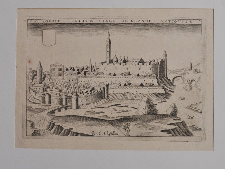
[RHÔNE L’ARBESLE] - CHASTILLON (Claude).
La Besle petite ville de grande antiquité. Estampe originale
[Paris, Boisseau, vers 1640], [Paris, Boisseau, vers 1640]11,5 X 17,5 cm. sur une feuille de 20 x 27 cm., monté dans un passe-partout. Vue de la ville tirée de Topographie françoise parue chez Boisseau.
书商的参考编号 : 46405254
|
|
|
[Robert de Vaugondy] Delamarche (C. F.)
Europe divisée en ses Empires, Royaumes et Républiques, par C.F. Delamarche, géographe, et successeur de Robert de Vaugondy.
français An XII (1803). Carte entoilée dépliante (55x73 cm) de 18 panneaux, aux contours finement aquarellés de l'époque. Etui en plein papier bleu de l'époque orné de dentelle dorée, titre frappé or sur le plat supérieur. Revue et corrigée suivant les nouvelles divisions. Bel exemplaire.
|
|
|
[ROLLIN] - LETRONNE (M.).-
Atlas de géographie ancienne pour servir à l'intelligence des oeuvres de Rollin.
1827 Paris, Firmin-Didot, 1827, petit in folio relié demi-veau vert olive, dos lisse orné de filets dorés, titre en long.
书商的参考编号 : 79455
|
|
|
[ROLLIN] - LETRONNE (M.).-
Atlas de géographie ancienne pour servir à l'intelligence des oeuvres de Rollin.
1827 Paris, Firmin-Didot, 1827, Grand in-4 de 7 pp. + 17 cartes et plans à double-page montés sur onglet ; cartonnage de l'époque, vignette de titre sur le premier plat. relié demi-veau, 17 plans et cartes, frontières réhaussées en couleurs
书商的参考编号 : 13410
|
|
|
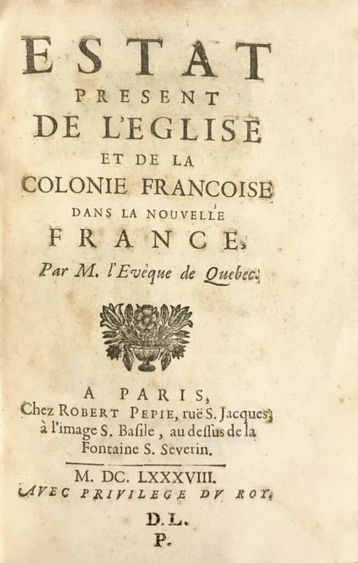
[SAINT-VALLIER (Jean Baptiste de La Croix de Chevrières de)].
Estat present de l’Eglise et de la colonie françoise dans la Nouvelle France, par M. l’Evêque de Québec. Les tribus Indiennes du Canada à la fin du XVIIè siècle.
Exemplaire très pur et à belles marges conservé dans sa première reliure en veau de l’époque. Paris, chez Robert Pepie, 1688. In-8 de (1) f., titre, 267 pp., (1) p. Au bas de la dernière page on lit: “A Paris, de l’Imprimerie de la veuve Denis Langlois, 1688”. Cachet D.L.P. en bas du titre. Relié en veau brun granité de l’époque, dos à nerfs orné, coupes dorées, tranches dorées sur marbrures. Reliure de l’époque. 186 x 118 mm.
书商的参考编号 : LCS-18423
|
|
|
[Spanien, Portugal, Madrid]
?Spanien und Portugal [...] von C. Glaser?. Grenzkolor. lithogr. Karte. (Aus: Glaser, C. Vollständiger Atlas).
(Mainz, um 1840). 39,5 x 48 cm. Mittig gefaltet (wie erschienen).
书商的参考编号 : 40835

|
|
|
[SUISSE] Bureau de Statistique du Département fédéral de l'intérieur:
Atlas graphique et statistique de la Suisse. 1914.
Berne, Bureau de Statistique du Département fédéral de l'intérieur, 1914. In-folio oblong de [2]-6 pages et 64 tableaux imprimés en couleurs. Coupes et coins légèrement frottés, plats un peu sali.
书商的参考编号 : 13240
|
|
|
[SYRIA - MAP].
[MAP OF SYRIA] Harita al-Suriyah. Calligraphed by Kamel Al-Baba, (1905-1991).
Very Good Arabic Original chromo-lithograph map in brown tones. On a special paper with an ongoing blindstamped "Regestre Robur" during the borders. Folded. 70x100 cm. In Arabic. Scale: 1 /1.000.000. Chipped on margins, split on folded traces. Slight discoloration and one stain on lower margin. Otherwise a good copy. An attractive and detailed map of Syria shows the capital (as Aleppo n that map), other cities like Damascus, Raqqa, Homs, Latakia, Ayn al-Arab, Idlib, Hama, Deir Ez-Zor, Jarabulus, et alli. And it shows Turkey on the north (as Turkey containing Hatay and Alexandrette), The Mediterranean shores of the land as well as Lebanon and Palestine (and Jerusalem) on the west, Sharq al-Urdun (Jordan) and Iraq on the south and east. It's very detailed on showing the roads spread throughout the land like railways and ancient roads from the Roman period. Additionally this roads can be followed to the other Arabic countries and regions on the map. This map was calligraphed by Kamel Al-Baba, (1905-1991), who was a Lebanese contemporary / modern calligrapher. He is the son of famous calligrapher Mokhtar Al-Baba. Cannot be found in WorldCat.; Not in Library of Congress Map Collection. Very scarce.
|
|
|
[Topographischer Atlas der SCHWEIZ (Siegfriedatlas) / Atlas topographique de la Suisse / Atlante topografico della Svizzera ]
Topographischer Atlas der SCHWEIZ (Siegfriedatlas). Blatt Nr. 382: ISENTHAL
Bern, Landestopographie, 1919. Carte papier dépliante en couleurs (335x420mm). Echelle 1:50.000. Karte. Map. Infimes défauts, bon état.
书商的参考编号 : 36987
|
|
|
[Topographischer Atlas der SCHWEIZ (Siegfriedatlas) / Atlas topographique de la Suisse / Atlante topografico della Svizzera ]
Topographischer Atlas der SCHWEIZ (Siegfriedatlas). Blatt Nr. 200: MENZBERG.
Bern, Landestopographie, 1919. Carte papier dépliante en couleurs (335x420mm). Echelle 1:25.000. Karte. Map. Infimes défauts, très bon état.
书商的参考编号 : 36988
|
|
|
[Topographischer Atlas der SCHWEIZ (Siegfriedatlas) / Atlas topographique de la Suisse / Atlante topografico della Svizzera ]
Topographischer Atlas der SCHWEIZ (Siegfriedatlas). Blatt Nr. 418 : CHURWALDEN.
Bern, Landestopographie, 1924. Carte papier dépliante en couleurs (335x420mm). Echelle 1:50.000. Karte. Map. Petits défauts, bon état.
书商的参考编号 : 36989
|
|
|
[Topographischer Atlas der SCHWEIZ (Siegfriedatlas) / Atlas topographique de la Suisse / Atlante topografico della Svizzera ]
Topographischer Atlas der SCHWEIZ (Siegfriedatlas). Blatt Nr. 388 : GISWILERSTOCK
Bern, Eidgenössisches Topographisches Bureau, Topographischer Atlas der SCHWEIZ. 1894. Carte papier dépliante en couleurs (440X360mm). Echelle 1:50.000. Carte. Map. TRES BON ETAT.
书商的参考编号 : 37005
|
|
|
[Ungarn]
?A nemet Bánati Hatarörzö Regement Videkenek Tablaya?.
[Wien, um 1810]. Grenzkolor. Kupferstich-Karte von B. Biller aus D. v. Görög, Magyar Atlas (Blattgröße 36,6 x 28,9 cm, Darstellung 27,5 x 22 cm).
书商的参考编号 : 55228

|
|
|
[Ungarn]
?Györ Varmegye (Comitatus Jaurinensis)?.
[Wien, um 1810]. Grenzkolor. Kupferstich-Karte von J. Berken aus D. v. Görög, Magyar Atlas (Blattgröße 27,5 x 35 cm, Darstellung 22,5 x 28,2 cm).
书商的参考编号 : 55226

|
|
|
[Ungarn]
?Pest, Pilis, es Solt törvenyesen egyesült Varmegyek?.
[Wien], 1811. Grenzkolor. Kupferstich-Karte aus D. v. Görög, Magyar Atlas (Blattgröße 37 x 28,5 cm, Darstellung 29,2 x 22,2 cm).
书商的参考编号 : 55229

|
|
|
[Ungarn]
?Szerem Varmegye (Comitatus Sirmiensis)?.
[Wien, um 1810]. Grenzkolor. Kupferstich-Karte aus D. v. Görög, Magyar Atlas (Blattgröße 27,1 x 37,5 cm, Darstellung 22,3 x 28,9 cm).
书商的参考编号 : 55227

|
|
|
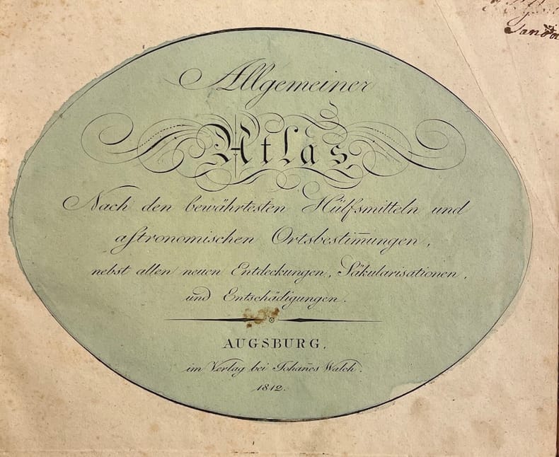
[WALSCH (Johannes)]
Allgemeiner Atlas, Nach den bewährtesten Hülfsmitteln und astronomischen Ortsbestimmungen.
Augsburg, im Verlag bei Johannes Walch, 1812. Pt. in-4° oblong (25,5 x 21 cm), 36ff. Reliure d'époque demi-basane à coins, pièce de titre rouge au dos.
书商的参考编号 : 39755
|
|
|
[Walser, Gabriel; J. J. Mezger]
Schweizerischer Atlas bestehend in 19 Carten.
Ohne Ort, ohne Verlag bzw. Drucker, o. J. (um 1770). Qu.-4° (32,5 x 28 cm). Mit gest. Titel von J. J. Mezger u. 19 grenz- u. flächenkolor. Kupferkarten. Einfacher grüner Kart.-Umschlag d. Zt. m. handschriftl. Deckeltitel.
书商的参考编号 : 64868

|
|
|
[YILDIZ PALACE MAP ON SILK HANDKERCHIEF FOR THE SOCIAL AIDS IN THE PERIOD OF SULTAN ABDULHAMID 2].
[THE GRECO-TURKISH WAR MAP ON A SILK HANDKERCHIEF MADE IN YILDIZ PALACE] Devlet-i Aliyye ve Yunan Muhaberebesi. Engraved map of the Greco-Turkish War in 1897 on a silk handkerchief made in Yildiz Palace in the period of Sultan Abdulhamid II.
Very Good Turkish, Ottoman (1500-1928) Original engraved map on the silk handkerchief made in Yildiz Palace for the 'Iane Sergisi' [i.e. Exhibition of the Social Assistance] in the period of Sultan Abdülhamid II. In its decorative frame. Frame size: 53,5x53,5 cm; map size: 38x38 cm. In Ottoman script. Scale: 1/600.000. Several minimal splits, minor foxing, and slight stains on cloth. Otherwise in good condition. A rare and decorative 1897 silk handkerchief map of the Greco-Turkish War in 1897, which was the only war in which the Ottoman army was victorious during the reign of Abdulhamid 2, is a fine example of Ottoman / Turkish cartographic textiles made in Ottoman court (Yildiz Palace textile workshops). This beautiful map depicts an attractive war scene from the 1313 Greek War on the upper half, and it's engraved a map of Balkan & Greek lands on its lower half. War painting has 'Melona' signature in Ottoman script. The map shows Thessaloniki [i.e. Salonica] Bay on the west; Yanya [i.e. Ioanna] Vilayat on the east; lands of Greece, Galos Bay, Uzi Strait on the south and Dimetoka and Avalonia areas in the Serefiye, Ergiri sanjaks on the north in its period. Written on the map, "Baht-i himâye-yi feyzvâne-i cenâb-i hilâfetpenâhide evlad-i süheda ve mecrûhin-i asakir-i sâhâne", [i.e. It was printed for the "Iane Sergisi" (i.e. The Social Help Exhibition) in the high memory of our soldiers who were martyred and veterans in the Greek War under the patronage of the Sultan.]. The Greco-Turkish War of 1897, also called the Thirty Days' War and known in Greece as the Black '97 (Mauro '97), or the Unfortunate War (Atychis polemos), was a war fought between the Kingdom of Greece and the Ottoman Empire. Its immediate cause was the question over the status of the Ottoman province of Crete, whose Greek majority long-desired union with Greece. Despite the Ottoman victory on the field, an autonomous Cretan State under Ottoman suzerainty was established the following year (as a result of the intervention of the Great Powers after the war), with Prince George of Greece and Denmark as its first High Commissioner. This was the first war effort in which the military and political personnel of Greece were put to test since the Greek War of Independence in 1821. For the Ottoman Empire, this was also the first war effort in which the reorganized military personnel were put to test. The Ottoman army was under the guidance of a German military mission led by Colmar Freiherr von der Goltz, who had reorganized it after the defeat in the Russo-Turkish War (1877-1878). The conflict proved Greece was wholly unprepared for war. Plans, fortifications and weapons were non-existent, the mass of the officer corps was unsuited to its tasks, and training was inadequate. As a result, the numerically superior, better organized, equipped and led Ottoman forces pushed the Greek forces south out of Thessaly. Almost all of the aids made to the families or disabled people of those who were martyred in the 1897 Ottoman-Greek War (such as printing this map) were made within the framework of the donations of "Evlâd-i Süheda and Malûlîn-i Guzât-i Asâkir-i Sahane". People and citizens of all classes and beliefs, including members of the Ottoman court, ministers, bureaucrats, civil servants, merchants and tradesmen, participated in this aid campaign at the end of the 19th, beginning of the 20th century. Not in OCLC.
|
|
|
[Zweisimmen - Gemmi]
Zweisimmen - Gemmi. 1:50.000. Ueberdruck. (= Topographischer Atlas der Schweiz).
Bern, Eidgenössisches topographisches Bureau, 1892. Farb. Karte (56 x 78 cm) mit Titelschild, in 18 Segmenten auf Lwd. aufgezogen.
书商的参考编号 : 50084

|
|
|
[Zürner, Adam Friedrich]
Kurze Geographie von Deutschland oder Atlas Portatilis Germanicus. Nebst einem Verzeichnis aller jetzt regierenden hohen Häupter Deutschlands.
Nürnberg, Christoph Weigel, 1780. 8°. Mit 37 doppelblattgr. kolor. Kupferkarten. 8 Bll., 186 S., 98 Bll., HLdr. d. Zt. a. 5 Bünden m. Rückenverg., goldgepr. Rückenschild u. Rotschnitt.
书商的参考编号 : 65196

|
|
|
[ÜST. A. RIZA, (1874-1935)].
Ottoman map of Eastern Anatolia. Bargiri, Hoy, Baskal'a, Malazgird.
Very Good Turkish, Ottoman (1500-1928) Original color map. 50x60 cm. In Ottoman script. Scale: 1/200000. Ottoman map of Eastern Anatolia. Bargiri, Hoy, Baskal'a, Malazgird. It shows Lake Erçek located on the east of Lake Van which is an endorheic salt lake in Van Province in eastern Turkey, about 30 kilometres; on north side, Bargiri place where the oldest district of Van city; on east, Turkish and Azerbaijani and Iranian borders and Hoy city of the West Azerbaijan; and on west, map shows Malazgird [Malazgirt]. This is one the serie of the Bonn projection maps which are the first map series in modern techniques in Turkey and the Ottoman Empire. In order to produce these maps covering Turkish territory, Reconnaissance Branch was incorporated into The Mapping Commission. The maps were produced in the datum based on the latitude and longitude of Ayasofya Mosque in equal area Bonn Projection. The field works for the 123 sheets covering the country were conducted by 76 staff. The production was completed in 18 years starting from east west. Field works continued without stopping except in years 1914 and 1920. This map series called also reconnaissance maps contributed a lot to producing 1:25.000 scale maps.
|
|
|
A Color Atlas of Hypertension
Maurice B. Buchalter Hardcover 1991
Hardcover. LIKE_NEW. hardcover
书商的参考编号 : 340283902412 ???????? : 0815176635 9780815176633
|
|
|
A Member of the 1955 Oxford University Expedition to the Atlas Mountains
Five Men and a Truck. An original article from the Wide World Magazine 1957
Wide World Magazine August 1957 1957. First Edition. Disbound. Very Good Condition. Octavo. 6 pages with 6 photos and 2 illustrations. Note; this is an original article separated from the volume not a reprint or copy. Quantity Available: 1. Category: Wide World Magazine; Inventory No: 161689. Wide World Magazine, August, 1957 unknown
书商的参考编号 : 161689

|
|
|
A Z Street Atlas
Middlesborough Stockton on Tees including Darlington Hartlepool etc.
Geographers' A-Z Map Company 1991. Scale 4" to 1 mile. Paper covers. V.g. . Little used. 197 pp. Geographers' A-Z Map Company unknown
书商的参考编号 : 6275

|
|
|
 ?????????
 ?????PDF???
 RSS feed


