|
KERMAINGANT, Mathurin François.
Mémoire sur le Projet d’un Chemin de Fer de Lyon à Marseille. Ministère des Travaux Publics de l’Agriculture et du Commerce. Direction Générale des Ponts et Chaussées et des Mines.
Paris, Imprimerie Royale, 1837. In-4 – 22,5 x 29 cm. Broché. 172 pages, 1 carte dépliante en 2 parties. Edition originale. Ouvrage complet de sa grande « Carte Générale des tracés du Chemin de Fer de Lyon à Marseille » très détaillée (150 x 57cm). On découvre le tracé proposé sur la rive droite du Rhône, rehaussé en vert, et celui sur la rive gauche du Rhône, rehaussé en rouge, les deux se rejoignant à Tarascon puis poursuivant par Arles et les Martigues. Un tracé alternatif de la rive gauche, rehaussé en jaune, entre la Durance et Marseille, envisage une bifurcation à partir d’Avignon en passant par Orgon, Salon, Aix, Fuveau, Aubagne et la vallée de l’Huveaune. Mathurin François Kermaingant (1779-1856) est un ingénieur originaire du Nord de la France. Il intègre l'école des Ponts et Chaussées en 1800. Quatre ans plus tard, il est affecté au service de route de la Drôme. Il quitte ce département pour celui du Rhône en 1810, puis y revient en 1821, pour 3 années. C'est dans la Sarthe qu'il poursuit sa carrière à partir de 1824. A la demande du gouvernement, il pilote la commission d'étude sur un futur chemin de fer dans la vallée du Rhône en 1833. Il suggère de nombreuses variantes de tracés. En 1836, il est nommé ingénieur en chef. Il quitte le sud de la France puis s'occupe du chemin de fer de Paris à Versailles.
Bookseller reference : 2321

|
|
|
Kettle, Michael; Maps/ Plates [Illustrator]
The Allies and the Russian Collapse March 1917 - March 1918 Russia and the Allies 1917-1920 Volume One
University Of Minnesota Press 1981-01-01. Paperback. Very Good. Please Read price clipped inside cover - No marks on text - My shelf location 41-e-22 University Of Minnesota Press paperback
Bookseller reference : 211002002 ISBN : 0816609810 9780816609819

|
|
|
KEULEN (Johannes van).
Paskaart van Gallissien van C. de Finisterre tot aen Zurara.
Amsterdam, [circa 1700]. 505 x 567 mm.
Bookseller reference : LBW-950

|
|
|
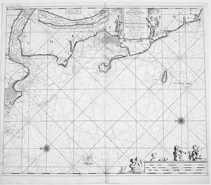
KEULEN (Johannes van);
Nieuwe pascaart van de zeekusten van Bretangne en Poictou.
Amsterdam circa 1700 494 x 583 mm.
Bookseller reference : LBW-811
|
|
|
KEULEN (Johannes van);
Nieuwe pascaart van een gedeelte van Bretangne.
Amsterdam circa 1700 513 x 592 mm.
Bookseller reference : LBW-814

|
|
|
KEULEN (Johannes van);
Pascaart van de zeekusten van Galissen.
Amsterdam circa 1700 511 x 588 mm.
Bookseller reference : LBW-818

|
|
|
Key Maps
Houston Harris County 2013 Key Map 52nd Edition
Used - Very Good. Used book that is in excellent condition. May show signs of wear or have minor defects. unknown
Bookseller reference : 54927133-6 ISBN : 1885822707 9781885822703
|
|
|
Key Maps
Houston Harris County atlas
unknown_binding. Good. Access codes and supplements are not guaranteed with used items. May be an ex-library book. unknown
Bookseller reference : 1885822146.G ISBN : 1885822146 9781885822147
|
|
|
Key Maps
The Multi-Color Houston and Harris County Atlas
Key Maps Inc. 1982. Orange binder has light wear a few smudges. Title page lightly stained. Text has no markings. Binder. Good/No Jacket. 4to - over 9¾" - 12" tall. Key Maps, Inc. Hardcover
Bookseller reference : 004682J
|
|
|
Khaled Al Ankary
La Péninsule arabique dans les cartes européennes anciennes, fin XVème- début XIXème siècle. Collection Khaled Al Ankary. Exposition du 15 Septembre au 28 Octobre 2001/ The arabian peninsula In old european maps. From the end of 15th century to the beginning of 19th century. Khaled Al Ankary collection. Exhibition from September 15th to October 28th 2001.
Institut du monde arabe, Paris 2001. Hardcover Sehr gut
Bookseller reference : 032557

|
|
|
KIEPERT (Heinrich).
[EMPIRE OTTOMAN] Karte des Türkischen Reichs in Asien.
Berlin, S. Schropp u. Comp, 1853. En 21 sections montées sur toile et repliées, formant une carte de 633 x 920 mm ; sous chemise et étui de papier marbré vert de l'époque, avec titre en lettres dorées sur pièce de titre rouge ; étiquette au dos de l'éditeur parisien J. Andriveau-Goujon.
Bookseller reference : LBW-8624

|
|
|
Kiepert, H(einrich)
Karte des russischen Reichs in Europa. Maßstab 1 : 3.000.000.
Berlin, Dietrich Reimer, 1893. Farblithografie, zwei Teile je 122,5 x 67,5 cm (Blattgr. 137,5 x 71 cm) in zus. 88 Segmenten auf Leinen aufgezogen. Zusammen in Leinenschuber d. Zt. mit Titelschild der Londoner Landkartenhandlung Edward Stanford, r1 6. verb. Auflage. (dieser mit geringen Gebrauchsspuren).
Bookseller reference : 49033AB

|
|
|
Kiepert, Richard
4 Karten aus Richard Kiepert's Deutschen Kolonial-Atlas für den amtlichen Gebrauch in den Schutzgebieten.
Berlin, Dietrich Reimer, (1893). Ca. 75 x 57 cm. 4 Farblithografien, gefaltet. Zusammen lose in HLn.-Band der Zeit mit aufkaschiertem Deckeltitel, ko (etwas angeschmutzt und fleckig).
Bookseller reference : 49113AB

|
|
|
Kiesel, O.E. [Otto Erich] (Bearb.)
Hamburg. Führer durch die Freie und Hansestadt und ihre Umgebung. Offizieller Führer des Fremdenverkehrs-Vereins Hamburg. 3., stark erweiterte Ausgabe.
Hamburg, Broschek & Co. 1924. 184 S. incl. 24 S. Anzeigenanhang. Mit Vignetten u. zahlr., tls. ganzseit. Abb. in Kupfertiefdruck 2 eingeschalt. Verkehrslinien-Plänen, 1 Tafel mit Ohlsdorf-Plan sowie 1 mehrfach gefalteten farbigen Pharus-Straßenplan im Anhang (Maßstab 1 : 14700; 40 x 50,5 cm). Farb. illustr. OBrosch.
Bookseller reference : 88292

|
|
|
KILIAN (Georg Christophe);
[NORVEGE] Schloss Bahus in Norwegen.
Augsbourg circa 1740 163 x 177 mm.
Bookseller reference : LBW061eb

|
|
|
KILIAN Conrad:
Au Hoggar. Mission de 1922.
Paris, Société d'éditions géographiques, maritimes et coloniales, 1925. In-8 broché de [2]-190 pages, couverture verte imprimée en noir, ornée d'une vignette qu'on retrouve au dos (passé). Bords du premier plat insolés, déchirure sans perte au second plat. Intérieur frais, en majeure partie non coupé.
Bookseller reference : 10484

|
|
|
Kilmann Ralph H
Social Systems Design: Normative Theory and the Maps Design Technology
Elsevier Science Ltd 1977 344 pages in8. 1977. Cartonné jaquette. 344 pages.
Bookseller reference : 100125543 ISBN : 444001980

|
|
|
Kimble, George HT.; Illustrated by Maps, photos [Illustrator] H. T.
Tropical Africa: Volume I Land and Livelihood and Volume II Society and Polity
20th Century Fund 1960-01-01. Hardcover. Very Good/Unclipped . 0x0x0. Both volumes in this set are immaculate and unmarked except for former owner's name on front end pages; many interesting period photos in both vols.; bindings firm; boards fine well-protected by very good d.j.s having minimal wear. Collectible first edition. 20th Century Fund hardcover
Bookseller reference : 042296
|
|
|
Kindersley Barnabas Kindersley Anabel
Des enfants comme moi
GALLIMARD JEUNE 80 pages 24 4x1 2x30 4cm. Sans date. Broché. 80 pages.
Bookseller reference : 500186562

|
|
|
King, Dean with John B. Hattendorf, editors; maps by Adam Merton Cooper
Every Man Will Do His Duty: An Anthology of Firsthand Accounts from the Age of Nelson
New York: Henry Holt & Company 1997. 1st. Hardcover. Book fine Dust jacket fine. <br/><br/> Henry Holt & Company hardcover
Bookseller reference : 9010406 ISBN : 0805046089 9780805046083

|
|
|
King, John ; Nebesky, Richard and Wilson, Neil
Lonely Planet : Prague
No inscriptions or marks. No creasing to covers or to spine. A lovely clean crisp very tight copy with bright unmarked boards and no bumping to corners. Appears unused. 240pp. Fourth edition.

|
|
|
KINGSLEY David
Printed Maps of Sussex 1575-1900. With Introduction by Helen Wallis. NEAR FINE COPY IN UNCLIPPED DUSTWRAPPER
4to., First Edition, with frontispiece and 40 plates of facsimiles; original series binding of brown cloth, gilt back, a near fine copy in unclipped dustwrapper. SRS Vol. 72. With the separately printed corrigenda slip.
|
|
|
Kingsolver, Barbara, Cartes, Rebecca, Seal Press Staff
Another America : Otra America
Basic Books. Used - Very Good. Used book that is in excellent condition. May show signs of wear or have minor defects. Basic Books unknown
Bookseller reference : 4294988-6 ISBN : 1580050042 9781580050043

|
|
|
Kingsolver, Barbara; Cartes, Rebeca (translator)
Another America: Otra America
Avalon Publishing Group 1992. Paperback. Good. Missing dust jacket; Pages can have notes/highlighting. Spine may show signs of wear. ~ ThriftBooks: Read More Spend Less.Dust jacket quality is not guaranteed. Avalon Publishing Group paperback
Bookseller reference : G187806715XI3N01 ISBN : 187806715X 9781878067159

|
|
|
Kingsolver Barbara; Cartes Rebeca Translator
Another America/Otra America English and Spanish Edition
Seal Press 1994-08-01. Paperback. New. In shrink wrap. Looks like an interesting title! Seal Press paperback
Bookseller reference : Q-1878067575 ISBN : 1878067575 9781878067579

|
|
|
Kingsolver, Barbara; Cartes, Rebecca
Another America/Otra America English and Spanish Edition
Seal Press 1992. 1st Edition 1st Printing. Hardcover. Fine/Fine. FINE IN FINE DUST JACKET. <br/> <br/> Seal Press hardcover
Bookseller reference : AG63 ISBN : 1878067141 9781878067142

|
|
|
Kingsolver, Barbara; Cartes, Rebeca
Another America/Otra America English Spanish and Spanish Edition
Seal Pr 1992-03-01. Hardcover. New. In shrink wrap. Looks like an interesting title! Seal Pr hardcover
Bookseller reference : Q-1878067141 ISBN : 1878067141 9781878067142
|
|
|
Kingsolver, Barbara (transby Rebeca Cartes) s. by
Another America/Otra America
Seattle WA: Seal Press 1992. Advance Uncorrected Galley Proofs . Paper Back. Very Good/No Jacket. 4to - over 9¾" - 12" tall. 103pp.; SC blk.plastic comb-binding w/clear plastic cover; slight rub w/cleantight pgs. "Poems by Barbara Kingsolver. Spanish translations by Rebeca Cartes. <br/> <br/> Seal Press unknown
Bookseller reference : 050926 ISBN : 187806715X 9781878067159

|
|
|
Kingsolver, Barbara, Cartes, Rebecca, Seal Press Staff
Another America : Otra America
Basic Books. Used - Very Good. Used book that is in excellent condition. May show signs of wear or have minor defects. Basic Books unknown
Bookseller reference : 4294988-6 ISBN : 1580050042 9781580050043
|
|
|
Kingsolver, Barbara, Cartes, Rebecca, Seal Press Staff
Another America : Otra America
Basic Books. Used - Good. Used book that is in clean average condition without any missing pages. Basic Books unknown
Bookseller reference : 4865512-75 ISBN : 1580050042 9781580050043
|
|
|
Kingsolver, Barbara with Spanish translations by Rebeca Cartes
Another America: Otra America
Seattle: Seal Press 1992. 3rd printing. Fine paperback book in decorative wrappers soft cover book. 103 pages. Seattle: Seal Press paperback
Bookseller reference : 2020371 ISBN : 187806715x 9781878067159
|
|
|
Kingsolver, Barbara; Cartes (translator), Rebeca
Another America Otra America with Spanish Translations
Seal Press 1992. Very Good. Kingsolver Barbara. Another America Otra America with Spanish Translations. Cartes translator Rebeca. Seattle: Seal Press 1992. 103pp. 12mo. Paperback. Book condition: Very good with lightly rubbed and bumped edges. Seal Press paperback
Bookseller reference : UKINANO00CCW
|
|
|
Kingsolver, Barbara; Cartes, Rebeca (translator)
Another America
Book. Fine. Hardcover. 1st Edition. A LIKE NEWFIRST EDITION IN DJ. Hardcover
Bookseller reference : F02497 ISBN : 1878067141 9781878067142
|
|
|
Kingsolver, Barbara; Cartes, Rebeca
Otra America / Another America
Seal Pr Feminist Pub . Used - Very Good. May have light to moderate shelf wear and/or a remainder mark. Complete. Clean pages. Seal Pr Feminist Pub unknown
Bookseller reference : 1408337 ISBN : 1580050042 9781580050043
|
|
|
Kingsolver Barbara; Cartes translator Rebecca
Another America: Otra America Bilingual English / Spanish
Seal Press 1992. Fine. Kingsolver Barbara. Another America: Otra America Bilingual English / Spanish. Cartes translator Rebecca. Seattle: Seal Press 1992. 104pp. 8vo. Black cloth with gilt lettering. Signed by author. Inscribed by author. Book condition: Near fine. Inscribed by author on title page. Dust Jacket Condition: Near fine. Very slight weat along bottom edge. In protective cover. Seal Press hardcover books
Bookseller reference : RKINANO00JKN
|
|
|
Kingsolver Barbara; Cartes translator Rebeca
Another America Otra America with Spanish Translations
Seal Press 1992. Very Good. Kingsolver Barbara. Another America Otra America with Spanish Translations. Cartes translator Rebeca. Seattle: Seal Press 1992. 103pp. 12mo. Paperback. Book condition: Very good with lightly rubbed and bumped edges. Seal Press paperback books
Bookseller reference : UKINANO00CCW
|
|
|
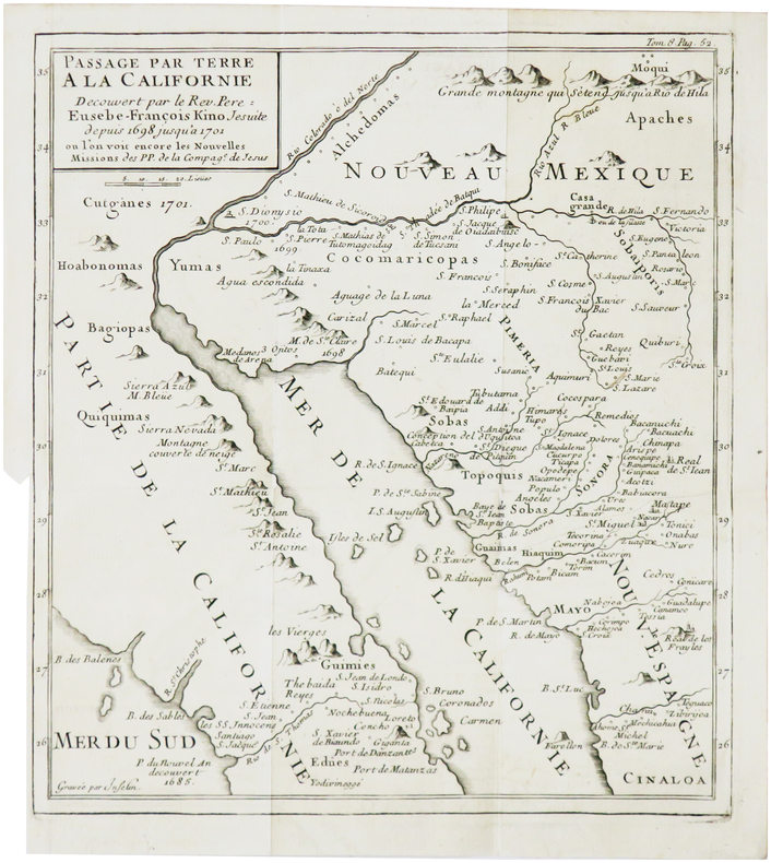
KINO (Eusebio Francisco).
[CALIFORNIE] Passage par terre à la Californie découvert par le Rév. Père Eusebe-François Kino jésuite depuis 1698 jusqu'à 1701, où l'on voit encore les nouvelles missions des PP. de la Compag.e de Jésus.
[1781]. 236 x 211 mm.
Bookseller reference : LBW-7867
|
|
|
Kinsei Seinen Publishing Co., Ltd. Editorial Department of Literary Maps
student literary dictionary
Not Available 1982. Soft Cover. Fine. Number of books: 1 Not Available paperback
Bookseller reference : 2091502135401251
|
|
|
KIRCHER Athanasius (1601 circa - 1680)
Tabula Geographico-Hydrographica Motus Oceani, Currentes, Abyssos, Montes Igniuomos In Universo Orbe Indicans
Straordinaria mappa fisica ed idrografica del mondo, raffigurante le correnti oceaniche, profondità marine ed i vulcani. La carta è tratta dal Mundus Subterraneus del Kircher, studioso gesuita, uno dei primi scrittori sui fenomeni fisici della terra. Il Kircher teorizzava che tutti gli oceani della Terra erano connessi tra loro tramite dei tunnel sotterranei che univano oceani e mari. Tra il Mar Mediterraneo, il Mar Nero, il Mar Caspio e il Golfo Persico, Kircher ha teorizzato enormi gallerie e un complesso interscambio di flussi d'acqua. Questi tunnel sono particolarmente noti tra il Mar Nero e il Mar Caspio e tra il Mediterraneo e il Golfo Persico. L'Antartide è rappresentata lungo la parte meridionale della mappa. A nord è raffigurato un grande passaggio aperto a nord-ovest che corre lungo tutta la mappa. Mostra la Nuova Guinea e una suggestione dell'Australia collegata alla terraferma Australsis Incognita. L'Africa è mostrata con una precisione notevolmente maggiore rispetto a molte mappe disegnate centinaia di anni dopo - in particolare per quanto riguarda il Niger e i sistemi fluviali del Nilo. Il Nord America e il Sud America sono entrambi maldestramente raffigurati, il che indica una conoscenza relativamente sommaria del continente. La Corea viene mostrata come un'isola e il Giappone appare come un'unica isola. Incisione in rame, in eccellente stato di conservazione. Extraordinary map, both form the physical and hydrographic point of view, depicting ocean currents, volcanoes and deep-sea chasms. The map is taken from Kircher’s Mundus Subterraneus . The Jesuit scholar, Athanasius Kircher, was one of the first compilers of semi-scientific knowledge about the physical features of the world. This map expounds on Kircher's theories by noting the abysses and the currents they create as well as the locations of the world's known volcanoes. Between the Mediterranean Sea, the Black Sea, the Caspian Sea, and the Persian Gulf, Kircher theorized massive tunnels and a complex interchange of water flows. These tunnels are noted most particularly between the Black and Caspian Sea and between the Mediterranean and the Persian Gulf. Antarctica is shown along the southern part of the map. In the North a great open northwest passage is depicted running all the way across the map. Shows New Guinea and a suggestion of Australia attached to the 'Australsis Incognita' mainland. Africa is shown with considerably greater accuracy than many maps drawn hundreds of years later – particularly with regard to Niger and Nile River Systems. North America and South America are both wildly malformed, indicating a relatively sketchy knowledge of the continent. Korea is shown as an Island and Japan appears as only a single island.Published in a Dutch edition of Kircher's famous Subterranean World by Johann Waesberger.Copperplate, in excellent condition. Shirley, The Mapping of the World, 459.

|
|
|
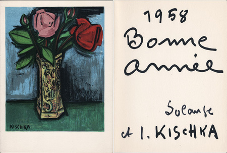
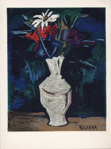
Kischka, Isis
Isis Kischka : carte de voeux pour 1958 et lithographie originale
1958 Carte de voeux de lsis et Solange Kischka pour l'année 1958. 20 x 15 cm, 2 ff., avec au premier plat une lithographie originale signée dans la planche et en page 3 un envoi sérigraphié.
Bookseller reference : 1064
|
|
|
Kischka, Isis
Isis Kischka : carte de voeux pour 1959 et lithographie originale
1959 Carte de voeux de lsis et Solange Kischka pour l'année 1959. 20 x 15 cm, 2 ff., avec au premier plat une lithographie originale signée dans la planche et en page 3 un envoi sérigraphié.
Bookseller reference : 1472
|
|
|
Kiwi Maps
Auckland Complete Metromap 260
NEW. unknown
Bookseller reference : BIB-NOV-15-2025-114020 ISBN : 9415871000228 9415871000
|
|
|
Kiwi Maps
New Zealand Compact Travellers Atlas and Guide
Used - Very Good. Used book that is in excellent condition. May show signs of wear or have minor defects. unknown
Bookseller reference : 12944401-75 ISBN : 9415871001158 9415871001
|
|
|
Kiwi Maps
New Zealand Travellers Road Atlas: 4th edition
C.A. Boot. Used - Good. Good condition. 4th edition. new zealand maps A copy that has been read but remains intact. May contain markings such as bookplates stamps limited notes and highlighting or a few light stains. C.A. Boot unknown
Bookseller reference : D15OS-00379
|
|
|
Kiwi Maps
New Zealand Travellers Road Atlas
Kiwi Maps 01-10-2021. 18. map. Used: Good. 8.00x1.00x10.25. Buy with confidence. Excellent Customer Service & Return policy. Kiwi Maps unknown
Bookseller reference : SONGB00008OOZ6
|
|
|
Kiwi Maps
New Zealand Travellers Road Atlas
Kiwi Maps 01-10-2021. 18. map. New. 8.00x1.00x10.25. Buy with confidence. Excellent Customer Service & Return policy. Kiwi Maps unknown
Bookseller reference : DADAXB00008OOZ6
|
|
|
Kiwi Maps
New Zealand Travellers Road Atlas
Used - Very Good. Very Good Condition! Cover may have light wear pages in very good condition and binding is sturdy; may have other light shelf wear or creases. May have minimal notes or highlighting. Very Good Condition! Cover may have light wear pages in very good condition and binding is sturdy; may have other light shelf wear or creases. May have minimal notes or highlighting. unknown
Bookseller reference : B00008OOZ6-VG
|
|
|
Kiwi Maps
New Zealand Compact Travellers Atlas and Guide 11th edition.
kiwi Maps. Used - Very Good. Very Good condition. 11th edition. Map Atlas guidebook A copy that may have a few cosmetic defects. May also contain light spine creasing or a few markings such as an owner’s name short gifter’s inscription or light stamp. Bundled media such as CDs DVDs floppy disks or access codes may not be included. kiwi Maps unknown
Bookseller reference : N09P-00680
|
|
|
Kiwi Maps
North Island Complete Drivers Atlas With Indexed Country Roads
Kiwi Maps 2014 Spiral bound book. The cover has a little wear. Books listed here are not stored at the shop. Please contact us if you want to pick up a book from Newtown. Paperback. Very Good. Kiwi Maps paperback
Bookseller reference : 179440 ISBN : 5871002668 9785871002667
|
|
|
Kiwi Maps
South Island Complete Drivers Atlas With Indexed Country Roads
Used - Good. Used book that is in clean average condition without any missing pages. unknown
Bookseller reference : 15067104-20 ISBN : 9415871002678 9415871002
|
|
 Receive by email
 Download as PDF document
 RSS feed


