|
Kizer, Benjamin H.
The U.S.-Canadian Northwest: A Demonstration Area for International Postwar Planning and Development
71 pages including index. A guide-book to the future of a vast region awaiting development after the war. A study of the past, present and future of international co-operation in this region. Presents a high challenge to the people of Canada and the US, and their governments. Author was regional chairman of the National Resources Planning Board. Light soiling. Unmarked. Some yellowing. Includes three fold-out maps. Moderate wear to illustrated boards. Nice copy. Book
|
|
|
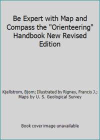
Kjellstrom, Bjorn; Illustrated by Rigney, Francis J.; Maps by U. S. Geological Survey
Be Expert with Map and Compass the Orienteering Handbook New Revised Edition
Charles Scribner's Sons 1967. Paperback. Good. Pages can have notes/highlighting. Spine may show signs of wear. ~ ThriftBooks: Read More Spend Less.Dust jacket quality is not guaranteed. Charles Scribner's Sons paperback
Bookseller reference : GB001ENYZNAI3N00
|
|
|
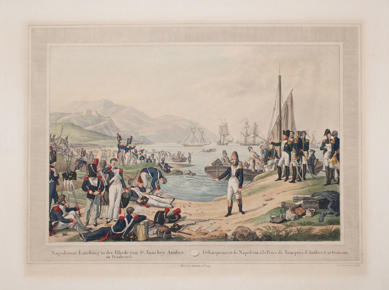
KLEIN (Johann Adam).
[NAPOLEON] Napoleons Landung in der Rhede von St Juan bey Antibes in Frankreich - Débarquement de Napoléon à la baye de Juan près d'Antibes le 28 février 1815.
Vienne, Artaria et Comp., [circa 1815]. 335 x 458 mm.
Bookseller reference : LBW-3289
|
|
|
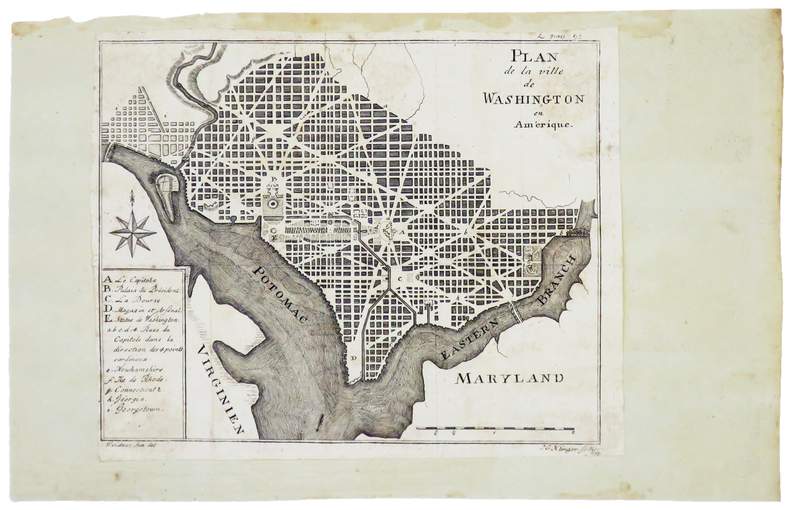
KLINGER (Johann Georg).
[WASHINGTON] Plan de la ville de Washington en Amérique.
[Gotha], 1794. 158 x 197 mm.
Bookseller reference : LBW-4981
|
|
|
Klinger, D. M
Die Frühzeit der erotischen Fotografie und Postkarten.
Nürnberg, DMK, 1984. 4°. 111 S. mit 603 Abb. Orig.-KLeder mit goldgepr. Front- u. RTitel. (= Erotische Kunst Bd. 5.) 1
Bookseller reference : 682A

|
|
|
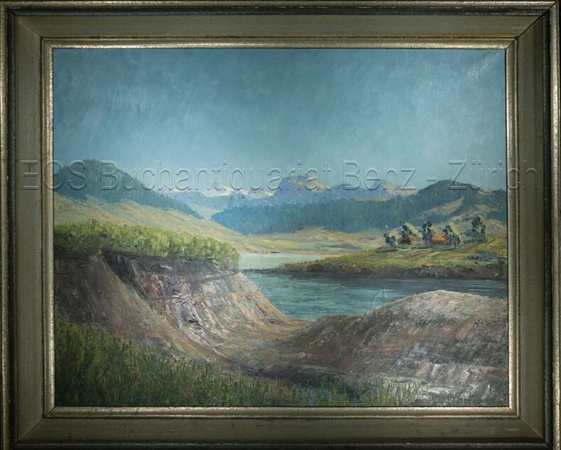
Klopfer, W
Frühling am Sihlsee.
o.J. Oel auf Leinwand. Bildausschnitt: 43 x 54 cm. + Wichtig: Für unsere Kunden in der EU erfolgt der Versand alle 14 Tage verzollt ab Deutschland / Postbank-Konto in Deutschland vorhanden +, Abb.
Bookseller reference : 661DG

|
|
|
Klopfer, W.:
Frühling am Sihlsee.
Oel auf Leinwand. Bildausschnitt: 43 x 54 cm.
Bookseller reference : 661DG
|
|
|
Klose, Olaf / Lilli Martius
Ortsansichten und Stadtpläne der Herzogtümer Schleswig, Holstein und Lauenburg. 2 Bde. (Textband und Tafelband. = komplett).
Neumünster, Karl Wachholtz, 1962. 320 S. (Textband) u. 419 S. (Bildband). Mit 18 Taf. (davon 2 farb.) u. 2 gefalt. Karten im Textband sowie sehr zahlr. Abb. a. Taf. im Bildband. (= Studien zur schleswig-holsteinischen Kunstgeschichte, Bde. 7 u. 8). 4to. OLn. in OPp.-Schuber.
Bookseller reference : 14813
|
|
|
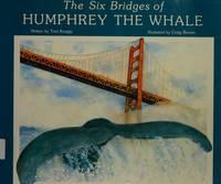
Knapp, T.; color Drawings, Maps [Illustrator]
The Six Bridges of Humphrey the Whale
Roberts Rinehart Inc 1989-01-01. Paperback. Near Fine. P.O. name upper neatly written upper corner reverse of title page else clean tight and unmarked text. Trust an experienced independent bookseller since 1988. Orders are shipped daily via USPS with delivery confirmation. Roberts Rinehart Inc paperback
Bookseller reference : 108981 ISBN : 1879373645 9781879373648
|
|
|
KOELTZ Commandant
D’Esternay aux Marais de Sant-Gond (6-9 septembre 1914)
in 8 broché,faux-titre,titre,219 pages complet des 2 cartes dépliantes,des 20 croquis perspectifs,des 9 photos l’ensemble dans unepochette cartonnée séparée.Charles Lavauzelle & Cie éditeur 1930.légères rousseurs sur la couverture.Très Rare complet
Bookseller reference : 2450
|
|
|
koffie beker bibliotheek
Drinkbeker met bibliotheek motief, mok voor koffie of thee. Becher Bitte nicht storen
, erik tonen books, 2015 Hohe: 10,3 cm - Durchmesser: 8 cm - Inhalt: 300 ml Material: Bone China Porzellan. ISBN 4335915013873.
Bookseller reference : 48014
|
|
|
koffie beker bibliotheek
Drinkbeker met bibliotheek motief, mok voor koffie of thee. Becher Bitte nicht storen
Hohe: 10,3 cm - Durchmesser: 8 cm - Inhalt: 300 ml Material: Bone China Porzellan. ISBN 4335915013873. Begin je dag met een warme drank in je eigen biblio mok !

|
|
|
Koichi Yamazaki / Written and edited Science and engineering maps
Revised Edition Building Certification Application Guidebook
Not Available 1984. Soft Cover. Fine. The book is in fine condition. Not Available paperback
Bookseller reference : 2090502113705843
|
|
|
Kokh, Heidemarie and Photos and Maps
Persepolis and Its Surroundings: A Guide in English
Jan 01 2006. Hardcover. New. hardcover
Bookseller reference : 3N-T1H1-NXNY ISBN : 9643062937 9789643062934
|
|
|
Kokoschka Oskar:
5 cartes postales.
Fondation Kokoschka. 5 cartes postales, détachables.
Bookseller reference : 22842

|
|
|
KOLBE (Pierre).
Description du Cap de Bonne-Espérance ; Ou l'on trouve tout ce qui concerne l'Histoire-Naturelle du Pays ; La Religion, les Moeurs & les Usages des Hottentots ; et l'Establissement des Hollandois. Tirées des Memoires de monsieur Pierre Kolet
Amsterdam,chez Jean Catuffe, 1742 , 3 vol. in-12(170x100mm), 2ffnch , xiii-5ffnch(table) 428pp -1ffnch ,8ffnch – 262pp, 10ffnch-320pp , relié plein veau époque, dos à nerfs ornés avec pièce de titre et tomaison,tranches rouges , défauts d’usages .Seconde édition de la traduction française illustrée de 29 cartes et planches hors-texte
Bookseller reference : PHO-693
|
|
|
KOLBE (Pierre).
Description du Cap de Bonne-Espérance ; Ou l'on trouve tout ce qui concerne l'Histoire Naturelle du Pays ; La Religion, les Mœurs & les Usages des Hottentots ; et l'Establissement des Hollandois. Tirées des Mémoires de monsieur Pierre Kolbe
Amsterdam, chez Jean Catuffe, 1741-43, 3 vol. in-12(170x100mm), 2ffnch., xiii-5ffnch(table) 428pp -1ffnch ,8ffnch – 262pp, 10ffnch-320pp., relié plein veau époque, dos à nerfs ornés avec pièce de titre et tomaison, tome 1 reliure différente. Coins usés, coiffes arasées avec petit manque au dos tome 2, mouillure claire en marge (T1), en coin (T2), page de titre presque détachée (T2), ex-libris manuscrit au tome 1 « Duplat de Monticourt »
Bookseller reference : PHO-2241

|
|
|
Koncnik, Damjan; Kato, Kevin
Greenland - The End of the World (Includes 2 DVDs)
No marks or inscriptions. No creasing to covers or to spine. A very clean very tight copy with bright unmarked boards and no bumping to corners. 222pp. History, culture, nature, travel in Greenland. Two DVDs tucked in with trip details and travel relevant to Greenland.
|
|
|
Konstam, Angus
Historical Atlas of the Napoleonic Era
No marks or inscriptions. A lovely clean very tight copy with bright unmarked boards and no bumping to corners. Dust jacket not price clipped or marked or torn or creased. 192pp. A detailed study of Napoleon Bonaparte's military activities, very well illustrated in particular with maps showing battle plans, conquests, losses and areas covered in the Europe of the early 19th century.

|
|
|
Koshi Mizunoru/Ed. Meiji Maps
New Course of Study Detailed Draft Series Japanese Writing Guidance Detailed Draft 3 Elementary School 56th Grade
Not Available N.A. Soft Cover. Fine. The book is in fine condition. Not Available paperback
Bookseller reference : 2090502113702155
|
|
|
Kossak, Egbert / Markovic, Mirjana
Hamburg | Stadt im Fluß. Hrsg. von der Freien und Hansestadt Hamburg, Baubehörde. (4. Aufl.).
(Hamburg), Ellert & Richter, (© 1989). 352 S. Mit zahlr., meist farb. Abb. 4to. 28,5 cm. OPp. m. SU.
Bookseller reference : 89478

|
|
|
Koury, Michael (Includes John C. Ewers: Making and Uses of Maps by Plains Indian Warriors; Mike Koury: Military Art; Chuck Morga
By Valor & Arms; The Journal of American Military History Vol. 3 # 1 Includes John C. Ewers--Making and Uses of Maps by Plains Indian Warriors; Mike Koury--Military Art; Chuck Morgan--Parachute" - Military Life Preserver of the Air; Robert A. Murray--Water Walking War Wagons; Byron Price--Utopian Experiment: The U.S. Army and the Indian: 1890-1897; Charles R. Smith--And Take What We Pleased".
Fort Collins: Valor & Arms Press 1977. Staplebound Very good. 64pp. Photographs black and white and color illustrations maps. Includes John C. Ewers The Making and Uses of Maps by Plains Indian Warriors Mike Koury Military Art Chuck Morgan " Parachute" - Military Life Preserver of the Air Robert A. Murray Water Walking War Wagons Byron Price The Utopian Experiment: The U.S. Army and the Indian: 1890-1897 & Charles R. Smith " And Take What We Pleased". Locale: United States. Military. Valor & Arms Press Paperback
Bookseller reference : 121299
|
|
|
Kovalevsky (sous la direction de M. W. de) :
La Russie à la fin du 19e siècle. Commission Impériale de Russie à l'Exposition Universelle de Paris.
Paris, Paul Dupont ; Guillaumin, 1900 ; fort in-8, broché ; 989 pp., [1]f. d'Errata, 22 planches hors-texte lithographiées en couleurs (cartes, tableau et graphiques, dont une grande carte dépliante de Russie).
Bookseller reference : 20199

|
|
|
KOYAMA, KICHIZŌ] 小山吉三.
蘭領東印度諸島詳圖 附泰國・佛印・マレー半島. Ranryo Higashi Indo shoto shozu : Fu Taikoku Futsuin Mare hanto. Malay Archipelago.
Tokyo.: 日本名所圖繪社.Nihon Meisho Zuesha. 昭和 17 1942. Folding Japanese coloured map of the Malay Archipelago and Thailand during World War II scale 1:8500000. Legend in lower corner indicates altitudes. Ink annotation in Japanese left edge. Pin holes at three corners upper right corner torn with loss evenly browned otherwise very good. Text in Japanese and English. 52.8 x 75.6cm. This map shows most of Thailand former Indochina Hainan Province and South China Sea Sumatra and Java Sea Borneo the Philippine Islands Celebes Timor New Guinea and parts of Micronesia. Natural resources such as tobacco spices wood sugar metal mines tin iron and etc. rice and other resources are indicated on the map. . 日本名所圖繪社.[Nihon Meisho Zuesha]. unknown
Bookseller reference : 160533
|
|
|
KRACKENBERGER (Helmut).
Photo en couleurs.Aubenas/Ardèche. Le marché des producteurs ardéchois, sur la place du Château.
Aubenas, Krackenberger, s.d. (années 70), 1 photo en couleurs de 11 x 16 cm ;
Bookseller reference : 18666
|
|
|
KRAMER Augustin:
Die Samoa-Inseln. Entwurf einer Monographie mit besonderer Berücksichtigung Deutsch-Samoa von Dr. Augustin Grämer Kaiserlicher Marinestabsartz. Herausgegeben mit Unterstützung des Kolonialabteilung des Auswärtigen Amts. I. Band: Verfassung, Stammäume und Überlieferungen. II. Band: Ethnographie. Anhang zu Band II: Die Wichtigsten Hautkrankheiten der Südsee.
Stuttgart, E. Schweizerbartsche Verlagsbuchhandlung, 1902-1903. 2 volumes in-4 de XII-509p. + X, 445-[6]-26 pages. Pleine toile écrue de l’éditeur.
Bookseller reference : 4544
|
|
|
KREISEL, W. (Willi):
Historische Kupferstichkarten in Schraffenmanier. SA a.d. Schweizer Betr. zur Buchkunde.
Neuchatel, Imprimerie Paul Attinger,, 1939, gr. in-8vo, 16 S. Text + 9 Tafeln mit 18 Abbildungen + (Beigelgt: hs. Dankes-Karte v. Autor), illustrierte Original-Broschüre + Schuber.
Bookseller reference : 130489aaf
|
|
|
KRIVINE Bernard
Thèmes astrologiques. 250 cartes du ciel.
Editions Traditionnelles.1988.In-8,couv.souple bleue.TBE
Bookseller reference : 44204
|
|
|
KROKI 3].
[OTTOMAN MAP OF EASTERN ASIA] Asya-yi Sarkî haritasi.
Very Good Turkish, Ottoman (1500-1928) Original lithograph map partly colored in brown tones. 82x56 cm. (Map print size: 50x46 cm). This map including four different map blocks on the paper. Three small ones include completely Asia, Baycal Lake, and North Russia. The big one includes a very detailed view of Japan, the Sea of Japan, Korea Strait, Korean Peninsula, Korean Bay, Yellow Sea, Shangai, Mongolia, Manchuria, and East Russian lands. No info about the cartographer. "The Cartographer Plotting School was opened to train the cartographers, especially when they were needed on military issues in the Ottoman State. Since there are differences between land maps and sea maps (in terms of measurements), the institution of surveyors emerged. When surveyors were needed also in the Navy, students at the Naval School were trained on this issue, and the gap for surveyors was covered in this way." (SCHOOL OF MAP DRAWING IN THE OTTOMAN STATE, Derya Geçili). Minor splits on foldings. Map in good condition generally.
|
|
|
Kuchar, Karel
Cartes de Boheme (1518-1720). (= Travaux géographiques Tchèques, Bd. 18).
Prag, Vytiskla Ceskoslovenska graficka unie, 1938. 4°. 28 S., OKart.
Bookseller reference : 48731
|
|
|
Kuniyoshi Takekawa Keiko Nagae Masaaki Ito / Written by Meiji Maps
Lesson Plan for “Welfare Volunteer Education†Pioneering Comprehensive Learning 3
Not Available 1999. Soft Cover. Fine. The book is in fine condition. Not Available paperback
Bookseller reference : 2090502113716190
|
|
|
KUNTZ (Milo) & FISCHER (Willy).
[ALSACE] Une belle province de France. L'Alsace.
Strasbourg, Edition F.-X. Le Roux & Cie, 1948. 995 x 610 mm.
Bookseller reference : LBW-7056

|
|
|
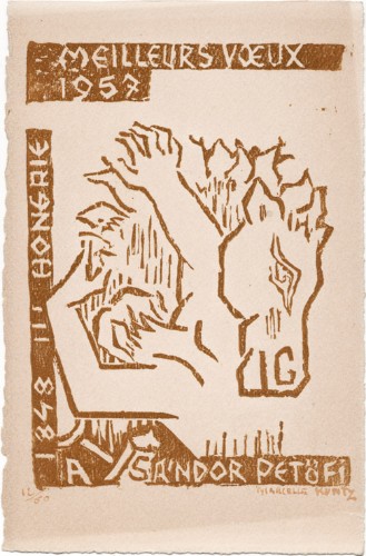
Kuntz, Marcelle
Marcelle Kuntz : carte de voeux pour 1957 et gravure sur bois originale
1957 Carte de voeux de Marcelle Kuntz pour l'année 1957. 19 x 12,5 cm, portant une gravure sur bois inspirée par le poète hongrois Sándor Petöfi, signée et numérotée 12/69 à l'encre rouge.
Bookseller reference : 1481
|
|
|
Kupcik, Ivan
Alte Landkarten. Von der Antike bis zum Ende des 19. Jahrhunderts
Hanau Dausien, 1980. 239 S. mit vielen tlw. farb. Abb. 8° Oln Ou
Bookseller reference : 135
|
|
|
Kutter, W.R.:
Carte des Cantons Bern nch den eidg. Aufnahmen bearbeitet und hrsg. durch W.R. Kutter, Ing. Maßstab 1 : 200.000.
In 24 Segmenten auf Leinen aufgezogen. Aufgefaltet 81 x 70 cm. Farbige Stahlstichkarte, gestochen von Leuzinger. Landkarten de
|
|
|
KYROU (Ado).-
L'âge d'or de la carte postale.
1966 Paris, Balland, 1966, in 4° carré relié pleine toile citron de l'éditeur, jaquette illustrée en couleurs, 151 pages ; très importante iconographie en noir et en couleurs.
Bookseller reference : 79597
|
|
|
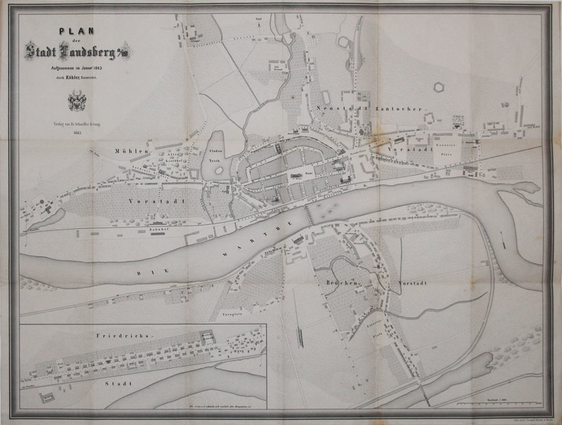
KÖHLER (Christian Wilhelm).
[GORZOW WIELKOPOLSKI] Plan der Stadt Landsberg a/W.
Landsberg, Fr. Schaeffer & Comp., 1863. 533 x 699 mm, replié.
Bookseller reference : LBW-3154
|
|
|
KÖHLER Johann David
Discus Chronologicus Omnium SRI Electorum
questa magnifica tavola incisa venne pubblicata da Christoph Weigel nel 1735; la “volvella cronologica” ha una lancetta movibile che indica i governanti germanici dall’anno 0 al 1730. Una deliziosa particolarità, ben conservata. this beautifully engraved Chronological volvelle table was published by Christoph Weigel in 1735. This Chronological volvelle time-table has a movable pointer showing the ruler of Germany from the year 0 until 1730. A wonderful curiosity in fine condition.

|
|
|
KÖHLER, Joh. David:
Joh. David Köhlers ... kurze und gründliche Anleitung zu der alten und mittlern Geographie. Dritter Theil (nur Band 3) nebst XII Landchärtgen (mit 12 kol. gef. Karten).
Nürnberg bey Johann David Tyroff, Christoph Weigels des Ältern sel. Erb., 1765, kl. in-8vo, 4 Bl. (Titel in Rot u. Schwarz) + 156 S. + 12 Bl. (Register) + 1 Bl. (Fehler) + 12 gef. kolorierten Kupfertafeln (Landkarten). Ex-libris, Orig. H.-Ldr. d. Zeit. Gebrauchsspuren. Obere Ecken beschabt und abgerundet.
Bookseller reference : 134471aaf
|
|
|
KÖLN - T.F. THIRIAT.
Grundriss der Stadt Köln.
1815. (ca. 55 x 94 cm.). Large engraved plan of Köln. Gezeichnet und gestochen von Picquet. Right margins with a few closed tears. A bit of fraying outside image. With 2 engraved attached flaps (fortifications) and with street-indexes.
|
|
|
KÖLN - T.F. THIRIAT.
Grundriss der Stadt Köln.
1815. (ca. 55 x 94 cm.). Large engraved plan of Köln. Gezeichnet und gestochen von Picquet. Right margins with a few closed tears. A bit of fraying outside image. With 2 engraved attached flaps (fortifications) and with street-indexes.
Bookseller reference : 54701
|
|
|
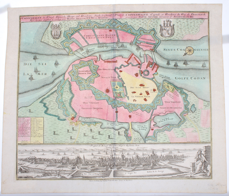
KØBENHAVN - COPENHAGEN. - MATTHIAS SEUTTER.
Coppenhagen die Königl. Dänische Hauptstadt und Residentz Stadt, in Grund Riss.
Augsburg, Verlag bey Tobias Conrad Lotter, (Ca. 1740). 50,5x59,5 cm. Kobberstukket plan over København visende bydelene lige efter den store brand 1728 og med den afbrændte del markeret. Fuld samtidig håndkolorering. Nederst på siden er der et detailleret prospekt af København, ukoloreret. Med våbenskjolde, kompasroser og skibe i søen.
|
|
|
KØBENHAVN - COPENHAGEN. - MATTHIAS SEUTTER.
Coppenhagen die Königl. Dänische Hauptstadt und Residentz Stadt, in Grund Riss.
Augsburg, Verlag bey Tobias Conrad Lotter, (Ca. 1740). 50,5x59,5 cm. Kobberstukket plan over København visende bydelene lige efter den store brand 1728 og med den afbrændte del markeret. Fuld samtidig håndkolorering. Nederst på siden er der et detailleret prospekt af København, ukoloreret. Med våbenskjolde, kompasroser og skibe i søen.
Bookseller reference : 50395
|
|
|
KØBENHAVN - EM. BÆRENTZEN (ILLUSTR.).
Prospect af Kjöbenhavn i Aaret 1520
(København, omkr. 1850). (Ca.20x30 cm.). Tonet litografi af Bærentzen set mod Nørreport. Lettere brunplettet.
|
|
|
KØBENHAVN - EM. BÆRENTZEN (ILLUSTR.).
Prospect af Kjöbenhavn i Aaret 1520
(København, omkr. 1850). (Ca.20x30 cm.). Tonet litografi af Bærentzen set mod Nørreport. Lettere brunplettet.
Bookseller reference : 48233
|
|
|
KØBENHAVN - L. BOTH.
Kaart over Kjöbenhavn. Optaget i Marken og tegnet af Topograph L. Both 1870. 3de omarbejdede Oplag.
(København), Chr. Steen & Söns Forlag, 1870. (51 x 63 cm.). Farvelitograferet kort over København. Lidt revnedannelse i foldningerne, men uden tab. Marginer med smårifter.
|
|
|
Küchlin, Jakob (1820?1885)
Thunersee Richtung Interlaken, Ringgenberg u. Brienzersee
(um 1850). Gouache. Bildgrösse: 34,5 x 48 cm. Blattgrösse: 42 x 55,5 cm. + Wichtig: Für unsere Kunden in der EU erfolgt der Versand alle 14 Tage verzollt ab Deutschland / Postbank-Konto in Deutschland vorhanden +, Abb.
Bookseller reference : 597BG

|
|
|
Küchlin, Jakob (1820–1885):
Thunersee Richtung Interlaken, Ringgenberg u. Brienzersee
(um 1850). Gouache. Bildgrösse: 34,5 x 48 cm. Blattgrösse: 42 x 55,5 cm.
Bookseller reference : 597BG

|
|
|
Kühnow, Friedrich - Blaeu, Joan
Ducatus Silesiae Laurani Delineatio. [Altkolorierter Original-Kupferstich / original colored copper engraving].
o.J. (Friedrich Kühnow, gestorben 1675. Kartograf. oan Blaeu (niederländisch ['jo??n 'bl?u]; deutsch Johannes Blaeu; * 1596 in Alkmaar, Niederlande; ? 28. Dezember 1673 in Amsterdam, Niederlande) war ein niederländischer Kartograf und Kupferstecher. 1654 schuf er den ersten Atlas Schottlands. Sein 1662 erstmals erschienener elfbändiger Atlas Maior gehörte zu den aufwendigsten und teuersten europäischen Atlanten des 17. Jahrhunderts.
Bookseller reference : 15894DB
|
|
|
L´Isle, Guillaume de
Karte von Rußland (map of Russia) mit Moskau im Zentrum.
Amsterdam, Pierre Schenk ohne Jahr [um 1720]. Kolorierte Kupferstich-Karte in der Plattengröße von 49 x 61 cm. An den Rändern stellenweise etwas bestoßen und mit kleinen Einrissen (z. T. hinterlegt).
Bookseller reference : 35072

|
|
 Receive by email
 Download as PDF document
 RSS feed


