|
[EIGHT MANUSCRIPT PROVINCAL COLOR GOUACHE MAPS OF KOREA]
P'ALTO CHIDO OR EIGHT PROVINCES KOREA MAPS. KOREAN PROVINCAL MANUSCRIPT MAPS
Korea late 18th-early 19th century 1780-1810. Eight color gouache pastel tinted maps ca. 57.5 x 90.1 cm.contemporary re-backing very solid clean examples complete set of all provinces hand-painted gouache manuscripts. RARE & OBSCURE . . . . A RARE & COMPLETE SET OF ANTIQUARIAN MANUSCRIPT KOREAN . . . YI PERIOD PROVINCIAL MAPS . . "PALTO CHIDO" OR "EIGHT PROVINCES MAPS" . . . DELUXE ELEPHANT FOLIO SIZE SHEETS . . . HAND-COLORED GOUACHE PASTELS . This is a very RARE & COMPLETE set of eight Korean provincial manuscript maps. Drawn circa 1780-1810 by an unsigned Korean cartographer. These maps are of historical importance giving place names isolating the time frame. . Painted on very thin finely hand-made mulberry-fiber tissue paper contemporary re-backed with a stiff hand-made paper. Beautifully hand-painted & colored in gouache pastels. . The record shows several reliable verities of manuscript maps showing the eight ancient Korean provinces. . Commonly these maps had no title cartographer's name date or other critical bibliographic colophon data. This is a common theme with Korean manuscript maps. . Political divisions of Korea are by and large mostly stable making name comparisons easier. . PROBABLE MAP TITLES INCLUDE: . a. The "SINJUNG-TONGGUK-YOJI-SUNGNAM:" "EIGHT SEPARATE MAPS EACH SHOWING ONE COMPLETE PROVINCE OF THE EIGHT KOREAN PROVINCES similar in intention to the "PALTO CHIDO." . The eight provinces were established during the Chosen dynasty 1392-1910 alternately and commonly called the Yi dynasty. . The eight provinces are from the north to south: . 1. Hamgyong 2. P'yong'an 3. P'yongyang 4. Kangwon 5. Hwanghae 6. Kanghwa 7. Kyongsang 8. Cholla'ungch'ong . During the Sejo reign 1455-68 Yang Songji made the first "P'Alt-do "PALTO CHIDO" type maps of the eight provinces this type and style became the "standard" for future examples. There after his style and format were copied by others for centuries. . b. A second version and style of the above eight provinces maps is called "TONGGUK CHIDO: MAP OF THE EASTERN COUNTRY i.e. KOREA" showing a compressed northern frontier along Manchuria the characteristic "CHONG CH'OK" style. . c. A third similar map: "P'ALDO-CHONGDO: A SINGLE MAP SHOWING THE EIGHT PROVINCES OF KOREA." . These maps are pictorially beautiful and artistically drawn in detail. Graphics expressing a primitive naive folk charm depicts prominent geological landscape features. Mountain ranges hills forests in green streams/rivers blues political district seats distinctively painted cartouches box-like in various differing colors for each province. Roads paddy coastal shore line & islands in blue tints with other features nicely colored. . There are a large number of name throughout each map all written in Hanzi traditional Chinese characters called "Hanja" in Korean as was the common practice at that time for Koreans. There are no Hangul characters at all. The Hanja identify navigational directions names of surrounding ocean harbors beaches geographical names city towns villages mountains rivers roads and the like. . Each of the eight maps illustrates a complete single province. Within each of the various political divisions and boundaries outlined and named. . RARITY OF KOREAN ANTIQUITIES: Antiquarian Korean examples are sparse when compared to items of the same period in China and Japan. Korean works are less than 10% of those created elsewhere. . Fewer Korean items were made survived and preserved. The attrition rate: bad weather unstable ancient mud building structures fires natural disasters earthquakes war and other factors diminished the remaining examples. . Those the numbers that come to marked are steadily reduced while the value continues to appreciate. Many never return to market when acquired by institutions or private collectors who eventually donate to museums. . DATING THESE MAPS: These were mostly undated. . There are three possible methods of dating. . a. BY PLACE NAME: there are details in the reference books about county seat names being colored or put in various kinds of 'boxes' on the map depending on that according to the resources approximate dates can be derived. . b. PAPER TECHNOLOGY & FIBERS: Koreans have been using hand-made mulberry bark and fiber paper from the Zhenguan period AD 627-649 printing Buddhist sutras by woodblocks on similar kinds of paper. . These two technologies papermaking and woodblock printing was transmitted to Japan around 700 AD. . Since that time both Koreans & Japanese have utilized mulberry paper Washi in Japanese to woodblock print and paint a large variety of items including maps books and single page works. . By comparing the paper of these maps with known dated printed Japanese books a very close approximate date can be derived. . These Korean map papers are nearly identical to dated woodblock-printed Japanese examples we have. It is therefore highly possible these maps were painted on hand-made mulberry paper from circa 1780-1810 period. . In ancient times sheet size was limited to a small size then joined to other sheets to create a large size single sheet. These maps are of that format. See McCune below where he states the kind of paper used which matches our examples. . CONDITION: Per McCune we summarize: as usual these maps were folded several times from their creation time so they could be safely stored and carried in small 'book' format in covers with a tied string. See McCune below. . Being painted on very fine & thin hand-made mulberry paper most all examples were eventually re-backed. Ours as typical have period re-backing using the same character hand-made mulberry fiber paper of a thicker quality. . They are well preserved however nevertheless as usual there remains some old original wear at the folds the expected light water stains dustiness with other typical very minor flaws for an item of this grand size being 200 years old. These do not detract from the overall excellent impression and stunning appeal. . RARITY: . The complete set is RARE! The work is nicely executed in a firm hand with artistic value illustrating artistically hills mountains and other features of the map pictorially. It is not only a map but a work of art. Tastefully colored in subtle pastels nice representation of water rives and sea. . Such early and beautifully artistic examples seldom come to market. . A RARE AND FRESH EXAMPLE NEVER BEEN ON THE MARKET IN THE LAST 120 YEARS ! . PROVENANCE: These items were acquired from a former missionary's estate who was stationed in Korea from circa 1900-1930's. They have been in this private collection since and have never been on the market. . Color scans are posted to our website. . REFERENCES: . TOOLEY Ronald V. et al.: Article: Shannon McCune: SOME KOREAN MAPS pp.70-102 with illustrations. McCUNE Shannon.: KOREAN MAPS OF THE YI DYNASTY KOREAN CULTURE Korean Consulate General L.A. Ca. Sept. 1983 pp.21-31 34 back cover color plate color & b.w. illustrated. . He discusses "PALTO CHIDO""EIGHT PROVINCES MAP" origins maps without scale and were copies of a Korean scholar named Won his title was: Haksaeng works based on Chong Choks 1390-1475 TONGGUK CHIDO MAP OF THE EASTERN COUNTRY then modified by Won to be the more typical "PALTO CHIDO" "EIGHT PROVINCES MAP" but in his new style. This new style clearly resembles our maps in layout format color of county seats and similar boxes around them and other critical details. KOREAN CONSUL GENERAL KOREAN CULTURE September 1983 pp.21-31 34 color map on back cover color and b.w. illustrated. . It was from these maps that the later versions similar to ours eventually emerged mostly by Imperial Order by the ".Yi Dynasty court specifically decreed that both magistrates and governors should prepare up-to-date maps of their territories udder their supervision." p.25. HARLEY J.B. ed. et al.: CARTOGRAPHY IN THE TRADITIONAL EAST AND SOUTHEAST ASIAN SOCIETIES. Ahead of Title: THE HISTORY OF CARTOGRAPHY Vol. 2 Book 2 an excellent article by Gari Ledyard: CARTOGRAPHY IN KOREA pp. 235-345239 figures 10.23 10.24 et al. NAKAMURA Hiroshi.: EAST ASIA IN OLD MAPS. . --. NIHON KO CHIZU TAISEI: GREAT COLLECTION OF OLD JAPANESE MAPS MONUMENTA CARTOGRAPHICA JAPONICA . --. OLD CHINESE WORLD MAPS PRESERVED BY THE KOREANS. Article in IMAGO MUNDI IV 1958. LEE Chan. CH'AN Yi.: OLD MAPS OF KOREA. Han'guk ko chido. By: Ch'an Yi Hong-gyu Che Han'guk Tosogwanhak Yon'guhoe. He discusses and illustrates a good number of similar examples. On pp.226-27 he outlines an early Yi Dynasty example of: THE MAP OF EIGHT provinces found in TONGGUK YOJI SUNGNAM Chong Sang-gi's Tongguk Chido. These manuscripts were on large paper one province per sheet. Many other fine related examples are illustrated & discussed. . --. OLD MAPS OF KOREA: HISTORICAL SKETCH. He traces the early origins of Early Yi dynasty1392-1910 Eight Provinces Map origins and progressions excellent lucid article with illustrations and references to Yi HOEs MAP OF EIGHT PROVINCES. Excellent essay on provincial maps. SHIN Michael D. ed.: KOREAN HISTORY IN MAPS: From Prehistory to the Twenty-First Century. British Museum similar examples cited: commons.wikimedia.org/wiki/Category:Room_67_British_Museum# /media/File:Map_of_the_Jeolla_Province_British_Library_c.27. f.14_fol.12_n02.jpg Library of Congress: https://www.loc.gov/item/84117116 THROWER NORMAN J.W. & Young Il Kim: dong-kookyu-do: A RECENTLY DISCOVERED MANUSCRIPT OF A MAP OF KOREA. Imago Mundi vol.21 1967 pp.31-49 illustrated. . . unknown
Riferimento per il libraio : 38009901

|
|
|
[ENGLISH COUNTY MAPS]
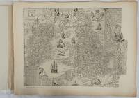
English County Maps in the Collection of the Royal Geographical Society. Reproductions of Early Engraved Maps II.
London.: Royal Geographical Society. 1932. Twenty one loose maps with tissue guards printed on sheets 49.5 x 63.5 cm in the original folio title-wrappers the maps with some edge wear and toning but on the whole in very good condition the wrappers browned and stained torn with minor loss at the foot of the title wrapper small closed edge tears now re-enforced with archival material and sound. Lacking the introductory notes by Edward Heawood. The complete suite of maps: an impressive production. The first map is a general map of England and Ireland by an unknown author 1594; nineteen county maps; and a final sheet of miniature county maps printed as a deck of playing-cards. The county maps proper vary in date from Saxton's “Southamtonia” of 1575 to John Speed's version of Norden's map of Sussex dated 1610. A contemporary reviewer dubbed it " a rich cartographical feast" allowing easy access to rare and valuable maps and comparison of maps by different cartographers for the same county. <br>The county maps reproduced include five by Christopher Saxton three by John Norden Philip Symonson's map of Eastern Kent published in 1596 a series of seven maps dating from the early years of the seventeenth century two maps prepared for Camden and two published by John Speed. . Royal Geographical Society unknown
Riferimento per il libraio : 176499
|
|
|
[ENVER] NECDET EGERAN, (1907-2005).
[GEOLOGICAL MAP of RAMAN OIL FIELD] Geological map of Ramandag.= Ramandag Petrol Sahasi jeolojik hartasi [sic. haritasi].
Very Good Turkish Original b/w folded geological map of Ramandag oil field / area in Mardin and Batman. Oblong folio. (38 x 59 cm). Legends in Turkish; bilingual title in English and Turkish. It shows Raman oil field in Mardin and Batman cities of Southeast Anatolia, and Dicle River (Tigris). on south. Rare.
|
|
|
[ENVER] NECDET EGERAN, (1907-2005).
[THE GEOLOGICAL MAP-MAKING] Tatbikî jeoloji I: Jeolojik harta [sic. harita] alma usulleri.
Very Good Turkish Paperback. Demy 8vo. (21 x 15 cm). In Turkish. 191, [1] p., 1 folded huge map (39x75 cm). Tatbikî jeoloji I: Jeolojik harta [sic. harita] alma usulleri. Enver Necdet Egeran was born in Cyprus in 1907. He, High school education in Cyprus, High Mining Engineering in Turkey, the Mineral and Petroleum Geology High Engineering and PhD in the same subject, completed in France. He was sent to France by Mustafa Kemal Atatürk. He served in the bureaucracy for 25 years, led the Mining and Petroleum exploration and made the first oil available in Raman. After retiring from the state, after being the General Manager of an American oil company for 12 years, he managed his own consulting company for 23 years. Rare. Only one copy in OCLC 850735753 (Istanbul Technical University).
|
|
|
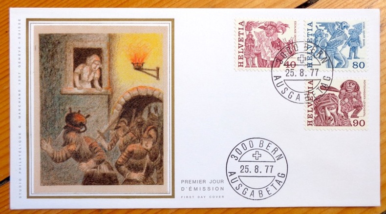
[Escalade]:
Escalade - La Mère Royaume.
Studio philatélique G. Marchand, 1977. Enveloppe au format 16,6 x 9 cm., ornée d'une belle vignette en soie représentant la Mère Royaume et sa marmite en plein action. 3 timbres, affranchissement philatélique, premier jour d'émission (25.8.1977). A l'état de neuf.
Riferimento per il libraio : 3980
|
|
|
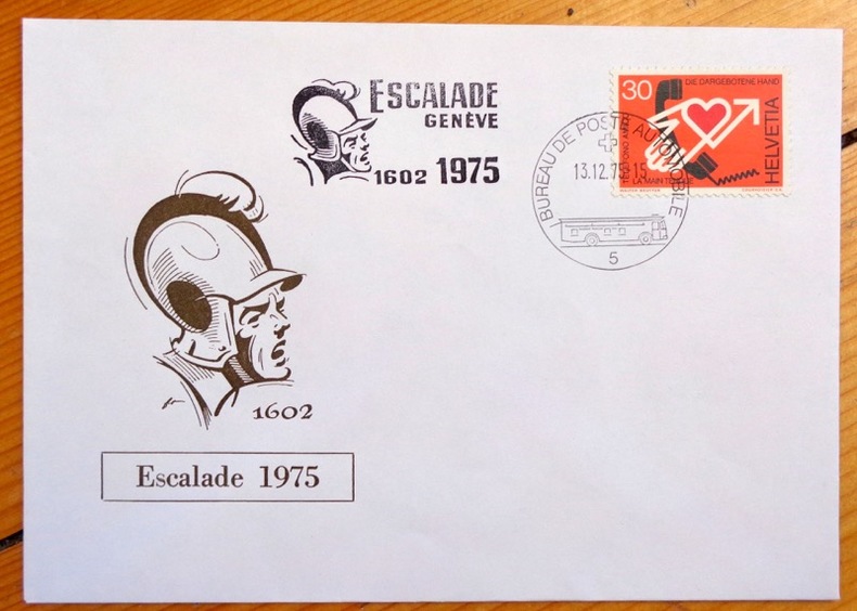
[Escalade]:
Escalade 1602 -1975.
Enveloppe au format 16 x 11 cm., ornée d'une vignette et d'un timbre, affranchissement philatélique (13.12.1975) à l'occasion de l'Escalade 1975.
Riferimento per il libraio : 3976
|
|
|
[FERCHAULT DE REAUMUR, DUHAMEL DU MONCEAU dir.] DUHAMEL DU MONCEAU
[Description des arts et métiers faites ou approuvées par Messieurs de l'Académie royale des sciences] Art du cartier.
1762 in-folio [A Paris, chez SAILLANT & NYON, DESAINT,] imprimerie L. F. DELATOUR, 1762, 1 volume in-folio de 285x430 mm environ, (1) f., page de titre, 38 pages, complet des 5 planches in-fine. Demi-basane havane postérieure, dos long portant titres et ex libris dorés, tranches mouchetées, gardes blanches. Cuir épidermé par endroits, étiquette papier sur le dos, ex libris au crayon sur la page de titre, quelques rousseurs et brunissures marginales, sinon bon état général.
Riferimento per il libraio : 118658

|
|
|
[FERDINAND Franz]:
Tagebuch meiner Reise um die Erde 1892 - 1893.
Wien, Alfred Hölder, 1895. 2 volumes in-4 de VII-573et [2]-565 pages, pleine percaline verte, dos à 5 petits nerfs ornés de fleurons, filets, titre et tomaison dorés, filet doré encadrant les plats, initiales de l'auteur couronnées au coin supérieur des premiers plats, tranches teintées.
Riferimento per il libraio : 15658
|
|
|
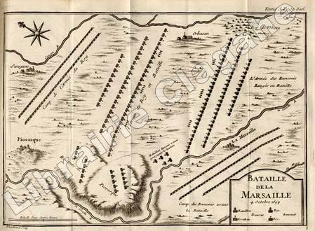
[Feuquières, Antoine de Pas, marquis de]
Mémoires de M. le Marquis de Feuquière, lieutenant-général des armées du Roi ; Contenant ses Maximes sur la Guerre, et l'application des Exemples aux Maximes.
Londres et Paris, Ch. Ant. Jombert, 1775 ; quatre tomes, in-12 ; plein veau fauve marbré, dos décorés et dorés, pièces de titre grenat et de tomaison havane, filet sur les coupes, tranches rouges (reliure de l'époque) ; (2), CCVIII (Avertissement et Vie de M. le marquis de Feuquière), 226 pp., (1) f. bl. ; (1) f. bl., (2), 402 pp., (1) f. bl. ; (1) f. bl., 387 pp., (1 bl.) ; (2), 444 pp. et en tout 13 planches dépliantes hors-texte dont 2 cartes et 11 plans de batailles.
Riferimento per il libraio : 9222
|
|
|
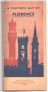
[Florence]; [Italy]; [Maps]; [Travel]
A Visitor's Map of Florence with the Compliments of Hotel Baglioni & Palace Florence
Firenze Florence: Remo Bellini & Figli 1955. Map. Very Good. 43.3 cm x 64 cm. unfolded. Single sheet folded seven times into a map. Printed in orange brown green and black. A map from the Hotel Baglioni still in operation today. The map advertises banks gift shops museums pharmacies and other services in Florence. Four splits to the center fold very subtle two ink annotations. Remo Bellini & Figli unknown
Riferimento per il libraio : 000014645
|
|
|
[Folding Maps]
Africa Orientale Italiana. 12 of 37 unbound folded four-page Tav. tables/sheets: Tav. 3 - Cassala; Tav. 4 - Asmara; Tav. 5 - Hodeida; Tav. 6 - Gallabat: Tav. 8 - Assab; Tav. 9 - L. Tana; Tav. 11 - Gibuti; Tav. 14 - Neggio; Tav. 17 - Berbera; Tav. 20 - Gimma; Tav. 25 - L. Stefania; Tav. 30 - L. Rodolfo
Milano: Touring Club Italiano 1936. Very Good. 12 of 37 unbound sheets. 4p.center 2 pages are 34 cm. x 25 cm. map. Partly colored. Scale: 1:1000000. Italian text. Touring Club Italiano unknown
Riferimento per il libraio : 91525

|
|
|
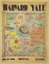
[Football] [Game] [Maps] Held, John (Jr.); Edited by Charles E. Thorp
Harvard-Yale November 24 1928
Yale University Athletic Association. Good. 160pp. Thin quarto 31 cm The front wrap is detached but present. The rear wrap is absent. Two small closed tears to the fore-edge of the front wrap. Scarce. Cover art by Utah artist John Held Jr.<br /> <br /> Utah Artist John Held Jr. 1889-1958 was a prominent illustrator of the 1920s and 1930s. He began by drawing sports and political drawings for The Salt Lake Tribune when he was just 16 years old. Held moved to New York City in 1910 where he went on to gain notoriety for his drawings in the popular magazines "Life" "The New Yorker" "Vanity Fair" "Judge" and "College Humor." His work epitomized the Jazz Age. He is most recognized for creating the short-haired "flapper."<br /> <br /> The cover of this publication features one of Held's maps. Held's maps illustrate the diversity of his art while at the same time serving to demonstrate Held's interpretation of various notable places and things. Kori Alexander writes in his article entitled Relevant Magic in the Art of John Held Jr. "While it was Held's caricatures of the young college chaps and flapper girls that earned him public notoriety it was his linoleum cuts and pen and ink maps that fortified his legitimacy as a social commentator." Virginia Commonwealth University website. Yale University Athletic Association unknown
Riferimento per il libraio : 66643
|
|
|
[Frankreich] - Schrämbl, F. A.
Neueste Generalkarte von Frankreich nach den bessten bisher bekanntgemachten Karten und nach den in Frankreich gemessenen Triangeln. Verfasst von Herrn Cassini de Thury [...]. Wien, [Joseph Philipp Schalbacher], 1790.
4 (statt 6) grenzkolorierte Kupferstiche, je ca. 864:635 mm (Plattenmaß 748:536 mm). Frankreichteil aus dem Schalbacher-Schrämbl'schen "Großen Allgemeinen Atlas" (1786-1803; hier Bll. Nr. 29-33). Es fehlen Bl. 30 (Elsaß, Lothringen, Champagne, Picardie, Artois) und Bl. 34 (Südfrankreich). Gestochen von I. W. Engelmann; Maßstab ca. 1:680.000. - Im breiten w. Rand minimal angestaubt bzw. kl. Einrisse, sonst sauberes, gutes Exemplar. Dörflinger/Hühnel I, 134, 29-33.
|
|
|
[GALLIPOLI - ANTIQUE MAP] DUMAS-VORZET, E; GERIN, A. (ENGRAVER); GERMAIN, A (HYDROGRAPHER)
Abords et Entrée des Dardanelles. Mer Mediterranée.
Paris.: Service hydrographique et océanographique de la marine. 1883 but1894. Engraved hydrographical chart on watermarked double sheet 99 x 63 cm soundings in metres lighthouses picked out in yellow and red inset map of the port and town of Tenedos central fold a few very slight edge tears to the generous margins light spotting and surface soiling but in very good condition. Fine and impressive large naval chart of this strategically important strait then still under the control of the Ottoman Empire. <br> <br>From a private collection; "Lord John Fitzroy Royal Yacht Squadron" in manuscript on the verso. . Service hydrographique et océanographique de la marine unknown
Riferimento per il libraio : 178272
|
|
|
[GENERAL DRAFTING COMPANY]. ネラル・ドラーフティング株式会社.
アメリカ合衆國.主要地方資源産物及び風景絵入り地図. Amerika Gasshūkoku. Shuyō chihō shigen sanbutsu oyobi fūkei eiri chizu. Pictorial Map of the United States of America Showing Principal Regional Resources Products and Natural Features.
Washington D.C.: 国務省. Kokumishō. No date. circa1955. Large folding Japanese coloured map of the United States with 3 inset maps at foot of map showing main railways air and highway routes and hemispheres at the top right. Some browning mainly visible on reverse still a good copy. 66 x 81cm. An intricate and detailed pictorial map of the United States published in Japanese by the US State Department. The same type of map had been published since 1945 in English and subsequently in other languages. The Japanese language map is hard to find. The map is undated but was probably produced in the 1950's. The images include depictions of women board riders in two piece swimsuits of the sort popular in the 1950s but the inset text lists Alaska and Hawaii as external territories of the US indicating that the map was produced before they attained statehood in 1959. <br> <br>An inset panel provides information on the area and population of the US the population of major American cities mineral and other resources climate and topography. A note at the bottom right hand corner of the map states that copies of the map can be obtained free of charge from your nearest US Information Office. <br> <br>Every region of the country is decorated with an illustration of the natural resources industries or cultural or historical resources associated with that particular place. These include images of early colonial settlers the birthplaces of Mark Twain and Woodrow Wilson Booker T. Washington's house and Abraham Lincoln's grave; images of major dams oil fields coal mines cotton plantations etc. various animals and crops and images of ships cars and public buildings including the Statue of Liberty located rather oddly far out at sea. . 国務省. [Kokumishō]. unknown
Riferimento per il libraio : 172003

|
|
|
[Genève] :
"Genève à pied" - D'amont en aval. Entre technique et nature.
Ville de Genève, 2000. Plan dépliant à emmener pour découvrir Genève à Pied.
Riferimento per il libraio : 17373

|
|
|
[Genève] :
"Genève à pied" - D'ici et d'ailleurs. Entre travail et loisirs.
Ville de Genève, 2001. Plan dépliant à emmener pour découvrir Genève à Pied.
Riferimento per il libraio : 17372

|
|
|
[Genève] :
"Genève à pied" - De corps en coeur. Entre urbanisme et santé.
Ville de Genève, 2002. Plan dépliant à emmener pour découvrir Genève à Pied.
Riferimento per il libraio : 17370

|
|
|
[Genève] :
"Genève à pied" - De site en musée. Au coeur de son patrimoine.
Ville de Genève, 1997. Plan dépliant à emmener pour découvrir Genève à Pied.
Riferimento per il libraio : 17374

|
|
|
[Genève] :
"Genève à pied" - De ville en ville. Du Lac à L'Arve.
Ville de Genève, 1999. Plan dépliant à emmener pour découvrir Genève à Pied.
Riferimento per il libraio : 17371

|
|
|
[Genève] :
Les maisons rurales de la campagne genevoise / Sites naturels et cours d'eau de la campagne genevoise. 9 / 8 circuits-promenades avec plans.
République et Canton de Genève / Société de Banques Suisses, 1989 / 1991. 2 plans commentés.
Riferimento per il libraio : 14429

|
|
|
[Genève] :
Sites naturels et cours d'eau de la campagne genevoise en 8 circuits-promenades avec plans.
République et Canton de Genève / Société de Banques Suisses.
Riferimento per il libraio : 23846

|
|
|
[Genève]:
Genève - Le port des Eaux-Vives avec l'ancien jet d'eau (hauteur 90 m.) vers 1910.
Vue photographique, encadrée, format du cadre 26 x 20 cm.
Riferimento per il libraio : 26123

|
|
|
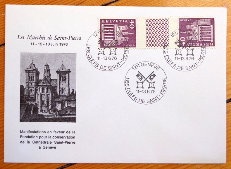
[Genève]:
Marchés de Saint-Pierre, Genève.
Les Clefs de Saint-Pierre, 1976. Enveloppe au format 16 x 11 cm, affranchissement philatélique, parue à l'occasion des « Marchés de Saint-Pierre ». Cette grande kermesse populaire trouvait place dans une série de manifestations organisées pour tenter de réunir les fonds nécessaires au financement des grands travaux de restauration prévus à la cathédrale. Sous l'égide des « Clefs de Saint-Pierre », mention indiquée sur les tampons.
Riferimento per il libraio : 4509
|
|
|
[Genève]:
Vieux Genève.
Carte postale du bistro, petit pli au coin inférieur. Encadrée, format du cadre 10 x 14 cm.
Riferimento per il libraio : 26122

|
|
|
[Geografa]
CARTA AUTOMOBILISTICA KOMPASS "ITALIA NORDOCCIENTALE"
Carte géographique format ouvert 1130 x 840 mm, s.d., Geografa, bon état
Riferimento per il libraio : LFA-126737264
|
|
|
[Germany]; [Pocket Travel Guides]; [Maps]
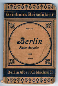
Berlin; Kleine Ausgabe = Small Edition
Berlin: Albert Goldschmidt 1913. Reprint. Pamphlet. Good. 12mo. 36.5 cm x 24 cm. 2 pages of publisher's advertisements 3 4-114 2 4 pages of publisher's advertisements pp. Light brown wraps printed in blue. Price of 1 Mark on the front wrapper. Illustrated with four maps three folding. With excerpts from the 57th edition. Book 25 in a series of travel guides. Lacks the final map torn away a name on the front wrapper. Albert Goldschmidt unknown
Riferimento per il libraio : 000012875
|
|
|
[GIBSON John]:
The modern traveller being a collection of useful and entertaining travels, lately made into various countries; the whole carefully abridged : exhibiting a view of the manners, religion, government, arts, agriculture, manufactures, and commerce of the known world Illustrated with maps and ornamental views.
London, Printed for T. Lowndes, 1776-1777. 5 volumes in-12 (sur 6) de [4]-282-[2]; [4]-283; [4]-284; [2]-285-[3] et [2]-287 pages, plein veau blond, dos à 5 petits nerfs ornés de filets, roulettes, tomaison et titre dorés, étiquettes de titre bordeaux, roulette dorée sur les coupes. dos frottés, petit manque à 2 coiffes supérieures, un mors fendu sur 2 cm au vol.4, 2 petits manques de peau au vol. 2, 2 ex-libris par volume.
Riferimento per il libraio : 10256

|
|
|
[Globe - Terrestrial]. Malby & Co.
Malby’s terrestrial globe. [London], Malby & Co. (engraved by Chas. Malby), 1 January 1848.
Diameter: 45.5 cms (18 inch), height in stand: 64.5 cm. An engraved terrestrial globe with 12 gores and 2 polar caps over a plaster-covered core, and the engraved horizon ring on the wooden stand, all coloured by a contemporary hand. In a contemporary wooden stand with 3 turned legs supporting the horizon ring, and 3 turned stretchers with a cylindrical centrepiece with a knob on the underside. Further with a contemporary brass hour circle and a slightly later iron meridian ring (and probably the axis pivots). Only recorded copy of the 1848 edition (preceded only by one recorded copy of the 1846 edition) of Malby’s 18 inch (45.5 cms) terrestrial globe, the largest he engraved and much rarer than his 12 inch globe. “Debai” (Dubai) is shown on the Gulf coast, only 15 years after the al-Maktoum dynasty took charge of it in 1833. The globe seems to be intended especially for navigational use, with not only a grid of parallels and meridians (with the prime meridian through Greenwich), but also the irregular curved lines indicating the variation of magnetic from geographic north (“isogones”), at 5 degree intervals. From these one can clearly see where the magnetic poles were. Malby seems to be the first and almost the only globe maker to show them. The engraver signed the present globe “Chas. Malby” and signed the 12 inch globe of 1845 described by Dekker “C. I. Malby”. He must therefore have been Charles Isaac Malby (1816-post 1868). Thomas Malby, Charles’s brother, first set up as a globe publisher around 1839 and was trading as Malby & Co by 1841. Charles may have engraved nearly all of his globes. The earliest Malby globe known to survive is dated 1842, but his earliest recorded 18 inch globes are a pair at the Mariners’ Museum in Virginia: the celestial globe dated 1843 and the terrestrial globe dated 1846. The Austrian National Library has an 18 inch Malby terrestrial globe dated 1850, but we find no further example until 1872. The present 1848 example appears to be unique. The horizon ring has an owner’s stamp on the printed surface, nearly due east, apparently a coat of arms in a wreath, but difficult to make out. The horizon ring and globe have a dozen small cracks repaired and a few small gaps in the surface image, some repaired, but are otherwise in good condition. Extremely rare and lovely large globe, with the fascinating and unusual graphic presentation of geomagnetism. Cf. British Library online cat. BLL01013005847; Dekker, GLB0081; Dunn & Wallis, British globes up to 1850 (1999) 209 & 443; World in your hands (Rudolph Schmidt coll.) 7.12 & 7.13; Yonge, Early globes (1968), p. 46.

|
|
|
[GOLDEN GATE INTERNATIONAL EXPOSITION -- PICTORIAL MAPS/WOMEN ARTISTS] TAYLOR [WHITE], Ruth; [BURROUGHS, Walter (Man. Ed.) & TI
Official guide book Golden Gate International Exposition World’s Fair. . . A cartograph of Treasure Island in San Francisco Bay: Golden Gate International Exposition. . . .
San Francisco CA: San Francisco Bay Exposition 1939. 8vo. 116 pp. With oblong folio. 19.25 x 16 in. colour pictorial map frontisp. detailed sections of island and exhibits in blue on verso fold creases numerous photo illustrations text maps diagrams stepped thumb tabs at outer fore-edge. Blue-cloth backed softcovers featuring the striking Art Deco cover art by Simon “Si†Vanderlaan 1904-1986 famed pin-up artist and illustrator who worked for Walt Disney studios during World War II minor scuffing very minor age toning shelfwear still VG bright copy from the library of Prof. Marvin Nathan. Revised 1939 edition of this excellent guide to the first year in 1939 of the Golden Gate International Exposition including “Cartograph†revealing all of the Art Deco architectural wonders and surrounding areas of Treasure Island. The pictorial maps were issued separately as well as with the “Official Guide Books.†Ruth Taylor White’s 1902-1985 delightful pictographic maps or cartographs included depictions of the Territory of Hawaii in which she had driven or traveled to every corner of the Islands and the Grand Canyon for her for her brother’s book “Grand Canyon Country.†Later Little Brown requested an entire atlas which was published as the very scarce Our U.S.A. “A gay geography.†Her cartographs influenced the style of American cartographic illustration for decades afterwards. See: Griffin Mapping Wonderlands: Illustrated Cartography pp. 192-193; Field MapCarte 29/364: Our U.S.A. A Gay Geography 2014. San Francisco Bay Exposition, paperback
Riferimento per il libraio : 60959
|
|
|
[Goodacre, William (after)].
Die natürliche Brücke in Virginien: Vereinte Staate. [Austria?, ca. 1840s-1850s].
Pen, black ink and watercolour on paper (590 x 440 mm), framed in a passe-partout (755 x 580 mm). Large, high quality watercolour of the Natural Bridge in Rockbridge County, Virginia. This natural arch spanning 27 meters was, along with Niagara Falls, one of the most popular tourist attractions in the United States in the late 18th and early 19th century. As an old natural wonder in a young country, it played an integral part in the formation of America's national identity and was "certainly a worthwhile side trip for travelers who hoped to experience the sublime quality of the American landscape" (Howat). The sublime aspect is often present when from the 1830s onward artists start depicting the Bridge: as in the present watercolour, where small figures are placed in the foreground to show the massiveness of the 88-meter geological formation. - The view shown in the present watercolour appeared as an engraving in John Howard Hinton's History and topography of the United States (1832) after a drawing made by the American landscape painter William Goodacre (1803-83). The image was widely pirated and imitated and appeared in numerous other publications, including Meyer's Universum in 1837, with a caption identical to the one on the present watercolour. The anonymous artist probably copied the image from the 1837 publication, but made several changes, simplifying most of the foliage but adding the large fern, duplicating the kneeling hunter and adding an extra deer. Interestingly, the engraving shows a tree peering out from behind the bridge, pencilled in outline, but never painted in. - From an Austrian private collection. In very good condition. Howat et al., American Paradise, pp. 272-274. Kastning, Natural Bridge, p. 20. Cf. Sears, Sacred places.
|
|
|
[GRAVURE] - ANONYME
Coste du nord est de l'isle de Juan-Fernandez.
Paris, s.e., s.d. (vers 1750); 250/325 mm, 1 pp., une feuille. Carte provenant certainement d'un livre de voyage du XVIIIème siècle. Bon état.
|
|
|
[GRAVURE] - ANONYME
Coste du nord est de l'isle de Juan-Fernandez.
Paris, s.e., s.d. (vers 1750) ; 250/325 mm, 1 pp., une feuille. Carte provenant certainement d'un livre de voyage du XVIIIème siècle. Bon état.
Riferimento per il libraio : A163
|
|
|
[GRAVURE] - ANONYME
Kan Kang Hyen, près de Kan Cheu Fu.
Paris, s.e., s.d. (vers 1750); 165/175 mm, 1 pp., une feuille. Planche provenant très certainement d'un livre de voyage du XVIIIème siècle. Bon état.
|
|
|
[GRAVURE] - ANONYME
Kan Kang Hyen, près de Kan Cheu Fu.
Paris, s.e., s.d. (vers 1750) ; 165/175 mm, 1 pp., une feuille. Planche provenant très certainement d'un livre de voyage du XVIIIème siècle. Bon état.
Riferimento per il libraio : A164
|
|
|
[GRAVURE] - ANONYME
Plan de la ville de Syracuse assiégée par les athéniens.
Paris, s.e., s.d. (vers 1750); 220/265 mm, 1 pp., une feuille. Plan provenant certainement d'un livre de voyage du XVIIIème siècle. Bon état.
|
|
|
[GRAVURE] - ANONYME
Plan de la ville de Syracuse assiégée par les athéniens.
Paris, s.e., s.d. (vers 1750) ; 220/265 mm, 1 pp., une feuille. Plan provenant certainement d'un livre de voyage du XVIIIème siècle. Bon état.
Riferimento per il libraio : A167
|
|
|
[GRAVURE] - ANONYME
Plan du combat naval d'Ecnome.
Paris, s.e., s.d. (vers 1750); 170/220 mm, 1 pp., une feuille. Plan provenant d'un livre de voyage du XVIIIème siècle. Bon état.
|
|
|
[GRAVURE] - ANONYME
Plan du palais et citadelle des rois incas.
S.l., s.e., s.d. (vers 1750); 255/185 mm, 1 pp., une feuille. Plan provenant certainement d'un livre de voyage du XVIIIème siècle. Bon état.
|
|
|
[GRAVURE] - ANONYME
Plan du palais et citadelle des rois incas.
S.l., s.e., s.d. (vers 1750) ; 255/185 mm, 1 pp., une feuille. Plan provenant certainement d'un livre de voyage du XVIIIème siècle. Bon état.
Riferimento per il libraio : A169
|
|
|
[GRAVURE] - ANONYME
Plan profil et élévation des deux pyramides (Pérou).
Paris, s.e., s.d. (vers 1750); 255/195 mm, 1 pp., une feuille. Plan provenant certainement d'un livre de voyage du XVIIIème siècle. Bon état.
|
|
|
[GRAVURE] - ANONYME
Plan profil et élévation des deux pyramides (Pérou).
Paris, s.e., s.d. (vers 1750) ; 255/195 mm, 1 pp., une feuille. Plan provenant certainement d'un livre de voyage du XVIIIème siècle. Bon état.
Riferimento per il libraio : A160
|
|
|
[GRAVURE] - ANONYME
Signaux par le feu.
Paris, s.e., s.d. (vers 1750); 220/160 mm, 1 pp., une feuille. Planche provenant certainement d'un livre de voyage du XVIIIème siècle. Bon état.
|
|
|
[GRAVURE] - ANONYME
Signaux par le feu.
Paris, s.e., s.d. (vers 1750) ; 220/160 mm, 1 pp., une feuille. Planche provenant certainement d'un livre de voyage du XVIIIème siècle. Bon état.
Riferimento per il libraio : A170
|
|
|
[GRAVURE] - CARTE
Allemagne, l'empire Autrichien, le royaume de Prusse, la confédération germanique.
Paris, Delamarche, 1838; 336/475 mm, 1 pp., une valeur. Carte provenant d'un atlas du 19ème siècle. Bon état.

|
|
|
[GRAVURE] - CARTE
Allemagne, l'empire Autrichien, le royaume de Prusse, la confédération germanique.
Paris, Delamarche, 1838 ; 336/475 mm, 1 pp., une valeur. Carte provenant d'un atlas du 19ème siècle. Bon état.
Riferimento per il libraio : A83
|
|
|
[GRAVURE] - CARTE
Carte des environs d'Issus (Turquie, Irak, Syrie).
Paris, s.e., s.d. (vers 1750); 165/205 mm, 1 pp., une feuille. Bon état. État correct.
|
|
|
[GRAVURE] - CARTE
Carte des environs d'Issus (Turquie, Irak, Syrie).
Paris, s.e., s.d. (vers 1750) ; 165/205 mm, 1 pp., une feuille. Bon état. État correct.
Riferimento per il libraio : A193
|
|
|
[GRAVURE] - CARTE
Conquêtes d'Alexandre.
Paris, Delamarche, 1838; 336/475 mm, 1 pp., une feuille. Carte du monde d'Alexandre le grand. Bon état.
|
|
|
[GRAVURE] - CARTE
Conquêtes d'Alexandre.
Paris, Delamarche, 1838 ; 336/475 mm, 1 pp., une feuille. Carte du monde d'Alexandre le grand. Bon état.
Riferimento per il libraio : A86
|
|
 Ricevere i risultati per e-mail
 Scaricare i risultati in PDF
 RSS feed


