|
Harvey Maps
Wales Coast Path Map 2 - Caernarfon to Cardigan XT40
like new. unknown
Bookseller reference : 45750842 ISBN : 1851376615 9781851376612
|
|
|
Harvey Maps
Wales Coast Path 3 Map - Cardigan to Llanelli XT40
Harvey Maps 2023. Map. New. 1st ed april 2023 edition. 2 pages. 9.49x8.31x0.39 inches. Harvey Maps unknown
Bookseller reference : __1851376623 ISBN : 1851376623 9781851376629
|
|
|
Harvey Maps
Wales Coast Path Map 2 - Caernarfon to Cardigan XT40
Harvey Maps 2023. Map. New. 1st ed april 2023 edition. 2 pages. Chinese language. 9.49x4.65x0.43 inches. Harvey Maps unknown
Bookseller reference : __1851376615 ISBN : 1851376615 9781851376612
|
|
|
Harvey Maps
West Lothian Street Atlas: Including Livingston Linlithgow and Bathgate Harvey: Including Livingston Linlithgow and Bathgate Harvey
Paperback. Very Good. paperback
Bookseller reference : GOR002860200 ISBN : 1851374469 9781851374465
|
|
|
Harvey Maps
Yorkshire Dales Outdoor Atlas Harvey Outdoor Atlas
Harvey Map Services Ltd 2004. Paperback. New. 112 pages. 9.40x5.80x0.50 inches. Harvey Map Services Ltd paperback
Bookseller reference : 2-1851374957 ISBN : 1851374957 9781851374953
|
|
|
Harvey Maps
Yorkshire Dales: Dales North : Wensleydale and Swaledale
paperback. Good. Access codes and supplements are not guaranteed with used items. May be an ex-library book. paperback
Bookseller reference : 1851374701.G ISBN : 1851374701 9781851374700

|
|
|
Harvey Maps
Yorkshire Dales Outdoor Atlas
paperback. Good. Access codes and supplements are not guaranteed with used items. May be an ex-library book. paperback
Bookseller reference : 1851374957.G ISBN : 1851374957 9781851374953
|
|
|
Harvey Maps
Yorkshire Dales North West Ultramap
Harvey Map Services Ltd 2016. Map. New. 1 pages. 7.32x3.78x0.31 inches. Harvey Map Services Ltd unknown
Bookseller reference : 2-1851375813 ISBN : 1851375813 9781851375813
|
|
|
Harvey Maps
Yorkshire Wolds Way Trail map
Harvey Maps 2017. Map. New. 1 pages. 9.84x5.75x0.08 inches. Harvey Maps unknown
Bookseller reference : 2-1851375929 ISBN : 1851375929 9781851375929
|
|
|
Harvey Maps
Yorkshire Dales for Cyclists
Harvey Maps 2015. Map. New. 1 pages. 9.76x5.43x0.24 inches. Harvey Maps unknown
Bookseller reference : 2-1851375570 ISBN : 1851375570 9781851375578
|
|
|
Harvey Maps
Yorkshire Dales: Dales North: Wensleydale and Swaledale Outdoor Map
Harvey Map Services Ltd 2003. Paperback. New. 1 pages. 9.37x4.65x0.24 inches. Harvey Map Services Ltd paperback
Bookseller reference : 2-1851374701 ISBN : 1851374701 9781851374700
|
|
|
Harvey Maps
Yorkshire Dales: Dales North: Wensleydale and Swaledale
Paperback. Acceptable. paperback
Bookseller reference : GOR008250293 ISBN : 1851374701 9781851374700

|
|
|
Harvey Maps
Yorkshire Dales: Dales North: Wensleydale and Swaledale
Paperback. Very Good. paperback
Bookseller reference : GOR006353257 ISBN : 1851374701 9781851374700

|
|
|
Harvey Maps
Yorkshire Dales Outdoor Atlas Harvey Outdoor Atlas
Paperback. Very Good. paperback
Bookseller reference : GOR006100802 ISBN : 1851374957 9781851374953

|
|
|
Harvey, Sir Paul compiled & edited, with illusts & Maps
Oxford Companion to Classical Literature The
Oxford at Clarendon Press. HBDJ bkplate 1962 minor rub chip & soil VG/VG AS-IS. Hard Cover. Oxford at Clarendon Press hardcover
Bookseller reference : 3902
|
|
|
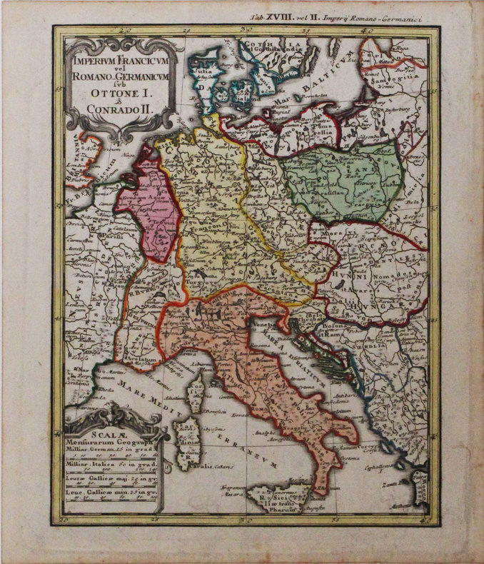
HASE (Johann Matthias).
Imperium Francicum vel Romano-Germanicum sub Ottone I & Conrado II.
1746. 217 x 168 mm.
Bookseller reference : LBW-3174
|
|
|
HASE (Johann Matthias).
Imperium Francicum.
1746. 167 x 212 mm.
Bookseller reference : LBW-3152

|
|
|
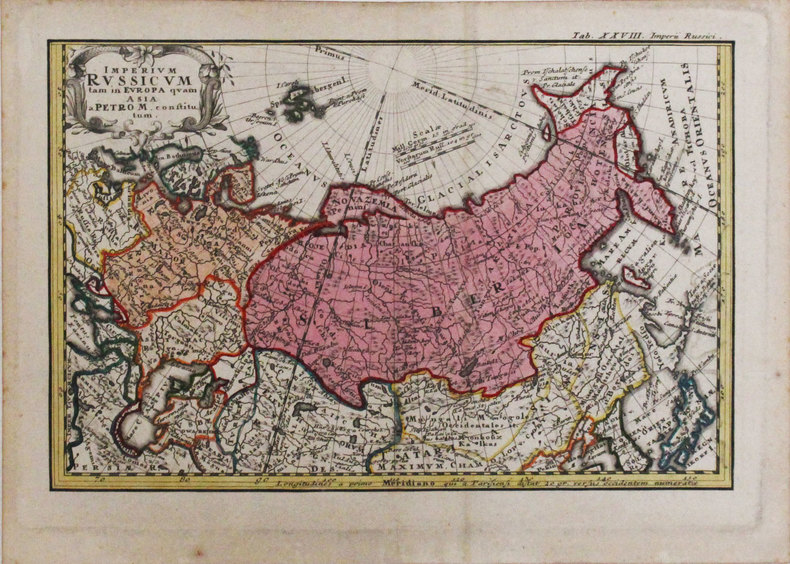
HASE (Johann Matthias).
Imperium Russicum tam in Europa quam Asia a Petro M constitutum.
1746. 166 x 253 mm.
Bookseller reference : LBW-3319
|
|
|
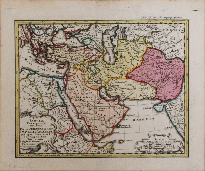
HASE (Johann Matthias).
Tabulae pars prima exhibens partes orientaliores Imperii Arabici.
1746. 168 x 212 mm.
Bookseller reference : LBW-3318
|
|
|
HASTREL (Adolphe d').
[BRÉSIL/RIO de JANEIRO] Marines et ports de mer. Rio-de-Janeiro. Baie Don Manuel. Cale de débarquement. Praia D. Manuel Cais Pharoux.
Paris, Goupil, Vibert et Cie, [circa 1850]. 295 x 216 mm.
Bookseller reference : LBW-4911

|
|
|
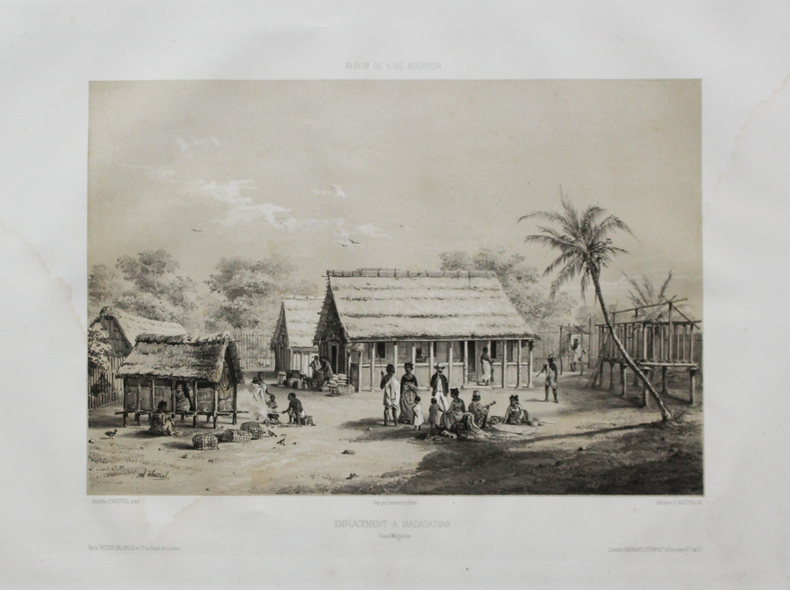
HASTREL (Adolphe d').
[MADAGASCAR] Album de l'Île Bourbon. Emplacement à Madagascar. Cases malgaches.
Paris, Victor Delarue et Ce, [circa 1850]. 245 x 303 mm.
Bookseller reference : LBW-4478
|
|
|
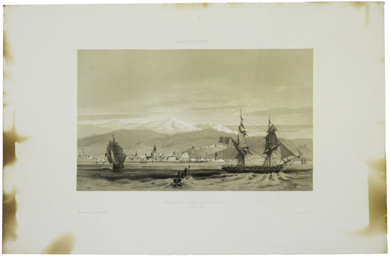
HASTREL (Adolphe d').
[MALAGA] Album d'Hastrel. Malaga (vue prise en grande rade). Espagne.
Paris,chez l'auteur, [circa 1850]. 220 x 301 mm.
Bookseller reference : LBW-4937
|
|
|
HASTREL (Adolphe d').
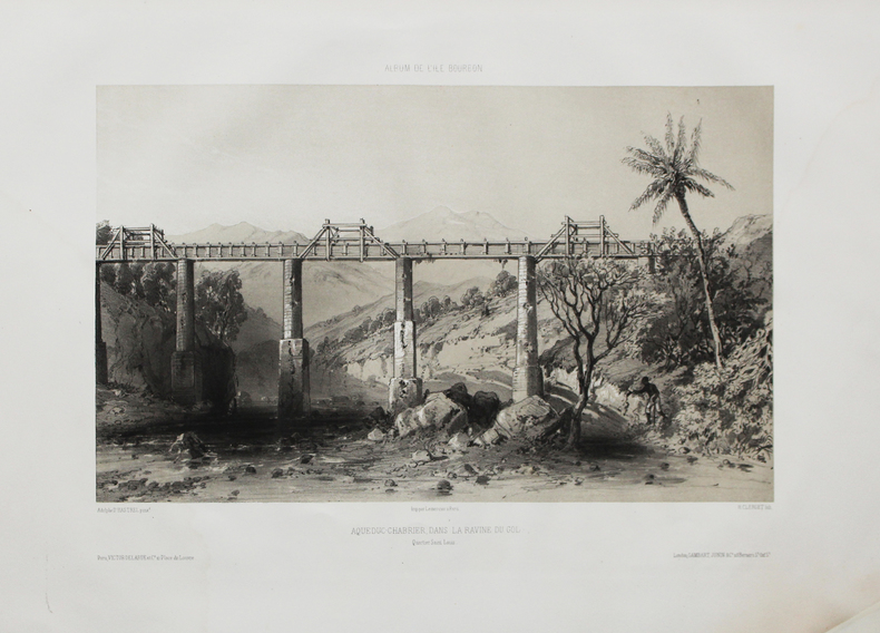
[RÉUNION] Album de l'Île Bourbon. Aqueduc-Chabrier, dans la ravine du Gol. Quartier Saint Louis.
Paris, Victor Delarue et Ce, [circa 1850]. 240 x 333 mm.
Bookseller reference : LBW-4470
|
|
|
HASTREL (Adolphe d').
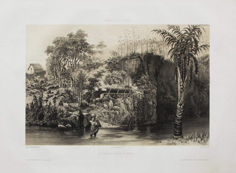
[RÉUNION] Album de l'Île Bourbon. La tonnelle de Parny au Bernica.
Paris, Victor Delarue et Ce, [circa 1850]. 245 x 320 mm.
Bookseller reference : LBW-4513
|
|
|
HASTREL (Adolphe d').
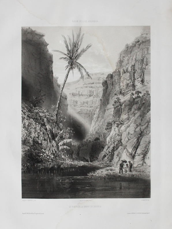
[RÉUNION] Album de l'Île Bourbon. Le bassin de la ravine du Bernica.
Paris, Victor Delarue et Ce, [circa 1850]. 345 x 231 mm.
Bookseller reference : LBW-4469
|
|
|
HASTREL (Adolphe d').
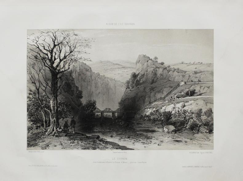
[RÉUNION] Album de l'Île Bourbon. Le Syphon. Canal traversant la rivière et ravine d'Abord - Quartier St Pierre.
Paris, Victor Delarue et Ce, [circa 1850]. 240 x 308 mm.
Bookseller reference : LBW-4494
|
|
|
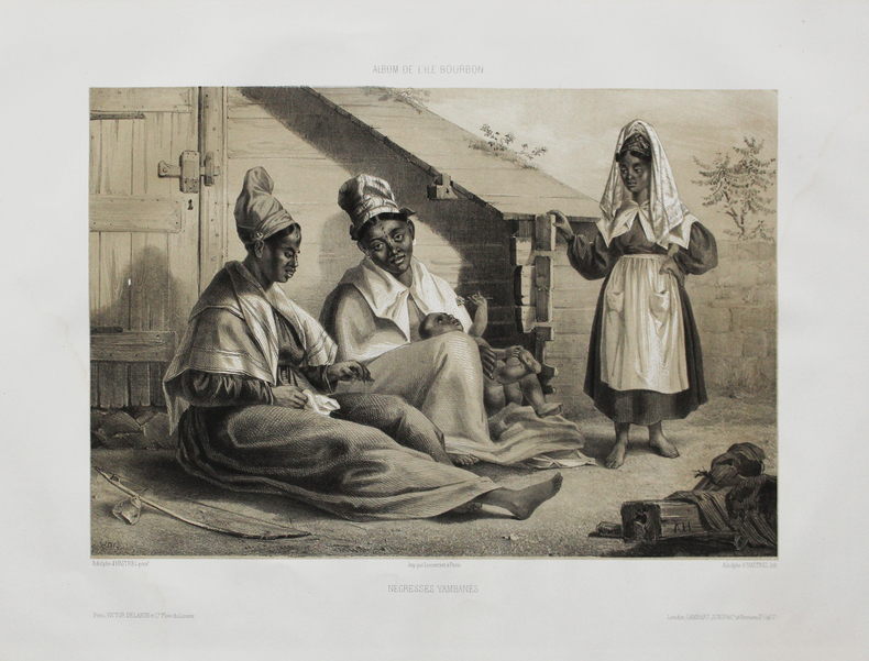
HASTREL (Adolphe d').
[RÉUNION] Album de l'Île Bourbon. Négresses yambanes.
Paris, Victor Delarue et Ce, [circa 1850]. 250 x 305 mm.
Bookseller reference : LBW-4501
|
|
|
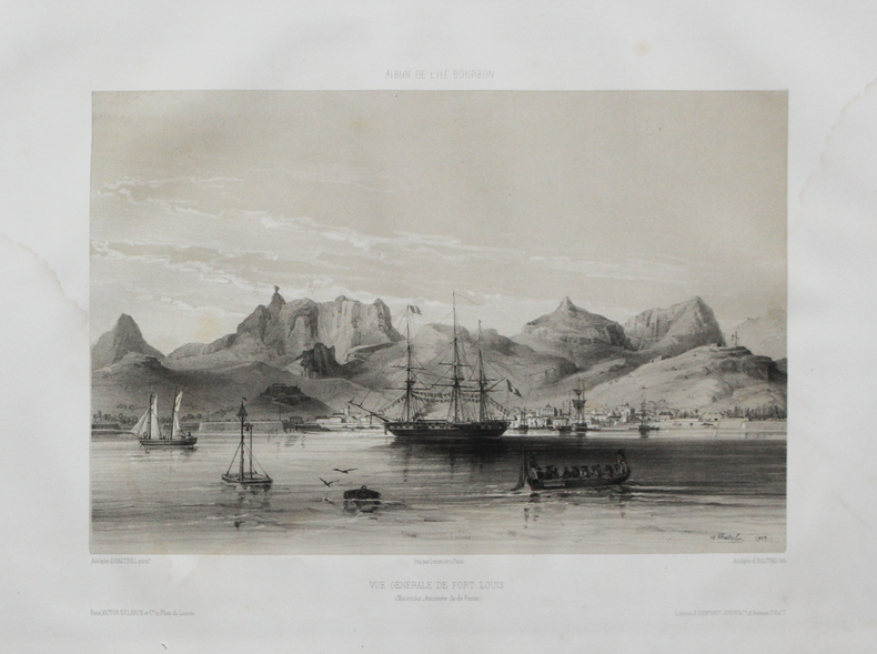
HASTREL (Adolphe d').
[ÎLE MAURICE] Album de l'Île Bourbon. Vue générale de Port Louis ( Mauritius - ancienne Île de France.
Paris, Victor Delarue et Ce, [circa 1850]. 245 x 310 mm.
Bookseller reference : LBW-4488
|
|
|
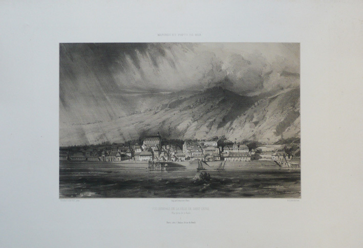
HASTREL (Adolphe d');
[REUNION] Marines et ports de mer. Vue générale de la ville de Saint-Denis (Vue prise de la rade).
Paris chez l'auteur circa 1850 252 x 320 mm.
Bookseller reference : LBW-1182
|
|
|
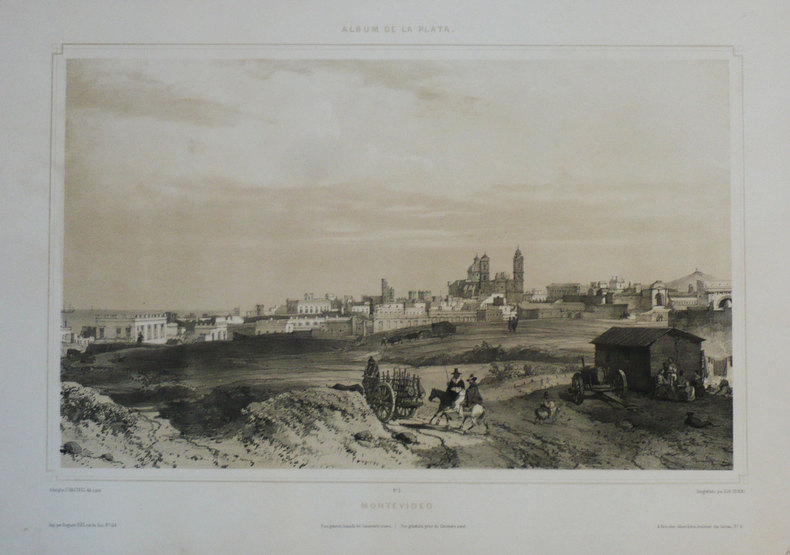
HASTREL (Adolphe d');
[URUGUAY] Montevideo. Vista general, tomada del cimenterio nuevo - Vue générale, prise du cimetière neuf.
Paris Gihaut frères 1846 305 x 423 mm.
Bookseller reference : LBW-1209
|
|
|
Hatter, Dr. James; Sayman, Al
Northwest Sportsman Magazine - Fishing, Hunting and Boating in B.C., August [Aug.] 1960 - Cover Photo of Einar Norman of Vancouver
34 pages. Features: Quick Reference 1960-61 Hunting Regulations and Game Management Maps; Mailbag; Dr. James Hatter and his Game Outlook; Nice one-page Old Vienna ad features large photo of hunter with deer and B.C. deer hunting statistics; One-page Crown Zellerbach ad with illustration of hunter says "Hunting Not Prohibited Here"; 2/3-page ad for the "Cariboo Dayliner" rail service offered by the Pacific Great Eastern Railway; One-page ad for Harkley & Haywood Sporting Goods Ltd. features fireamrs and accessories; Trout Fishing For Sport and a Delightful Recreation; Clay Chips - includes photos of Harvey Mackie, Colin Peacock, George Walker, R. Weatherhead, Rudy Wiley, Arnie Homewood, Henry Remple, Verne Greensword, Col. N.C. Sherman, Arnie Homewood, Aldon Hanson, Cy Bourne, Ken Bodwell, Tom Held, Russ Young and Jack Pratt; One-page ad by the Department of Recreation and Conservation gives tips for hunting on private lands; Back cover Pilsener beer ad; Many additional nostalgic ads. Unmarked with moderate wear. A quality vintage copy. Book

|
|
|
Hatter, Dr. James; Sismey, Eric
Northwest Sportsman Magazine - Fishing, Hunting and Boating in B.C., August [Aug.] 1961 - 1961-1962 Simplified Hunting Regulations and Game Management Maps
34 pages. Features: 1961-1962 Simplified Hunting Regulations and Game Management Maps; Dr. James Hunter explains changes to Game Regulations and predicts hunter success for the fall; Carcass Care - illustrated guide to processing a deer carcass; Clay Chips - article with photos of shooters Doug. Reynolds, Laurie Parkes, Alex Shymkowich, Dick Hornby, and Jim "Reliable" Mathieson; Many nostalgic ads; Two at the Same Time - article on Tyee fishing, with photo of Eric Sismey with Mrs. Elsie Ahlquist and two large Tyee; One-page ad by the Department of Recreation and Conservation entitled "Ready for the Field?" provides six tips - suitable for framing; Many additional nostalgic ads. Unmarked with moderate wear. A nice vintage copy. Book

|
|
|
HAUG Emile:
Traité de géologie. Les phénomènes géologiques. Les périodes géologiques.
Paris, Lib. Armand Colin, 1907. In-8 de [4]-536-[2] + [4]-1488 pages chiffrées 2024 p. Demi-maroquin noir, dos à nerfs ornés de fleurons dorés, tête jaspée. Très belle condition.
Bookseller reference : 2541

|
|
|
Haug Sarah:
There is no coming back !
Sarah Haug, 2016. 26 cartes postales détachables, à l'état de neuf, sous emballage d'origine comportant la vignette de titre.
Bookseller reference : 26571

|
|
|
HAULARD (Charles).
Nouveau plan de la ville de Rouen et de ses faubourgs.
Paris, Logerot s.d. (1856). Grand plan entoilé repliable ( 60cm x 81cm) en noir et blanc, en très bon état. Dans son étui de carton de papier marbré, , titre au dos.
Bookseller reference : 21053
|
|
|
Hauptvermessungsabt. XIII München
Wanderkarte: Wetterstein-Gebirge. Bearbeitet vom Bayer. Topographischen Bureau 1927.
München 1947. Maßstab: 1:50.000. Mehrfarb. Karte. 62 x 89 cm. Gefaltet. Faltmaß 16 x 12 cm.
Bookseller reference : 23719
|
|
|
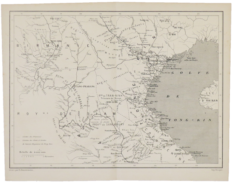
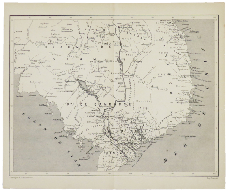
HAUSERMANN (Rémi).
[BIRMANIE/THAÏLANDE/INDOCHINE] [Sans titre].
[1880]. 211 x 280 mm.
Bookseller reference : LBW-5003
|
|
|
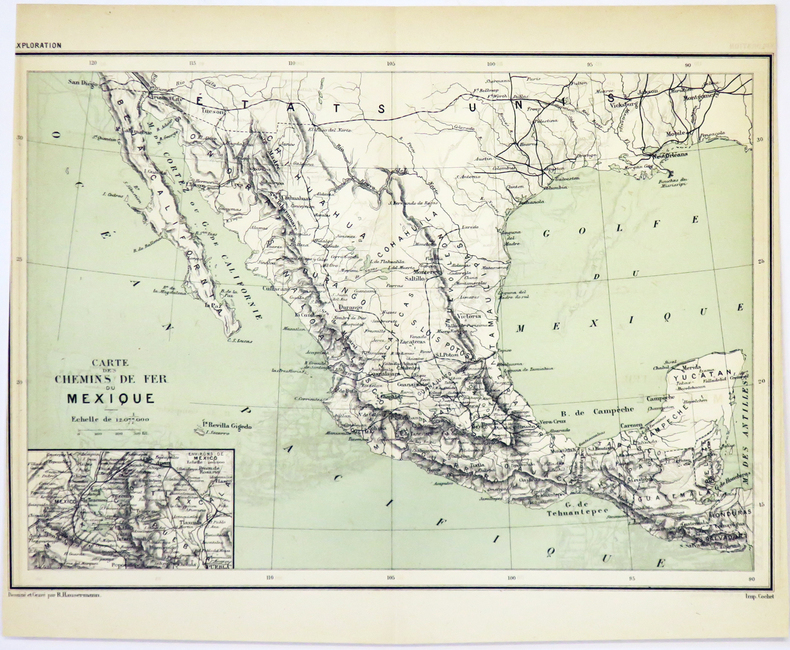
HAUSERMANN (Rémi).
[MEXIQUE/CHEMINS de FER] Carte des chemins de fer du Mexique.
[1881]. 204 x 290 mm.
Bookseller reference : LBW-5018
|
|
|
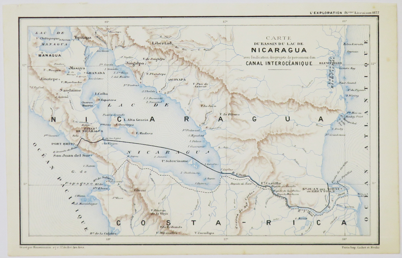
HAUSERMANN (Rémi).
[NICARAGUA] Carte du bassin du lac de Nicaragua avec l'indication des projets de percement d'un canal interocéanique.
[1877]. 140 x 220 mm.
Bookseller reference : LBW-5027
|
|
|
HAUSERMANN (Rémi).
[PATAGONIE] Carte de la Patagonie (Confédération argentine).
[1877]. 287 x 213 mm.
Bookseller reference : LBW-5020

|
|
|
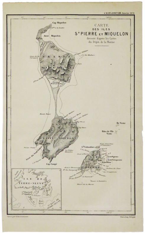
HAUSERMANN (Rémi).
[SAINT-PIERRE-et-MIQUELON] Carte des îles St Pierre et Miquelon.
[1879]. 210 x 135 mm.
Bookseller reference : LBW-5013
|
|
|
HAUSERMANN (Rémi).
[THAÏLANDE/INDOCHINE] [Sans titre].
[1880]. 207 x 274 mm.
Bookseller reference : LBW-5002
|
|
|
HAUTE GARONNE
Carte couleurs d?partementale au 1/200 000?me. Sans date.
Une feuille. 56x76 cm.
|
|
|
HAUTE-GARONNE
Carte couleurs d?partementale. Sans date.
Une feuille. 60x70 cm.
|
|
|
HAUTE-MARNE
Carte en couleurs du d?partement au 1/200 000e.
Une feuille 60x80 cm.
|
|
|
HAUTE-SAONE
Carte en couleurs du d?partement au 1/200 000e.
Une feuille 60x80 cm.
|
|
|
HAUTES PYRENEES
Carte d?partementale en couleurs . Sans date.
Une feuille 60x80cm repli?e sous couverture illustr?e.
|
|
|
HAUTES-PYRENEES
Carte d?partementale en couleurs des Hautes- Pyr?n?es au 1/200 000e. Sans date.
Une feuille 60x80 cm repli?e sous couverture. Cachets.
|
|
|
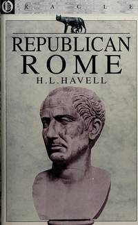
Havell, HL. (Herbert Lord); Maps and Battle Plans; Frontis [Illustrator] H. L.
Republican Rome
Oracle 1996-01-01. Paperback. New. In shrink wrap. Looks like an interesting title! Oracle paperback
Bookseller reference : Q-1861960050 ISBN : 1861960050 9781861960054
|
|
|
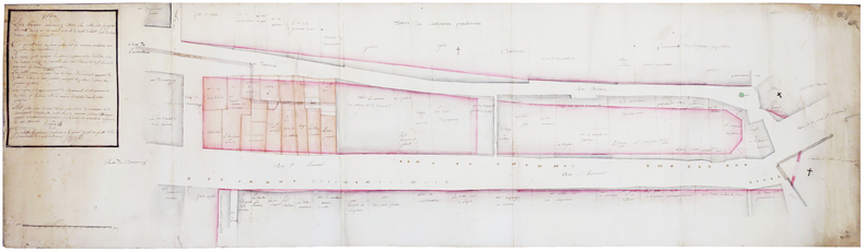
HAYERE.
Plan des tereins incendiez dans la ville de Fougères, la nuit du 29 au 30 aoust 1762, et du reste de l'islot entre les rues Derière et de St Léonard.
3 octobre 1762. 46,5 x 165 cm, sur trois feuilles jointes montées sur toile de lin.
Bookseller reference : LBW-6576
|
|
 Receive by email
 Download as PDF document
 RSS feed


