|
James, H. L. (Editor), Photographs/Pictures/Maps
Guidebook of the San Luis Basin Colorado: Twenty-Second Field Conference Sept. 30 - Oct. 1-2 1971
New Mexico Geological Society 1971. 325 pp. hardcover minor library markings else text clean & binding tight. INCLUDES maps in rear pocket. - If you are reading this this item is actually physically in our stock and ready for shipment once ordered. We are not bookjackers. Buyer is responsible for any additional duties taxes or fees required by recipient's country. New Mexico Geological Society hardcover
Bookseller reference : ZB1259760
|
|
|
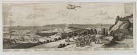
[TOKYO - ANTIQUE PRINT] VAN DER AA, PIERRE.
Iedo. Capitale du Japon.
A Leide. Leiden.: Chez Pierre van der Aa. circa1720. Engraved panorama on watermarked laid paper 28.5 x 77.5 including captions; 31 x 79.5 cm sheet title cartouche engraved key in French and Dutch the upper margin trimmed to the platemark original folds edgewear and toning neat sealed tear to the outer edge barely visible 5mm intrusion to the image a very good dark impression. Finely composed and engraved panorama of Tokyo prepared for the monumental work "Galerie Agreable du Monde" by the master Dutch publisher Pieter Van de Aa 1659-1733. The detailed key in Dutch and French notes myriad buildings and temples on the horizon and in the foreground two processions converge: of nobles and their attendants dancers a trio of dogs and a priest or religious attending a suppliant. <br> <br>Pieter van der Aa 1659-1733 was born in Leiden Holland and started his own book publishing business when he was only twenty-three. His prolific output of highly decorated maps and atlases culminated in his magnum opus “Galerie Agreable du Monde” which illustrated the world known to Europeans in the early eighteenth century. Comprising 66 volumes it was the of plates published at that time it has been estimated that only 100 copies were published. . Chez Pierre van der Aa unknown
Bookseller reference : 180201
|
|
|
Collins Maps
GB Road Atlas Britain 2021 Handy: A5 Spiral Collins Road Atlas
Paperback. Good. paperback
Bookseller reference : GOR012789756 ISBN : 0008374392 9780008374396
|
|
|
A-Z Maps
Great Britain A-Z Road Atlas 2023
Paperback. Very Good. paperback
Bookseller reference : GOR012604977 ISBN : 0008528721 9780008528720
|
|
|
Collins Maps
Collins First Atlas: Ideal for learning at school and at home Collins School Atlases
Paperback. Very Good. paperback
Bookseller reference : GOR012621296 ISBN : 0008485933 9780008485931
|
|
|
Philip's Maps
Philip's Yorkshire Dales: Leisure and Tourist Map Philip's Red Books
paperback. Good. Access codes and supplements are not guaranteed with used items. May be an ex-library book. paperback
Bookseller reference : 1849071535.G ISBN : 1849071535 9781849071536
|
|
|
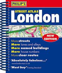
Philip's Maps
Philip's Street Atlas London - new spiral-bound edition: Mini Spiral Edition
Paperback. Acceptable. paperback
Bookseller reference : GOR012509949 ISBN : 1849074534 9781849074537
|
|
|
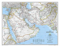
National Geographic Maps
National Geographic: Middle East Classic Wall Map 30.25 X 23.5 Inches
National Geographic Maps / NLGM. POSTER. 2018. 9780792281146 :Subject:Travel Maps & Road Atlases see also Reference Atlases Gazetteers & Maps . NEW. National Geographic Maps / NLGM unknown
Bookseller reference : 0792281144 ISBN : 0792281144 9780792281146
|
|
|
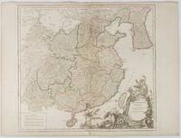
VAUGONDY, ROBERT DE.
L'Empire de La Chine dressé d'après les cartes de l'Atlas Chinois
Paris. 1751. Engraved map 48 x 52.2 cm; 51 x 67.6 cm sheet provinces highlighted with outline hand-colour elaborate title cartouche central fold small tear at the foot affecting the border old paper repair on the verso affecting the margin only pin-holes to the four marginal corners margins a little browned and dusty a handsome map in good condition. Fine large format map showing China Korea Taiwan and parts of Central Asia prepared for De Vaugondy's "Atlas Universel". The beautifully foliated cartouche features a duo of joyful Chinese musicians one dancing and a diminutive figure holding a parasol. <br> <br>From the Estate of the late collector and scholar Arthur Hacker. . unknown
Bookseller reference : 177606
|
|
|
Cycle Maps UK
Edinburgh and Central Southern Scotland Cycle Map 24 Cycle Maps UK
Cycle Maps UK 2022. Map. New. 2 pages. 6.34x3.98x0.51 inches. Cycle Maps UK unknown
Bookseller reference : __1904207723 ISBN : 1904207723 9781904207726
|
|
|
Cycle Maps UK
Peak District Cycle Map 18 Cycle Maps UK
Cycle Maps UK 2022. Map. New. 2 pages. 6.42x3.94x0.63 inches. Cycle Maps UK unknown
Bookseller reference : __1904207731 ISBN : 1904207731 9781904207733
|
|
|
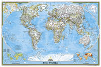
National Geographic Maps
National Geographic: World Classic Wall Map Poster Size: 36 X 24 Inches
National Geographic Maps / NLGM. POSTER. 2018. 9781597752138 :Subject:Reference Atlases Gazetteers & Maps see also Travel Maps & Road Atlases . NEW. National Geographic Maps / NLGM unknown
Bookseller reference : 1597752134 ISBN : 1597752134 9781597752138
|
|
|
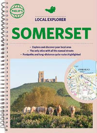
Philip's Maps
Philip's Local Explorer Street Atlas Somerset: Spiral binding
Spiral bound. New. unknown
Bookseller reference : A9781849076036 ISBN : 1849076030 9781849076036
|
|
|
Heron Maps
Forth and Clyde and Union Canals
Paperback / softback. New. paperback
Bookseller reference : A9781908851246 ISBN : 1908851244 9781908851246

|
|
|
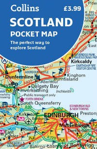
Collins Maps
Scotland Pocket Map: The perfect way to explore Scotland
Sheet map folded. New. Handy little full colour map of Scotland. Excellent value and very detailed for its size. Double-sided folded map with the Central Belt southern Scotland and northern England on one side and northern Scotland including Orkney and Shetland on the reverse. unknown
Bookseller reference : A9780008492571 ISBN : 0008492573 9780008492571
|
|
|
Kate Cartes
Potty Training: A Step-By-Step Guide to Use Potty and Make Your Toddler Free from Dirty Diapers. Includes Tips and Techniques for Stress-Free Results
Paperback / softback. New. paperback
Bookseller reference : B9781802238945 ISBN : 1802238948 9781802238945

|
|
|
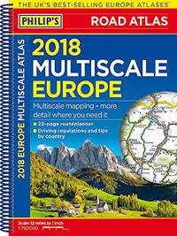
Philip's Maps
Philip's 2018 Multiscale Road Atlas Europe: A4 Spiral binding Philips Road Atlas
Paperback. Acceptable. paperback
Bookseller reference : GOR012343848 ISBN : 1849074216 9781849074216
|
|
|
Thomas Bros. Maps
Thomas Guide 2000 Los Angles County: Street Guide and Directory
Thomas Brothers Maps 1999-08-01. Spiral-bound. Very Good. 0.9000 11.2000 8.3000. Thomas Brothers Maps unknown
Bookseller reference : mon0002916645 ISBN : 1581741227 9781581741223

|
|
|
Common English Bible; National Geographic Maps [Illustrator]
CEB Common English Bible New Testament Softcover
Common English Bible 2010-10-01. Paperback. New. 84x16x132. Common English Bible paperback
Bookseller reference : 1609260066-11-25160307 ISBN : 1609260066 9781609260064

|
|
|
Collins Maps
Scotland Pocket Map: The Perfect Way To Explore Scotland
Harpercollins Publishers 2022. Sheet Map Folded. New. 2 pages. 5.51x3.54x0.24 inches. Harpercollins Publishers unknown
Bookseller reference : __0008492573 ISBN : 0008492573 9780008492571
|
|
|
Weir, Simon A-Z Maps
-Z Britain For Bikers: 100 Scenic Routes Around The Uk
Harpercollins Publishers 2022. Spiral Bound. New. 224 pages. 8.39x6.54x0.87 inches. Harpercollins Publishers unknown
Bookseller reference : __0008496293 ISBN : 0008496293 9780008496296

|
|
|
Sharp, Alan A-Z Maps
-Z Edinburgh Hidden Walks: Discover 20 Routes In And Around The City
Harpercollins Publishers 2022. Paperback / Softback. New. 128 pages. 7.05x4.96x0.55 inches. Harpercollins Publishers paperback
Bookseller reference : __0008496315 ISBN : 0008496315 9780008496319

|
|
|
Thomas Brothers Maps
Los Angeles Orange Counties 1993
Thomas Brothers Maps 1992-10-01. Unbound. Good. . Thomas Brothers Maps unknown
Bookseller reference : mon0002892119 ISBN : 0881305839 9780881305838
|
|
|
Outdoor Books & Maps
Colorado 4-Wheel Drive Roads
Outdoor Books and Maps 2007. Paperback. Acceptable. Readable copy. Pages may have considerable notes/highlighting. ~ ThriftBooks: Read More Spend Less.Dust jacket quality is not guaranteed. Outdoor Books and Maps paperback
Bookseller reference : G0930657403I5N00 ISBN : 0930657403 9780930657406

|
|
|
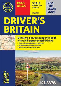
Philip's Maps and Atlases
Philip's Driver's Atlas Britain: A4 Paperback
Paperback / softback. New. Perfect for new drivers and the more experienced motorist this great value Driver's Road Atlas has been fully updated with Britain's clearest and most detailed mapping from Philip's. paperback
Bookseller reference : A9781849075688 ISBN : 1849075689 9781849075688
|
|
|
A-Z maps
A-Z Secret York Walks
Paperback / softback. New. paperback
Bookseller reference : A9780008496333 ISBN : 0008496331 9780008496333

|
|
|
A-Z maps
A-Z Secret Oxford Walks
Paperback / softback. New. paperback
Bookseller reference : A9780008496326 ISBN : 0008496323 9780008496326

|
|
|
Collins Maps
Devon Pocket Map: The Perfect Way To Explore Devon
Harpercollins Publishers 2022. Sheet Map Folded. New. 1 pages. 5.51x3.54x0.20 inches. Harpercollins Publishers unknown
Bookseller reference : __0008520674 ISBN : 0008520674 9780008520670
|
|
|
Collins Maps
Dorset Pocket Map: The Perfect Way To Explore Dorset
Harpercollins Publishers 2022. Sheet Map Folded. New. 1 pages. 5.51x3.54x0.20 inches. Harpercollins Publishers unknown
Bookseller reference : __0008520682 ISBN : 0008520682 9780008520687
|
|
|
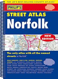
Philip's Maps
Philip's Street Atlas Norfolk: Spiral Edition
Paperback. Like New. paperback
Bookseller reference : GOR012160197 ISBN : 1849074283 9781849074285
|
|
|
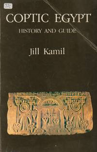
Kamil, Jill; Ibrahim, Hassan (plans & maps)
Coptic Egypt _ History and Guide
Cairo: American University in Cairo Press 1988. Paperback Octavo. Paperback. Good. wraps 149 pp crease to front cover remains of sticker to front cover<br /> <br /> Standard shipping no tracking / Priority with tracking / Custom quote for large or heavy orders. American University in Cairo Press paperback
Bookseller reference : 76587 ISBN : 9774241045 9789774241048
|
|
|
Philip's Maps
Philip's The Cotswolds: Leisure and Tourist Map Philip's Red Books
Philip's 2020-02-06. paperback. Used: Good. 5.04x0.31x8.82. Buy with confidence. Excellent Customer Service & Return policy. Philip's paperback
Bookseller reference : SONG1849075387 ISBN : 1849075387 9781849075381
|
|
|
Philip's Maps
Philip's Britain and Ireland Road Map Philip's Sheet Maps
Philip's 2020-10-01. paperback. Used: Good. 1.65x0.31x4.49. Buy with confidence. Excellent Customer Service & Return policy. Philip's paperback
Bookseller reference : SONG1849075425 ISBN : 1849075425 9781849075428
|
|
|
Philip's Maps
Philip's RGS World Atlas: 10th Edition paperback Philip's World Atlas
Philip's 2021-04-22. paperback. Used: Good. 9.06x0.87x12.20. Buy with confidence. Excellent Customer Service & Return policy. Philip's paperback
Bookseller reference : SONG1849075581 ISBN : 1849075581 9781849075589
|
|
|
Deighton, Len; Bishop, Denis (maps & drawings)
Blood Tears and Folly _ An Objective Look at World War II
New Jersey: Castle Books 1999. Cloth/dust jacket Octavo. Hardcover. Very good/very good. black leather spine gilt lettering maroon papered boards dust jacket 653 pp maps & ills to paste downs and end papers<br /> <br /> Standard shipping no tracking / Priority with tracking / Custom quote for large or heavy orders. Castle Books hardcover
Bookseller reference : 76755 ISBN : 0785811141 9780785811145

|
|
|
Goebel, Michael/ 3 Maps (Corporate Author)/ Print
Overlapping Geographies of Belonging: Migrations Regions and Nations in the Western South Atlantic
Amer Historical Assn 2013. Paperback. New. 60 pages. 5.30x8.20x0.40 inches. Amer Historical Assn paperback
Bookseller reference : x-0872292053 ISBN : 0872292053 9780872292055

|
|
|
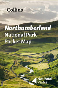
National Parks Uk Collins Maps
Northumberland National Park Pocket Map: The Perfect Guide To Explore This Area Of Outstanding Natural Beauty
Harpercollins Publishers 2022. Sheet Map Folded. New. 1 pages. 5.43x3.58x0.35 inches. Harpercollins Publishers unknown
Bookseller reference : __0008462704 ISBN : 0008462704 9780008462703
|
|
|
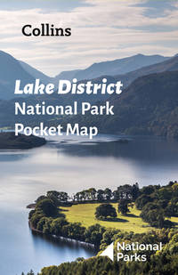
National Parks Uk Collins Maps
Lake District National Park Pocket Map: The Perfect Guide To Explore This Area Of Outstanding Natural Beauty
Harpercollins Publishers 2022. Sheet Map Folded. New. 1 pages. 5.51x3.54x0.75 inches. Harpercollins Publishers unknown
Bookseller reference : __0008462674 ISBN : 0008462674 9780008462673
|
|
|
Collins Maps
Collins First Atlas
Collins 2015-05-01. Second Edition Second edition. paperback. Used: Good. 0.50x5.00x6.90. Buy with confidence. Excellent Customer Service & Return policy. Collins paperback
Bookseller reference : SONG0008101019 ISBN : 0008101019 9780008101015

|
|
|
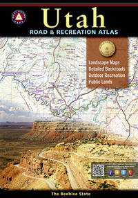
Benchmark Maps
Utah Road & Recreation Atlas Benchmark Maps
Benchmark 2017-05-01. Seventh Edition 2017. paperback. Used: Good. 10.50x0.50x15.25. Buy with confidence. Excellent Customer Service & Return policy. Benchmark paperback
Bookseller reference : SONG0929591356 ISBN : 0929591356 9780929591353
|
|
|
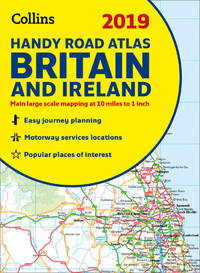
Collins Maps
2019 Collins Handy Road Atlas Britain and Ireland
Collins 2018-10-01. spiral_bound. Used: Good. 0.00x6.00x8.25. Buy with confidence. Excellent Customer Service & Return policy. Collins unknown
Bookseller reference : SONG0008276404 ISBN : 0008276404 9780008276409
|
|
|
Heron Maps
River Thames and the Thames Path Waterways Series
Heron Maps 2021-04-12. 3rd. paperback. New. 8.74x0.47x5.55. Buy with confidence. Excellent Customer Service & Return policy. Heron Maps paperback
Bookseller reference : DADAX1908851325 ISBN : 1908851325 9781908851321
|
|
|
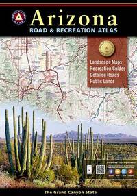
National Geographic Maps
Arizona Benchmark Road & Recreation Atlas
Benchmark 2015-01-01. 2015. paperback. Used: Good. 10.50x0.25x15.00. Buy with confidence. Excellent Customer Service & Return policy. Benchmark paperback
Bookseller reference : SONG0929591909 ISBN : 0929591909 9780929591902
|
|
|
Collins Maps
Collins Primary Atlas Collins Primary Atlases
Collins 2016-06-01. Fifth Edition Fifth edition. paperback. New. 8.75x0.20x12.25. Buy with confidence. Excellent Customer Service & Return policy. Collins paperback
Bookseller reference : DADAX0008146756 ISBN : 0008146756 9780008146757

|
|
|
Collins Maps
Collins Handy Street Map London
Collins 2019-09-01. New edition. map. Used: Good. 4.50x0.30x7.50. Buy with confidence. Excellent Customer Service & Return policy. Collins unknown
Bookseller reference : SONG0008320586 ISBN : 0008320586 9780008320584

|
|
|
Collins Maps
Collins Primary Atlas Collins Primary Atlases
Collins 2016-06-01. Fifth Edition Fifth edition. paperback. Used: Good. 8.75x0.20x12.25. Buy with confidence. Excellent Customer Service & Return policy. Collins paperback
Bookseller reference : SONG0008146756 ISBN : 0008146756 9780008146757
|
|
|
Collins Maps
Collins Ireland Comprehensive Road Atlas
Collins 2015-05-01. New edition. spiral_bound. Used: Good. 8.50x0.30x12.00. Buy with confidence. Excellent Customer Service & Return policy. Collins unknown
Bookseller reference : SONG0008102287 ISBN : 0008102287 9780008102289

|
|
|
Philip's Maps
Philip's Street Atlas Derbyshire
Paperback. Acceptable. paperback
Bookseller reference : GOR012036162 ISBN : 1849074291 9781849074292

|
|
|
[MAPS - IRAQ].
Reconnaissance maps of Iraq.UK Government Survey Directorate HQ Tenth Army / Indian Field Survey Co. 1942 42 chromolithographed topographic maps of parts of Iraq made from aerial photographs during World War II on a scale of 1:100000 and 1:253440 a quarter-inch to a mile. 68 x 50.5 cm & 60 x 47 cm.
An impressive collection of Iraq maps compiled from the most current aerial photography and produced by the British Army for use in the Persian theatre of war during World War II. The cities and regions covered include ‘Ain Sifni Aqra Tel Afar Salman Pak Ba’Quba Sumaika Penjwin Halabja Baghdad Kirkuk Dulaim Erbil and Mosul divisions.Previously folded. Generally well-preserved. unknown
Bookseller reference : L7VCIV4N38L2
|
|
|
000 1"=47 miles. Metro Maps 1:158:000 1"=25 miles11th Edition 2021. ISBN 978-1-7343150-3-5"
California Road and Recreation Atlas - 11th Edition 2021
11th Edition 2021 0000-00-00. Benchmark Maps. paperback. Used: Good. 10.51x0.71x15.12. Buy with confidence. Excellent Customer Service & Return policy. 11th Edition, 2021 paperback
Bookseller reference : SONG1734315032 ISBN : 1734315032 9781734315035
|
|
 Receive by email
 Download as PDF document
 RSS feed


