|
National Geographic Maps
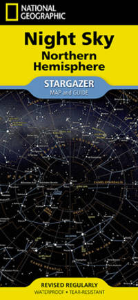
National Geographic Night Sky - Northern Hemisphere Map Stargazer Folded
National Geographic Maps / NLGM. POSTER. 2024. 9781566959506 :- Waterproof - Tear-Resistant - Stargazer Map and Guide - Subject: Reference Atlases Gazetteers & Maps see also Travel Maps & Road At Astronomy . NEW. National Geographic Maps / NLGM unknown
Bookseller reference : 1566959500 ISBN : 1566959500 9781566959506
|
|
|
National Geographic Maps
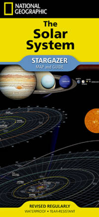
National Geographic Solar System Map Stargazer Folded
National Geographic Maps / NLGM. POSTER. 2024. 9781566959520 :- Waterproof - Tear-Resistant - Stargazer Map and Guide -- Subject: Reference Atlases Gazetteers & Maps Astronomy . NEW. National Geographic Maps / NLGM unknown
Bookseller reference : 1566959527 ISBN : 1566959527 9781566959520
|
|
|
A-Z Maps
Leeds A-Z Pocket Street Map
Harpercollins Publishers 2024. Sheet Map Folded. New. 2nd revised edition edition. 2 pages. 3.54x0.12x5.51 inches. Harpercollins Publishers unknown
Bookseller reference : __0008657424 ISBN : 0008657424 9780008657420

|
|
|
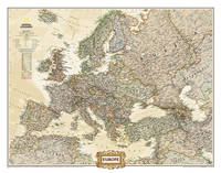
National Geographic Maps
National Geographic Europe Wall Map - Executive 30.5 X 23.75 In
National Geographic Maps / NLGM. POSTER. 2019. 9780792289838 :Binding: Not Folded<br />Subject: Travel Maps & Road Atlases see also Reference Atlases Gazetteer . NEW. National Geographic Maps / NLGM unknown
Bookseller reference : 0792289838 ISBN : 0792289838 9780792289838
|
|
|
Global, MAPS
MAPS Foundations Second Edition
Independently published 2019. Paperback. New. 171 pages. 11.00x8.50x0.39 inches. Independently published paperback
Bookseller reference : 1-1697158250 ISBN : 1697158250 9781697158250
|
|
|
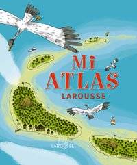
Didier Sandman. Mapas: Dominique Botbol
GUIDES DELTA FLAMMARION: India del Sur. Versión castellana
GRECH 1987. Encuadernación de tapa blanda. Bien. Ediciones Grech S.A. 1987. Tapa blanda de editorial ilustrada. Buen estado de conservación. ISBN: 8475970346. Viajes. Turismo. GuÃas turÃsticas. India meridional. Andamán. Nicobar. GRECH unknown
Bookseller reference : 12816 ISBN : 8475970346 9788475970349

|
|
|
Delalandre, Benoit; Jeremy ClapIn (Ilustr.); Pronto (Mapas)
Mi Atlas Larousse Incluye poster con mapamundi Castellano - A Partir De 6 Años
Larousse Editorial 2010. Tapa Dura. Bien. Infantil y juvenil. Profusamente ilustrado con dibujos color. 28 x 25. GEOGRAFIA. HISTORIA. DIVULGACION. Tapa dura de editorial ilustrada. Sin subrayados ni anotaciones. Buen estado de conservación. Este atlas presentado en un formato muy adecuado para niños contiene gran cantidad de mapas e imágenes para viajar por todo el mundo. Sus ilustraciones poseen un toque de humor que las hace muy divertidas para los pequeños y llama la atención de los mayores. El atlas está organizado por continentes y cada uno de ellos contiene un mapa fÃsico con informaciones de nuestro entorno un mapa polÃtico desplegable con sus respectivos paÃses y grandes imágenes para conocer la vida de los pueblos del mundo. El libro ofrece un póster gigante con un mapamundi en el que los más pequeños podrán localizar la cumbre más alta del mundo el desierto más grande el árbol más viejo la región donde menos llueve el viento más fuerte. entre otros numerosos y curiosos datos. La obra se completa con un Ãndice terminológico final para facilitar las búsquedas. Este libro recomendado a partir de los 6 años incluye mapas e imágenes para viajar por todo el mundo. Encontraremos para cada continente:- Un mapa fÃsico con informaciones de nuestro entorno.- Grandes imágenes para conocer la vida de los pueblos del mundo.- Un mapa polÃtico desplegable de cada continente con sus paÃses.Contiene un póster con un gran mapamundi.nnn Larousse Editorial hardcover
Bookseller reference : 114226 ISBN : 8483327651 9788483327654
|
|
|
Philips Maps
2023 Philips Easy to Read Multiscale Road Atlas Europe: A4 Spiral binding Philips Road Atlases
Philips 04/07/2022. Spiral_bound. Used; Good. WE SHIP WITHIN 24 HRS FROM LONDON UK 98% OF OUR ORDERS ARE RECEIVED WITHIN 7-10 DAYS. We believe you will be completely satisfied with our quick and reliable service. All orders are dispatched as swiftly as possible! Buy with confidence! Greener Books. Philips unknown
Bookseller reference : 4566005 ISBN : 1849075549 9781849075541

|
|
|
Collins Maps
Scotland Touring Map: Ideal for exploring
Paperback. Acceptable. paperback
Bookseller reference : GOR013767752 ISBN : 0008368309 9780008368302

|
|
|
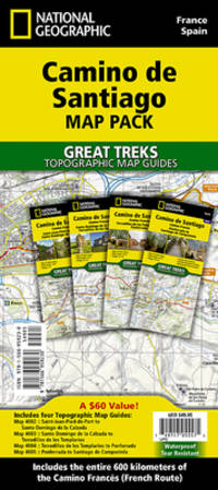
National Geographic Maps (Author)
Camino de Santiago - Camino Frances Map Pack Bundle - 4 map pack for the whole route National Geographic Great Treks
National Geographic Maps 2024. Paperback. New. 2024 fol m edition. 192 pages. 9.38x4.25x0.59 inches. National Geographic Maps paperback
Bookseller reference : __1566959233 ISBN : 1566959233 9781566959230
|
|
|
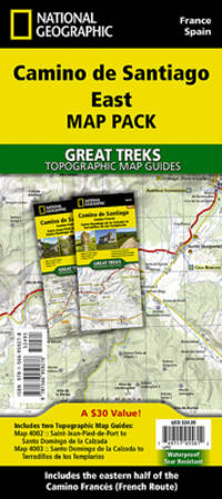
National Geographic Maps (Author)
Camino de Santiago - Camino Frances East Map Pack Bundle 2 map set National Geographic Great Treks
National Geographic Maps 2024. Paperback. New. 2024 fol m edition. 96 pages. 9.38x4.25x0.39 inches. National Geographic Maps paperback
Bookseller reference : __1566959276 ISBN : 1566959276 9781566959278
|
|
|
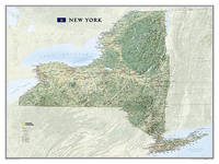
National Geographic Maps
New York State Wall Map - Laminated
Natl Geographic Society Maps 2009. Map. New. lam map edition. 1 pages. 30.40x2.00x2.00 inches. Natl Geographic Society Maps unknown
Bookseller reference : 1-159775238X ISBN : 159775238X 9781597752381
|
|
|
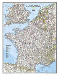
National Geographic Maps
National Geographic France Belgium and The Netherlands Wall Map - Classic - Laminated 23.5 x 30.25 in National Geographic Reference Map
Natl Geographic Society Maps 2014-11-12. 2016. map. Used: Good. 3.00x3.00x43.50. Buy with confidence. Excellent Customer Service & Return policy. Natl Geographic Society Maps unknown
Bookseller reference : SONG0792292618 ISBN : 0792292618 9780792292616
|
|
|
MAD Maps
Get Outta Town: Miami Laminated Map
MAD Maps 2007. Map. New. 2007 edition. 1 pages. 3.90x3.80x0.50 inches. MAD Maps unknown
Bookseller reference : 1-1933911298 ISBN : 1933911298 9781933911298

|
|
|
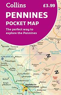
Collins Maps
Pennines Pocket Map: The perfect way to explore the Pennines
Paperback. Very Good. paperback
Bookseller reference : GOR013696135 ISBN : 0008520704 9780008520700
|
|
|
PopOut Maps
York PopOut Map: Pocket size pop up city map of York
Sheet map folded. New. Let PopOut Map York guide you around the historic walled city of York. This handy pocket-sized York pop up map features a detailed street map of York as well as advice on the top things to see while you're there. Ideal York city map that you can easily pop in a pocket or bag for quick reference while exploring. unknown
Bookseller reference : A9781914515873 ISBN : 1914515870 9781914515873

|
|
|
PopOut Maps
Marrakesh PopOut Map - pocket size pop up city map of Marrakesh
Sheet map folded. New. Uncover the exotic charms of Marrakesh with this handy pop-up map. This genuinely pocket-sized Marrakesh city map includes 2 PopOut maps featuring a street map of central Marrakesh an overview map of greater Marrakesh with additional maps showing the Souks Gueliz and around Marrakesh. Ideal to pop in a pocket or bag for quick reference. unknown
Bookseller reference : A9781914515750 ISBN : 1914515757 9781914515750

|
|
|
Andrist, Ralph K.; Palacios, Raphael D. (Maps)
The Long Death; The Last Days of the Plains Indian
New York; London: The Macmillan Company; Collier - Macmillan Limited NONE NONE 1964. hardcover ix 371pp. Very good. 8vo. A documented history of the military conquests as related to the Plains Indians. Maps black and white historical photographs. Brown-red cloth title stamped in gilt to spine. Moderate wear and marking to the cover and there is a name penned small neat to the front free endpaper. Iinternally clean and bright. Solid copy. The Macmillan Company; Collier - Macmillan Limited NONE Hardcover
Bookseller reference : 131012
|
|
|
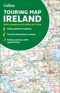
Collins Maps
Collins Ireland Touring Map
Sheet map folded. New. New Book; Fast Shipping from UK; Not signed; Not First Edition; Explore new places with handy pocket maps from Collins. Large full colour map of the whole of Ireland showing the road network in detail and with a special emphasis on places of tourist interest. unknown
Bookseller reference : ria9780008369965_inp ISBN : 0008369968 9780008369965
|
|
|
Collins Maps
Peak District National Park Pocket Map
Sheet map folded. New. New Book; Fast Shipping from UK; Not signed; Not First Edition; Handy little full-colour map and guide of Peak District National Park. Detailed mapping and visitor information to the National Park along with a selection of photographs. Map at a scale of 1:120 000 1cm to 1.20km 1.9 miles unknown
Bookseller reference : ria9780008439217_inp ISBN : 0008439214 9780008439217

|
|
|
A-Z Maps
Nottingham A-Z Pocket Street Map
Sheet map folded. New. New Book; Fast Shipping from UK; Not signed; Not First Edition; Navigate your way around Nottingham with detailed street maps from A-Z unknown
Bookseller reference : ria9780008445331_inp ISBN : 0008445338 9780008445331

|
|
|
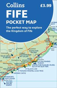
Collins Maps
Fife Pocket Map
Sheet map folded. New. New Book; Fast Shipping from UK; Not signed; Not First Edition; Explore new places with handy pocket maps from Collins. Handy little full colour map of the coastal Kingdom of Fife. Detailed mapping and tourist information from Dundee in the North to Edinburgh in the south and from Fife c unknown
Bookseller reference : ria9780008467449_inp ISBN : 0008467447 9780008467449
|
|
|
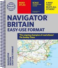
Philip's Maps
Philip's Navigator Britain Easy Use Format
Spiral bound. New. New Book; Fast Shipping from UK; Not signed; Not First Edition; With updated super-clear super-detailed mapping and in a great lie-flat format the Philip's Navigator Britain Easy-Use Format ensures the Navigator remains unrivalled amongst British road atlases. unknown
Bookseller reference : ria9781849075695_inp ISBN : 1849075697 9781849075695
|
|
|
Philip's Maps
Philip's The Cotswolds
Sheet map. New. New Book; Fast Shipping from UK; Not signed; Not First Edition; A new edition of this double-sided map of the Cotswolds. Featuring places of tourist and historic interest in an easy-to-read style of mapping and with six town centre plans. unknown
Bookseller reference : ria9781849075381_inp ISBN : 1849075387 9781849075381

|
|
|
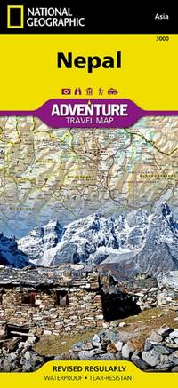
National Geographic Maps
Nepal
Sheet map folded. New. New Book; Fast Shipping from UK; Not signed; Not First Edition; unknown
Bookseller reference : ria9781566956536_inp ISBN : 1566956536 9781566956536
|
|
|
Collins Maps
Clans and Tartans Map of Scotland Pictorial Map
map. Good. Access codes and supplements are not guaranteed with used items. May be an ex-library book. unknown
Bookseller reference : 0007184611.G ISBN : 0007184611 9780007184613

|
|
|
Old House Books & Maps
The 10.30 Limited: A Railway Book for Boys of All Ages
hardcover. Good. Access codes and supplements are not guaranteed with used items. May be an ex-library book. hardcover
Bookseller reference : 1908402172.G ISBN : 1908402172 9781908402172

|
|
|
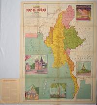
[BURMA - MAP]
Latest Map of Burma : political showing relief of land.
Delhi.: S.B. Makhija & Brothers. circa1951. Printed colour map 98.6 x 69 cms folding into pictorial wrappers 25.3 x 19.5 cms five pictorial colour inserts of pagodas and the Shwethalyaung reclining Buddha wrappers a little chipped marginal wear and three small fold splits in the map but overall in very good condition. Attractive large map of Burma with the provinces coloured steamship routes shown in red and printed in the booklet a range of information printed based on the 1951 census including climate agriculture and form of government "Burma became an independent nation completely outside the British Empire on January 4 1948 and is now a sovereign independent republic known as the Union of Burma". . S.B. Makhija & Brothers. unknown
Bookseller reference : 214601
|
|
|
Collins Maps
2020 Collins Essential Road Atlas Britain and Northern Ireland
Collins 9/1/2019 12:00:01 AM. spiral_bound. Very Good. 0.9449 in x 11.6929 in x 8.7008 in. Collins unknown
Bookseller reference : mon0001223061 ISBN : 0008318700 9780008318703

|
|
|
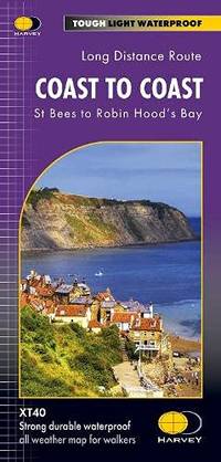
Harvey Maps Services ltd
Coast to Coast Trail Maps XT40: St Bees to Robin Hood's Bay
Paperback. Very Good. paperback
Bookseller reference : GOR013378706 ISBN : 1851376186 9781851376186
|
|
|
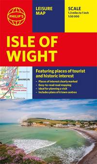
Philip's Maps
Philip's Isle of Wight Leisure & Tourist Map: Leisure and Tourist Map Philip's Red Books
Paperback. Good. paperback
Bookseller reference : GOR013231306 ISBN : 1849076111 9781849076111
|
|
|
Maps, PopOut
Madrid PopOut Map
map. Good. Access codes and supplements are not guaranteed with used items. May be an ex-library book. unknown
Bookseller reference : 1845879961.G ISBN : 1845879961 9781845879969

|
|
|
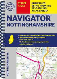
Philip's Maps
Philip's Navigator Street Atlas Nottinghamshire
Spiral bound. New. The only county Street Atlas with all the named streets of Nottinghamshire and perfect back-up for emergency services delivery drivers visitors and locals. unknown
Bookseller reference : A9781849076418 ISBN : 1849076413 9781849076418
|
|
|
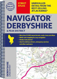
Philip's Maps
Philip's Navigator Street Atlas Derbyshire and the Peak District
Spiral bound. New. The only county Street Atlas with all the named streets of Derbyshire and the Peak District and perfect back-up for emergency services delivery drivers visitors and locals. unknown
Bookseller reference : A9781849076371 ISBN : 1849076375 9781849076371
|
|
|
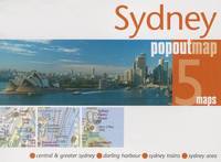
Maps, PopOut
Sydney PopOut Map
map. Good. Access codes and supplements are not guaranteed with used items. May be an ex-library book. unknown
Bookseller reference : 1845879619.G ISBN : 1845879619 9781845879617
|
|
|
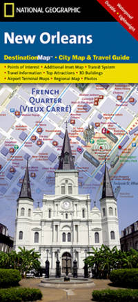
National Geographic Maps
National Geographic Destination City Map New Orleans
Natl Geographic Maps 2010. Sheet map. New. map edition. 2 pages. 9.00x4.25x0.25 inches. Natl Geographic Maps unknown
Bookseller reference : x-1597754145 ISBN : 1597754145 9781597754149
|
|
|
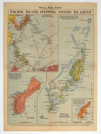
[PACIFIC - WORLD WAR II MAP].
Pacific Island Stepping Stones to Japan.
Chicago.: Chicago Daily Tribune. 28 September1944. Colour pictorial map on a single newspaper leaf archivally laid down on linen 50 x 39.2 cms; 59.3 x 43.3 cms sheet including captions faint toning to fold lines very good condition. Vivid colour maps of the Palau Islands Guam and Saipan in the Marianas and an inset location map published in the "Chicago Daily Tribune" in September 1944 months after the landing of US and Allied Forces in the offensive against the Japanese during the Pacific War. . Chicago Daily Tribune. unknown
Bookseller reference : 208880
|
|
|
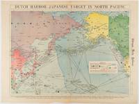
[WWII MAP OF EAST ASIA & THE PACIFIC]. WISNER, W. H.
Dutch Harbor -- Japanese Target in the North Pacific.
Chicago.: Chicago Daily Tribune. Friday June 51942. Printed colour map on a single newspaper leaf 37.5 x 53.2 cm; 44.7 x 59.8 cm sheet inset legend marginal browning and at the folds but in remarkably bright very good condition. Strategic map published in the Chicago Daily Tribune "The World's Greatest Newspaper" on June 5th 1942 two days after the Japanese attack on Dutch Harbor the site of the US army and navy bases in the Aleutians and as it transpired at the outset of the Battle of MIdway. The owner and proprietor of the Tribune Robert McCormick was staunchly against the United States entering the war and had firm views once it had occurred that American resources should not be used defending the British Empire. Famously the Tribune published the "Victory Program" Roosevelt’s military plan to prepare the United States for possible entry into World War II and was subject to prosecution for an alleged violation of the Espionage Act relating to the newspaper’s front-page account of the Battle of Midway 4-7 June 1942. It became an important test case for the limits of free speech and censorship during war-time. <br> <br>The Legend shows territorial Control of Ocean Areas marking Japanese Naval and Air bases as of 1941 and "according to latest reports" those established in the first six months of 1942. Also shown are pre-war sovereignties as at the bombing of Pearl Harbour on December 7th 1941. The Anson Archipelago is shown but a question mark "indicates islands etc. whose existence or give position is doubtful…". . Chicago Daily Tribune. unknown
Bookseller reference : 180751
|
|
|
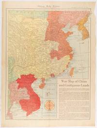
[WWII MAP OF CHINA]
War Map of China and Contiguous Lands.
Chicago.: Chicago Daily Tribune. January 151942. Printed colour map on a single newspaper leaf 53 x 40.7 cm; 59.8 x 45 cm sheet inset text box marginal browning and at the folds but remarkably bright in very good condition. WWII map of China showing most of China Indo-China Thailand and Korea with territory captured and controlled by Japan shaded in orange and red published by the Chicago Daily Tribune barely six weeks after the bombing of Pearl Harbour. The text on the map reads "Since 1937 China has been at war with Japan. Lacking many essentials of war the Chinese nevertheless have managed to maintain a front against the aggressors. China's principal life line is the Burma road shown on the map which starts at Lashio Burma and extends to Kunming Yunnan province where it links with connections to Chunking the present Chinese capital". <br> <br>Based on a Rand McNally map the Tribune briskly got to work issuing maps for readers showing the beginnings of the war with Japan. Later maps were also published for sale separately but remarkably few have survived. <br>"… the historic Chicago Tribune was an innovator in color inks and printing but also a pioneer in bringing colorful art in the form of illustrations photographs cartoons and advertisements to the average person in an everyday medium." see The Janet A. Ginsburg Chicago Tribune Collection Michigan State University Libraries. . Chicago Daily Tribune. unknown
Bookseller reference : 180794
|
|
|
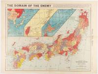
[WWII MAP OF THE JAPANESE EMPIRE]
The Domain of the Enemy
Chicago.: Chicago Daily Tribune. December 121941. Printed colour map on a single newspaper leaf 41.5 x 53 cm; 45.1 x 59.9 cm sheet three inset maps of the Japanese Empire; Taiwan and Ryukyu Islands; and Hokkaido and Chisima marginal browning and at the central fold but remarkably bright in very good condition. Map of the Japanese Empire ominously titled published in the Chicago Daily Tribune one week after the bombing of Pearl Harbour. Prefectures are attractively coloured. <br> <br>Based on a Rand McNally map the Tribune briskly got to work issuing maps for readers showing the beginnings of the war with Japan. Later maps were also published for sale separately but remarkably few have survived. <br>". the historic Chicago Tribune was an innovator in color inks and printing but also a pioneer in bringing colorful art in the form of illustrations photographs cartoons and advertisements to the average person in an everyday medium." see The Janet A. Ginsburg Chicago Tribune Collection Michigan State University Libraries. . Chicago Daily Tribune. unknown
Bookseller reference : 180789
|
|
|
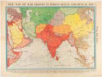
[WWII MAP OF ASIA] WISNER, W. H.
New Map of War Fronts in Indian Ocean and Bengal Bay.
Chicago.: Chicago Daily Tribune. April 211942. Printed colour map on a single newspaper leaf 37.5 x 53.2 cm; 60 x 45 x 59.6 cm sheet marginal browning and at the folds but remarkably bright in very good condition. World War II map of Asia save for Japan showing British allies colonies and lines of supply and marking Japanese territorial occupation published in the Chicago Daily Tribune "The World's Greatest Newspaper" in April 1942. <br>"The Indian Ocean and the Bay of Bengal are the strategic waters in this campaign in which the occupied parts of Burma and the Andaman Islands serve as bases" caption <br>". the historic Chicago Tribune was an innovator in color inks and printing but also a pioneer in bringing colorful art in the form of illustrations photographs cartoons and advertisements to the average person in an everyday medium." see The Janet A. Ginsburg Chicago Tribune Collection Michigan State University Libraries. . Chicago Daily Tribune. unknown
Bookseller reference : 180782
|
|
|
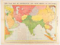
[WWII MAP OF ASIA] WISNER, W. H.
New War Map of Continental Asia from Siberia to Singapore
Chicago.: Chicago Daily Tribune. January 91942. Printed colour map on a single newspaper leaf 37.2 x 53.4 cm; 45 x 59.9 cm sheet inset legend marginal browning and at the folds lower margin with small edges tears not affecting the caption but remarkably bright in very good condition. Rare map of Asia "Between Suez on the west and Shanghai on the east" showing territorial interests and theatres of war published in the Chicago Daily Tribune in January 1942 barely two months after the Uniited States had joined the war effort after the bombing of Pearl Harbour. Thailand and Vietnam "French Indo-China" are marked "Occupied by the Japanese" and north-eastern China similarly marked Iran "Anglo-Russian Occupation" and the Gulf states "British Ally". The caption notes that "The map inludes waters thru which runs the British life line from the Suez canal to remote Australia and New Zealand. Nearly half the people in the world live in the lands shown on this map--more than 450 million for example in China and more than 375 million in India". <br> <br>". the historic Chicago Tribune was an innovator in color inks and printing but also a pioneer in bringing colorful art in the form of illustrations photographs cartoons and advertisements to the average person in an everyday medium." see The Janet A. Ginsburg Chicago Tribune Collection Michigan State University Libraries. . Chicago Daily Tribune. unknown
Bookseller reference : 180760
|
|
|
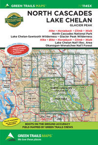
Green Trails Maps (Corporate Author)
North Cascades / Lake Chelan Glacier Peak Green Trail Map
Green Trails Maps 2021. Paperback. New. fol map edition. 2 pages. 9.00x6.00x0.20 inches. Green Trails Maps paperback
Bookseller reference : 1-1680515187 ISBN : 1680515187 9781680515183
|
|
|
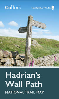
Collins Maps
Hadrian's Wall Path National Trail Map
Harpercollins Publishers 2023. Sheet Map Folded. New. 7.80x4.53x0.35 inches. Harpercollins Publishers unknown
Bookseller reference : __0008602980 ISBN : 0008602980 9780008602987
|
|
|
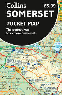
Collins Maps
Somerset Pocket Map: The Perfect Way To Explore Somerset
Harpercollins Publishers 2023. Sheet Map Folded. New. 1 pages. 5.55x3.50x0.98 inches. Harpercollins Publishers unknown
Bookseller reference : __0008580030 ISBN : 0008580030 9780008580032
|
|
|
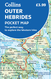
Collins Maps
Outer Hebrides Pocket Map: The Perfect Way To Explore The Western Isles
Harpercollins Publishers 2023. Sheet Map Folded. New. 2nd revised edition edition. 2 pages. 5.43x3.54x0.28 inches. Harpercollins Publishers unknown
Bookseller reference : __0008580057 ISBN : 0008580057 9780008580056
|
|
|
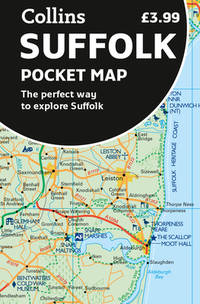
Collins Maps
Suffolk Pocket Map: The Perfect Way To Explore The Suffolk
Harpercollins Publishers 2023. Sheet Map Folded. New. 1 pages. 5.51x3.54x0.20 inches. Harpercollins Publishers unknown
Bookseller reference : __0008580014 ISBN : 0008580014 9780008580018
|
|
|
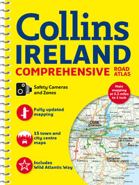
Collins Maps
Comprehensive Road Atlas Ireland
Harpercollins Publishers 2023. Spiral Bound. New. new ed edition. 160 pages. 11.65x8.62x0.47 inches. Harpercollins Publishers unknown
Bookseller reference : __0008412812 ISBN : 0008412812 9780008412814
|
|
|
A-Z Maps
London A-Z Pocket Atlas
Paperback / softback. New. A pocket sized paperback street atlas of Central London in full colour covering an area extending from the centre of London to: Brent Cross Golders Green Highgate Finsbury Park Stoke Newington Leytonstone Wanstead West Ham Thames Flood Barrier Eltham Grove Park Catford Streatham Wimbledon Barnes Bridge Willesden Junction Neasden. paperback
Bookseller reference : A9780008581770 ISBN : 0008581770 9780008581770

|
|
|
PopOut Maps
London PopOut Map: 3 PopOut maps in one handy pocket-size format
Sheet map folded. New. Let PopOut London guide you around this magical city. This genuinely pocket-sized map includes 3 PopOut Maps - central London the West End & the whole tube network. In addition there is a detail map of Theatreland and a bus route map. Ideal to pop in a pocket or bag for quick reference while exploring the city. unknown
Bookseller reference : A9781914515453 ISBN : 1914515455 9781914515453

|
|
 Receive by email
 Download as PDF document
 RSS feed


