1878réf. 82047Zamora Imprenta y litografia de Jose Gutierrez 1878 1 vol. relié gr. in-8, bradel percaline verveine, dos lisse avec pièce de titre de chagrin rouge et fleuron doré au dos, 294 pp., nombreux croquis et planches lithographiques réalisées à partir de dessins de l'auteur. Petites taches sans gravité à la percaline et ex-dono manuscrit, sinon bonne condition.
1862Piano nautico tratto dal raro portolano "Recueil des Plans des Ports & Rades de la Mer Méditerranée de la Mer Noire & de la Mer d'Azof" edito a Marsiglia da Joseph Maistre nel 1862 e basato sulle carte nautiche dle Depote de la Marine francese. Litografia, in buono stato di conservazione. Nautical chart taken from the rare pilot "Recueil des Plans des Ports & Rades de la Mer Méditerranée de la Mer Noire & de la Mer d'Azof" published in Marseille by Joseph Maistre in 1862 and based on the nautical charts of the French Depote de la Marine.Lithograph, very good condition.
1880réf. 231371880 Paris, Hachette et Cie, 1880 ; Col. des Guides Joanne: ,grand in-16,pleine percaline bleue, (4), CXXXIX, (1), 740 pp, 81 pp. de publicités, 13 cartes et 21 plans, cartonnage d'éditeur en percaline bleue, dos lisse orné, 13 cartes , dont 2 profils orographiques, et 21 plans. Nouvelle édition. Le tableau des colonies espagnoles et portugaises annoncé dans la table (p. 710) n'existe pas, la carte sous l’étui est presente en bon état.
2000Paper wrappers, 4to. , 31 pages. In Catalan, Spanish, English, Hebrew, and French. Jerusalem Girona Jerusalem : Images and text between two cities. Beautifully printed, Full page color illustrations, photographs, and facsimiles of art and manuscripts from Jewish Girona. Very good condition. (SEF-35-3)
1998Photocopied packet in paper binder, 17pages. In Catalan. Articles from a variety of Spanish newspapers and magazines on the celebration of Hanukkah in the Jewish community of Girona. Includes pictures of menorah lighting, and of the chief Rabbi Eliahu Bakshi Doron at the ceremony. Very good condition. (SEF-35-2)
2000Paper brochure, [7] pages. Full color brochure for tourists on the history of Jews in Girona. With small map of the Jewish quarter. Very good condition. (SEF-35-6)
Coimbra, Imprensa da Universidade, 1933 ["Scriptores Rerum Lusitanarum"]. Folio; XXIII - 115 pp., mas dos láminas fotográficas aparte, con reproducción de la primera y última hojas del manuscrito original. Cubiertas originales.
réf. 13962Paris, Librairie Internationale, Bruxelles, A. Lacroix, Verboeckhoven et Cie, 1869 15 x 23, 399 pp., broché, bon état (sauf dos abîmé)
1743réf. 98100Paris Robinot - Dupuis - la veuve Amaury 1743 1 vol. relié in-12, veau brun, dos à nerfs avec pièce de titre de maroquin rouge, caissons ornés aux petits fers dorés et fleuron central, filet à froid en encadrement des plats portant armes dorées au centre, guirlande dorée sur les coupes, tranches rouges, 4 ff. + XCVIII + 236 pp. + 12 ff. (table + approbation), 3 cartes dépliantes. Bon exemplaire de ce manuel "à l'usage de Monseigneur le Comte de la Marche". Aux armes de la ville de Besançon (aigle germanique et colonnes d'Hercule) à la devise "Utinam". 3 ex-libris manuscrits anciens de la famille Veauvillarensis. En bonne condition.
Madrid, por Don Antonio de Sancha, 1782. 4to. menor; XIX pp., 345 pp. Encuadernación en piel de la época, con lomera ornada y tejuelo.
1832réf. 244031832 La Caricature. Journal. Morale, Religieuse, Littéraire, Scénique - La Caricature ( Journal) No 93. Pl[anche] 189. [Paris] Becquet for Maison Aubert [16 August 1832]. Lithograph. Overall paper size: 21.3 × 32.6cm.; caricature de Grandville et Julien, parue sous le n° 93 dans le journal La Caricature, le 16 août 1832. Talleyrand est à terre , pour "ramasser et remettre en place " les souverains et les princes européens que la "Liberté", invisible ici, s'apprête à faire tomber. C'est don Miguel, roi du Portugal, que le diplomate tient dans sa main droite. A demi caché, le jeune duc d'Orléans, fils aîné du roi Louis-Philippe.Satirical print showing an allegory of Liberty fighting against the monarchical principle by attempting to upset the political arena with a revolutionary bowl. Her opponent in the ‘bowling alley’, a barren hillside outside a castle, is the seasoned diplomat Talleyrand, who is sitting on the ground facing her, his crutch visible to the right. The skittles are miniature images of European princes; King Louis Philippe is recognizable from behind in the centre of the print, and half-hidden in front of him, is his eldest son, the young Ferdinand-Philippe Duc d’Orleans. Supporting himself with his left hand, Talleyrand has restored to its place the diminuative effigy of Dom Miguel I, the auto- cratic young ruler of Portugal, with his right hand.A vitriolic caricature of all members of the July Monarchy govern- ment, mocking its repression of the opposition, and its weak foreign policy. Louis Philippe, represented as a fat, effeminate king wearing a toga, is accompanied by a decadent family and scheming, corrupt ministers. The composition is dominated by Talleyrand to the left who is portrayed as Vulcan, forging chains and protocols. He is sitting on netting with which he ensnares the world; a fleur-de-lys is tattooed on his right forearm; his orthopaedic shoe is on the correct foot and his crutch is partly buried under documents to his right.
1991Hardcover, 4to, 178, 44 pages. : illustrated. In Hebrew and English. SUBJECT (S) : Jews -- Afghanistan. Judaism -- Liturgical objects -- Afghanistan -- Pictorial works. Synagogen. Liturgische voorwerpen. Joden. "Survey of synagogues and their treasures at the Jerusalem index of Jewish art. " Includes bibliographical references. Maps printed on end papers. Light wear to covers. Very good condition. (SEF-23-30)
19914to, 178, 44 pages. : illustrated. In Hebrew and English. With lengthy inscription from editor on half title page. SUBJECT (S) : Jews -- Afghanistan. Judaism -- Liturgical objects -- Afghanistan -- Pictorial works. Synagogen. Liturgische voorwerpen. Joden. "Survey of synagogues and their treasures at the Jerusalem index of Jewish art. " Includes bibliographical references. Maps printed on end papers. Very good condition. (SPEC-23-3).
London: Jews College, 1918. Cloth. 8vo. 59 pages. Bound with: Hirschfeld. JEFETH B. ALI'S ARABIC COMMENTARY ON NAHUM: WITH INTRODUCTION, ABRIDGED TRANSLATION AND NOTES (London: Jews College, 1911. 42 pages) . Hirschfeld (18541934) was a scholar of Judeo-Arabic literature. Hirschfeld, who was born in Thorn, Prussia, received his doctorate from Strasbourg (1878) . He emigrated to England in 1889 and taught first at Montefiore College in Ramsgate. Hirschfeld's chief interest lay in the interplay between the Arab and Jewish cultures as well as in the Arabic literature of the Jews. Hirschfeld wrote numerous articles in various journals concerning problems of Arabic and Hebrew philology and bibliography; of especial importance is a series of essays concerning the Arabic fragments in the Cairo Genizah (JQR, vols. , 1520, 190308) (EJ editorial staff) . SUBJECT(S) : Bible. O. T. Genesis -- Criticism, interpretation, etc. Gilt lettering on spine. Slight bumping to bottom edge. Patterned endpapers. In Very Good condition. (SEF-5-4x) . Price is for both works together.
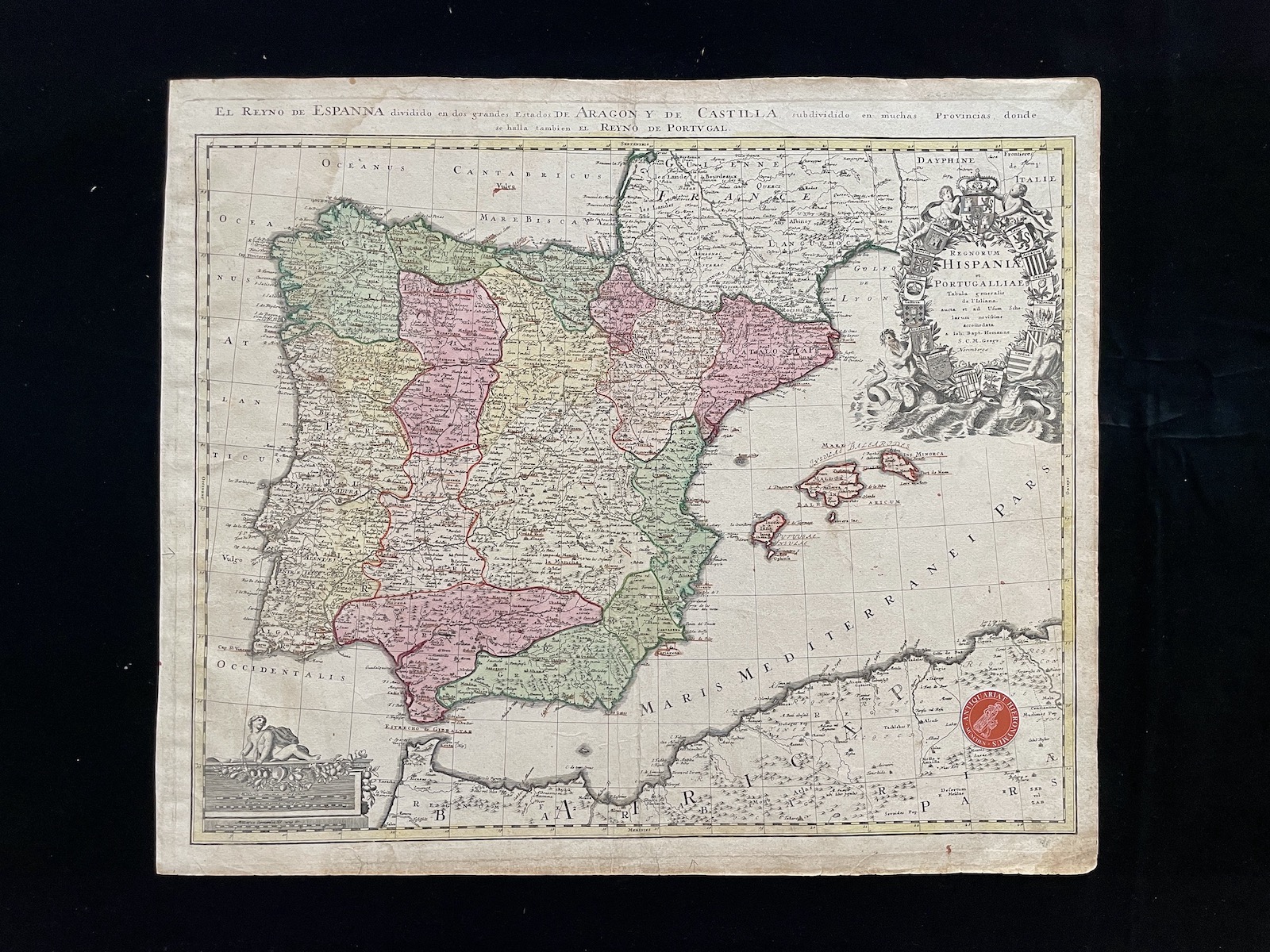
1730réf. 12905Nürnberg, Homann Erben, um 1730. Kupferstich, altkoloriert. Blattgröße: 53,5 x 63 cm, Druckspiegel: 51 x 61 cm [2 Warenabbildungen]
1598Carta tratta dalla prima edizione della "Cosmographia Universalis" di Paul Merula , stampata ad Amsterdam nel 1605. Le mappe usate per illustrare la prima edizione della Cosmografia di Merula sono realizzate nel 1598 da Jodocus Hondius e Pieter Van den Keere (Kaerius) e quidni utilizzate dall'editore Cornelis Claesz per illustrare lavori di Apian, Linschoten e Merula. Incisione in rame, inserita uin una pagina di testo, in perfette condizioni. Taken from the first edition of "Cosmographia Universalis" by Paul Merula, printed in Amsterdam in 1605.The map was first issued in 1598 by Cornelis Claesz and engraved and realized by Jodocus Hondius and Pietre vand den Keere (Kaerius). Claesz used the plate to illustrate various works he published by Peter Apian, Jan van Linschoten, Paul Merula and others. Copperplate, inset in a page text, very good conditions. King pp. 80/81
1616Carta geografica tratta dal Tabularum Geographicarum contractarum libri septem di Petrus Bertius, edizione latina del 1616. L'opera contiene 219 carte che illustrano questa nuova versione della geografia del Bertius, per la prima volta pubblicata nel 1612 con le carte di Barent Langenes. Le carte derivano dal grande atlante di Mercator/Hondius, delle quali molte rappresentano una semplice riduzione. "After the death of Cornelis Claesz in 1609, Jodocus Hondius II became the new publisher of the work, composed by 7 parts in 1, with engraved title-page and 220 full-page engraved maps in text. All the maps were newly engraved and slightly larger in size, because Hondius was not able to acquire the original plates. With the new plates the work was definitely improved and enjoyed a growing demand of the public, which at that time had the choice between the Atlas Minor by Mercator and Bertius' Tabularum Geographicarum. The 219 plates, with the oval world map appearing twice, were produced to illustrate a new version of the geography of Bertius, published in 1616. According to King, their correct attribution is by Hondius, after Mercator and Hondius, taken from Bertius, who was only responsible for revising his text again" [cfr. G. King, Miniature Antique Maps]. Incisione in rame, perfette condizioni. A superior rival to the pocket Ortelius atlas appeared about 1598, under the imprint of Barent Langenes and Cornelis Claesz. Claesz also published the Tabularum Geographicarum contractarum libri septem, edition with texy by Petrus Bertius, in 1600. After the death of Cornelis Claesz in 1609, Jodocus Hondius II became the new publisher of the work, composed by 7 parts in 1, with engraved title-page and 220 full-page engraved maps in text. All the maps were newly engraved and slightly larger in size, because Hondius was not able to acquire the original plates. With the new plates the work was definitely improved and enjoyed a growing demand of the public, which at that time had the choice between the Atlas Minor by Mercator and Bertius' Tabularum Geographicarum. The 219 plates, with the oval world map appearing twice, were produced to illustrate a new version of the geography of Bertius, published in 1616. According to King, their correct attribution is by Hondius, after Mercator and Hondius, taken from Bertius, who was only responsible for revising his text again. "After the death of Cornelis Claesz in 1609, Jodocus Hondius II became the new publisher of the work, composed by 7 parts in 1, with engraved title-page and 220 full-page engraved maps in text. All the maps were newly engraved and slightly larger in size, because Hondius was not able to acquire the original plates. With the new plates the work was definitely improved and enjoyed a growing demand of the public, which at that time had the choice between the Atlas Minor by Mercator and Bertius' Tabularum Geographicarum. The 219 plates, with the oval world map appearing twice, were produced to illustrate a new version of the geography of Bertius, published in 1616. According to King, their correct attribution is by Hondius, after Mercator and Hondius, taken from Bertius, who was only responsible for revising his text again" [cf. G. King, Miniature Antique Maps]. Copperplate, in very good conditions. Koeman p. 42; King p. 96/99.