6 276 résultats
réf. 56-0278San Jose Calif.: Regal Map Co approved with additions 1961. Map. Purple on white print 17" x 21". Street map of Madera indicating U.S. highways state highways county roads schools and city limits. Backside includes tourist attractions. Pencil marks indicate zones 1 and 2 and the Southern Pacific rail lines. Scale 1 inch = 0.3 miles. San Jose, Calif.: Regal Map Co, approved with additions 1961. unknown
réf. 56-0269San Francisco Calif.: Southern Pacific Company 1909 reviewed 1961. Map. Set of thirteen blueline prints. Each approximately 13 x 55 inches. With multicolor lines indicating joint use of facilities by Southern Pacific Co. and Atchinson Topeka and Santa Fe Railway Co. Scale not indicated. San Francisco, Calif.: Southern Pacific Company, 1909, reviewed 1961. unknown
réf. 56-0374San Francisco Calif.: Southern Pacific Company 1945. Notes added 1961. Map. Blueline print 18" x 65" with red pencil indicating switching limits. Two maps joined together to indicate switching zones. From Wellsdale to Cantonment. Includes US Army Camp Adair. With Schedule of Property listing approx 15 transfers 1879-1945. Scale not indicated. San Francisco, Calif.: Southern Pacific Company, 1945. Notes added 1961. unknown
1965réf. 61662Washington DC: U. S. Government Printing Office 1965. Presumed first edition/first printing. Wraps. Good. No dust jacket as issued. Cover has some wear and soiling. Some page discoloration. 26r iv 412 p. Includes maps. Exhibits. 89th Congress 1st Session. House Document No. 237. This set of hearings heard from a broad spectrum of scholars and notables from the middle of the 20th century. U. S. Government Printing Office paperback
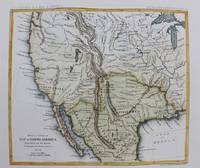
1861réf. M9549New York: Thomas Ford c.1861. Very Good. Notes: Detailed map of the western United States and Mexico. Size : 180x208 mm 7.09x8.19 Inches Coloring: Hand Colored Category: Maps Central America Mexico; Maps United States; Thomas Ford unknown
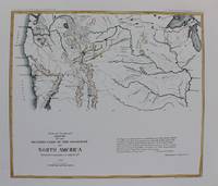
1861réf. M9550New York: Thomas Ford c.1861. Very Good. Notes: Map of the Western United States. Size : 178x205 mm 7.01x8.07 Inches Coloring: Hand Colored Category: Maps United States West; Thomas Ford unknown
1944réf. 66-1523Sper 1944. 1944. 5p. Yellow Card covers wraps. Lightly soiling to front.Near Fine copy. Paperback. Near Fine. Sper 1944. Paperback
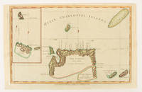
1784réf. 174895London.: Alexander Hogg at the King's Arms. circa1784. Engraved map on laid paper 21.4 x 33.7 cm inset of Gower's Simson's and Carteret's Island early outline hand colour trimmed to the plate mark at the top edge three small edge tears affecting the upper margin only slight paper toning but a most attractive map in very good condition. Fine impression of the Queen Charlotte's Islands Solomon Islands. It features the Swallow's track the ship's route taken by Captain Philip Carteret in 1767 the British naval officer and explorer who participated in two of the Royal Navy's circumnavigation expeditions in 1764–66 and 1766–69. . Alexander Hogg at the King's Arms. unknown
19794to [29.5 x 21 cm]; [xiv], 386 pp, 107 colored illustrations on plates, 371 monochrome illustrations on plates, bibliography, index. original brown cloth, gilt title lettering on spine and cover, slight stain at lower spine else near fine in very good dj (short tear, light stain at edge). A picture of this book is available upon request by email. A profusely illustrated work based on the collection of the Tropen museum in Amsterdam but with consultations of collections in Netherlands and United Kingdom. It discusses each of the hundreds of prints and books, that were published in Netherlands, United Kingdom and Indonesia in the nineteenth century, with collations, details of publication, artists, engravers, biographical information, etc, with a section on early lithographic printing in Indonesia.
185112mo [19 x 13.5 cm]; 355, [iii, ads] pp, extra lithographed title page with vignette, frontis, plates, map, other engravings in text. original blind-stamped cloth with gilt picture on front cover, gilt spine title lettering, spine ends chipped, corner wear, very lightly foxed on few leaves, else very good solid copy. A picture of this book is available upon request by email. The illustrations include Kealakekua Bay, Kaahamunau, old Hawaiian idols, Lahaina at Maui, Wailuku, double canoe, coral island and the plate of surf-playing, an early plate of surfing. Smith C45: 'A good picture of the islands at that time'. Hill p. 51: 'This interesting work relates mainly to Cheever's wide travels among the Hawaiian Islands and to his observations of them. Much interesting data is included on the history and native culture of the islands. Chapters are given on the first Hawaiian college and on Hawaiian literature. Cheever predicted eventual American rule of the islands.' Hunnewell 30.
19118vo [22.5 x 15 cm]; 320 pp, frontis, 54 illustrations from photos on plates, foldout map of Philippine Islands, South China Sea to Siam, Sumatra showing route in red, with the errata sheet (often lacking), index, title page printed in red and black. original cloth with gilt spine title lettering, lightly foxed at outer edge, signature of R. G. Pennington on endpaper, a very good copy. A picture of this book is available upon request by email. Robinson 233. The author and her husband Talbot, a restless and dissatisfied explorer, went plant hunting in the Andaman and Nicobar Islands, and although the main purpose of the expedition, the author describes their travels to Rangoon, Siam, Singapore, Batavia and all parts in between as well with good descriptions of the peoples, their customs, conditions, etc, with plant hunting forming a small part of the book.
18718vo [23.5 x 16 cm]; xi, 375, 32 [ads] pp, frontis, 2 tinted maps including one folding, numerous engraved illustrations from drwgs including full-page, index. original pictorial gilt green cloth, corners and part of joint worn, very light foxing on a few leaves, a very good clean copy. A picture of this book is available upon request by email. Not in Hill. Hocken p. 269. The author's brother, R. H. Meade, edited the work from the original journals after he was killed in an accident. The author was a Lieutenant of English naval ships sailing in southern waters. Much of the book is on the expedition from Auckland to Lake Taupo in the northern island with good descriptions of the land and the native peoples. About a third of the book relates to the author's travels to various islands in the South Pacific including Solomon Islands, Norfolk Island, Friendly Islands, etc. 'Much valuable information on the country and a rapidly changing pattern of localities, all graphically recounted' (NZ National Biography). The illustrations are from the author's drawings.
18208vo [22.5 x 14 cm]; iv, 112 pp, folding engraved map frontis showing Indian Ocean, Africa, the routes; plan of that coast of Isle of France; plan of landing of British army in Mapou Bay, Isle of France; engraved view of Cape of Good Hope. later brown cloth with title lettering on paper spine label, interior is quite clean and near fine, very minor foxing. A picture of this book is available upon request by email. National Maritime Museum 453. Royal Geographical Society Catalogue 572. The ship was commanded by Captain Philip Beaver. Much of the work describes the British attack on the Isle of France. 'Prior was born at Lisburn, Ireland in 1790. He entered the navy as a surgeon, served abroad and at home, became Deputy-Inspector of Hospitals in 1843, and was knighted in 1858. He was the author of several popular works: Voyage to the Indian Seas in 1810-11; Memoirs of Edmund Burke (1824); Life of Oliver Goldsmith (1836); Life of Edmond Malone (1860). His Burke and Goldsmith have gone through many editions, and are still looked upon as standard works. He died 14th November 1869'. [A Compendium of Irish Biography]
réf. 52957P., Plon-Nourrit, 1908, in 8° relié demi-chagrin vert, dos à nerfs, couvetrure illustrée conservée, tête dorée, II-296 pages ; quelques infimes frottis.
réf. 18267636like new. unknown
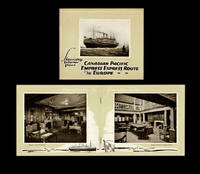
1923réf. 4745Montreal QC: Canadian Pacific Railway - Passenger Traffic Dept 1923. Paperback. Fine. 1923 Canadian Pacific pamphlet featuring photographs of the interiors of the Empress of Scotland 25000 tons the Empress of France 18500 tons and the Empress of Britain 15850 tons. Lower cover w. "Printed in U.S.A.-1923" at bottom edge. Stapled wraps 24mo size 5.5 inches tall pp. 20 illustrated throughout w. sepia halftone photo reproductions. A fine copy. OCLC locates no institutionally held copies of this scarce 1923 CPR pamphlet. n.b. At time of listing we also have CP's 1924 Empresses of the Atlantic Second Class to Europe - Steamship Interior Views ; 1924 Empress Express Route to Europe - Steamship Interior Views ; and 1924 Monoclass Cabin Service to Europe - Steamship Interior Views available as well as a fine copy of CP's May 1924 Preliminary Announcement of the Mediterranean Cruise of the S.S. Scotland on Feb. 9th 1925. Canadian Pacific Railway - Passenger Traffic Dept paperback
1996réf. 1-0821222996Bulfinch Pr 1996. Hardcover. New. 192 pages. 9.75x6.00x1.00 inches. Bulfinch Pr hardcover
2012réf. DADAX1461353726Springer 2012-11-05. Softcover reprint of the original 1st ed. 2002. paperback. New. 6.10x0.96x9.25. Buy with confidence. Excellent Customer Service & Return policy. Springer paperback
1886Roy. 8vo., First and Sole Edition, small, relatively unobtrusive damp-mark at lower outer blank margin (nowhere affecting text); strongly bound in modern grey boards, paper label lettered and ruled in black on upper board, original printed wrappers preserved, uncut, a good, sound copy of a scarce work. A SIGNED PRESENTATION COPY FROM THE AUTHOR'S WIFE WITH HER SIGNED HOLOGRAPH INSCRIPTION ON FRONT FREE ENDPAPER. With publisher's advertisement leaf bound in at end. Scarce. Ferguson 16696.
1921réf. 613943Montreal: Canadian Pacific Railway 1921. 1st. Softcover. Good/None. 24 pages. Softcover booklet. Illustrated with black & white photographs and drawings and fold-out illustration of the "Quadruple Screw Turbine Steamship Empress of France" in rear of booklet. Center 2 pages loose from booklet. Heavy foxing to covers and to edges of front and rear preliminary pages. Clean unmarked text. Record # 613943 Canadian Pacific Railway paperback
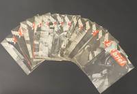
1945réf. 5514Set of 17 issues of Brief all from 1945. Each issue includes a full page photo of a pin-up girl on the back cover. Models include: Marguerite Chapman Virginia de Luce Lana Turner Belita Dorothy Morris Ava Gardner and many others. In addition to being a news and information publication Brief also strives to acquaint the men with the accomplishments of the personnel of AAFPOA. Creasing and occasional fold lines down middle a few have some water staining to back wrap see images. 18 pp. 9 x 12 inches. Complete list of issue dates: 9 Jan 6 Feb 13 Feb 20 Feb 27 Feb 6 March 13 March 5 June 12 June 19 June 26 June 3 July 10 July 24 July 7 Aug 14 Aug 28 Aug. Information and Education Division of AAFPOA paperback
18988vo [21 x 14 cm]; xv, 272 pp, frontis, double page colored chromolithograph of the Queensland flowering cotton tree, 15 other plates, one illus, folding colored map. original pictorial gilt cloth, gilt lettering, small ink mark on top of spine, light foxing on some leaves, else very good. A picture of this book is available upon request by email. Rowan was both a fine botanical and wildlife artist and an explorer, acclaimed internationally for her wildflower paintings. "Flower Hunter is a book of travel and adventure, the type of book then fashionable, because the world knew less of its far places than it does today. . . Ellis knew how to hold her audience, her breathless adventures are tinged with fantasy. . ." (Hazzard in Australia's Brilliant Daughter). This is Rowan's only book on her travels, based on two journeys to Queensland in northern Australia and to New Zealand. Most of the plates in the book are from her paintings.
184212mo [17.5 x 11.5 cm]; 440, 16 [ads] pp, folding map frontis, extra engraved title page with engraved view of Raiatea, table, index. later half calf, gilt title lettering on leather spine label, gilt decorations on spine, marbled boards, minor foxing in margins of a few leaves at end, else fine and clean condition in attractive binding. A picture of this book is available upon request Taylor 82: 'Full coverage of Oceana generally'. Ferguson 4141. Hill 558: 'Important and popular text'. The purpose of the work was to study 'the actual condition of the inhabitants in regard to civilization, commerce and the arts of social life'. The work includes Marquesas, Hervey or Cook's Islands, Tonga, Fiji, Navigators Islands, New Hebrides, Solomon, Sandwich Islands, Society Islands, New Zealand, etc.
1969réf. 371291Union Pacific Railroad. Missouri Pacific Lines. Southern Pacific Company 1969. First Edition. Softcover. Near fine pamphlet copy; edges slightly dulled. Particularly well-preserved overall; tight bright and clean. Physical description; Approximately 20 pamphlets; 22 cm. Subjects; Railroads; United States. Railways; United States. Trains. Trains; history. Union Pacific Railroad. Missouri Pacific Lines. Southern Pacific Company paperback
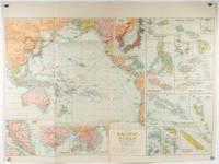
1930réf. 205997Sydney: H.E.C. Robinson. Circa1930s. Printed colour maps in all 65.5 x 99cm the main map roughly 50 x 65 cm on a single sheet 76 x 101.3 cms; a little carelessly folded decorative blue title cover a little dusty and a few fold splits and edgewear but in good condition. The exceptional feature of this map are the twenty six large scale inset maps of Pacific islands including: Malay States Singapore Hong Kong these at lower left Japan Philippine Islands Hawaiian Islands Fiji Solomon Islands Western and Eastern Samoa Tahiti Saipan New Caledonia and Dependencies and many others. The main map of the Pacific Ocean stretches from Southeast Asia including all of Australia and New Zealand the west coast of the Americas the Kamchatka Peninsula Manchukuo Manchuria and most of China. Korea and Taiwan are marked as Japanese Territory. Possessions of Britain France the Netherlands and the United States are highlighted. An incredibly rich source of information on the Pacific theatre during the years leading up to World War II. From the Sydney publisher H.E.C. Robinson the firm founded in 1895 by Herbert Robinson 1857-1933 a founder of the Royal Geographical Society of Australasia. . H.E.C. Robinson. unknown