6.355 Ergebnisse
Best.-Nr. 58-0542Portland Ore.: Southern Pacific Company n.d. Blueline print 24 inches x 55 inches. From Station Point Page to approximate 3 miles south. With Isaac Hutchins Donation Land Claim Leonidas McFarland donation claim. Includes Schedule of Property listing 8 transfers 1870-1896. Scale 1 inch = 400 feet. Portland, Ore.: Southern Pacific Company, [n.d.] unknown
Best.-Nr. 56-0206San Francisco Calif.: Southern Pacific Company 1958. Map. Blueline print. 24 x 54 inches. Includes Pleasanton Rancho El Valle Arroyo del Valle Laguna or Sunol Creek with Schedule of Property Acquisition Date Original Grantor/Grantee Instrument of Transfer and Remarks of Sale for 19 transfers 1868- 1958. Scale: 1 inch = 400 feet. Photo of detail. San Francisco, Calif.: Southern Pacific Company, 1958. unknown
Best.-Nr. 58-0549San Francisco Calif.: Southern Pacific Company 1951. Blueline print 24 inches x 55 inches. From Willow Ranch to California-Oregon State Line. Includes Cottonwood Creek. No structures listed detailed signal and track measurements. With Schedule of Property listing approx 30 transfers 1861-1951. Scale: 1 inch = 1000 feet. San Francisco, Calif.: Southern Pacific Company, 1951. unknown
Best.-Nr. 56-0215San Francisco Calif.: Southern Pacific Company 1928. Map. Blueline print. 24 x 56 inches. Includes town of Fowler Schedule of Property with approximately 30 transfers. Scale: 1 inch = 400 feet. San Francisco, Calif.: Southern Pacific Company, 1928. unknown
Best.-Nr. 56-0302San Francisco Calif.: Southern Pacific Company n.d. Map. Blueline print 24" x 55" with red pencil indicating switching limits. Includes Santa Cruz and station point Eblis. From San Lorenzo Cottonwood St and River St to the north to Bay of Monterey and Santa Cruz St to the south. Scale 1" = 200'. San Francisco, Calif.: Southern Pacific Company, [n.d.] unknown
Best.-Nr. 56-0352San Francisco Calif.: Southern Pacific Company 1923. Map. Blueprint 24" x 55". No details listed other than Southern Pacific Railroad land unnamed County Road and railroad track measurement markings. Scale 1" = 100'. San Francisco, Calif.: Southern Pacific Company, 1923. unknown
Best.-Nr. 56-0325San Francisco Calif.: Southern Pacific Company 1961. Map. Blueline print 24" x 55". Includes three Miller and Lux subdivision plots no buildings included. With Schedule of Property listing approx. 30 transfers 1888-1961. Scale 1" = 400'. San Francisco, Calif.: Southern Pacific Company, 1961. unknown
Best.-Nr. 58-0538San Francisco Calif.: Southern Pacific Company 1956. Blueline print 24 inches x 55 inches. From northwestern tip of Sierra Lands development to Ash Slough. With Sierra Vista Lands Subdivisions Chowchilla River. Includes Schedule of Property listing approx 20 transfers 1872-1956. Scale 1 inch = 400 feet. San Francisco, Calif.: Southern Pacific Company, 1956. unknown
Best.-Nr. 56-0458San Francisco Calif.: Southern Pacific Company 1945. Blueline print 24" x 55". Sheet one of three. Switching limits indicated in colored pencil. From Cherokee Lane to Grant Street with approx 1 1/2 miles north and 2 miles south of station point Lodi. Includes Lodi Barnhart Tract. With Schedule of Property listing approx 110 transfers 1868 - 1945. Scale 1" = 400'. San Francisco, Calif.: Southern Pacific Company, 1945. unknown
Best.-Nr. 58-0533San Francisco Calif.: Southern Pacific Company n.d. Blackline print 24 inches x 55 inches. From Garcia Avenue to Lincoln Avenue along Hemlock Avenue and California Drive. With Millbrae Burlingame Gate Bayside Manor Millsdale Industrial Park. Scale 1 inch = 200 feet. San Francisco, Calif.: Southern Pacific Company, [n.d.] unknown
Best.-Nr. 56-0221San Francisco Calif.: Southern Pacific Company 1938. Map. Blueline print. 24 x 56 inches. With red and orange pencilling. Map of Mayfield with Schedule of Property Acquisition Date Original Grantor/Grantee Instrument of Transfer and Remarks of Sale for approximately 9 transfers 1809-1938. Scale: 1 inch = 200 feet. Includes index map showing sheets of Val. Sec. Scale: 1 inch = 1 mile. San Francisco, Calif.: Southern Pacific Company, 1938. unknown
Best.-Nr. 56-0358Los Angeles Calif.: Southern Pacific Company 1961. Map. Blueline print 24" x 58". Includes town of Yuma with detailed railroad yard. Scale 1" = 100'. Joined with 24" x 55" aea map scale 1" = 400' with zones notated. From California border to beyond Gila Project canal and Air Force access road. Los Angeles, Calif.: Southern Pacific Company, 1961. unknown
Best.-Nr. 56-0327San Francisco Calif.: Southern Pacific Company 1956. Map. Blueline print 24" x 55" with yard limit indicated in red pencil. Includes city of Mendota Associated Pipe Line Co and ajoining land. With Schedule of Property listing approx. 30 transfers 1888-1956. Scale 1" = 400'. San Francisco, Calif.: Southern Pacific Company, 1956. unknown
Best.-Nr. 56-0247San Francisco Calif.: Southern Pacific Company 1950. Map. Blueline print 24" x 56". Map of Mountain View CA with Switching Limits. Includes central Mountain View Estrada Park lots 1-3 of Castro and Calderon subdivision. W/ Schedule of Property approx. 25 transfers 1864-1950. Scale 1" = 200'. San Francisco, Calif.: Southern Pacific Company, 1950. unknown
Best.-Nr. 58-0527San Francisco Calif.: Southern Pacific Company 1961. Blackline print 24 inches x 55 inches. From Tujunga Avenue to Empire Avenue and Hollywood Way along Van Owen Street. With Includes Schedule of Property listing approx 40 transfers 1902-1961. Scale 1 inch = 200 feet. San Francisco, Calif.: Southern Pacific Company, 1961. unknown
Best.-Nr. 56-0258San Francisco Calif.: Southern Pacific Company 1942. Map. Blueline print. 24 x 56 inches. With red pencil indicating switching zones. Includes Pioneer Mount Shasta and vicinity. With Shedule of Property approx. 50 transfers listed 1866-1959. Scale: 1 inch = 400 feet. San Francisco, Calif.: Southern Pacific Company, 1942. unknown
Best.-Nr. 56-0342San Francisco Calif.: Southern Pacific Company n.d. Map. Blueline print 24" x 55". Includes Salt River station points Tempe and Tempe Junction. Includes Schedule of Property with 3 transfers 1875-1887. Scale 1" = 400'. San Francisco, Calif.: Southern Pacific Company, [n.d.] unknown
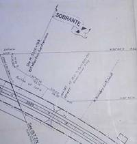
Best.-Nr. 56-0442San Francisco Calif.: Southern Pacific Company 1932. Blueline print 24" x 55". From approx 1200' west of Sobrante Avenue juncture with railroad tracks to 1200' east of Sobrante station point. With Sobrante Park. Includes Schedule of Property listing approx 20 transfers 1872-1932. Scale 1" = 100'. San Francisco, Calif.: Southern Pacific Company, 1932. unknown
Best.-Nr. 56-0209San Francisco Calif.: Southern Pacific Company 1931. Map. Blackline print. 24 x 56 inches. Red and blue highlighting. Notes added in 1942. includes Rancho Los Medanos with Schedule of Property Acquisition Date Original Grantor/Grantee Instrument of Transfer and Remarks of Sale for 18 transfers 1873- 1931. Scale: 1 inch = 400 feet. San Francisco, Calif.: Southern Pacific Company, 1931. unknown
Best.-Nr. 58-0546San Francisco Calif.: Southern Pacific Company 1952. Blueline print 24 inches x 55 inches. From approx 5 miles south of Station Point Davis Creek to approx 2 miles north of abandoned Station Point Garret. No structures indicated extensive listing of signal and track measurements. With Schedule of Property listing approx 30 transfers 1875-1952. Scale 1 inch = 1000 feet. San Francisco, Calif.: Southern Pacific Company, 1952. unknown
Best.-Nr. 56-0460San Francisco Calif.: Southern Pacific Company 1937. Blueline print 24" x 56". Sheet three of three. Switching limits indicated in red pencil. From Live Oak Colony to approx one mile east of station point Victor. Includes station points Victor Roma formerly Franklyn. With Schedule of Property listing approx 20 transfers 1882 - 1936. Scale 1" = 400'. With inset map showing details of property scale 1" = 100'. San Francisco, Calif.: Southern Pacific Company, 1937. unknown
Best.-Nr. 58-0532San Francisco Calif.: Southern Pacific Company n.d. Blackline print 24 inches x 55 inches. From Vineland Avenue to Victory Boulevard between Burbank Boulevard and Magnolia Boulevard. Includes Rancho Ex-Mission de San Fernando Rancho Providencia Rancho San Rafael. Scale 1 inch = 400 feet. San Francisco, Calif.: Southern Pacific Company, [n.d.] unknown
Best.-Nr. 56-0283San Francisco Calif.: Southern Pacific Company 1945. Map. Blueline print 24" x 56" with red pencil notation. Includes town of Sunol Alameda Creek Laguna or Sunol Creek. From ex-mission land southwest to railroad tracks towards Tracy northeast. With Schedule of Property listing approx 25 transfers 1868-1945 with extensive notes. Scale 1" = 400' San Francisco, Calif.: Southern Pacific Company, 1945. unknown
Best.-Nr. 56-0244San Francisco Calif.: Southern Pacific Company 1936. Map. Blueline print 24" x 56" with purple pen and red pencil notation. Includes Washinton Township Decoto Niles Pabrico Rancho Arroyo de la Alameda. With Schedule of Property approx. 30 transfers. Scale 1" = 400'. San Francisco, Calif.: Southern Pacific Company, 1936. unknown
Best.-Nr. 56-0419San Francisco Calif.: Southern Pacific Company 1953. Blackline print 24" x 56". From G Street to Coronado Avenue along Bay Boulevard National Avenue. Includes Chula Vista Otay Palm City and G.H. Colton Henry Eummelen Luther Johnson F. Heilman plots. With Schedule of Property listing 27 transfers 1895-1917. Scale 1" = 400'. San Francisco, Calif.: Southern Pacific Company, 1953. unknown