La Perouse, Jean-Francois de GalupBiblio.com
162 risultati
1786rif. 24580Paris 1786. Other. In excellent condition. 490 by 860mm 19¼ by 33¾ inches. Copper engraving uncolored as published. unknown
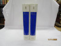
1968rif. 55058Amsterdam And NY: N. Israel and Da Capo Press. Near Fine. 1968. Hardcover. Two volume set; lacks atlas volume. Faux vellum gilt. Facsimile edition. Corners lightly bumped. Contents fine. The clear plastic DJs have some chips/tears. ; quarto . N. Israel and Da Capo Press hardcover
1968rif. 50398Amsterdam and New York: N. Israel and Da Capo Press 1968. Later printing. Hardcover. Very good condition. Quarto. 25391; 253117pp. Index. Plus facsimiles of the original 1799 title pages and 56 facsimile pages of the original prefaces and introductions. Publisher's mylar dust jackets. Faux vellum boards with gilt lettered blue labels on front covers and spines. "Bibliotheca Australiana #27 and #28." The text is complete in two volumes but this set lacks the atlas volume and is priced accordingly. Mylar with wear small chips and tears some tears larger. N. Israel and Da Capo Press hardcover
1968rif. 208132Amsterdam. Nico Israel. 1968. 4to. 539547pp. Publisher's mylar djs on text volumes. Sl.discolouration to the spine of the atlas volume. Scarce. Bibliotheca Australiana nos. 27 28 & 29 Facsimile re-issue of the London edition of 1799. An interesting French perspective on the arrival of the First Fleet in 1788. Amsterdam. Nico Israel. unknown
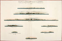
1797rif. 56369Paris: 1797. Eight profiles showing Mt. la Touche Baie de la Touche present Englefield Bay C. Hector present Cape St. James I. Kerouard Iles Sartine Scott Islands and Cap Blanc. The map is from the Voyages of La Pérouse who set sail from France in 1785 to continue the discoveries of Captain Cook. He was shipwrecked in 1788 but his narrative maps and views survived and were published in 1797. Thirty-eight years later the scattered remains of La Boussole and L'Astrolabe was discovered wrecked on a vicious reef on an atoll in the New Hebrides. Atlas Du Voyage De La Pérouse. Paris: Copper engraving. Very good condition; slight browning along the centrefold and foxing to wide margins a tear to the bottom margin along the centrefold not affecting the image. Hand coloured. Size: 58.5 x 43 cm. unknown
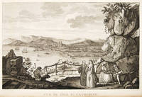
1797rif. 55649Paris. 1797. View of Brazil from the Voyages of La Perouse who set sail from France in 1785 to continue the discoveries of Captain Cook. He was shipwrecked in 1788 but his narrative maps and views survived and were published in 1797. Atlas Du Voyage De La Pérouse. Copper engraving. Very good condition. slight browing around edges but not effecting image. Uncoloured. Size: 40 x 25.5 cm. unknown
1799rif. 38451London: G.G. & J. Robinson 1799. Original copper engraving. This detailed map shows the south eastern part of Alaska. A fine copy of this engraving from Robinson's edition "usually considered to be the best one in English . and is extremely rare" Hill picturing and charting La Perouse's ill-fated voyage round the world. "La Pérouse's expedition was one of the most important scientific explorations ever undertaken to the Pacific and the west coast of North America . The charge to the expedition which took place between 1785 and 1788 was to examine such parts of the region as had not been explored by Captain Cook; to seek for an interoceanic passage; to make scientific observations on the various countries peoples and products; to obtain reliable information about the fur trade and the extent of Spanish settlements in California; and to promote the inducements for French enterprise in that quarter . La Pérouse and his men did important geographical research . The voyage also included the first foreign scientific group ever to visit California. La Pérouse sent dispatches back to France from Kamchatka and Botany Bay. The two ships then set sail from Botany Bay in 1788 and were never heard from again" Hill. It was not until the 1820s that the wrecks of his ships were discovered on a reef in the Santa Cruz group. When it became clear that something had happened to the expedition a decision was made to publish the journals he had transmitted home. Cowan p.383; Ferguson 288; Hill 2004 975; Howes L93 'b'; Lada-Mocarski 52; Sabin 38962; TPL 596; Wagner Cartography of the Northwest Coast 837-848 pp.199-201; Zamorano 49. G.G. & J. Robinson unknown
1800rif. 21185London 1800. Very good overall. Copper engraving of two Tlingit women of the Pacific Northwest. Port des Francais is now known as Lituya Bay in southeast Alaska. The engraving depicts the women at the sea coast seated under trees wearing fur cloaks one viewed in profile each with lip plates or labrets. Engraved by Deeves after a drawing by Prior. From Voyage de La Perouse Autour du Monde. 4to 8x 10" paper; 6 1/4 x 8 1/2" image. unknown
1798rif. 496London: G & T Robinson 1798. The English edition of a map published to accompany La Perouse' Voyage. G&T Robinson Nov. 1st 1798. Covers from the Gulf of Carpentaria to the Solitaire Islands to the Navigator Islands in the east and to above New Guinea. Charts Maurelle's tracks. G & T Robinson unknown
rif. elala4672London: G.G. and J.Robinson 1798. cfWagner 841 & Falk Alaskan Maps 1797-9 French edition. 16 ºî x 21 ºî 41.3 x 54.3 cm. engraving paper weakness at centre fold London: G.G. and J.Robinson, 1798 unknown
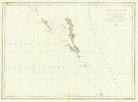
rif. elala4671Paris: 1797. This map shows La PÈrouseís 1786 northwest coast exploration route from Mount St. Elias on the Alaska-Canada border to ëBaie de Clonardí a cove on the west side of Graham Island. La PÈrouse was appointed to lead a French expedition which would further the scientific and geographical exploration of the northwest. He was also charged with continuing the search for the North-West passage from the Pacific side. Wagner Cartography Of The Northwest Coast Of America 841. Phillips Atlases 688. Falk Alaskan Maps 1797-9. 19 ºî x 26 æî. engraving paper flaws below upper border & lower margin [Paris: 1797] unknown
rif. elala4673London: G.G. and J.Robinson 1798. cfWagner 842 & Falk Alaskan Maps 1797-9 French edition. London. 16 ºî x 20 æî 41.3 x 52.1 cm. engraving paper weakness at centre fold London: G.G. and J.Robinson, 1798 unknown