12.209 resultados
ref. BN92838Veiatlas Norge: Veikart = road maps = Strassenkarten 1:300 000 : bykart = city maps = Stadtplane 1:20 000 Norwegian Edition Unknown Binding Veiatlas Norge: Veikart = road maps = Strassenkarten 1:300 000 : bykart = city maps = Stadtplane 1:20 000 Norwegian Edition Unknown Binding Veiatlas Norge: Veikart = road maps = Strassenkarten 1:300 000 : bykart = city maps = Stadtplane 1:20 000 Norwegian Edition Unknown Binding unknown
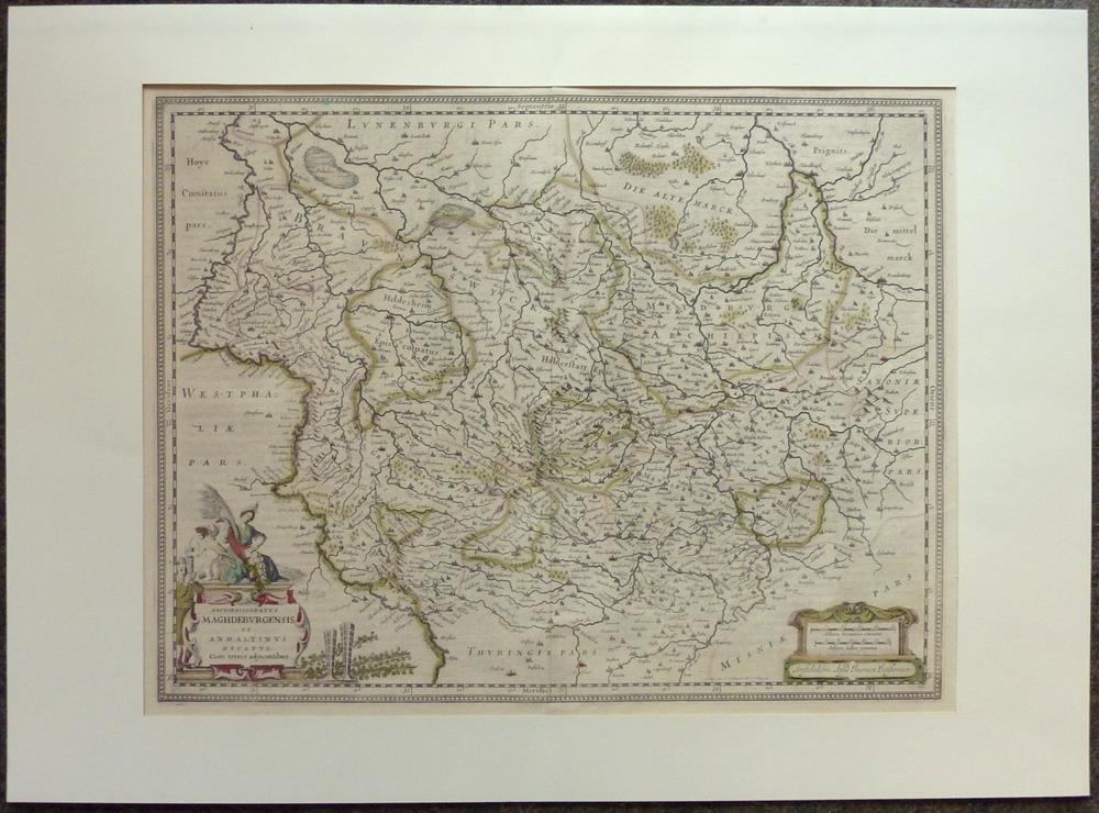
1680ref. 81228Amsterdam, Janssonius, [ca. 1680. 38 x 49 cm.
35,5 x 46 cm. (Blatt: 42 x 52 cm). *Sauber und sehr gut erhalten, sehr schöne Kolorierung.. Landkarten de
38 x 43,5 cm. (Blatt: 45 x 55 cm). *Die Orteliuskarte Württemberg. - In den oberen äußeren Ecken mit gebräuntem Wasserrand (außerhalb der Darstellung), ansonsten sauber und sehr gut erhalten. Landkarten de
ref. 5663Haut-Zambèze,voyage d’exploration en Afrique et retour par les chutes Victoria,le Matébeleland,Le Transvaal,Natal,Le Cap. In 4 demi-chagrin rouge époquetitre,roulette,filets dorés,filets à froid,faux-titre,portait de l’auteur sur papier de chine contrecollé sur vélin fort,sous serpente,titre avec vignette,331 pages,sur papier couché,nombreuses illustrations photos dans le texte et hors-texte,carte dépliante deux Royaumes de Marutse,(Ba-Rotsi)deux cartes dépliantes Paris Hachette & Cie 1898, très bon état
1696ref. 27968(Nürnberg, 1696). 25,5x47 cm. Kobberstukket planche, sammensat af 2 plader, over Karl Gustavs hæropstilling før overgangen over det tilfrosne Lillebælt.
1831ref. 55743(Gotha, Justus Perthes), 1831. Engraved map (34,5 x 43 cm.). Handcoloured in outline. Gestochen von Joh. Carl Ausfeld.
1696(Nürnberg, 1696). 25,5x47 cm. Kobberstukket planche, sammensat af 2 plader, over Karl Gustavs hæropstilling før overgangen over det tilfrosne Lillebælt.
1831(Gotha, Justus Perthes), 1831. Engraved map (34,5 x 43 cm.). Handcoloured in outline. Gestochen von Joh. Carl Ausfeld.
1939ref. 2092902141000906Tokyo Mikuraku 1939. Soft Cover. Fine. The book is in fine condition. Tokyo Mikuraku paperback
1659ref. 122141659 Limites aquarellées. 1 carte gravée sur cuivre, 43 x 53 cms. P. Sanson 1659
1928ref. 70989Chicago IL: Illinois Commerce Commission 1928. First edition. Mammoth lithograph map 52 ½ x 34 inches showing the railroad lines throughout the state and cities and towns they pas through with an inset detailed map of Chicago and vicinity 15 ¼ x 8 ½ inches and boxed panels for identification of the various railroads and "Passenger Terminals in Chicago" verso prints an index to counties and towns. Relatively uncommon OCLC locating 12 copies 6 in Illinois 4 in Wisconsin. Folded into 12mo printed light brown wrappers; several closed marginal tears into map one two-inch horizontal fold break else very good. Illinois Commerce Commission unknown
1928ref. 70989Chicago IL: Illinois Commerce Commission 1928. First edition. Mammoth lithograph map 52 ½ x 34 inches showing the railroad lines throughout the state and cities and towns they pas through with an inset detailed map of Chicago and vicinity 15 ¼ x 8 ½ inches and boxed panels for identification of the various railroads and "Passenger Terminals in Chicago" verso prints an index to counties and towns. Relatively uncommon OCLC locating 12 copies 6 in Illinois 4 in Wisconsin. Folded into 12mo printed light brown wrappers; several closed marginal tears into map one two-inch horizontal fold break else very good. Illinois Commerce Commission unknown books
1922Ex-library book with the usual stamps, stickers, etc. Binding is solid and text/interior is clean and free of marking of any kind. Bound compilation of the City Facts publication from the Author dating from Oct. 1, 1922 to March, 1927. Issues include: Dec. 1926, Nov. 1924, Oct. '22, Mar. '23, Jan. '24, Apr. '24, Oct. '26, Jul. '26, May '26, Dec. '25, Sept. '25, Apr. '25, Dec. '24, Nov. '24, (#4) Nov. '24 (#5), Apr. '24, Jan. '24, (#1), Jan. '24 (#2), June '23, Apr. '23, Mar. '23, Jan. '23, Dec. '22 (#'s 1 & 2) in special binding that incorporates a box containing (5) color 21" x 31 1/2 " maps of Buffalo, New York, and one of the surrounding area that are laminated in a fashion that incorporates cloth on the back side and depicting existing and planned street layouts, building sites, etc. Map titles are: Plan of Buffalo, Showing General Development [(2) from 1922], (2) Comprehensive Plan of Niagara Frontier, Buffalo of Tomorrow (with features on the Circuit Traffic Way and reasons for Niagara Square) and City Plan of Buffalo (1921) with three sub-maps: Buffalo traffic accidents 1917, One Day's Traffic Counts & Major Street Plan. With Bulletin # 4 -- one page ephemera containing a resolution known as the Buffalo Plan (1922) in poor condition & a circular advertising a $100. cash prize for naming New Circuit Traffic Way. About 1/4 of the pages of the City Facts have 1" tear at a fold from the side about 2/3rds way down the page, maps are not pristine, but Very Good. Heavy library binding in excellent condition.
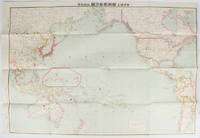
ref. 169329東京. Tokyo.: 九段書房.Kudan shobo. 大正十四 1925. Coloured folding Japanese map showing the military strength of Japan the United States and the United Kingdom in the Pacific original pictorial envelope scale not given. Some small holes at folds occasional light foxing a prior owner's signature on reverse minor wear envelope. Very good copy in like envelope. Map measures 54.4 x 78.8cm. The explanatory text in Japanese printed on the reverse in blue summarises the colonial possessions of the US and the UK as well as providing a comparison between the land size naval presence natural resources immigration issues and maritime transport capacities of Japan the United States and the United Kingdom. Legend indicates national regional provincial territorial boundaries canals undersea cables airline routes metropolitans capital cities mining fields hot springs ancient battle fields major trade ports Japanese embassies and consular offices. A large area marked 日本委任统治 "South Pacific Mandate" highlighted in a box is adjacent to Australian occupied Papua New Guinea. . 九段書房.[Kudan shobo]. unknown
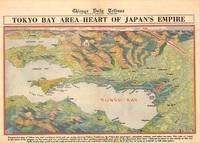
1945ref. 209335Chicago.: Chicago Daily Tribune. 28 July1945. Colour bird's eye view map 22.4 x 39.3 cms on a newspaper leaf trimmed to a half sheet 29.8 x 41.6 cms including caption slight toning at an old central fold the map in very good condition. Unrelated black and white photographic illustrations on the verso "Pre-flight Trainers used in Chicago to give ground instruction to would-be pilots" and "New rekindled Montauk Light Long Island N.Y." Map published in the Chicago Daily Tribune days before the bombing of Hiroshima on August 61945. "Perspective map of Tokyo bay and contiguous land and sea areas showing Tokyo Yokohama the Yokosuka naval base industrial sections and other features .In this map north is at the right instead of at the top - an expedient adopted to show all of the bay as large as possible in half page space." caption . Chicago Daily Tribune. unknown
ref. DADAX2067150529New unknown
196435 pages including 34 maps. Oblong 14" x 18". "This collection of county maps presents in detail basic geographical features of the northern lower peninsula. Also, it includes all types of roads, federal and state-owned lands, state and local parks, camp grounds, fishing sites, and other public recreational facilities." - from title page. Includes the following counties: Emmet, Cheboygan, Presque Isle, Charlevoix, Antrim, Otsego, Montmorency, Alpena, Leelanau, Benzie, Grand Traverse, Kalkaska, Crawford, Oscoda, Alcona, Manistec, Wexford, Missaukee, Roscommon, Ogemaw, Iosco, Mason, Lake, Osceola, Clare, Gladwin, Arenac, Oceana, Newaygo, Muskegon, Mecosta, Isabella, Midland, Bay. Average wear. Unmarked. Maps clean and bright. A sound copy. Book
194434.5" x 25" paper map. Identifies Roads, Railways, International Boundaries, Churches, Forts, Lighthouses, Woodlands. Average wear. Book
1964Pages 413-468 plus 4 pages of ads. Features: Cover Photo portrait Of The new King of the Hellenes, Constantine II, with Queen Frederika, at the funeral of his father; Photo of Princess Margaret with Kenneth Corney; Page of photos of celebrations upon the birth of Prince Edward; Two pages of dramatic photos and text from Cyprus - fighting in Ktima, threats of Turkish invasion, and first arrivals of the UN peace force; Photo-illustrated article on Paul, King of the Hellenes; Photo of riots in Phnom Penh; Photo of Geneva motor show; Photo of unveiling of statue of Pope Pius XII; Photo of 84-year-old Gen. Douglas MacArthur after surgery, escorted by Army Surgeon General Lieut. Gen. Leonard Heaton; Photo of the new president of Venezuela, Dr. Raul Leoni, receiving the sash of office from his predecessor, Pres. Betancourt; Page of photos of flooding in five states touching on the Ohio River basin include scenes near Williamsport, PA, the town of Sugar Grove, OH, Albany, IN, Shepherdsville, KY, an Ohio amusement Park, and Marietta; Photo of the first submarine ever built, the Fenian Ram, on display in Paterson New Jersey; Photo of Pope Paul receiving group of nuns recently expelled from the Sudan; Photo of jubilant George Lodge in Concord, New Hampshire where he defeated Sen. Goldwater and Gov. Rockefeller in the presidential primary; Photo of Independence Day children's party in Accra, Ghana, held by Mrs. Fathia Nkrumah, wife of the president of Ghana (also shown); Photo of the Royal Shakespeare Company applauding Yugoslavian president Tito at Belgrade; Book review of "King Edward VII" by Philip Magnus; Major coverage of Sardis excavations - part two; A survey of the 60 years of Anglo-French accord; One-page compilation of maps, text and photos describe's areas affected by the Anglo-French agreement, and the signatories to the document of April 8, 1904; Centrefold (free from staples) colour photos show the changing landscape of France; Entente Cordiale - page of historic photos illustrates France and Great Britain in peace and war; Entente Cordiale - page of photos of Anglo-French friendship since 1940; Page of photos illustrates how the English Channel is crossed by aircraft, ship, and train ferry, with artist's impression of future hovercraft car and passenger ferry; Impressive page of five aerial photos of huge French automotive manufacturing works - Renault, Simca, Peugeot, and Citroen; Two pages of photos illustrate developments in the aircraft and shipping industries of France today; One-page illustration of novelist, poet, broadcaster and one of the most vivid personalities living, Sir Compton McKenzie; Two pages of photos of the funeral of King Paul in Athens; Drawings of colonial America by John White; Photos of personalities of the week include Sir Newman Flower, Sir Knox Helm, Mr. R. G. Routh, Sir Robert Clark-Hall, Gen. von Lettow-Vorbeck, Sir R. Robinson, J. Brian Neill, C. Robin Mayer, Col. Joan E. Henderson, Lord Newton C. Ron Jacobs, J. Michael Cowman, Gen. A. Jolly, Jack Ruby (sentended for death), Capt. David I. Holland, Lieut. Harold W. Welch, Capt. Melvin J. Kessler, and James (Jimmy) Hoffa (convicted of bribery); Photo of the teapot collection of Rev. C. J. Sharp; Photo of ticket barrier smashed by derailed car at Hammersmith underground station; Photo of funeral for 16-year-old cat named Peter, Whitehall's chief mice catcher; Photo of Cambridge University women's rowing crew after their victory over Oxford on March 14; One-page photo of polar bear cubs seeing the world for the first time at Whipsnade Zoo; Photo of Angus Ogilvy greeting the England women's hockey team before a match versus Scotland at Wembley; Photo of automatic ticket reading barrier introduced by London transport at Chiswick Park station; and more. Unmarked with average wear. A sound vintage copy. Magazine
194738.5" x 26.75" map. Indicates sixty-seven coal mines and prospects. Extensive descriptive notes along right margin. Legend in left margin indicates the various formations shown on the map, including Gabriola, Northumberland, De Courcy, Cedar, Protection, Newcastle, Cranberry, Extension, Haslam and East Wellington, and Benson. Stored in original government-issued kraft envelope with some markings. Covers the area from Ladysmith Harbour north to Arbutus Point, south of Parksville. Includes most of Gabriola Island on the east and several miles inland from the coast on the west. Clean and unmarked with very light wear. A fascinating and highly-informative guide to the historic industry upon which Nanaimo was founded. An excellent vintage copy, most suitable for framing. Book
1889Outer dimensions: 10.75" x 14.5". Unmarked with light wear. A quality vintage copy. Book
1986336 pages including index. "The British Columbia Electric Railway consisted of 111 route miles of streetcar operations in four cities: seven interurban lines totaling 141 route miles; 40 million passengers carried in 1910, and almost 146 million in 1947. For 68 years - 1890 to 1958 - the streetcars and trams dominated and defined urban and interurban transportation in the most populated areas of B.C. Today only traces remain of this fascinating and well-run system that once brought people from all over the world to examine its operation. Includes over 270 fascinating illustrations, plans of rolling stock, tickets, transfers, beautiful route maps, public schedules, employee's timetables, rosters of rolling stock and old Buzzers." - from dust jacket. A wonderful and almost unbelievable reference for residents of the now grid-locked lower mainland of British Columbia. Very light wear. Clean, bright and unmarked. Partial lean to spine. Short opening to back panel of dust jacket which is now preserved in a glossy new archival-grade Brodart cover. A high-quality copy. Book
1900xx, 364 pages. Two partially-coloured fold-out maps, of Australia and New Zealand, in excellent condition. Chapters include: Australia - General; New South Wales; Victoria; Queensland; South Australia; Western Australia; Australian Aboriginals; The Beginnings of an Australian Literature; Australian Fisheries; Tasmania; The Lost Tasmanian Race; New Zealand; The Maoris; Women of Australasia; British New Guinea; The Islands of the Western Pacific. Dark reddish cloth-covered boards adorned with gilt. Binding sound. Prior owner's name, dated 1911, inside front board. Moderate quanity of light pencil markings, primarily to latter half of book. Moderate wear. A sound copy. Book
1930130 pages. Printed on glossy stock. Thirty-nine reproductions of black and white photos. Fifteen maps, four of which fold out. Heavily worn. Prior owner's lavishly handwritten details upon first blank leaf. Covers almost loose. Taped repairs to spine. Contains summaries of the work done, 1882-1928, by various expeditions, Church of England missions, the Royal Canadian Mounted Police, Dept. of the Interior and Geological Survey of Canada, in opening up the country, and providing new maps and information. [AB 2751] Book