VERNE Jules:Livre Rare Book
11.782 resultados
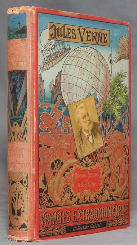
1894ref. 12400Paris, Bibliothèque d'éducation et de récréation - Les Voyages extraordinaires, J. Hetzel et Cie, 1894. Grand in-8 de [4]-420-[2]-8 (catalogue HF) pages, cartonnage polychrome d'éditeur "au portrait collé", dos au phare, second plat type Lenègre "e", tranches dorées. Auréole au coin supérieur des 80 dernières pages, mors, coiffes et coins inférieurs frottés, coins supérieurs un peu tapés, rousseurs se limitant aux premiers feuillets. Lenègre relieur.
1923ref. 23423Paris A.Paul, C.Vigier, Editions coloniales 1923 in-12 broché 1 volume, broché crème (paperback) in-octavo Editeur (22 x 14 cm), dos et couverture imprimés et illustrés en noir, 3 toute petites taches de café au niveau du titre sur la 1ère de couverture (mais vraiment trés légères), toutes tranches lisses, Rarissime recueil de poèmes illustrés de 26 planches-photographiques hors-texte à la sépia et de 14 photographies in-texte en noir. Imprimées sur beau papier, tirées des collections du photographe Dieulefils, 186 pages, 1923 Paris, A.Paul, C.Vigier, Editions coloniales et chez l'auteur, à Malestroit (Morbihan) Editeur,
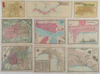
1870ref. 221021Japan. Circa1870s - 1890s. Collection of nine handcoloured copper engraving maps: 大日本全圖. Greater Japan map. 11.5 x 31cm 京都全圖. Kyōto map. 11.5 x 16cm 大阪全圖. Ōsaka map.11.8 x 16cm 大阪市街之圖. Ōsaka city map. 18 x 21.3cm 箱館市街之圖. Hakodate city map. 18 x 21.5cm 長﨑市街之圖. Nagasaki city map. 18 x 22cm 兵庫神戸両港市街之圖. Hyōgo Kōbe city map. 18.1 x 21.6cm 新潟市街之圖. Niigata city map. 18 x 21.8cm 京都市街之圖. Kyōto city map. 17.3 x 21.5cm Occasional light browning on margins of a few maps but all maps in very good condition. This very attractive collection of nine hand-coloured copper engraved maps was most likely published during the early Meiji period between the 1870s and early 1880s. The first three maps depicting Japan Kyoto and Osaka probably date from the early 1870s. On the Osaka map the site of Osaka Castle is still identified simply as a castle while the map of Japan uses Edo-period regional names such as Tosa rather than Kochi Prefecture. The remaining six maps appear to be slightly later probably dating from the early 1880s. On one of these Osaka Castle is identified as military headquarters reflecting the military use of the site during the Meiji period. The map of Kobe also includes an inset railway timetable for services between Kyoto and Kobe. The railway linking the two cities opened in 1877 providing a further indication of the map’s date. The maps are delicately drawn and contain minute details including town names and the locations of numerous public and commercial facilities. Maps of the treaty ports of Hakodate Niigata Nagasaki and Kobe are particularly uncommon. The Hakodate map features attractive illustrations of a Western-style sailing ship and steamship while the Kobe map shows the foreign concession and a cemetery for foreign residents. . unknown
1688ref. 31082Amsterdam, (ca. 1688). 49,5x57 cm. Kobberstukket kort over Slesvig og Sønderjylland i original håndkolorereing. Med 2 dekorative kartoucher med putti og våbenskjold. Et meget lille hul i kystlinie øverst, repareret. Lille revnedannelse i foldningen øverst.
1787ref. 56969Kiöbenhavn, Thiele, 1787. 4to. Originale blåmarmorerede omslag. Stempel på titelbladet. 16 pp., 4 kobberstukne plancher (3 foldede med landtoninger samt et kort). Rent velbevaret eksemplar på skrivepapir.
1645ref. 25260(Amsterdam, 1645 or later). 39,2x50 cm. Fine engraved map over Huntingdon, broad margins, fine orig. handcolouring. Clean. Large cartouche with dogs and huntingscenes. Map decorated with many large coats of arms.
1770ref. 16527Smukt kobberstukket, helkoloreret Islandskort. 31 x 38,5 cm. Lidt tæt beskåret og fint reparert i marginer. Beskæringen berører på få steder øverst og nederst pladeranden med mindre en 1 mmm.
ref. 39180No place and date (probably Denmark, late 18th century). Hand painted map in ink and water colour. 26,5 x 41 cm. Silver frame. Overall slightly foxed.
1758ref. 39179No place and date. (probably Denmark late 18th century). Handpainted map in ink and watercolour. 25 x 41 cm. In silver frame. Slightly foxed overall.
1905ref. 57772London, Edward Stanford, 1905. (95 x 95,5 cm.). A large lithographed map of Brazil, lithographed in colours, original linen-backed and folded in 35 sections. Folded in the original cloth-case with the original printed title-label preserved. A fine copy.
1890ref. 35718(Stockholm, ca. 1890). Folio-oblong. Orig. hldrbd. med rygforgyldning. Ryg med lidt skrammer. Med et oversigtskort og et blad med Teckenförklaring samt alle 66 farvelitograferede kort, som opmålt indtil udgivelse (ca. 1890).
1691ref. 43500Amsterdam, Huguetan & Mortier, 1691. 56x85 cm. Large engraved map of Terra Sancta with original colours in outline. With two large engraved cartouches. Small repairs to lower part of centerfold.
1825Weimar, in Verlage des Geographischen Instituts, 1825-28. Folio. Each 49x60 cm. 5 steel-engraved maps depicting the 5 parts of Prussia. All Handcoloured in outline. Cont. blank wrappers, wrappers partly lost. All maps with broad margins with use and tears, one tear reaching engraved surface. Some soiling. The last 2 maps dampstained in right corners.
1688Amsterdam, (ca. 1688). 49,5x57 cm. Kobberstukket kort over Slesvig og Sønderjylland i original håndkolorereing. Med 2 dekorative kartoucher med putti og våbenskjold. Et meget lille hul i kystlinie øverst, repareret. Lille revnedannelse i foldningen øverst.
1787Kiöbenhavn, Thiele, 1787. 4to. Originale blåmarmorerede omslag. Stempel på titelbladet. 16 pp., 4 kobberstukne plancher (3 foldede med landtoninger samt et kort). Rent velbevaret eksemplar på skrivepapir.
1645(Amsterdam, 1645 or later). 39,2x50 cm. Fine engraved map over Huntingdon, broad margins, fine orig. handcolouring. Clean. Large cartouche with dogs and huntingscenes. Map decorated with many large coats of arms.
1770Smukt kobberstukket, helkoloreret Islandskort. 31 x 38,5 cm. Lidt tæt beskåret og fint reparert i marginer. Beskæringen berører på få steder øverst og nederst pladeranden med mindre en 1 mmm.
No place and date (probably Denmark, late 18th century). Hand painted map in ink and water colour. 26,5 x 41 cm. Silver frame. Overall slightly foxed.
1758No place and date. (probably Denmark late 18th century). Handpainted map in ink and watercolour. 25 x 41 cm. In silver frame. Slightly foxed overall.
1905London, Edward Stanford, 1905. (95 x 95,5 cm.). A large lithographed map of Brazil, lithographed in colours, original linen-backed and folded in 35 sections. Folded in the original cloth-case with the original printed title-label preserved. A fine copy.
1702Frankfurt, Johann Philipp Andreae, 1702. 8vo. (18 x 11 cm.). Contemp. full calf. Richly gilt spine. Raised bands. Spine-ends repaired. (2),373,(59) pp. With 50 (of 64) fine half-page handcoloured maps (ca 65 x 78 mm), each with text. Maps ahead of the text. Added 6 maps in facsimile. Title-page in facsimile. Internally clean.
1890(Stockholm, ca. 1890). Folio-oblong. Orig. hldrbd. med rygforgyldning. Ryg med lidt skrammer. Med et oversigtskort og et blad med Teckenförklaring samt alle 66 farvelitograferede kort, som opmålt indtil udgivelse (ca. 1890).
1691Amsterdam, Huguetan & Mortier, 1691. 56x85 cm. Large engraved map of Terra Sancta with original colours in outline. With two large engraved cartouches. Small repairs to lower part of centerfold.
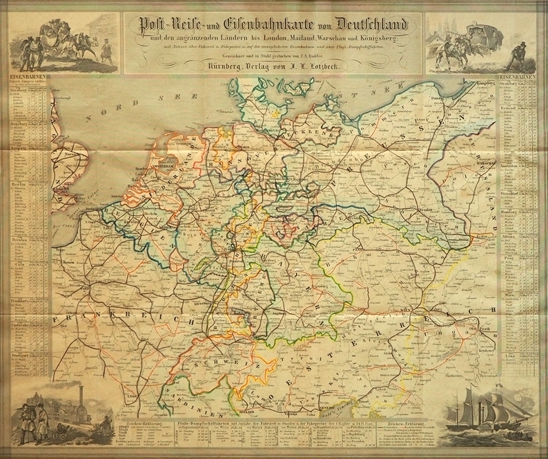
1847ref. 88384Nürnberg, J. L. Lotzbeck [Johann Ludwig Lotzbeck], 1847. Mehrfach gefaltet. grenzkolorierte Stahlstichkarte, [Maßstab ca. 1:3.800.000]. Karte 39,5 x 47 cm, Blattgröße 41 x 50 cm.
1704Pianta di Roma antica, orientata con il nord a sinistra."A proiezione obliqua; orografica. Veduta a volo d'uccello con la raffigurazione dei soli edifici e monumenti pubblici principali, rappresentati in alzato" (cfr. Scaccia Scarafoni p. 36).La mappa deriva da quella di Johannes Blaeu del 1663, della quale è una perfetta riedizione, non derivante dalla stessa lastra: "Quella del Mortier non è dunque un ristampa della precedente del 1663, come si legge in qualche repertorio, ma una perfetta riedizione […] lo dimostrano alcune varianti, il titolo in latino al centro in alto rialzato per far posto alla sottostante traduzione in francese, i toponimi interamente riscritti e leggermente più grandi dell'originale, soprattutto la scomparsa del ricco stemma del nobile Simone van Hoorn e del cartiglio con la dedica allo stesso, a firma del Blaeu" (cfr. Caldana, p. 98).Opera tratta dal terzo volume del Nouveau Theatre de l’Italie.Acquaforte, con margini, in perfetto stato di conservazione. Map of ancient Rome, oriented with the north to the left."A proiezione obliqua; orografica. Veduta a volo d'uccello con la raffigurazione dei soli edifici e monumenti pubblici principali, rappresentati in alzato" (cfr. Scaccia Scarafoni p. 36).The map derives from Johannes Blaeu's map of 1663, of which it is a perfect re-edition, nor derived from the same plate: "Mortier's map is therefore not a reprint of the previous one of 1663, as we read in some repertoire, but a perfect re-edition [...] this is demonstrated by some variations, the Latin title in the center at the top raised to make way for the underlying French translation, the place names entirely rewritten and slightly larger than the original, especially the disappearance of the coat of arms of the noble Simone van Hoorn and the cartouche with the dedication signed by Blaeu" (cf. Caldana, p. 98).Work taken from the third volume of the Nouveau Theatre de l'Italie.Etching, with margins, in perfect condition. Caldana, "Roma Antica", 2013, p. 98, n. I.45; Scaccia Scarafoni, "Le Piante di Roma", n. 36.