5 228 résultats
2017réf. Manohar-9780415786317Routledge 2017. Hardcover. New. Routledge hardcover
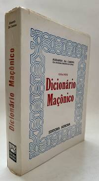
1990réf. 105525Rio de Janeiro: Editora Aurora 1990. Paperback. Very good ; binding is tight and pages clean; some mild wear to edges of wraps and light sunning to spine. Octavo with white and red oversized self-wraps; 413 pages; 22 cm. Uncommon. Dictionaries Freemasonry Freemasonry Dictionaries Portuguese Freimaurerei Wörterbuch Somewhat heavy item. Qualifies as 3 lbs when packed. Additional shipping fees may be needed for expedited priority or international orders. Please inquire. Editora Aurora paperback
1980réf. KOS00600224Taisho Nichinichi Shimbun 1980. Soft Cover. Fine. KOS00600224 Taisho Nichinichi Shimbun paperback
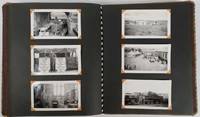
réf. 177650154 black and white snapshots held in place with photograph corners in a patterned fabric covered photograph album. Sizes of the photographs vary from 5 x7.5cm to 8.5 x 12.5cm. Black and white folding map of Burma 34.7 x 24cm loosely inserted two insets on the map show an elephant carrying teak a mahout on his back and a small map showing Burma's location within the region. Although the photographs are not individually captioned the album is divided into sections titled in white ink. Some blank leaves towards the rear of the album a separate section of 10 photographs titled "Burma & China" fills the last leaves. Six photographs are evenly browned all others are in excellent condition. A very interesting photograph album in excellent condition. A fascinating photographic record of events on the crucial Burma Road in southwestern China during and immediately after the Pacific War. An inscription on the final leaf gives the name John Barry Williams and the date 6/23/42 to 1/15/46. The Burma Road was constructed in 1936-1937 mainly to enable the allies to send material to China which was then at war with Japan. After the occupation of Burma by Japan in 1942 the flow of goods was cut until 1945 when in the last months of the war allied troops reconnected the transport corridor from Burma to China. Meanwhile war materiel continued to be transported by plane between Yunnan in China and India over the section of eastern Himalayas known as 'The Hump'. The owner of this album appears to have been a US serviceman stationed at Tsuyung Airfield in the Chinese province of Yunnan - the main transport hub at the Chinese end of the Hump route. The first photos in the album show scenes of the Burma Road and the Salween River on the border of Yunnan and Burma. There are a number of fine black-and-white photos of everyday life in the area including a village street a local salt mine a farmer ploughing with water buffaloes a street scene in Tsyuyung town women and children repairing the road and a train of pack ponies taking goods to market along the Burma Road in China. There are also images of a serviceman named Washburn holding up a captured Japanese flag. The following series of photos is labelled '780 Engineer Petroleum Distribution Co. Pipeline India-Burma-China 1944 and 1945' and shows scenes of the contruction of this vital fuel link with photos shot in India in the jungles of Burma and in southwestern China. The photos give a vivid image of the magnitude of the construction task showing teams camping out in rugged terrain and crossing rivers on makeshift bridges. A final group of photos labelled 'Burma and China' includes shots of a parachute drop from a plane and an image of allied soldiers with local villagers. A small map of Burma and Tibet published in 1948 has been loosely inserted in the front of the volume. . unknown
2011réf. 91600México: Tumbona Ediciones 2011. Paperback. Fine sealed in original shinkwrap. White b&w and color illus octavo 125 pages likely b&w illustrations; 24 cm. In Spanish. Scarce Series: Coleccion Anómalos. Language Creative writing Shorthand Typewriters. Typewriter Art. Concrete poetry. Tumbona Ediciones paperback
1965réf. 89986Guatemala: Editorial Universitaria 1965. First edition. Paperback. Moderate to heavy bump to bottom outer corner. Very mild rubbing to head and foot of spine. Else pages clean and binding tight. Overall very good to near fine. Paperback quarto with gray and creme spine. 105 pages illustrations some color 21 cm. In Spanish. Scarce. Contents: El gavilán y el quebrantahuesos.-- Barriletes.-- Cachobajo.-- El remolino.-- Cabeza que no siento. Editorial Universitaria paperback
1991réf. 20179Zamora Michoacán Mexico: Colegio de Michoacán; Gobierno del Estado de Michoacán 1991. Paperback. Fine; an unread tight. clean and very crisp copy. Folio in glossy color illus paper wraps; 439 p.: ill. many in color; bibliographical references p. 433-437 and index; 34 cm. In Spanish. Uncommon. Only 3000 copies printed. // Churches of Mexico; Christian art and symbolism -- Mexico -- Morelia. Catedral de Morelia. Morelia Mexico -- Buildings structures etc. Colegio de Michoacán; Gobierno del Estado de Michoacán paperback
réf. 24608‘PUBLISHED BY ALFRED H. MAYHEW / At the Sign of “The Smithy” 56 Charing Cross Road London W.C.2. / 1926. / Printed in Great Britain by R. Stockwell Baden Place Crosby Row S.E.1.’. Five copies listed on JISC. Now scarce. 8pp 16mo. Stitched pamphlet on good wove paper. In fair condition lightly aged with small closed tear at head of first leaf. First two leaves with light crease. Enfolded in ‘wallet’ of the same paper repeating the title on the front differently positioned and also giving the price as sixpence. The poem covering pp.2-7 is in small print and the first stanza reads: ‘I bind upon myself to-day / The Strength of the Holy Trinity: / That mighty Breastplate be my Stay! / I here invoke . . . I here confess . . . / The Three in One the One in Three! / Creator! Judge! Wilt Thou not bless’ On the final page above Mayhew’s device and the slug is a fifteen-line note by ‘A. H. M.’ including the following: ‘The foregoing adaptation is based upon prose translations by Dr. Todd and Dr. Whitley Stokes and a comparison with the Ancient Irish Text. Though made for the “Wayland-Dietrich Saga” it is felt that a separate impression may not be unacceptable.’ Nearly a century later there is still a bookshop on the same site one of the few to survive the decline of the Charing Cross Road. ‘PUBLISHED BY ALFRED H. MAYHEW / At the Sign of “The Smithy,” 56, Charing Cross Road, London, W.C.2. / 1926. / Printed in unknown
réf. 0946489378.Gpaperback. Good. Access codes and supplements are not guaranteed with used items. May be an ex-library book. paperback
réf. 1019687355.Ghardcover. Good. Access codes and supplements are not guaranteed with used items. May be an ex-library book. hardcover
réf. 0935480307.Gpaperback. Good. Access codes and supplements are not guaranteed with used items. May be an ex-library book. paperback
réf. 21785606-nnew. unknown
réf. 0916221008.Gpaperback. Good. Access codes and supplements are not guaranteed with used items. May be an ex-library book. paperback
réf. 6202459824.Gpaperback. Good. Access codes and supplements are not guaranteed with used items. May be an ex-library book. paperback
réf. 18823315like new. unknown
réf. 1249023408.Gpaperback. Good. Access codes and supplements are not guaranteed with used items. May be an ex-library book. paperback
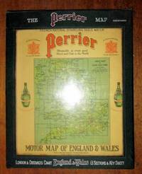
1922réf. 198554United Kingdom: George Philip & Son for Perrier 1922. Book. Very Good. Hardcover. a very good set of sectional coloured maps on an 8 miles to the inch scale in original case undated but around 1920-1923 as the Road lettering and numbering system A1 A40 etc are not here used and earlier than 1920 copies were backed onto linen fourteen maps distance card Index sheet all printed on card and with linen index taps to top edge lacking tab for Card Six Index card with Perrier advertising and reference to Royal Warrant of George V housed in a very good original wooden sided case lettered silver and red on green cloth plastic front to case revealing maps behind two press fasteners to rear flap a very well preserved set. George Philip & Son for Perrier Hardcover
réf. lom-ZLO000741Familia de Marti Ezequiel Martinez Estrada La Habana. In Spanish. Please feel free to contact us for a detailed description of the copies available. SKUZLO000741 unknown
réf. 128736151X.Gpaperback. Good. Access codes and supplements are not guaranteed with used items. May be an ex-library book. paperback
réf. 9681209095.Gpaperback. Good. Access codes and supplements are not guaranteed with used items. May be an ex-library book. paperback
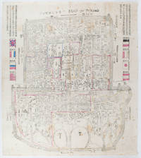
1900réf. 169765Circa1900. Large illustrated map of Beijing showing the city in the period following the invasion of the military forces of the Eight National Alliance old folds scale not given. Some scattered light foxing particularly at edges short closed tear at fold lower edge neat non acidic tape repair short section upper edge wear along folds and a couple of small unobtrusive holes with minor image loss. Blocks of text in traditional Chinese right and left upper sections stating each nation's occupied zone Japanese text title accompanies the English title along the upper section of the map. 63.7 x 56.9cm. Very good overall. A rare and significant large Japanese woodblock map of Peking Beijing issued just after the suppression of the Boxer Rebellion. Centred on the Forbidden City the map depicts Peking following the multinational suppression of the Boxer Rebellion or Yihetuan Movement of 1900. The map was issued to illustrate the areas of occupation associated with each of the powers in the Eight Nation Alliance. The map gives measurements of the city walls detailed names of streets and buildings and the boundaries of the inner and outer city including the forbidden city are shown with demarcation lines in pink yellow and blue. The hand coloured eight national flags of the occupation powers are featured at the right and left. This map is essentially a later edition of 京城内外首善全圖 a map of Beijing issued by the Qing for administrative purposes in the mid-19th century. The Japanese seized the wood blocks during the suppression of the Rebellion and subsequently pulled new impressions overprinting them additional details including flags and demarcations of areas of the city held by members of the Alliance. Versions are known in French German Japanese and as with the present example English. An attractive map of great historical interest. . unknown
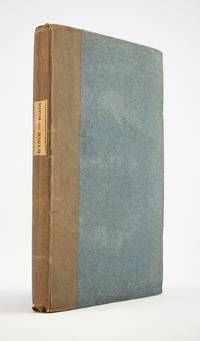
1823réf. ST20595London: Longman Hurst Rees Orme and Brown 1823. Seventh Edition. 237 x 145. 9 3/8 x 5 3/4". 3 p.l. vii 1 viii 1 6-236 pp. Publisher's blue paper boards and brown paper backstrip original printed paper label EDGES UNTRIMMED AND MOSTLY UNOPENED. A Large Paper Copy. Just the faintest evidence of foxing at very beginning and very end corners with slight wear as always superficial chafing to covers but AN EXCEPTIONALLY FINE COPY the binding remarkably clean and with no significant signs of use and the wide-margined text unusually fresh and nearly as white as snow. In its original boards untrimmed and partly unopened this is a wonderful contemporary copy of an important later edition of the magnum opus of a man whose name came to be synonymous with road improvement. DNB tells us that Scottish-born John Loudon McAdam 1756-1836 was "the first systematic builder and administrator of roads in Britain since Roman times" and his impact was so great that his name lives on to the present day in connection with paved surfaces. The use of "macadam" or "macadamized" to mean a good road surface began in the 1820s and continued through the invention of the automobile when dusty roads began to be improved with tar. At first "tar" was combined with "macadam" producing the term "tarmacadam" when referring to these improved roads; eventually this became shortened to "tarmac" which still is broadly understood to refer to road surfaces and more specifically to airport runways. Our author first published "Remarks on the Present System of Road Making" in 1816 to deliver his suggestions for an improved paving method following his extensive survey of the roads of Britain. His system--in which roads were built with a cambered surface for drainage using layers of consistent sizes of stones and gravel--soon caught on both within Britain and abroad. The present seventh edition features a variety of new material much of which deals with McAdam's efforts to encourage legislation for improving roads; this includes a new preface and advertisement as well as the "Minutes of Evidence" given by witnesses regarding turnpike improvement from March to May 1819 and the report of the Select Committee of the House of Commons on McAdam's system from June 1823. As evidenced by its appearance in multiple printings McAdam's "Remarks" was a widely used book but our remarkably well-preserved copy in its publisher's boards--obviously and decidedly--was not. Longman, Hurst, Rees, Orme, and Brown unknown
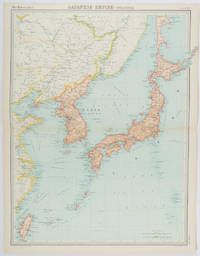
1922réf. 215880Edinburgh.: John Bartholomew & Son Ltd. 1922. Large double page map 54.2 x 43 cms map original fold some edge toning and to the fold but in very good condition. Large map prepared as plate 65 for “The Times Survey Atlas of the World” in 1922 and was prepared at the Edinburgh Geographical Institute under the direction of J G Bartholomew. The map shows Japan's territory inclusive of Korea southern Sakhalin and Taiwan. . John Bartholomew & Son Ltd. unknown
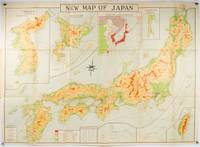
1935réf. 214827Tokyo.: Nihon-Kenkyusha. 1935. Large folding colour map of Japan 74.3 x 10⁵ cms; folding into printed card covers 27 x 19.5 cms: 9 insets: Chosen Korea; Hokkaido; Chisima Islands; General Map of Japan and Manchuokuo; Karafuto Saghalien; Okinawa Loochoo; Taiwan Formosa; Micronesia; Ogasawara; Hajijoshima; the covers a litle worn and marked and the sheet slightly toned but the map is in very bright clean condition. Scarce World War II era map of Japan including Korea published in English by Kenkyusha. Founded in 1907 it had a history of publishing for students of English and the English market. An attractively composed map in remarkbable condition; with the insets circled around the islands of Japan heights marked in graduations from green to red and showing provinces railways roads steamer routes Buddhist and Shinto Temples. . Nihon-Kenkyusha. unknown
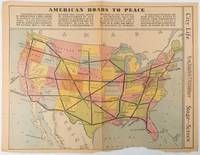
1938réf. 215547Los Angeles.: Los Angeles Examiner. Sunday 1 May1938. Printed colour pictorial map 33 x 48 cms; 41.8 x 54.5 cms sheet central fold sheet toned corners chipped with some loss to the bottom border and at the central fold in good condition; and on the verso "Movie-Go-Round" by Louella O. Parsons black and white photos and advertisements. Pictorial map printed for the weekend supplement of the Randolph Hearst owned newspaper the Los Angeles Examiner. The map-maker and artist Howard Burke had also worked for the San Francisco Examiner and was known for pictorial maps many with a persuasive or rhetorical edge and as here were designed to shore up American patriotism and defences against a wider world in the increasingly turbulent pre-war 1930s. The caption to this map outlines a multi-billion dollar 25 year proposal by Congressman J. Buell Snyder for a network of coast to coast transcontinental highways "in case of an attack by a foreign power at any point along the border". Buell Snyder earned the soubriquet "the father of superhighways" and during the War he was assigned to a Congressional Committee in charge of appropriations for the War Department. Scarce. . Los Angeles Examiner. unknown