5 290 résultats
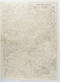
1572réf. 172829大阪. Osaka.: 大阪毎日新聞社. Osaka Mainichi Shinbunsha. 昭和 13 1938. Black and white map folded showing Hankow one of the three cities which merged to become Wuhan 54.5 x 49cm scale 1:2000000. Some light browning tiny closed tear upper margin neatly repaired with conservation standard tape. Good copy. This Hankow/Hankou War Situation Map is a supplement map of Osaka Mainichi Newspaper on 25 August 1938. The two inset maps show the region around Nanjing and Hong Kong. It gives detailed place names of Hankow area. . 大阪毎日新聞社. [Osaka Mainichi Shinbunsha]. unknown
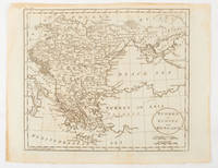
1816réf. 175252Philadelphia.: Carey Mathew and Warner Benjamin. 1816. Engraved map 19 x 22.3 cm original folds some offsetting to the map marginal browning and staining small archival repairs to the outer margin but in good condition. Fine map Plate 19 prepared for Carey and Benjamin's "General Atlas.". . (Carey, Mathew and Warner, Benjamin). unknown
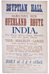
réf. 99252London Printed by S. Golbourn February 1876. . Broadsheet 51.25 x 31.4 cm printed in blue and tan horizontal centre fold short split short splits to head a good example. Rare broadsheet advertising an exhibition at the Egyptian Hall. The Egyptian Hall was a leading venue for exhibitions featuring original artwork and relics. London, Printed by S. Golbourn, February 1876. unknown
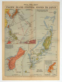
1944réf. 208880Chicago.: Chicago Daily Tribune. 28 September1944. Colour pictorial map on a single newspaper leaf archivally laid down on linen 50 x 39.2 cms; 59.3 x 43.3 cms sheet including captions faint toning to fold lines very good condition. Vivid colour maps of the Palau Islands Guam and Saipan in the Marianas and an inset location map published in the "Chicago Daily Tribune" in September 1944 months after the landing of US and Allied Forces in the offensive against the Japanese during the Pacific War. . Chicago Daily Tribune. unknown
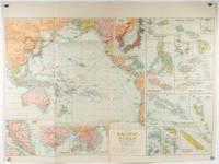
1930réf. 205997Sydney: H.E.C. Robinson. Circa1930s. Printed colour maps in all 65.5 x 99cm the main map roughly 50 x 65 cm on a single sheet 76 x 101.3 cms; a little carelessly folded decorative blue title cover a little dusty and a few fold splits and edgewear but in good condition. The exceptional feature of this map are the twenty six large scale inset maps of Pacific islands including: Malay States Singapore Hong Kong these at lower left Japan Philippine Islands Hawaiian Islands Fiji Solomon Islands Western and Eastern Samoa Tahiti Saipan New Caledonia and Dependencies and many others. The main map of the Pacific Ocean stretches from Southeast Asia including all of Australia and New Zealand the west coast of the Americas the Kamchatka Peninsula Manchukuo Manchuria and most of China. Korea and Taiwan are marked as Japanese Territory. Possessions of Britain France the Netherlands and the United States are highlighted. An incredibly rich source of information on the Pacific theatre during the years leading up to World War II. From the Sydney publisher H.E.C. Robinson the firm founded in 1895 by Herbert Robinson 1857-1933 a founder of the Royal Geographical Society of Australasia. . H.E.C. Robinson. unknown
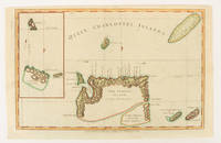
1784réf. 174895London.: Alexander Hogg at the King's Arms. circa1784. Engraved map on laid paper 21.4 x 33.7 cm inset of Gower's Simson's and Carteret's Island early outline hand colour trimmed to the plate mark at the top edge three small edge tears affecting the upper margin only slight paper toning but a most attractive map in very good condition. Fine impression of the Queen Charlotte's Islands Solomon Islands. It features the Swallow's track the ship's route taken by Captain Philip Carteret in 1767 the British naval officer and explorer who participated in two of the Royal Navy's circumnavigation expeditions in 1764–66 and 1766–69. . Alexander Hogg at the King's Arms. unknown
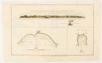
1784réf. 174896London.: Alexander Hogg at the King's Arms. circa1784. Engraved map in triptych on laid paper 20.1 x 32.7 cm three insets: cross section of the north side of Queen Charlotte's Islands Solomon Islands with detail of a volcano "6 leagues North"; Swallow's Bay Harbour; and Byron's Harbour early hand colour trimmed to the plate mark at the top edge neat sealed tear affecting the publisher's caption slight edge wear and paper toning but a most attractive map in very good condition. Attractive engraving of the Queen Charlotte's Islands Solomon Islands. The Islands were named for the consort of King George III by Philip Carteret the British naval officer and explorer who participated in two of the Royal Navy's circumnavigation expeditions in 1764–66 and 1766–69. His ship the Swallow gave her name to the Bay and Carteret's commanding officer on the first of his voyages John Byron to the Harbour depicted in this most attractive early chart. . Alexander Hogg at the King's Arms. unknown
réf. 13821Sans lieu, Chemins de fer Paris-Lyon-Méditerranée, sans date. Plaquette in-12 brochée de 31 pages, couverture illustrée.
réf. 201602773Paris, MON JOURNAL - aventures et voyages, s.d. ; in-12, 130 pp., broché, couverture illustr. Bon état -.
réf. 201602772Paris, MON JOURNAL - aventures et voyages, s.d. ; in-12, 130 pp., broché, couverture illustr. Bon état -.
réf. 201602774Paris, MON JOURNAL - aventures et voyages, s.d. ; in-12, 130 pp., broché, couverture illustr. Bon état -.
réf. 201102848Paris, MON JOURNAL - aventures et voyages, s.d. ; in-12, 130 pp., broché, couverture illustr. Bon état -.
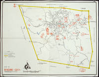
1960réf. 206510circa1960. Printed pictorial map 44.8 x 58 cm 46.7 x 60.3 cms sheet original folds a little wear but in very good condition. Attractive 1960s tourist map of Baguio city when it was the "Summer Capital" of the Philippines. Tourist attractions are shown pictorially in red blue triangles denote wood carving shops the city boundaries outlined in yellow sealed and unsealed roads are also shown. . unknown
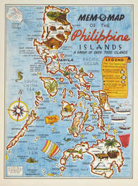
1945réf. 204557U.S.A.: Mem-O-Map Co. 1945. Colour pictographic / pictorial map 32.1 x 23.8 cms; 35.4 x 26.6 cms sheet very good condition. Rare pictorial map published in 1945 by John G. Drury aTechnical Officer who served with the 214th Ordnance Battalion to mark the end of World War II as souvenirs for the military. Military personnel could fill in banners "came in on good ship." and "departed on good ship." their name organisation and "Line of Advance or movement" blank in this example. Pictographs mark various memorable spots and wildlife including larger-than-life insects. A "Terrible Tillie Typhoon" looms over the coast at Luzon. Drury published a series of five maps: Philippines and Okinawa in 1945; Japan and Korea Oahu and Europe in 1946. They are all scarce. “These almost whimsical maps are designed to support the creation of personalised geographies. At a time when digital mapping is beginning to experiment with the creation of personalised content that would render the same map in different ways for different users Mem-O-Maps demonstrate the principle in action." Kenneth Field ICA Commission on Map Design. . Mem-O-Map Co. unknown
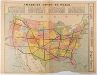
1938réf. 215547Los Angeles.: Los Angeles Examiner. Sunday 1 May1938. Printed colour pictorial map 33 x 48 cms; 41.8 x 54.5 cms sheet central fold sheet toned corners chipped with some loss to the bottom border and at the central fold in good condition; and on the verso "Movie-Go-Round" by Louella O. Parsons black and white photos and advertisements. Pictorial map printed for the weekend supplement of the Randolph Hearst owned newspaper the Los Angeles Examiner. The map-maker and artist Howard Burke had also worked for the San Francisco Examiner and was known for pictorial maps many with a persuasive or rhetorical edge and as here were designed to shore up American patriotism and defences against a wider world in the increasingly turbulent pre-war 1930s. The caption to this map outlines a multi-billion dollar 25 year proposal by Congressman J. Buell Snyder for a network of coast to coast transcontinental highways "in case of an attack by a foreign power at any point along the border". Buell Snyder earned the soubriquet "the father of superhighways" and during the War he was assigned to a Congressional Committee in charge of appropriations for the War Department. Scarce. . Los Angeles Examiner. unknown
réf. 3001Trenton: The Company; Press of the Emporium 1846. . 8vo self-wrappers side-stitched Not found in OCLC. Trenton: [The Company]; Press of the Emporium, 1846. unknown
réf. 3006Milwaukee: The Company; Daily News Book and Job Steam Printing Office 1857. . 8vo yellow wrappers front printed This is not a later printing of Library of Congress Modelski No. 440. There is no inset and the copyright is 1856 Milwaukee: [The Company]; Daily News Book and Job Steam Printing Office, 1857. unknown
réf. 2618S.l.: The Company 1930. . 8vo yellow wrappers front pictorial; back with some abrasiion. This appears to be a variant of the item with the same title in your collection. S.l.: [The Company, 1930]. unknown books
réf. 3001Trenton: The Company; Press of the Emporium 1846. . 8vo self-wrappers side-stitched Not found in OCLC. Trenton: [The Company]; Press of the Emporium, 1846. unknown books
réf. 3006Milwaukee: The Company; Daily News Book and Job Steam Printing Office 1857. . 8vo yellow wrappers front printed This is not a later printing of Library of Congress Modelski No. 440. There is no inset and the copyright is 1856 Milwaukee: [The Company]; Daily News Book and Job Steam Printing Office, 1857. unknown books
réf. 200817469Lausanne, Cristal&derib, 1988 ; in-4, 60 pp., cartonnage de l'éditeur. Eo tome 1.
réf. 200817468Lausanne, Cristal&derib, 1988 ; in-4, 60 pp., cartonnage de l'éditeur. Eo tome 1.
réf. 200817467Lausanne, Cristal&derib, 1988 ; in-4, 60 pp., cartonnage de l'éditeur. Eo tome 1.
réf. 200809789Lausanne, Cristal&derib, 1988 ; in-4, 60 pp., cartonnage de l'éditeur. Eo tome 1.
réf. 9979GRAND' ROUTE. N° 4. (Juin 1930). André Cayatte, Philippe Lamour, Eric B. Hurel, Filippo Burzio, René Laporte, Jacques Dalleas, Pierre Scize, Henri Lens,W. Gebrowsky. /// Dessin de Mayo. /// Couverture et dos défraîchis ; propre intérieurement. Rare.