SPEED, JohnBiblio.com
1,394 results
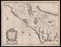
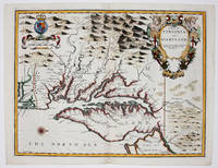
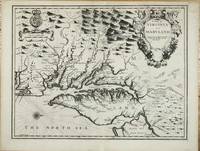
ref. 10915London: Sold by Tho:Bassett in Fleetstreet and Richard Chiswell in St. Pauls Church Yard. 1676. No binding. Good. 380 x 500 mm. with a small upper right corner margin repair otherwise in good condition. One of the maps 'relating to North America introduced into the 1676 edition of John Speed's 'Theatre of the Empire of Great Britaine' is this one of Virginia and Maryland. Augustine Herrman's landmark map of the region had been published three years earlier and bore a royal Privilege. However that did not protect its superior cartography from being poached. Here the mapmaker is more circumspect following John Smith's general outline from 1612. He draws upon the Herrman mainly for toponomy. As such it is the first printed map to utilise its improved geography although the Robert Morden and William Berry 'Map of New England .' was advertised just four days later. We should also bear in mind the possibility of Speed's 'Epitome' being issued earlier still. As such it is particularly important in representing the transition between two fundamental maps of the region. Other areas where the Herrman was used is in the depiction of the Delaware Bay and River which was omitted altogether from the Smith map and an improved delineation of the north-eastern shore of Chesapeake Bay. An independent source for the Atlantic coast of the peninsula is used. The June 1668 border settlement between Maryland and Virginia on the eastern shore is shown with the Herrman-like usage of a double line of trees. One item that did not appear on either of the progenitor maps is a brief inclusion of northern Carolina. The text on the reverse of the map is a condensed version of that found in John Ogilby's America 1671' Burden. John Speed 1552-1629 is the most famous of all the English map-makers. His two most celebrated publications are 'The Theatre of the Empire of Great Britain' covering the British Isles first published in 161112 and the 'Prospect of the Most Famous Parts of the World' first published in 1627. Speed was a tailor by profession with a great interest in history and maps. He wanted to produce an English atlas of the same high standards and quality as those published on the continent. The 'Prospect of the Most Famous Parts of the World' was published in 1627 two years before the death of Speed. Ownership of the atlas passed through various hands until sometime after 1668 when Roger Rea sold the rights to Thomas Bassett and Richard Chiswell. Bassett was a specialist in legal books and Chiswell was the publisher for the Royal Society. The final 1676 edition of the 'Prospect' includes eight further maps on seven sheets appearing for the first and only time. Baer 1949 no. 86; Burden 1996 no. 164; Morison Papenfuse Bramucci & Janson-La Palme 1983 pp. 17-19; Papenfuse & Coale 1982 pp. 16-18; Phillips 'Atlases' 488; Shirley 2004 T.Spe 1j; Skelton 1970 92; Verner 1968 pp. 170. Sold by Tho:Bassett in Fleetstreet and Richard Chiswell in St. Pauls Church Yard. 1676 unknown
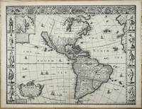
ref. 11106London: George Humble. 1627-31. No binding. Fair. FIRST ATLAS MAP TO DEPICT CALIFORNIA AS AN ISLAND. 390 x 510 mm. with a wormhole near the bottom of the centrefold repaired otherwise in good condition. ""This desirable map is the first published in an atlas to depict California as an island and an accurate east coast of North America particularly between Chesapeake Bay and Cape Cod."" Burden. It was first published in the 1627 edition of John Speed's 'Theatre of the Empire of Great Britain' the first English world atlas. For this edition the work was expanded with 'A Prospect of the Most Famous Parts of the World' which included a further twenty maps The map is engraved by the Dutchman Abraham Goos c.1590-1643 who drew on his engraving of North America from 1624 and the Henry Briggs map of 1625 to depict California as an island once more. ""He was the only Dutch cartographer to do so for some considerable time. There are five fewer placenames in California than the Briggs. However like his earlier one he includes a similar faint north-west coastline and Strait of Anian. 'Brasil' and 'Frisland' remnants from the sixteenth century make a stubborn appearance in the North Atlantic. The fledgling colonies of 'Plymouth' in New England and 'Iames Citti' in Virginia are both recognised. Decorating the whole are three attractive borders. The two sides illustrate the natives of the continent the left bears those of the north and the right those of the south. Despite the map's obvious attention to the English presence in North America none of the eight towns represented in the third are from that part. This is owing to the relative lack of any contemporary views to draw upon."" Burden. South America includes 'Bones Aeyres' founded in 1580. It is also one of the earliest maps to record Tierra del Fuego following Jacob Le Maire and Cornelis Schouten's voyage rounding Cape Horn 1615-17. John Speed 1552-1629 was a historian but his most remembered for his maps. He was like his father a tailor by trade. The 1627 edition was published by George Humble who reissued it in 1631. Provenance: Juan and Peggy Rada Collection. Burden 1996 217; Leighly 1972 pl. 4; McLaughlin & Mayo 1995 no. 3; Skelton 1970 no. 16; Tooley 1964 p. 113; Tooley 1973 pp. 302-3; Tooley 1977 pp. 4-9; Wheat 1957 pp. 36-7 & no. 39. George Humble. 1627-[31] unknown
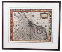
1626ref. ACH8NIO8K9DULondon: George Humble 1626. Framed. 41 x 53 cm. Engraved map with hand coloured borders probably by Pieter van den Keere 1571-after 1646. Incorporating a fine compass-rose with 32 rhumb lines and names of the wind-directions a coat of arms of France a title-cartouche a legend "A catalogue of the cities et ! villages in everie Province" and an indication of scale ca. 1:1.120.000. The map is topped by 8 hand coloured miniature profiles of major cities and bordered by hand coloured figures in local costume at the left 5 male figures and right 5 female figures. Very fine and attractive map in its first edition as published in John Speed's A Prospect of the most famous Parts of the World London 1627. The very successful map was republished in 1654 in two different states and 1674. Its decorative border incorporates profiles of Amsterdam Antwerp Ghent Middelburg Groningen Zutphen Utrecht and Atrecht and figures depicting "a Gentle woman" "a Brabanders wiffe!" "a Hollanders wiffe !" "a Fishers wiffe!" "a Contreywoman!" and their male counterparts.Slightly creased with restored tears along the head and foot of the central fold. Otherwise a very good copy.l Van der Heijden 88 first state of 4. George Humble, unknown
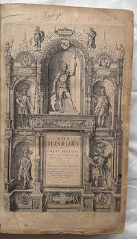
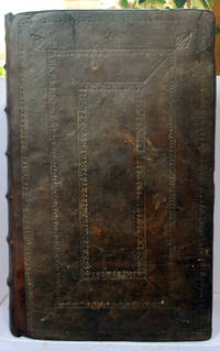
1611ref. 008199London in Popes-head alley at ye signe of ye white Horse: John Sudbury & George Humble. 1611. 1st Edition . Hardcover. Very Good. Elephant Folio - over 15 - 23" tall. SCHWEITZER Christoph wood engraver. An important source for understanding how the history of Britain was interpreted in the early Stuart period 14 years in the making! First edition 1611. In contemporary calf with gilt arabesque to center of boards neatly rebacked with portions of original spine compartments relaid corners refurbished lacks ties. Internally engraved title with 18th-century manuscript note to verso of title regarding the volume numerous woodcut illustrations of seals & coins etc. many woodcut head & tail-pieces & initial letters errata leaf at rear margins to initial leaves lightly frayed some toning and scattered spotting endpapers renewed 18th-century monogram bookplate to fpd ms ink name to tp Lizerghe 2 tp 151-786 pp 787-801 ie 802 ff 803-894 pp 2 conclusion 23 tables 1 errata a few leaves bound in the wrong order. Folio 473x287 mm. STC 23045. Thomson - Illustrations of the History of GB XCIII The pagination is continued from The Theatre of the Empire of Great Britaine STC23041. John Sudbury & George Humble. hardcover
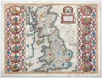
1676ref. 141841London: Basset and Chiswell 1676. Highly decorative map of the Saxon Heptarchy is from the 1676 edition of John Speed's famous atlas of 1610-12 "The Theatre of the Empire of Great Britain" published in London by Bassett and Chiswell. The most striking features of the map are the borders that flank the main body of the map. On one side they graphically portray and illustrate the seven ancient Saxon kingdoms together with their kings at the time of their own respective conversions to Christianity. The opposite side depicts the seven Saxon kingdoms with their respective kings when first established. Shields of the kingdoms a compass rose and a delightful title cartouche further enhance and embellish this most wonderful and interesting map. Copperplate engraving with hand colour. Plate mark size: 38.5 x 51. cm. Very good condition. Nicolson; The Counties of Great Britain A Tudor Atlas by John Speed p29. unknown
1676ref. 15098London: Thomas Bassett and Richard Chiswell 1676. 380 by 505mm. 15 by 20 inches. Sheet size 408 by 530mm 19 x 21 inches. Engraved map with text on verso. A fine and attractive map of the Carolina colony. Publishers Thomas Bassett and Richard Chiswell republished English cartographer John Speed's 1552-1629 popular 1611 atlas "The Theatre of the Empire of Great Britain" in 1676. As a supplement they included new section "A Prospect of the most Famous parts of the World" which contained maps engraved by Francis Lamb of the English colonies of New England and New York Virginia and Maryland Carolina and Florida and Jamaica and Barbados. This map depicts the Carolina colony in 1676 drawing from the Lord Proprietor's Map by royal geographer John Ogilby and the explorations of John Lederer fl. 1670-1675. The map orients the West to the top and depicts the coastline from Cape Charles at the mouth of the Chesapeake Bay to the north and St Augustine Florida to the south. Looking inland the Appalachian Mountains marked as "Apalathean Mountains" cut across the top right section of the map. The present map features a cartouche where the Ogilby publication had an inset map of the Ashley and Cooper Rivers. This map is one of the first to name Charleston "Charles Town" on the banks of the Ashley River. The map correctly identifies the town on the south bank of the Ashley River whereas Speed's smaller format map of Carolina incorrectly places the town on the north banks of the river. King Charles II granted eight Lord Proprietors land in North America that extended between 31 and 36 degrees latitude later extended to 29 degrees. Lederer was a German explorer who travelled West from the East coast of Virginia in hopes of finding the Pacific and the "Sea of China" with its associated riches. He never did reach the Pacific - unsurprisingly - but his personal records of his travels influenced contemporary maps. His description of the "Arenosa Desert" reflects Lederer's memory of crossing the Carolina pine barrens in the blistering summer heat. The "Great Lake" is likely the Catawba flooded which he mistook as permanent. In total Lederer traipsed across Virginia and the Eastern coast three times making it as far as the Blue Ridge mountains. Lederer's discoveries are recorded in Sir William Talbot's translation of the explorer's account from Latin to English and published in London in 1672 as "The Discoveries of John Lederer in three several Marches from Virginia To the West of Carolina." On the verso the text describes Lederer's journeys and discoveries. Burden 457 Cumming 77 Thomas Bassett and Richard Chiswell, unknown
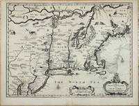
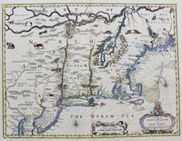
ref. 10914London: Sold by Tho:Bassett in Fleetstreet and Richard Chiswell in St. Pauls Church Yard. 1676. No binding. Very Good. 380 x 505 mm. in good condition. This fine map of New England was published at a important period of its history. It is from the most prestigious English world atlas of the seventeenth century by John Speed 1552-1629. Speed is the most famous of all the English map-makers. His two most celebrated publications are 'The Theatre of the Empire of Great Britain' covering the British Isles first published in 161112 and the 'Prospect of the Most Famous Parts of the World' first published in 1627. Speed was a tailor by profession with a great interest in history and maps. He wanted to produce an English atlas of the same high standards and quality as those published on the continent. The 'Prospect of the Most Famous Parts of the World' was published in 1627 two years before the death of Speed. Ownership of the atlas passed through various hands until sometime after 1668 when Roger Rea sold the rights to Thomas Bassett and Richard Chiswell. Bassett was a specialist in legal books and Chiswell was the publisher for the Royal Society. The final 1676 edition of the 'Prospect' includes eight further maps on seven sheets appearing for the first and only time four of these are of the 'Kings dominions abroad' the American colonies: New England Virginia and Maryland Carolina Jamaica and Barbados. The cartography of New England is drawn from the Joannes Janssonius 'BELGII NOVI .' 1651. In this example though the cartographer eliminates the south-westerly regions of the map as the intention was to provide a more detailed map of the Virginia and Maryland area. In fact it is most closely derived from the Nicolaas Jansz. Visscher version published c.1651. 'This is particularly noticeable when studying the decorative fauna depicted and the additional placenames that Visscher introduced such as Zuyder Zee south of Cape Cod here translated to South Sea. The only major cartographic alteration is the narrowing of the Delaware peninsula utilising the Augustine Herrman map 167374. Most of the differences reflect the anglicising of the map; one of the more notable additions is Boston. This is one of the first maps to depict the English pre-eminence in the region. The text on the reverse of the map describes the region although examples are known without it.' Burden. Burden 2007 455; McCorkle 2001 676.6; Phillips 'Atlases' 488; Shirley 2004 T.Spe 1j; Skelton 1970 92; Stokes 1915-28 I p. 148 & II p. 96 n.36. Sold by Tho:Bassett in Fleetstreet and Richard Chiswell in St. Pauls Church Yard. 1676 unknown
1676ref. M8290London. : Tho: Basset; Richard Chiswell c. 1676. Very Good. Notes: A significant map of the British colonies in North America covering the east coast from Maryland and New Jersey northward through New York and New England to the French possessions in Canada. It depicts the territories acquired by the British with the capture of New Amsterdam in 1664 which changed European influence in the colonies from the Dutch to the English. It is the first appearance of name Boston and the first map to use the term New York for both Manhattan and the colony. It is also one of the first maps to show New Jersey. The map is decorated with various animals in the interior of the map two compass roses two cartouches and a coat of arms. With English text on verso that provides interesting information on the colonies. Size : 381x497 mm 15.00x19.55 Inches Coloring: Hand Colored Category: Maps United States East; Tho: Basset; Richard Chiswell unknown
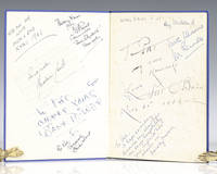
1939ref. 112422London: Macdonald and Co 1939. First edition of this overview of Hollywood. Quarto original cloth illustrated. Signed on the front pastedown and endpapers by Walt Disney and 13 other Hollywood actors and actresses including Chico Marx "To Pat Sincerely Chico Marx"; Pat O'Brien; "To Pat my own namesake Love Pat O'Brien Nov 21 1947; Deborah Kerr "I see a dark Stranger" on page 76 "with best wishes Deborah Kerr"; Merle Oberon "To Pat all the best Merle Oberon"; Joe E. Brown "To Pat Joe Brown." Brown was one of the most popular American comedians in the 1930s and 1940s with films like A Midsummer Night's Dream Earthworm Tractors Alibi Ike and Some Like It Hot. Jack Train "Best wishes Pat Jack Train Don’t' mind if I do"; Ray Milland "Merry Xmas Pat Ray Milland." Milland is best remembered for his Academy Award-winning portrayal of an alcoholic writer in The Lost Weekend leading man opposite John Wayne's corrupt character in Reap the Wild Wind 1942 the murder-plotting husband in Alfred Hitchcock's Dial M for Murder 1954 and Oliver Barrett III in Love Story. Two of the signatures are pasted onto the end papers while the rest are signed directly onto the end papers with one on page 76. Near fine in a very good dust jacket. An exceptional collection of signatures in this film review book. Macdonald and Co hardcover
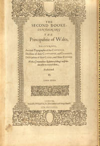
1611ref. 007684London: John Sudburie and George Humble 1611. Hardcover. Very Good. Elephant Folio - over 15 - 23" tall. SPEED John. Speed's Principality of Wales with Fourteen Double Page Maps In modern full black morocco by Bayntun decorative edge tooling. Spine raised bands gilt tooling & titles. Internally 1 ff Royal Stemme & verso County names 1 ff title page verso Royal Arms 99-124 pp 14 maps all double page maps dated 1610 but no date to tp some old professional gutter repairs new endpapers. Signatures: Z3 1 Bb1 Cc1-Cc2 Bb2 Dd1 Ee1-Ee2 Ff1 Ff1 Gg1-Gg2 Ff2 Hh1 Ii1. The pagination is complicated with double page illustrations maps printed on the verso and recto of numbered pages. 439279 mm. Chubb p29/30. John Sudburie and George Humble hardcover
1611ref. 031042Popes-head alley at y signe of y White Horse: Imprinted by William Hall and John Beale. Sold by John Sudbury and Georg Humble. 1611 A good copy of the extremely rare 1st edition of Speed's comprehensive work. In full leather binding which has been rebacked retaining the original boards which have blind tooled decoration and replacing the spine which has raised bands and gilt title label. This work continued Speed's 'Theatre of Great Britaine' - and the page numbering is continuous with it - the text starting at p155 and finishing at p 894 although the book is complete on its own. With engraved decorative title page; 4 page preface and text completing at p 894; Summary conclusion of the whole - 4 pp; The Second Index - 46 pp; and a one page 'Faults etc Sped'. The work has numerous engravings of coins seals and coats of arms; and is embellished throughout with decorative head and tailpieces and decorated initial capitals. The binding has been expertly repaired with some building up to one of the corners which had been lost. With new endpapers. The title page has been relaid on tissue. There is light nibbling to page edges up to the end of the preface but overall the paper is extremely thick and well-preserved. There is loss to the Faults page bottom corner and p 755 has a corner missing without loss of text. The pages vary from being completely clean to having spotting to having browning. There are occasional water stains to page margins - most usually the bottom margin - occasionally with a pinkish tinge at the page edge. A few pages have small repaired tears without loss. Imprinted by William Hall and John Beale. Sold by John Sudbury and Georg Humble. hardcover
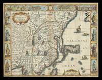
1626ref. 21928London: Are to be sold in pops-head Alley by G. Humble 1626 but 1627-1632. 405 by 515mm. 16 by 20.25 inches. Speed's map of China Double-page engraved map with hand-colour. A map of China also encompassing Korea and some of the islands of Japan from the first atlas compiled and published by an Englishman Speed's 'Prospect'. Along the top of the map is a decorative border with bird's-eye views of the islands of Macao after de Bry and Quinzay modern-day Hangzhou as well as dubiously accurate vignettes showing 'ye Manner of their Travelling by land' and 'the Manner of their Execution'. Along the sides of the map are depicted figures including one of the earliest European depictions of a Japanese soldier. Korea is shown as a long island and Japan is drawn after Ortelius and Teixeira. The Great Wall of China "built by ye King of China against ye breaking in of ye Tartars" separates China from the 'Desert Lop' which divides it from Russia. Here small diabolical figures are illustrated accompanied by the warning that "men are thought to be seduced by wonderfull illusions and divilish spitting". Accompanying text in English 'The Description of the Kingdome of China' is printed on the reverse. John Speed 1552-1629 was the outstanding cartographer of his age. By trade a merchant tailor but by proclivity a historian it was the patronage of Sir Fulke Greville poet and statesman that allowed him to pursue this interest in earnest. His 'Theatre of Great Britain' first published in 1611 or 1612 was the first large-scale printed atlas of the British Isles. The 'Prospect of the Most Famous Parts of the World' from which the present work is drawn appeared in 1627 bound with the 'Theatre' and is the first world atlas compiled by an Englishman to be published in England. Engraved in Amsterdam many of the maps are anglicized versions of works by Dutch makers in distinctive carte-à-figure style featuring borders with figures in local costume and city views. Chubb XXV; Shirley Atlases T.SPE-2a. Are to be sold in pops-head Alley by G. Humble,
1614ref. 655K5London: William Hall and John Beale 1614. Leather. Very Good. 16.5" by 11". Christoph Schweitzer. A very scarce edition of this highly historically significant work of British history written by an extremely influential historian and cartographer and offering a thorough exegesis of early British history from Julius Caesar to King James. A reissue of the 1611 first edition with imprint date altered as called for. ESTC Citation No. S122020. Folio. The work is very scarce with the 1614 reissue being a particularly scarce edition. Collated lacking errata leaf to the rear of the work and front and rear blank. Leaf 802 is misnumbered as leaf 801 as called for. Pagination is continuous from 'The Theatre of The Empire of Great Britaine' but the work is considered complete as a single volume. Contains the exceptionally scarce three leaves between pi 1 and Mm2 containing the author's preface. This is not present in the ESTC copy. Engraved title page has been trimmed and mounted with slight loss to fore edge. With an engraved title page and vignette engravings throughout by Christoph Schweitzer. John Speed is renowned for his work as both a leading English cartographer and historian and is considered one of the best known English mapmakers of the early modern period. Following encouragement from English antiquarian and historian William Camden Speed began this work published first in 1611 as the 'Historie of Great Britaine'. Many of the historical sources utilised for the work remain unknown although they do include the work of cartographers Christopher Saxton and John Norden. The work is considered a continuation of The Theatre of the Empire of Great Britaine first published between 1611 and 1612 within which is contained the first set of individual county maps of England and Wales. Speed himself considered his History of Great Britaine his major work the majority of which was funded by Sir Fulke Grevillean the Elizabethan poet dramatist and statesman. The work offers a highly detailed summary of Early English history and whilst the work has been criticised for a number of inaccuracies the subsequent frequent citations of the work in later historical pieces reflect its historical significance. Among others the work offers detailed information regarding the early successors and founders of English institutions including The Saxons Henry VIII and Edward IV. Written by one of the most influential historians and cartographers of the early modern period this extremely scarce 1614 edition of The History of Great Britaine is a sought after piece of significant historical and literary non fiction. Rebacked with the original contemporary calf boards preserved. Externally very smart with professional repair to the extremities. Slight rubbing and marking to the boards. Hinges slightly strained but firm. Evidence of bookplate removal to rear pastedown. Internally firmly bound. Engraved title page has been trimmed and mounted with slight loss to fore edge. Lacking front and rear blank and errata leaf to the rear of the work. The occasional light tidemark to the extremity of the occasional leaf. Handling marks and the occasional spot. The occasional contemporary ink annotations heavier to the final leaf. The occasional closed tear. Professional repair to leaf 5A2. Very Good William Hall and John Beale hardcover
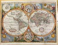
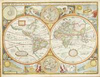
1659ref. M9858London 1659. Very Good backed on acid free tissue paper for long term preservation. Notes: Scarce third state of Robert Walton's decorative map of the World based upon the earlier edition of John Speed's World map. Double hemisphere map of the World with portraits of the four great explorers of the era Sir Francis Drake Thomas Candish Oliver Van Noort and Ferdinand Magellan. California is depicted as an Island with an unusual Northwest Coast of America. The map is surrounded by smaller celestial hemispheres and the four elements with notes on the South Pole & Straits of Magellan. Walton's map is rarer than John Speed's map and is of equal artistic and cartographic importance. Size : 398x530 mm 15.67x20.87 Inches Coloring: Hand Colored Reference: Shirley #397. Category: Maps World; unknown
1676ref. 9394London 1676. No Binding. Near Fine. 14 3/4 x 19 ¼ inches. Fine hand color; wear to bottom of centerfold else fine condition. A very attractive near-mint example. Speed's handsomely engraved work is one of the earliest English maps of the area and one of the first to demarcate the borders of colonial Virginia and Maryland. Just three years before the publication of Speed's map Augustine Herrman had conducted the first thorough surveys of Maryland at the behest of Lord Baltimore. Speed's was one of the first maps to adopt this groundbreaking cartography. However in general outline Speed still followed the prototype of Captain John Smith who conducted the first European survey of Chesapeake Bay. Speed's map "is the last major derivative of the Smith map and it is unique as an example of the transition from one basic prototype map to another. The delineation of the land area follows Smith while the toponymic prototype was the Herrman map of 1673." Verner in Tooley Mapping of America p.170 A particularly important feature derived from Herrman by Speed is the boundary line indicated by a double row of trees between Virginia and Maryland on the Eastern Shore. English text on the verso contains extensive descriptions of Virginia and Maryland. unknown
1676ref. 9394London 1676. No Binding. Near Fine. 14 3/4 x 19 ¼ inches. Fine hand color; wear to bottom of centerfold else fine condition. A very attractive near-mint example. Speed's handsomely engraved work is one of the earliest English maps of the area and one of the first to demarcate the borders of colonial Virginia and Maryland. Just three years before the publication of Speed's map Augustine Herrman had conducted the first thorough surveys of Maryland at the behest of Lord Baltimore. Speed's was one of the first maps to adopt this groundbreaking cartography. However in general outline Speed still followed the prototype of Captain John Smith who conducted the first European survey of Chesapeake Bay. Speed's map "is the last major derivative of the Smith map and it is unique as an example of the transition from one basic prototype map to another. The delineation of the land area follows Smith while the toponymic prototype was the Herrman map of 1673." Verner in Tooley Mapping of America p.170 A particularly important feature derived from Herrman by Speed is the boundary line indicated by a double row of trees between Virginia and Maryland on the Eastern Shore. English text on the verso contains extensive descriptions of Virginia and Maryland. unknown books
ref. 5309London: Sold by Tho:Bassett in Fleetstreet and Richard Chiswell in St. Pauls Church Yard. 1627-76. No binding. Very Good. 420 x 560 mm. in full recent wash colour in excellent condition with good margins all round. A very attractive example from the most prestigious English world atlas of the seventeenth century by John Speed 1552-1629. This is Speed's classic representation of the world surrounded by allegorical border depiction's of the four elements. The alignments of the 'Heavens and Elements' 'Figure of the Spheare' and illustrations of a solar and lunar eclipse appear in the four corners. Two attractive hemispheres of the heavens are in the centre and the whole is finished off with roundel portraits of the first four circumnavigators. Speed is the most famous of all the English map-makers. His two most celebrated publications are 'The Theatre of the Empire of Great Britain' covering the British Isles first published in 161112 and the 'Prospect of the Most Famous Parts of the World' first published in 1627. Speed was a tailor by profession with a great interest in history and maps. He wanted to produce an English atlas of the same high standards and quality as those published on the continent. The 'Prospect of the Most Famous Parts of the World' was published in 1627 two years before the death of Speed. Ownership of the atlas passed through various hands until sometime after 1668 when Roger Rea sold the rights to Thomas Bassett and Richard Chiswell. Bassett was a specialist in legal books and Chiswell was the publisher for the Royal Society. The final 1676 edition of the 'Prospect' includes eight further maps on seven sheets appearing for the first and only time. Phillips 1909- 488; Shirley 1984 317; Shirley 2004 T.Spe 1j; Skelton 1970 92; Wing 1945-51 S4886. Sold by Tho:Bassett in Fleetstreet and Richard Chiswell in St. Pauls Church Yard. 1627-[76] unknown
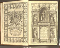
1676ref. 008029London: at the George in Fleet-street and at the Rose and Crown in St.Paul's Church-yard: Thomas Bassett & Richard Chiswell 1676. Hardcover. Very Good. Elephant Folio - over 15 - 23" tall. SPEED John. Regarded as a landmark in the history of British topography In 18 century sheep gilt edge tooling tips repaired. Re-spined to style raised bands decorative gilt tooling contemporary gilt/calf title label. Internally engraved armorial frontispiece and additional decorative title letterpress general title printed in red & black part titles to books two three and four printed in black Wales Scotland and Ireland and letterpress title to 'Prospect' also printed in black preliminary text leaves including dedication present 'A New and Accurat Map of the World.' erroneously bound in after the contents page of 'The Theatre' ninety-six complete uncoloured engraved maps 68 in the Theatre and 28 in the Prospect 16 2 126 5-6 5-8 Civil wars 10 leaves of roads 1 Scotland tp 1 129-146 pp. Prospect f the World 1676 2 3-56 pp 11 index several maps trimmed with slight loss to the strap-work margin very occasional marginal closed tears and staining lacking the maps of Berkshire Derbyshire and Shropshire but replaced with examples from the first edition of 1611 map of Derbyshire stained and toned Spain torn with loss to the upper left right corner tip Denmark torn with small area of loss to the right hand margin each map with descriptive text to the verso index bound at rear additional armorial frontispiece and decorative title trimmed to neat line and attached to recto and verso of blank leaf and additional title page both loosely inserted 18th-century bookplate of James Norman and old auction catalogue entry to the front paste down front free endpaper with ink stamp of I. Pickersgill ink name to tp Cha Hillear. 415274 mm.ESTC R13825 . Wing S4886. Chubb XXVII. John Speed's 'Theatre' is regarded as a landmark in the history of British topography. It was the first English attempt to produce a grand scale atlas including the first maps of the provinces of Ireland. The 'Theatre' evolved into a world atlas with the addition of the 'Prospect' in 1627. The 1676 edition of the Prospect includes seven new maps which were not present in the 1627 edition: Virginia and Maryland New England Carolina Jamaica and Barbados East India Russia and Canaan. Signatures: 9 B2-D2 E A F-R H1 T V-2O S1 Q2-3U -3 10 3X-3Z1 4A-4E. Prospect 1 B-2e 4f-4h2 with all maps printed on the inner forme of the register and text printed on the outer forme. Thomas Bassett & Richard Chiswell hardcover
ref. 10728London: Printed & Sold by Henry Overton at ye white Horse without Newgate. 1743. No binding. Very Good. ONE OF THE RAREST EDITIONS OF SPEED. Folio 435 x 290 mm. contemporary quarter calf marbled paper boards spine with raised bands black calf gilt title label affixed light wear. With engraved title page dated 1743 'A Sett of the Counties of England and Wales' with contemporary manuscript notations and 58 double-page engraved maps all in fine early outline colour front free endpaper with light water stain wormtrack though lower corner of first few leaves mostly in the margin Lincoln with wax mark Northumberland with old repaired tear final map with wrinkle to right side otherwise in good condition. A very fresh example of one of the rarest editions of John Speed's folio atlas. Hodson recorded only two complete examples I have now identified seven. Following Henry Overton's acquisition of the Speed plates from Christopher Browne in 1713 the printed maps had only been available in loose form. Clients did request them to be bound as atlases and a few survive. But until 1743 there was no intention on Overton's behalf to publish an atlas. Neither of the two adverts located refer to the maps being available in this manner. In February 1743 the papers of the day carried an advertisement stating 'Lately Re-Printed Speed's Sett of the Counties of England and Wales . each printed on a Sheet of Royal Paper neatly colour'd and bound in Marble Paper with red Leather Backs and Corners. Price 18s. Sold either in Setts or single Maps by Henry Overton .' These were available either 'Coloured or Plain' according to the index in the atlas. The reason for its issue is unclear. Following the earliest known issue of the maps whilst in Overton's possession two further distinct periods of issue can be defined before this atlas edition. Following the Jacobite rising in 1715 five of the northern county maps were revised to include Henry Overton's imprint those of Cumberland Durham Lancashire Northumberland and Westmoreland. They all included roads and in the case of Northumberland this can be sourced to the John Warburton map of the county published in August 1716. Of this Speed—Overton II as it is called there are two known examples. During this period the plates became very worn and Overton had many of them retouched. There are two known examples falling into this classification of which only one survives. For this final issue in atlas form many of the old dates on the plates were removed crudely. Also for a reason unknown the date 1738 was added to that of Huntington. This Speed — Overton IV as it is classified contained the same engraved title page by Robert White 1646-1703 with the addition of 'by John Speed. Reprinted Anno 1743.' The typographic index is entirely re-set with the title 'A Sett of the Counties of England and Wales with their Ilands containing Fifty Eight MAPS; each on a Sheet of Royal Paper. By JOHN SPEED. Reprinted in the YEAR 1743. With ADDITIONS.' There follows a list of the 58 maps after which is an advert stating 'Sold either in Compleat Setts Bound or Single either Coloured or Plain … Neatly Bound in Marble Paper with Leather Back and Corners Coloured Price 1l. 4s.' Overton's two sheet atlas of the world is also noted. Known complete examples: Burden collection Cambridge University Library Atlas 3.74.3 Phillips auction 30 April 1987 lot 477 to Burgess Bonham's London 27 March 2007 lot 469 with other maps Bonham's London 11 November 2015 lot 146 with 6 additional maps Sizergh Castle Cumbria National Trust This example The Speed — Overton atlas or collection of maps was still available for sale on 7 October 1745 during the Jacobite rising when an advert was placed in the 'General Advertiser'. The atlas no doubt continued to be available until his death in 1751 and was probably still available at the hands of his successor his son also Henry Overton. Although Henry the Younger remained in business until at least 1763 i Printed & Sold by Henry Overton at ye white Horse without Newgate. 1743 unknown