1,011 results
2007ref. 22209Sony, 2007. EUPH075CD 2 CDs CD
1957Very nice typewriting instruction book. Full blue cloth boards. 8 1/8"w x 11 "h. 172 pages. Book is made to stand up by itself so you can look at it while typing. Previous student's name inside.
ref. Bloomsbury-9781586832322Linworth. Paperback. New. 104 pages Linworth paperback
2008ref. DADAX1586832328Bloomsbury Academic 2008-02-15. Illustrated. paperback. New. 8.50x0.21x11.00. Buy with confidence. Excellent Customer Service & Return policy. Bloomsbury Academic paperback
1970ref. 1206673PN. New. 1970. Reprint Edition. Soft Cover. Date is copyright date; this is a later reprint edition . PN paperback
1760ref. e8831London: W. Owen at Homer's Head Temple-Bar. G : in Good condition. Boards scuffed with edge wear. Spine cracked with wear at base. Text block firm. 1760. Fourth Edition Revised and Corrected. Quarter leather marbled board cover. 180mm x 100mm 7" x 4". xii vi 328pp 118pp. Two engraved plates. ' To which is added a translation of Dr. Speed's commentary on sea water. As also an account of the nature properties and uses of all the remarkable mineral waters in Great Britain.' Bound with an extract pages 165-283 from Francis Fuller ' Medicina Gymnastica: or A treatise concerning the power of exercise with respect to the animal oeconomy and the great necessity of it in the cure of several distempers'. . W. Owen, at Homer's Head, Temple-Bar hardcover
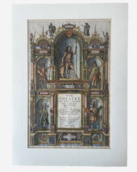
1627ref. 003914George Humble. SPEED John. A hand coloured title page from 'The Theatre of the Empire of Great Britaine'. London: George Humble 1627. Hand-coloured engraved allegorical title page from Speed's celebrated atlas of Great Britain. Image size approximately 390 x 250 mm. Mounted for display. Overall an excellent near fine example mounted verso with archival tape. This title page is from the 1627 edition on laid paper with attractive early hand-colouring depicting allegorical and historical figures representing the successive peoples of Britain including the Britons Romans Saxons Danes and Normans surrounding the architectural title framework. Imprint at foot: "Are to be sold by George Humble at the White Horse in Popes-head Alley." The engraved title page formed part of John Speed's monumental The Theatre of the Empire of Great Britaine first issued in 1611 and regarded as the first major atlas of the British Isles produced by an English cartographer. . Very Good. Soft cover. 1st Edition. 1st Printing. 1627. George Humble paperback
2026ref. LRB537161Paris: Editions Recreasoft 2026 Language: English. Approximately 580 pages. English : Print-on-demand reprint. Original edition : 1883. This modern reproduction of A history of Southampton; partly from the MS. of Dr. Speed in the Southampton Archives by Davies J. Silvester; Speed John 1703-1781 makes an old or rare text available for consultation bibliographic research and specialized collections. Book images are non-contractual. Editions Recreasoft. Softcover. New. Editions Recreasoft paperback
1841ref. 56464Baltimore: Sherwood & Co 1841. First edition 8vo pamphlet 2 12 2; later paper wrappers; lightly foxed and folded very good. A pro-slavery tract arguing that slavery "is one of the primitive domestic relations ordained and established by the Creator. as one of the best means of promoting the happiness of the human family." Sabin 80086. Afro-Americana 9365 both incorrectly attributing the work to J. J. Sheed. See Sabin 89236 for correction. Sherwood & Co unknown
1841ref. 56464Baltimore: Sherwood & Co 1841. First edition 8vo pamphlet 2 12 2; later paper wrappers; lightly foxed and folded very good. A pro-slavery tract arguing that slavery "is one of the primitive domestic relations ordained and established by the Creator. as one of the best means of promoting the happiness of the human family." Sabin 80086. Afro-Americana 9365 both incorrectly attributing the work to J. J. Sheed. See Sabin 89236 for correction. Sherwood & Co unknown books
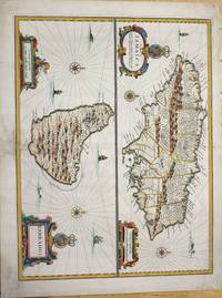
1676ref. M7404London c.1676. Very good the lower part of the central fold reinforced and backed with acid free tissue paper for long term preservation. Notes: From Speed's A Prospect of the Most Famous Parts of the World. Size : 389x510 mm 15.31x20.08 Inches Coloring: Hand Colored Reference: Kapp: Printed Maps Of Jamaica 22 Campbell: Printed Maps Of Barbados MCS 21 no.5 pl. III Category: Maps West Indies Other Islands; unknown
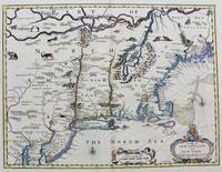
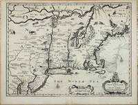
1676ref. M8290London. : Tho: Basset; Richard Chiswell c. 1676. Very Good. Notes: A significant map of the British colonies in North America covering the east coast from Maryland and New Jersey northward through New York and New England to the French possessions in Canada. It depicts the territories acquired by the British with the capture of New Amsterdam in 1664 which changed European influence in the colonies from the Dutch to the English. It is the first appearance of name Boston and the first map to use the term New York for both Manhattan and the colony. It is also one of the first maps to show New Jersey. The map is decorated with various animals in the interior of the map two compass roses two cartouches and a coat of arms. With English text on verso that provides interesting information on the colonies. Size : 381x497 mm 15.00x19.55 Inches Coloring: Hand Colored Category: Maps United States East; Tho: Basset; Richard Chiswell unknown
ref. 10914London: Sold by Tho:Bassett in Fleetstreet and Richard Chiswell in St. Pauls Church Yard. 1676. No binding. Very Good. 380 x 505 mm. in good condition. This fine map of New England was published at a important period of its history. It is from the most prestigious English world atlas of the seventeenth century by John Speed 1552-1629. Speed is the most famous of all the English map-makers. His two most celebrated publications are 'The Theatre of the Empire of Great Britain' covering the British Isles first published in 161112 and the 'Prospect of the Most Famous Parts of the World' first published in 1627. Speed was a tailor by profession with a great interest in history and maps. He wanted to produce an English atlas of the same high standards and quality as those published on the continent. The 'Prospect of the Most Famous Parts of the World' was published in 1627 two years before the death of Speed. Ownership of the atlas passed through various hands until sometime after 1668 when Roger Rea sold the rights to Thomas Bassett and Richard Chiswell. Bassett was a specialist in legal books and Chiswell was the publisher for the Royal Society. The final 1676 edition of the 'Prospect' includes eight further maps on seven sheets appearing for the first and only time four of these are of the 'Kings dominions abroad' the American colonies: New England Virginia and Maryland Carolina Jamaica and Barbados. The cartography of New England is drawn from the Joannes Janssonius 'BELGII NOVI .' 1651. In this example though the cartographer eliminates the south-westerly regions of the map as the intention was to provide a more detailed map of the Virginia and Maryland area. In fact it is most closely derived from the Nicolaas Jansz. Visscher version published c.1651. 'This is particularly noticeable when studying the decorative fauna depicted and the additional placenames that Visscher introduced such as Zuyder Zee south of Cape Cod here translated to South Sea. The only major cartographic alteration is the narrowing of the Delaware peninsula utilising the Augustine Herrman map 167374. Most of the differences reflect the anglicising of the map; one of the more notable additions is Boston. This is one of the first maps to depict the English pre-eminence in the region. The text on the reverse of the map describes the region although examples are known without it.' Burden. Burden 2007 455; McCorkle 2001 676.6; Phillips 'Atlases' 488; Shirley 2004 T.Spe 1j; Skelton 1970 92; Stokes 1915-28 I p. 148 & II p. 96 n.36. Sold by Tho:Bassett in Fleetstreet and Richard Chiswell in St. Pauls Church Yard. 1676 unknown
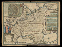
1676ref. 21930London: Sold by Tho: Basset in Fleet Street and Richard Chiswell in St. Pauls Church yard 1676. 405 by 515mm. 16 by 20.25 inches. Speed's map of Russia Double-page engraved map with hand-colour. A map of Russia one of the nine new maps added to the 1676 edition of Speed's 'Prospect' the first atlas compiled and published by an Englishman. Unusually this map is not in the carte-à-figure style that characterizes the 'Prospect'. Instead set in the top left-hand corner of the map is a detailed plan of Moscow with points of particular interest such as 'The Emperours Palace' and 'The Horse market' labelled. On the right-hand side is an elaborate cartouche containing views including 'Archangel' Arkhangelsk and 'A Hott House'. Accompanying text in English 'The Description of Russia' is printed on the reverse. John Speed 1552-1629 was the outstanding cartographer of his age. By trade a merchant tailor but by proclivity a historian it was the patronage of Sir Fulke Greville poet and statesman that allowed him to pursue this interest in earnest. His 'Theatre of Great Britain' first published in 1611 or 1612 was the first large-scale printed atlas of the British Isles. The 'Prospect of the Most Famous Parts of the World' from which the present work is drawn appeared in 1627 bound with the 'Theatre' and is the first world atlas compiled by an Englishman to be published in England. Engraved in Amsterdam many of the maps are anglicized versions of works by Dutch makers in distinctive carte-à-figure style featuring borders with figures in local costume and city views. This map is from the 1676 edition of the 'Prospect' published by Thomas Bassett and Richard Chiswell. While not as rare as the earlier publications this edition is perhaps the most important given that it is the first to include the nine new maps: among them Virginia and Maryland Barbados and the present example Russia. It is also the last time that the 'Prospect' was printed as an atlas. Shirley Atlases T.SPE-2f. Sold by Tho: Basset in Fleet Street and Richard Chiswell in St. Pauls Church yard,
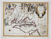
1676ref. 9394London 1676. No Binding. Near Fine. 14 3/4 x 19 ¼ inches. Fine hand color; wear to bottom of centerfold else fine condition. A very attractive near-mint example. Speed's handsomely engraved work is one of the earliest English maps of the area and one of the first to demarcate the borders of colonial Virginia and Maryland. Just three years before the publication of Speed's map Augustine Herrman had conducted the first thorough surveys of Maryland at the behest of Lord Baltimore. Speed's was one of the first maps to adopt this groundbreaking cartography. However in general outline Speed still followed the prototype of Captain John Smith who conducted the first European survey of Chesapeake Bay. Speed's map "is the last major derivative of the Smith map and it is unique as an example of the transition from one basic prototype map to another. The delineation of the land area follows Smith while the toponymic prototype was the Herrman map of 1673." Verner in Tooley Mapping of America p.170 A particularly important feature derived from Herrman by Speed is the boundary line indicated by a double row of trees between Virginia and Maryland on the Eastern Shore. English text on the verso contains extensive descriptions of Virginia and Maryland. unknown
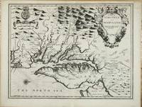
ref. 10915London: Sold by Tho:Bassett in Fleetstreet and Richard Chiswell in St. Pauls Church Yard. 1676. No binding. Good. 380 x 500 mm. with a small upper right corner margin repair otherwise in good condition. One of the maps 'relating to North America introduced into the 1676 edition of John Speed's 'Theatre of the Empire of Great Britaine' is this one of Virginia and Maryland. Augustine Herrman's landmark map of the region had been published three years earlier and bore a royal Privilege. However that did not protect its superior cartography from being poached. Here the mapmaker is more circumspect following John Smith's general outline from 1612. He draws upon the Herrman mainly for toponomy. As such it is the first printed map to utilise its improved geography although the Robert Morden and William Berry 'Map of New England .' was advertised just four days later. We should also bear in mind the possibility of Speed's 'Epitome' being issued earlier still. As such it is particularly important in representing the transition between two fundamental maps of the region. Other areas where the Herrman was used is in the depiction of the Delaware Bay and River which was omitted altogether from the Smith map and an improved delineation of the north-eastern shore of Chesapeake Bay. An independent source for the Atlantic coast of the peninsula is used. The June 1668 border settlement between Maryland and Virginia on the eastern shore is shown with the Herrman-like usage of a double line of trees. One item that did not appear on either of the progenitor maps is a brief inclusion of northern Carolina. The text on the reverse of the map is a condensed version of that found in John Ogilby's America 1671' Burden. John Speed 1552-1629 is the most famous of all the English map-makers. His two most celebrated publications are 'The Theatre of the Empire of Great Britain' covering the British Isles first published in 161112 and the 'Prospect of the Most Famous Parts of the World' first published in 1627. Speed was a tailor by profession with a great interest in history and maps. He wanted to produce an English atlas of the same high standards and quality as those published on the continent. The 'Prospect of the Most Famous Parts of the World' was published in 1627 two years before the death of Speed. Ownership of the atlas passed through various hands until sometime after 1668 when Roger Rea sold the rights to Thomas Bassett and Richard Chiswell. Bassett was a specialist in legal books and Chiswell was the publisher for the Royal Society. The final 1676 edition of the 'Prospect' includes eight further maps on seven sheets appearing for the first and only time. Baer 1949 no. 86; Burden 1996 no. 164; Morison Papenfuse Bramucci & Janson-La Palme 1983 pp. 17-19; Papenfuse & Coale 1982 pp. 16-18; Phillips 'Atlases' 488; Shirley 2004 T.Spe 1j; Skelton 1970 92; Verner 1968 pp. 170. Sold by Tho:Bassett in Fleetstreet and Richard Chiswell in St. Pauls Church Yard. 1676 unknown
1676ref. 9394London 1676. No Binding. Near Fine. 14 3/4 x 19 ¼ inches. Fine hand color; wear to bottom of centerfold else fine condition. A very attractive near-mint example. Speed's handsomely engraved work is one of the earliest English maps of the area and one of the first to demarcate the borders of colonial Virginia and Maryland. Just three years before the publication of Speed's map Augustine Herrman had conducted the first thorough surveys of Maryland at the behest of Lord Baltimore. Speed's was one of the first maps to adopt this groundbreaking cartography. However in general outline Speed still followed the prototype of Captain John Smith who conducted the first European survey of Chesapeake Bay. Speed's map "is the last major derivative of the Smith map and it is unique as an example of the transition from one basic prototype map to another. The delineation of the land area follows Smith while the toponymic prototype was the Herrman map of 1673." Verner in Tooley Mapping of America p.170 A particularly important feature derived from Herrman by Speed is the boundary line indicated by a double row of trees between Virginia and Maryland on the Eastern Shore. English text on the verso contains extensive descriptions of Virginia and Maryland. unknown books
ref. 23403mounted to an album leaf 4 1/2 x 3 7/8 inches overall. unknown
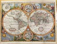
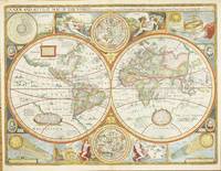
1659ref. M9858London 1659. Very Good backed on acid free tissue paper for long term preservation. Notes: Scarce third state of Robert Walton's decorative map of the World based upon the earlier edition of John Speed's World map. Double hemisphere map of the World with portraits of the four great explorers of the era Sir Francis Drake Thomas Candish Oliver Van Noort and Ferdinand Magellan. California is depicted as an Island with an unusual Northwest Coast of America. The map is surrounded by smaller celestial hemispheres and the four elements with notes on the South Pole & Straits of Magellan. Walton's map is rarer than John Speed's map and is of equal artistic and cartographic importance. Size : 398x530 mm 15.67x20.87 Inches Coloring: Hand Colored Reference: Shirley #397. Category: Maps World; unknown
ref. 5309London: Sold by Tho:Bassett in Fleetstreet and Richard Chiswell in St. Pauls Church Yard. 1627-76. No binding. Very Good. 420 x 560 mm. in full recent wash colour in excellent condition with good margins all round. A very attractive example from the most prestigious English world atlas of the seventeenth century by John Speed 1552-1629. This is Speed's classic representation of the world surrounded by allegorical border depiction's of the four elements. The alignments of the 'Heavens and Elements' 'Figure of the Spheare' and illustrations of a solar and lunar eclipse appear in the four corners. Two attractive hemispheres of the heavens are in the centre and the whole is finished off with roundel portraits of the first four circumnavigators. Speed is the most famous of all the English map-makers. His two most celebrated publications are 'The Theatre of the Empire of Great Britain' covering the British Isles first published in 161112 and the 'Prospect of the Most Famous Parts of the World' first published in 1627. Speed was a tailor by profession with a great interest in history and maps. He wanted to produce an English atlas of the same high standards and quality as those published on the continent. The 'Prospect of the Most Famous Parts of the World' was published in 1627 two years before the death of Speed. Ownership of the atlas passed through various hands until sometime after 1668 when Roger Rea sold the rights to Thomas Bassett and Richard Chiswell. Bassett was a specialist in legal books and Chiswell was the publisher for the Royal Society. The final 1676 edition of the 'Prospect' includes eight further maps on seven sheets appearing for the first and only time. Phillips 1909- 488; Shirley 1984 317; Shirley 2004 T.Spe 1j; Skelton 1970 92; Wing 1945-51 S4886. Sold by Tho:Bassett in Fleetstreet and Richard Chiswell in St. Pauls Church Yard. 1627-[76] unknown
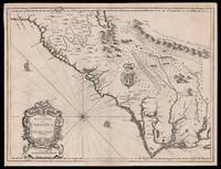
1676ref. 15098London: Thomas Bassett and Richard Chiswell 1676. 380 by 505mm. 15 by 20 inches. Sheet size 408 by 530mm 19 x 21 inches. Engraved map with text on verso. A fine and attractive map of the Carolina colony. Publishers Thomas Bassett and Richard Chiswell republished English cartographer John Speed's 1552-1629 popular 1611 atlas "The Theatre of the Empire of Great Britain" in 1676. As a supplement they included new section "A Prospect of the most Famous parts of the World" which contained maps engraved by Francis Lamb of the English colonies of New England and New York Virginia and Maryland Carolina and Florida and Jamaica and Barbados. This map depicts the Carolina colony in 1676 drawing from the Lord Proprietor's Map by royal geographer John Ogilby and the explorations of John Lederer fl. 1670-1675. The map orients the West to the top and depicts the coastline from Cape Charles at the mouth of the Chesapeake Bay to the north and St Augustine Florida to the south. Looking inland the Appalachian Mountains marked as "Apalathean Mountains" cut across the top right section of the map. The present map features a cartouche where the Ogilby publication had an inset map of the Ashley and Cooper Rivers. This map is one of the first to name Charleston "Charles Town" on the banks of the Ashley River. The map correctly identifies the town on the south bank of the Ashley River whereas Speed's smaller format map of Carolina incorrectly places the town on the north banks of the river. King Charles II granted eight Lord Proprietors land in North America that extended between 31 and 36 degrees latitude later extended to 29 degrees. Lederer was a German explorer who travelled West from the East coast of Virginia in hopes of finding the Pacific and the "Sea of China" with its associated riches. He never did reach the Pacific - unsurprisingly - but his personal records of his travels influenced contemporary maps. His description of the "Arenosa Desert" reflects Lederer's memory of crossing the Carolina pine barrens in the blistering summer heat. The "Great Lake" is likely the Catawba flooded which he mistook as permanent. In total Lederer traipsed across Virginia and the Eastern coast three times making it as far as the Blue Ridge mountains. Lederer's discoveries are recorded in Sir William Talbot's translation of the explorer's account from Latin to English and published in London in 1672 as "The Discoveries of John Lederer in three several Marches from Virginia To the West of Carolina." On the verso the text describes Lederer's journeys and discoveries. Burden 457 Cumming 77 Thomas Bassett and Richard Chiswell, unknown
2025ref. __050002409XThames & Hudson 2025. Paperback. New. 2nd edition. 464 pages. 8.51x1.21x10.81 inches. Thames & Hudson paperback
ref. 050002409X-11-1W. W. Norton & Company Limited. Second. Very Good. It's a well-cared-for item that has seen limited use. The item may show minor signs of wear. All the text is legible with all pages included. It may have slight markings and/or highlighting. W. W. Norton & Company Limited unknown
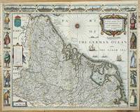
ref. 5319London: Sold by Tho:Bassett in Fleetstreet and Richard Chiswell in St. Pauls Church Yard. 1627-76. No binding. Good. 420 x 540 mm. with recent outline and full wash colour extended margins affecting the neatline in the two lower corners otherwise a good dark impression. A very attractive example from the most prestigious English world atlas of the seventeenth century by John Speed 1552-1629. Orientated with the north to the right this map features the Low Countries in the seventeenth century before they became present day Belgium and the Netherlands. The carte-a-figures bears various national dress flanking both sides and above are found eight views of towns including Amsterdam Antwerpen Ghendt Middelburg Groeningen Zutphen Utrecht and Atrecht. Speed is the most famous of all the English map-makers. His two most celebrated publications are 'The Theatre of the Empire of Great Britain' covering the British Isles first published in 161112 and the 'Prospect of the Most Famous Parts of the World' first published in 1627. Speed was a tailor by profession with a great interest in history and maps. He wanted to produce an English atlas of the same high standards and quality as those published on the continent. The 'Prospect of the Most Famous Parts of the World' was published in 1627 two years before the death of Speed. Ownership of the atlas passed through various hands until sometime after 1668 when Roger Rea sold the rights to Thomas Bassett and Richard Chiswell. Bassett was a specialist in legal books and Chiswell was the publisher for the Royal Society. The final 1676 edition of the 'Prospect' includes eight further maps on seven sheets appearing for the first and only time. Phillips 'Atlases' 488; Shirley BL T.Spe 1j; Skelton 92; Wing S4886. Sold by Tho:Bassett in Fleetstreet and Richard Chiswell in St. Pauls Church Yard. 1627-[76] unknown