John Speed; Robert WaltonBiblio.com
1,312 results
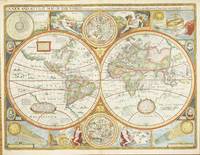
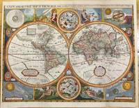
1659ref. M9858London 1659. Very Good backed on acid free tissue paper for long term preservation. Notes: Scarce third state of Robert Walton's decorative map of the World based upon the earlier edition of John Speed's World map. Double hemisphere map of the World with portraits of the four great explorers of the era Sir Francis Drake Thomas Candish Oliver Van Noort and Ferdinand Magellan. California is depicted as an Island with an unusual Northwest Coast of America. The map is surrounded by smaller celestial hemispheres and the four elements with notes on the South Pole & Straits of Magellan. Walton's map is rarer than John Speed's map and is of equal artistic and cartographic importance. Size : 398x530 mm 15.67x20.87 Inches Coloring: Hand Colored Reference: Shirley #397. Category: Maps World; unknown
ref. 5309London: Sold by Tho:Bassett in Fleetstreet and Richard Chiswell in St. Pauls Church Yard. 1627-76. No binding. Very Good. 420 x 560 mm. in full recent wash colour in excellent condition with good margins all round. A very attractive example from the most prestigious English world atlas of the seventeenth century by John Speed 1552-1629. This is Speed's classic representation of the world surrounded by allegorical border depiction's of the four elements. The alignments of the 'Heavens and Elements' 'Figure of the Spheare' and illustrations of a solar and lunar eclipse appear in the four corners. Two attractive hemispheres of the heavens are in the centre and the whole is finished off with roundel portraits of the first four circumnavigators. Speed is the most famous of all the English map-makers. His two most celebrated publications are 'The Theatre of the Empire of Great Britain' covering the British Isles first published in 161112 and the 'Prospect of the Most Famous Parts of the World' first published in 1627. Speed was a tailor by profession with a great interest in history and maps. He wanted to produce an English atlas of the same high standards and quality as those published on the continent. The 'Prospect of the Most Famous Parts of the World' was published in 1627 two years before the death of Speed. Ownership of the atlas passed through various hands until sometime after 1668 when Roger Rea sold the rights to Thomas Bassett and Richard Chiswell. Bassett was a specialist in legal books and Chiswell was the publisher for the Royal Society. The final 1676 edition of the 'Prospect' includes eight further maps on seven sheets appearing for the first and only time. Phillips 1909- 488; Shirley 1984 317; Shirley 2004 T.Spe 1j; Skelton 1970 92; Wing 1945-51 S4886. Sold by Tho:Bassett in Fleetstreet and Richard Chiswell in St. Pauls Church Yard. 1627-[76] unknown
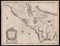
1676ref. 15098London: Thomas Bassett and Richard Chiswell 1676. 380 by 505mm. 15 by 20 inches. Sheet size 408 by 530mm 19 x 21 inches. Engraved map with text on verso. A fine and attractive map of the Carolina colony. Publishers Thomas Bassett and Richard Chiswell republished English cartographer John Speed's 1552-1629 popular 1611 atlas "The Theatre of the Empire of Great Britain" in 1676. As a supplement they included new section "A Prospect of the most Famous parts of the World" which contained maps engraved by Francis Lamb of the English colonies of New England and New York Virginia and Maryland Carolina and Florida and Jamaica and Barbados. This map depicts the Carolina colony in 1676 drawing from the Lord Proprietor's Map by royal geographer John Ogilby and the explorations of John Lederer fl. 1670-1675. The map orients the West to the top and depicts the coastline from Cape Charles at the mouth of the Chesapeake Bay to the north and St Augustine Florida to the south. Looking inland the Appalachian Mountains marked as "Apalathean Mountains" cut across the top right section of the map. The present map features a cartouche where the Ogilby publication had an inset map of the Ashley and Cooper Rivers. This map is one of the first to name Charleston "Charles Town" on the banks of the Ashley River. The map correctly identifies the town on the south bank of the Ashley River whereas Speed's smaller format map of Carolina incorrectly places the town on the north banks of the river. King Charles II granted eight Lord Proprietors land in North America that extended between 31 and 36 degrees latitude later extended to 29 degrees. Lederer was a German explorer who travelled West from the East coast of Virginia in hopes of finding the Pacific and the "Sea of China" with its associated riches. He never did reach the Pacific - unsurprisingly - but his personal records of his travels influenced contemporary maps. His description of the "Arenosa Desert" reflects Lederer's memory of crossing the Carolina pine barrens in the blistering summer heat. The "Great Lake" is likely the Catawba flooded which he mistook as permanent. In total Lederer traipsed across Virginia and the Eastern coast three times making it as far as the Blue Ridge mountains. Lederer's discoveries are recorded in Sir William Talbot's translation of the explorer's account from Latin to English and published in London in 1672 as "The Discoveries of John Lederer in three several Marches from Virginia To the West of Carolina." On the verso the text describes Lederer's journeys and discoveries. Burden 457 Cumming 77 Thomas Bassett and Richard Chiswell, unknown
2025ref. __050002409XThames & Hudson 2025. Paperback. New. 2nd edition. 464 pages. 8.51x1.21x10.81 inches. Thames & Hudson paperback
ref. 050002409X-11-1W. W. Norton & Company Limited. Second. Very Good. It's a well-cared-for item that has seen limited use. The item may show minor signs of wear. All the text is legible with all pages included. It may have slight markings and/or highlighting. W. W. Norton & Company Limited unknown
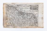
ref. 35946London: William Humble. 1646. 8.5 x 12.4 cm. Uncoloured. Miniature map of the Low Countries. Text on verso. Small section of lower margin neatly restored. Some light toning and show through text otherwise good. [London: William Humble. 1646] unknown
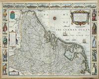
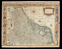
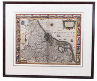
ref. 5319London: Sold by Tho:Bassett in Fleetstreet and Richard Chiswell in St. Pauls Church Yard. 1627-76. No binding. Good. 420 x 540 mm. with recent outline and full wash colour extended margins affecting the neatline in the two lower corners otherwise a good dark impression. A very attractive example from the most prestigious English world atlas of the seventeenth century by John Speed 1552-1629. Orientated with the north to the right this map features the Low Countries in the seventeenth century before they became present day Belgium and the Netherlands. The carte-a-figures bears various national dress flanking both sides and above are found eight views of towns including Amsterdam Antwerpen Ghendt Middelburg Groeningen Zutphen Utrecht and Atrecht. Speed is the most famous of all the English map-makers. His two most celebrated publications are 'The Theatre of the Empire of Great Britain' covering the British Isles first published in 161112 and the 'Prospect of the Most Famous Parts of the World' first published in 1627. Speed was a tailor by profession with a great interest in history and maps. He wanted to produce an English atlas of the same high standards and quality as those published on the continent. The 'Prospect of the Most Famous Parts of the World' was published in 1627 two years before the death of Speed. Ownership of the atlas passed through various hands until sometime after 1668 when Roger Rea sold the rights to Thomas Bassett and Richard Chiswell. Bassett was a specialist in legal books and Chiswell was the publisher for the Royal Society. The final 1676 edition of the 'Prospect' includes eight further maps on seven sheets appearing for the first and only time. Phillips 'Atlases' 488; Shirley BL T.Spe 1j; Skelton 92; Wing S4886. Sold by Tho:Bassett in Fleetstreet and Richard Chiswell in St. Pauls Church Yard. 1627-[76] unknown
1676ref. 21920London: Are to be sold by Thomas Bassett in Fleet Street and Richard Chiswell in St. Pauls Churchyard 1676. 420 by 540mm. 16.5 by 21.25 inches. Speed's map of 'Low Germanie' Double-page engraved map with hand-colour. A map of 'Low Germanie' the modern-day Netherlands from the 1676 edition of the first atlas compiled and published by an Englishman Speed's 'Prospect'. A decorative border along the top of the map depicts views of major cities among them Amsterdam and Utrecht. Along each side of the map are illustrated figures in regional costume. Accompanying text in English 'The Description of Belgia' is printed on the reverse. John Speed 1552-1629 was the outstanding cartographer of his age. By trade a merchant tailor but by proclivity a historian it was the patronage of Sir Fulke Greville poet and statesman that allowed him to pursue this interest in earnest. His 'Theatre of Great Britain' first published in 1611 or 1612 was the first large-scale printed atlas of the British Isles. The 'Prospect of the Most Famous Parts of the World' from which the present work is drawn appeared in 1627 bound with the 'Theatre' and is the first world atlas compiled by an Englishman to be published in England. Engraved in Amsterdam many of the maps are anglicized versions of works by Dutch makers in distinctive carte-à-figure style featuring borders with figures in local costume and city views. This map is from the 1676 edition of the 'Prospect' published by Thomas Bassett and Richard Chiswell. While not as rare as the earlier publications this edition is perhaps the most important given that it is the first to include the nine new maps: among them Virginia and Maryland Barbados and Russia. It is also the last time that the 'Prospect' was printed as an atlas. Shirley Atlases T.SPE-2f. Are to be sold by Thomas Bassett in Fleet Street and Richard Chiswell in St. Pauls Churchyard,
1626ref. ACH8NIO8K9DULondon: George Humble 1626. Framed. 41 x 53 cm. Engraved map with hand coloured borders probably by Pieter van den Keere 1571-after 1646. Incorporating a fine compass-rose with 32 rhumb lines and names of the wind-directions a coat of arms of France a title-cartouche a legend "A catalogue of the cities et ! villages in everie Province" and an indication of scale ca. 1:1.120.000. The map is topped by 8 hand coloured miniature profiles of major cities and bordered by hand coloured figures in local costume at the left 5 male figures and right 5 female figures. Very fine and attractive map in its first edition as published in John Speed's A Prospect of the most famous Parts of the World London 1627. The very successful map was republished in 1654 in two different states and 1674. Its decorative border incorporates profiles of Amsterdam Antwerp Ghent Middelburg Groningen Zutphen Utrecht and Atrecht and figures depicting "a Gentle woman" "a Brabanders wiffe!" "a Hollanders wiffe !" "a Fishers wiffe!" "a Contreywoman!" and their male counterparts.Slightly creased with restored tears along the head and foot of the central fold. Otherwise a very good copy.l Van der Heijden 88 first state of 4. George Humble, unknown
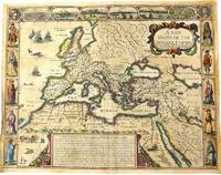
1676ref. M10992London 1676. Very Good. Notes: English text on verso. Map of the Roman Empire it is surrounded by views of the cities of Geneva Rome Jerusalem Venice and Constantinople and Alexandria and figures displaying the customary dress of Italians Egyptians Turks and Spaniards with their wives. John Speed 1552 –1629 was an English cartographer and historian. He is known as England's most famous Stuart period mapmaker. His maps of English counties are often found framed in homes throughout the United Kingdom. For a series of maps Speed partnered with Dutch engraver Jodocus Hondius. Size : 393x509 mm 15.47x20.04 Inches Coloring: Original Hand Coloring Category: Maps Europe Continent; Maps Asia Continent; unknown
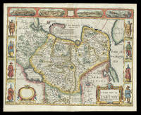
1676ref. 21929London: and are to be sold by Tho: Bassett in Fleet Street & Richard Chiswell in St. Pauls Churchyard 1676. 395 by 510mm. 15.5 by 20 inches. Speed's map of 'Tartary' Double-page engraved map with hand-colour. A map of Tartary encompassing parts of modern-day Siberia and Central Asia from the 1676 edition of the first atlas compiled and published by an Englishman Speed's 'Prospect'. The decorative border that runs along the top of the map depicts views of major cities as well as the house built on 'Nova Zemla' Novaya Zemlya by the explorer Willem Barentsz and his crew stranded there in 1596 here presented fending off a polar bear. Along each side are illustrated figures in regional costume. Accompanying text in English 'The Description of the Kingdom of Tartary' is printed on the reverse. John Speed 1552-1629 was the outstanding cartographer of his age. By trade a merchant tailor but by proclivity a historian it was the patronage of Sir Fulke Greville poet and statesman that allowed him to pursue this interest in earnest. His 'Theatre of Great Britain' first published in 1611 or 1612 was the first large-scale printed atlas of the British Isles. The 'Prospect of the Most Famous Parts of the World' from which the present work is drawn appeared in 1627 bound with the 'Theatre' and is the first world atlas compiled by an Englishman to be published in England. Engraved in Amsterdam many of the maps are anglicized versions of works by Dutch makers in distinctive carte-à-figure style featuring borders with figures in local costume and city views. This map is from the 1676 edition of the 'Prospect' published by Thomas Bassett and Richard Chiswell. While not as rare as the earlier publications this edition is perhaps the most important given that it is the first to include the nine new maps: among them Virginia and Maryland Barbados and Russia. It is also the last time that the 'Prospect' was printed as an atlas. Shirley Atlases T.SPE-2f. and are to be sold by Tho: Bassett in Fleet Street & Richard Chiswell in St. Pauls Churchyard,
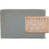
1668ref. 21680London: Printed for Roger Rea 1668. Third edition. This was first published in 1631. Maps removed they were printed with the text. lacking A2 &7 B5 C2 &8 D5 E2 &8 F5 G2 &7 H5 I2 &8 K4 L1 & 6 M3 &7 and N4 &8. 1 vols. Oblong 24mo 6 1/2 x 4 inches. Later green wrappers some browning of text lacking 21 leaves else a very good copy. Third edition. This was first published in 1631. Maps removed they were printed with the text. lacking A2 &7 B5 C2 &8 D5 E2 &8 F5 G2 &7 H5 I2 &8 K4 L1 & 6 M3 &7 and N4 &8. 1 vols. Oblong 24mo 6 1/2 x 4 inches. The section on America the D gathering is lacking the first and final leaves but the comments on Virginia are present "on the East it has Mare del Nort on the North Norumbega Florida on the South and Westward the bound are not yet set.The North parts are most inhabited by our men and it is therefore called New England." Florida is "'a Pleasant Region.discovered by our English under Sebastian Cubbot 1497 but left for the Spaniard to possess.and after him the French but neither in quiet. For they warred upon each other till they left neither of them men enough to hold it". Sabin 89228n Printed for Roger Rea unknown
1668ref. 21680London: Printed for Roger Rea 1668. Third edition. This was first published in 1631. Maps removed they were printed with the text. lacking A2 &7 B5 C2 &8 D5 E2 &8 F5 G2 &7 H5 I2 &8 K4 L1 & 6 M3 &7 and N4 &8. 1 vols. Oblong 24mo 6 1/2 x 4 inches. Later green wrappers some browning of text lacking 21 leaves else a very good copy. Third edition. This was first published in 1631. Maps removed they were printed with the text. lacking A2 &7 B5 C2 &8 D5 E2 &8 F5 G2 &7 H5 I2 &8 K4 L1 & 6 M3 &7 and N4 &8. 1 vols. Oblong 24mo 6 1/2 x 4 inches. The section on America the D gathering is lacking the first and final leaves but the comments on Virginia are present "on the East it has Mare del Nort on the North Norumbega Florida on the South and Westward the bound are not yet set.The North parts are most inhabited by our men and it is therefore called New England." Florida is "'a Pleasant Region.discovered by our English under Sebastian Cubbot 1497 but left for the Spaniard to possess.and after him the French but neither in quiet. For they warred upon each other till they left neither of them men enough to hold it". Sabin 89228n Printed for Roger Rea unknown books
ref. 0265538424.Ghardcover. Good. Access codes and supplements are not guaranteed with used items. May be an ex-library book. hardcover
ref. A9781343732810Hardback. New. hardcover
ref. 25106446like new. unknown
ref. 1343732816.Ghardcover. Good. Access codes and supplements are not guaranteed with used items. May be an ex-library book. hardcover
ref. 1373147008.Ghardcover. Good. Access codes and supplements are not guaranteed with used items. May be an ex-library book. hardcover
ref. 1377965031.Gpaperback. Good. Access codes and supplements are not guaranteed with used items. May be an ex-library book. paperback
ref. 0282750029.Gpaperback. Good. Access codes and supplements are not guaranteed with used items. May be an ex-library book. paperback
1928ref. 21459Philadelphia: Lea & Febiger 1928. 2nd edition. 1928. Thick heavy 8vo. xiii 952 pp. 987 figs. Original dark green cloth binding. Bookplates of "Hewitt H. Robinson" and a signature on flyleaf "Marcus B. Gonzalez." Internal hinges slightly cracked else very good. 2nd Edition. Hardcover. Very Good. Philadelphia: Lea & Febiger, 1928. 2nd edition. hardcover
2016ref. Gyan-9789361257933Facsimile Publisher 2016. Hardcover. New. 22.59 x 14.34 x 3.36 cm. English Facsimile Publisher hardcover
2016ref. Gyan-9789361257933Facsimile Publisher 2016. Hardcover. New. 22.59 x 14.34 x 3.36 cm. English Facsimile Publisher hardcover
ref. 0365355062.Ghardcover. Good. Access codes and supplements are not guaranteed with used items. May be an ex-library book. hardcover
ref. 0282629246.Gpaperback. Good. Access codes and supplements are not guaranteed with used items. May be an ex-library book. paperback