8,991 results
1920ref. 84411La maison des amis des livres | Paris 1920 | 19.50 x 25 cm | broché
1913ref. 21564Roma: Imprimerie Polyglotte 1913. First edition. Hardcover. Near fine. 8vo. xvi 323pp. Illustrated. Full scarlet morocco intricately tooled in gilt on the boards spine in six compartments gilt gilt inner dentelles all edges gilt. Deep blue-green endpapers. Upper hinge nearly invisibly strengthened else this is a fine copy of a lovely binding by Riviere and Son signed on the front inner board. In Italian . Imprimerie Polyglotte hardcover

1913ref. 21564Roma: Imprimerie Polyglotte 1913. First edition. Hardcover. Near fine. 8vo. xvi 323pp. Illustrated. Full scarlet morocco intricately tooled in gilt on the boards spine in six compartments gilt gilt inner dentelles all edges gilt. Deep blue-green endpapers. Upper hinge nearly invisibly strengthened else this is a fine copy of a lovely binding by Riviere and Son signed on the front inner board. In Italian . Imprimerie Polyglotte hardcover books
1898ref. 64137Bay View & La Conner WA: A. Eugene Lovell 1898. Oblong 12mo. 7 x 5.5 in. 12 pp unpaginated. thick gray card stock slotted die-cut windows for inserting photos with 11 original photographs sized 3.25 x 4.25 in. 6 albumen on thin photo paper 5 silver gelatin on matte finish photo paper 1 manuscript Christmas note presenting the album Christmas 1898 a few ever-so-faint pencil manuscript captions below. Pebbled textured black cloth silver lettering stamped on front cover minor edgewear soiling to rear pastedown minor soiling to final image still a VG- exemplar. This souvenir album opens with beautiful sunset shot across the Columbia River followed by a photo of a young woman standing in front of well-appointed home with Hops growing along the porch. These are followed by photos capturing shipping along the Columbia River with the British sailing yacht Samantha out of Liverpool tied up to the Bailey Gatzert sternwheeler; the sternwheeler Kehani which operated from Portland originally launched in 1890 and was rebuilt and renamed Ottawa in 1905; a nice front view of the passenger sternwheeler Regulator built originally in 1891 by Louis Paget for The Dalles Portland & Astoria Naviagation Co. known as the Regulator Line operating steamer service from The Dalles to the Lower Columbia River past Kalama. Other photos depict a stately Victorian hotel on pilings near the shipping channel; a shipwreck of a 3-masted schooner on its’ side buried in the sand; and Cape Horn along the River prior to construction of the rail line. The final photo captures the waterfront of Astoria in 1898 with warehouses and canneries on pilings and houses above on the bluffs. Lovell 1883-1976 moved from Illinois to Washington following the death of his father William Lovell with his mother Susan Lovell and brothers Charles & Harry Lovell who homesteaded near La Conner WA after first settling in Bay View WA in late 1898. The trip must have been prior to July 12 1898 as the Regulator sternwheeler depicted in one of the photos wrecked at the Cascade Locks July 12 1898 was salvaged and rebuilt with a larger and heavier hull launching Feb. 1899. A. Eugene Lovell, hardcover
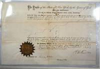
1847ref. 28447New York 1847. A certificate complete with seal signed by R. E. Fenton and Chauncey DePew. Hell Gate is a narrow part of the East River in New York City the phrase taken from the Dutch 'Hellegat.' The name refers to the whirlpool that results from the currents rocks and narrow channel and dangers to merchant travel through the area. Hell Gate Pilots were experienced and authorized by the state to navigate vessels through the channel. Reuben E. Fenton was a merchant and politician and governor of New York from 1865-1868. Chauncey Depew was an attorney businessman and politician as well as US Senator from New York. 16 3/8 x 10 3/4" cream paper original folds gold seal with manuscript additions and signatures with signed and stamped swearing in page for the County Clerk's Office in New York County 8 1/2 x 7" cream paper manuscript additions. Some folds are split with slt loss. Otherwise very good and an interesting piece of nautical history. unknown
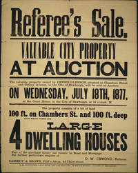
1877ref. 24402Newburgh NY: E. M. Ruttenber & Son 1877. Good condition. Large impressive broadside printed in a variety of type fonts for Hudson River property that is currently on the southern edge of the campus of Mount Saint Mary College and Bishop Dunn School. The broadside lists the owner as Dennis Glennon located at Chambers Street and Gidney Avenue Newburgh NY. Referee's Sale with Auction date Wednesday July 18th 1877 at the Court House in the city of Newburgh. The property is a lot measuring 100 X 100ft with 4 large dwelling houses D. W. Esmond Referee. Printed in black on yellow paper. Period folds some slt. holes at intersection of some folds a couple of crease separations short tear upper left corner repaired. 19 x 24". Not recorded in OCLC. E. M. Ruttenber & Son unknown
ref. elala2368Madrid: Francisco Xavier García 1771. First Edition. cfCamus-Dupin 2304 4th Edn. 4to. pp. 6 p.l. lxx cccxliv 1 leaferrata. woodcut title vignette & initial. paste-over cancel on Ss4v. contemporary mottled calf gilt back extremities worn wormhole in centre through first half more extensive worming in gatherings Q-Bb but no terrible loss of text institutional bookplate & rubberstamps on a2. some old ms. marginal notes Madrid: Francisco Xavier, García, 1771 unknown
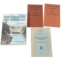
1933ref. 236831933. Colorado River development publications from 1933 to 1970 documenting the federal transformation of the river at a scale that continues to shape water rights regional growth and the ecology of the American West. The group traces the movement from basinwide stream measurement to large-scale storage hydroelectric generation irrigation municipal supply and industrial planning culminating in the construction of Glen Canyon Dam and the creation of Lake Powell. Together the publications record the governmental and technical systems that made extensive control of the Colorado River possible while noting the environmental consequences and increasingly contested allocation of a finite water supply. Group of six reports and illustrated brochures. 1 Grover Nathan C. et al. Surface Water Supply of the United States 1933. Part 9 Colorado River Basin. Washington: Government Printing Office 1935. Geological Survey Water Supply Paper 749 recording gaging stations and discharge across the Colorado River system. 2 Grover Nathan C. et al. Surface Water Supply of the United States 1937. Part 9 Colorado River Basin. Washington: Government Printing Office 1938. Geological Survey Water Supply Paper 829 with expanded records for Arizona Colorado New Mexico Utah and Wyoming. 3 Dietrich John W. and John T. Lonsdale. Mineral Resources of the Colorado River Industrial Development Association Area. Austin: Bureau of Economic Geology University of Texas 1958. Report of Investigations No. 37 surveying building stone limestone clay lignite salt sulfur and related resources in ten Texas counties. 4 United States Bureau of Reclamation. Colorado River Storage Project. Circa 1970. Illustrated brochure explaining interstate allocation irrigation municipal supply reservoirs and power financing. 5 United States Bureau of Reclamation. Colorado River Storage Project Power Operations Center Montrose Colorado. Circa 1970. Folding brochure describing the operation of storage units powerplants and approximately 1800 miles of transmission lines. 6 United States Bureau of Reclamation. Glen Canyon Dam and Powerplant: Technical Record of Design and Construction. Denver 1970. Extensively illustrated technical record with pencil annotations and page references concerning surveys diversion tunnels spillways dam elevations archaeology temperature records and construction chronology. The two Geological Survey volumes preserve the hydrological data used to quantify and divide the river before the era of major Upper Basin dams. The Glen Canyon record documents the engineering of one of the most consequential and controversial water projects in the American West whose reservoir inundated Glen Canyon and permanently altered downstream flow sediment movement temperature habitat and access to the river. The Texas mineral survey and Reclamation brochures place this development within a broader program of industrial expansion irrigated agriculture municipal growth and federally financed electrical infrastructure. Light to moderate wrapper wear toning rubbing and occasional staining; pronounced discoloration to the mineral report; extensive pencil annotation in the Glen Canyon volume. Overall good condition. The archive records the policies and engineering that reshaped the Colorado River with enduring relevance to environmental history water scarcity western development and the struggle over who controls and benefits from the region's water. unknown
1933ref. 236831933. Colorado River development publications from 1933 to 1970 documenting the federal transformation of the river at a scale that continues to shape water rights regional growth and the ecology of the American West. The group traces the movement from basinwide stream measurement to large-scale storage hydroelectric generation irrigation municipal supply and industrial planning culminating in the construction of Glen Canyon Dam and the creation of Lake Powell. Together the publications record the governmental and technical systems that made extensive control of the Colorado River possible while noting the environmental consequences and increasingly contested allocation of a finite water supply. Group of six reports and illustrated brochures. 1 Grover Nathan C. et al. Surface Water Supply of the United States 1933. Part 9 Colorado River Basin. Washington: Government Printing Office 1935. Geological Survey Water Supply Paper 749 recording gaging stations and discharge across the Colorado River system. 2 Grover Nathan C. et al. Surface Water Supply of the United States 1937. Part 9 Colorado River Basin. Washington: Government Printing Office 1938. Geological Survey Water Supply Paper 829 with expanded records for Arizona Colorado New Mexico Utah and Wyoming. 3 Dietrich John W. and John T. Lonsdale. Mineral Resources of the Colorado River Industrial Development Association Area. Austin: Bureau of Economic Geology University of Texas 1958. Report of Investigations No. 37 surveying building stone limestone clay lignite salt sulfur and related resources in ten Texas counties. 4 United States Bureau of Reclamation. Colorado River Storage Project. Circa 1970. Illustrated brochure explaining interstate allocation irrigation municipal supply reservoirs and power financing. 5 United States Bureau of Reclamation. Colorado River Storage Project Power Operations Center Montrose Colorado. Circa 1970. Folding brochure describing the operation of storage units powerplants and approximately 1800 miles of transmission lines. 6 United States Bureau of Reclamation. Glen Canyon Dam and Powerplant: Technical Record of Design and Construction. Denver 1970. Extensively illustrated technical record with pencil annotations and page references concerning surveys diversion tunnels spillways dam elevations archaeology temperature records and construction chronology. The two Geological Survey volumes preserve the hydrological data used to quantify and divide the river before the era of major Upper Basin dams. The Glen Canyon record documents the engineering of one of the most consequential and controversial water projects in the American West whose reservoir inundated Glen Canyon and permanently altered downstream flow sediment movement temperature habitat and access to the river. The Texas mineral survey and Reclamation brochures place this development within a broader program of industrial expansion irrigated agriculture municipal growth and federally financed electrical infrastructure. Light to moderate wrapper wear toning rubbing and occasional staining; pronounced discoloration to the mineral report; extensive pencil annotation in the Glen Canyon volume. Overall good condition. The archive records the policies and engineering that reshaped the Colorado River with enduring relevance to environmental history water scarcity western development and the struggle over who controls and benefits from the region's water. unknown books
1936ref. 233041936. Springfield Massachusetts flood photographs documenting the March 1936 Connecticut River disaster in western Massachusetts with direct evidence of how floodwater moved through streets bridges utility plants churches and commercial blocks in one of the worst flood events in regional history. Images record the city at the point where river flooding became an urban systems failure not only inundating homes and business districts but also interrupting power transport and street circulation in a manufacturing center already under Depression era strain. The 1936 flood in Springfield formed part of the larger New England catastrophe that left 15000 city residents homeless and pushed federal and local authorities toward new flood control measures including the broader post 1936 buildout of levees dikes and river management works under the Flood Control Act of 1936. Photo archive of 16 sepia photographs with printed captions on lower margin 3.25" x 4.75" Springfield Massachusetts 1936. The photographs are captioned beneath the image area with specific locations including "North Main St. Flood Scene" "Plainfield Street" "Flood Barricade Telephone Bldg." "St. James M.E. Church" "U. E. Light Power Plant" and "Railroad Bridge Conn. to name a few. Several views show entire streets turned into waterways with tree trunks porches and first floors standing in still floodwater. One Plainfield Street view shows two men navigating a rowboat between commercial buildings. The Telephone Building appears protected by sandbags stacked across low window openings showcasing emergency defense. The St. James M.E. Church photograph shows water standing nearly to the base of the windows around the church grounds. Memorial Bridge and the railroad bridge are both shown against a swollen Connecticut River while the riverfront and power plant views place industrial and utility structures at the flood edge. The Locust and Main Street image shows crowds boats automobiles and rescue activity gathered at a flooded intersection and the State Street at Main view shows a truck moving through deep water in the downtown business district. The South Main Street and South End views extend that disruption into retail and industrial blocks where storefronts sidewalks and roadbeds disappear under the flood. The flood followed a severe winter deep snowpack frozen ground and heavy March rain across the Connecticut River Valley. In Springfield and nearby West Springfield existing dikes were overtopped undermined and eroded while floodwater cut off neighborhoods and disabled normal traffic. The Connecticut River Valley was a manufacturing corridor the surrounding area was still recovering from the Great Depression; this economic downturn resulted in greater structural change. The disaster helped drive the Flood Control Act of 1936 and in West Springfield the U.S. Army Corps of Engineers began a local protection project in 1939 to enlarge and rehabilitate flood defenses completed in 1942. Light wear and mild toning; captions remain clear and the photographs present well. Overall very good condition. A visual documentation of the flood that forced Springfield to reshape the infrastructure of their river front environment. unknown
1936ref. 233041936. Springfield Massachusetts flood photographs documenting the March 1936 Connecticut River disaster in western Massachusetts with direct evidence of how floodwater moved through streets bridges utility plants churches and commercial blocks in one of the worst flood events in regional history. Images record the city at the point where river flooding became an urban systems failure not only inundating homes and business districts but also interrupting power transport and street circulation in a manufacturing center already under Depression era strain. The 1936 flood in Springfield formed part of the larger New England catastrophe that left 15000 city residents homeless and pushed federal and local authorities toward new flood control measures including the broader post 1936 buildout of levees dikes and river management works under the Flood Control Act of 1936. Photo archive of 16 sepia photographs with printed captions on lower margin 3.25" x 4.75" Springfield Massachusetts 1936. The photographs are captioned beneath the image area with specific locations including "North Main St. Flood Scene" "Plainfield Street" "Flood Barricade Telephone Bldg." "St. James M.E. Church" "U. E. Light Power Plant" and "Railroad Bridge Conn. to name a few. Several views show entire streets turned into waterways with tree trunks porches and first floors standing in still floodwater. One Plainfield Street view shows two men navigating a rowboat between commercial buildings. The Telephone Building appears protected by sandbags stacked across low window openings showcasing emergency defense. The St. James M.E. Church photograph shows water standing nearly to the base of the windows around the church grounds. Memorial Bridge and the railroad bridge are both shown against a swollen Connecticut River while the riverfront and power plant views place industrial and utility structures at the flood edge. The Locust and Main Street image shows crowds boats automobiles and rescue activity gathered at a flooded intersection and the State Street at Main view shows a truck moving through deep water in the downtown business district. The South Main Street and South End views extend that disruption into retail and industrial blocks where storefronts sidewalks and roadbeds disappear under the flood. The flood followed a severe winter deep snowpack frozen ground and heavy March rain across the Connecticut River Valley. In Springfield and nearby West Springfield existing dikes were overtopped undermined and eroded while floodwater cut off neighborhoods and disabled normal traffic. The Connecticut River Valley was a manufacturing corridor the surrounding area was still recovering from the Great Depression; this economic downturn resulted in greater structural change. The disaster helped drive the Flood Control Act of 1936 and in West Springfield the U.S. Army Corps of Engineers began a local protection project in 1939 to enlarge and rehabilitate flood defenses completed in 1942. Light wear and mild toning; captions remain clear and the photographs present well. Overall very good condition. A visual documentation of the flood that forced Springfield to reshape the infrastructure of their river front environment. unknown books
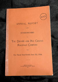
1906ref. 74THE DENVER & RIO GRANDE RAILROAD. 20th ANNUAL REPORT TO THE STOCKHOLDERS OF THE DENVER and RIO GRANDE RAILROAD COMPANY For The Fiscal Year EndeD June 30 1906 Denver Colorado: The Smith-Brooks Printing Company 1906 Original printed burnt orange wrappers front and back Very good plus to near fine condition; one small chips on lower margin of back cover; spine reinforced with special conservation tape; interior pages and map very good plus to near fine; several tiny splits in map folds conserved. Publication dimensions:6 inches by 8-7/8 inches46 pages Map dimensions:20 inches by 15 inches COLORADO ARTIFACTUAL The Smith-Brooks Publishing Co. paperback
1934ref. 158567N.p.: N.p. 1934. Vintage photographic print of a portrait of Mexican-American actress Dolores del Rio circa 1933-1934 created by painter and film director Hugo Ballin. Stamp of photographer Clyde Stoughton on the verso along with the stamp of Acme Engraving Company and annotations in manuscript pencil regarding cropping. New York-born artist and muralist Hugo Ballin began working for Goldwyn Studios in 1917 in New Jersey as an art director and production designer moving to Los Angeles in 1921 at the request of Samuel Goldwyn. He enjoyed a brief career as a director writer and producer of silent films but decided to return to painting upon the advent of sound films. He is best remembered for his murals many of which still stand today throughout Los Angeles. 8 x 10 inches. Very Good lightly edgeworn and age toned with a short closed tear at the top edge. N.p. unknown
1934ref. 158567N.p.: N.p. 1934. Vintage photographic print of a portrait of Mexican-American actress Dolores del Rio circa 1933-1934 created by painter and film director Hugo Ballin. Stamp of photographer Clyde Stoughton on the verso along with the stamp of Acme Engraving Company and annotations in manuscript pencil regarding cropping. New York-born artist and muralist Hugo Ballin began working for Goldwyn Studios in 1917 in New Jersey as an art director and production designer moving to Los Angeles in 1921 at the request of Samuel Goldwyn. He enjoyed a brief career as a director writer and producer of silent films but decided to return to painting upon the advent of sound films. He is best remembered for his murals many of which still stand today throughout Los Angeles. 8 x 10 inches. Very Good lightly edgeworn and age toned with a short closed tear at the top edge. N.p. unknown books
1879ref. 89341Paris: Au siège de la société d'acclimatation 1879. Fine. Au siège de la société d'acclimatation Paris 1879 17.5 x 28 cm Relié First edition illustrated with 62 figures in the text or full-page included in the pagination.Half green oasis morocco spine with five raised bands marbled paper sides endpapers and pastedowns of marbled paper original wrappers and spine preserved top edge gilt modern binding signed Laurenchet.A few small spots of foxing manuscript ex-dono at the head of the front wrapper.A pleasing copy. Au siège de la société d'acclimatation hardcover
1984ref. 48501Paris: Gallimard 1984. Fine. Gallimard Paris 1984 15 x 22 cm broché First edition of the French translation one of 20 numbered copies on Hollande tirage de tête. A very good copy. Gallimard unknown
1867ref. 50353J. Rotschild, éditeur 1867 In-4 27,5 x 17 cm. Reliure demi-maroquin cerise, dos à nerfs, caissons ornés à froid de motifs floraux, X- 286 pp. 75 planches lithographiées en couleurs sous serpente, 112 figures. Très légèrs frottements. Infimes rousseurs.
ref. DADAX1421500663New unknown
2006ref. 2111902152907768Chusekisha 2006. Soft Cover. Fine. Size: 179x120mm Number of books: 18 books in total Chusekisha paperback
1679ref. 93517Lugduni, Joannis-Antonii Huguetan, & soc. 1679 In-folio 36 x 23 cm. Reliure de l’époque plein veau havane marbré, dos à nerf encadrés de fers dorés, sans pièce de titre, 10-604-32 pp., texte sur 2 colonnes, page de titre avec vignette gravée, bandeaux, lettrines. Reliure fatiguée, coins émoussés, manque frontispice, manque angulaire sur les 5 derniers feuillets de l’index, annotations de l’époque en dernière page de garde, intérieur correct. En l’état.
ref. DADAX0870813013New unknown
2010ref. 47950Robert Laffont Couvertures souples Paris 2010
2024ref. __1071923609Cq Pr 2024. Hardcover. New. 800 pages. 10.25x7.50x1.75 inches. Cq Pr hardcover
1909ref. 60789Milwaukie OR: Elvah Reck & Albert Reck 1909-1910. Tall 8vo. 6 x 9 in. 88 pp unpaginated. on blue ruled paper first 26 pp. filled out in two different manuscript hands in ink & pencil first part by Elva remainder by Albert of approx. 4500 words. Limp tan covers cloth backing & stapled at upper fore-edge center crease from folding to insert into backpack Arts & Crafts decorative borders light age toning still a VG exemplar. A concise and informative travel diary written by Elvah Reck and her husband Albert Reck a street car conductor for the PRL&P Co. and enthusiastic semi-professional photographer as they traveled on the ever-expanding railway network in and around Portland Oregon during the Progressive Era. Elvah notes that on the night before the family was to travel up the Columbia River Gorge “Bert came home at 1:16 AM developed negative of Oak Grove base ball boys and made preparations for the morning and retired at 3 AM.” Subsequently Bert and family overslept by an hour and raced to catch the train and managed to board the Baily Gatzert sternwheeler by 7:00 AM. “Bert took a picture of Rooster Rock and two pictures of Cape Horn.” Elvah makes frequent mentions of the beauty of the Columbia River and surroundings and was fascinated by the working of the Cascade Locks. They left the sternwheeler and packing three children their belongings and camera equipment they secured a camping spot. However their daughter Norma climbed on an old stump to get a better view and “put her foot in a yellow-jacket nest and the way she climbed down from there and screamed was enough to bring everyone from the other camps . . . we fought yellow-jackets and ran a half mile to keep up with Norma.” The family does manage to find an abandoned house to camp in manage their breakfast and then hike and travel along the rim into Oneonta Gorge and decided later to return back home “on account of Elvah’s back.”Reck records one of his many photo shoot excursions when on April 3 1910 he takes off with fellow enthusiast and machinist Ed Leppert to take photos at Cazadero OR at the time a stop on the Estacada Interurban Railway Line of the PRL&P Co. catching Train No 62 shot logging pictures below Boring OR and then fishing near the Clackamas River at Eagle Creek OR. Leppert 1867-1934 was a fellow Ohioan at the time working for PRL & P Co. as well as in the Albina shipyards and 3 years later moved to Ogden UT before returning to Portland. Aug. 28 1910 they took Ed along with the family for a week vacation at Seaside OR after loading the camera “and all manner of junk into one back-pack two baskets and a suitcase.” Once again the family was running late missed the connection and barely made Union Station in time to catch the 9:15 train on the Astoria & Columbia Railway to Seaside in three hours along the scenic River. Bert writes they secured a “Furnished Tent” for $ 7.00 for the week and began shooting photos along the beach of the bathers the ocean the Hotel Moore and the breakers and did some crab fishing. One of the days the sun was out so Ed and Bert “loaded up our stereo camera & tripod and started down the beach.” They trekked along the sand and rocks “watched a number of porpoises or ‘sea hogs’ sporting in the Ocean a short distance off shore. . . and wished for a telephoto lens.” By the time the pair had lugged their camera to the lighthouse the fog had rolled in obscuring the scenery. Elva Reck 1877-1955 according to census records and street directories had opened a “Racket Store” by 1920 which she operated for a few years. Bert Reck 1877-1972 had moved his family from Ohio by 1903 where he began a lifelong career as a streetcar motorman as well as shooting and selling photos of hikes on Mt. Hood digging clams visiting Nye Beach in Newport Depoe Bay and other areas around the PNW. He frequently took photos along the line he ran from Sellwood to Cazadero to the dam. See: History of Estacada Faraday and Cazadero Oregon Pacific Northwest Photoblog Aug. 7 2014; Portland Railway Light & Power Co. Interurbans PDXHistory 2017. Elvah Reck & Albert Reck, hardcover
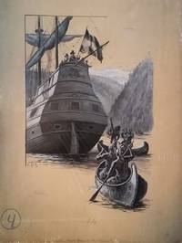
1895ref. 163631895. Painting. Very good overall. Shute was a well known illustrator from Brookline Mass. who worked for Stratemeyer until his death in 1906. This is a gouache on stiff board illustration in shades of black and white depicting Native Americans in canoes approaching Henry Hudson's Half Moon. Signed at the left A. B. S. and with two spaces at the lower left and upper right and marked mortise in pencil. Image size 10 1/4 x 16". Paperboard size: 15 x 20 unknown