|
[LEBECK (Robert)].-
Le Baiser. 80 cartes postales anciennes rassemblées et publiées par Robert Lebeck. Postface de Jurgen Kesting.
1981 Paris, Duculot, 1981, in 12 broché, 174 pages ; couvetrure illustrée.
Bookseller reference : 75568
|
|
|
[LILLE]
Plan de Lille, de la citadelle, et de ses environs.
A Paris, chez le sieur Le Rouge, s.d. 67 x 54 cm.,
Bookseller reference : 175648
|
|
|
[LILLE] FRICX (Eugène Henry).
Présenté à S.A.S. Monseigneur le Prince Eugène de Savoye. Plan de la citadelle de Lille.. Laquelle, après que la Ville fut prise le 22 octobre, on a aussi commencé d'attaquer sous le commandement de S.A. le Prince Eugène de Savoye dès le 29 [...]
Bruxelles, Eugène Henrÿ FRICX, 1709 sans les marges : 42 x 54 cm - cadre : 60.5 x 70.5 cm, cadre contemporain à baguettes. Pliure centrale. Quelques taches.
Bookseller reference : 230822

|
|
|
[LORRAIN] - TEXIER (Fabienne)
Metz il y a 100 ans.
Prahecq, Éditions Patrimoines et Médias, 2010; in-4 oblong, 140 pp., cartonnage imprimé d'éditeur. Oeuvre illustrée en cartes postales anciennes, photographiées et en couleur. Iconographie des archives municipales de Metz avec la participation du maire de Metz Dominique Gros.
|
|
|
[LORRAIN] - TEXIER (Fabienne)
Metz il y a 100 ans.
Prahecq, Éditions Patrimoines et Médias, 2010 ; in-4 oblong, 140 pp., cartonnage imprimé d'éditeur. Oeuvre illustrée en cartes postales anciennes, photographiées et en couleur. Iconographie des archives municipales de Metz avec la participation du maire de Metz Dominique Gros.
Bookseller reference : _202100367

|
|
|
[LYONNAIS].-
Cartes du Ministère de l'Intérieur au 1/100.000e. LYON en 4 cartes (Sud-Est - Sud-Ouest - Nord-Est - Nord-Ouest) présentées repliées en 4 portefeuilles rouges au format 10X16. Edités par la librairie Hachette dans les tirages de 1898-1900.
Bookseller reference : 56101
|
|
|
[Manche - Traversée de la]
Carte du pont sur la Manche.
Avant-projets présentés par Schneider et Cie (du Creusot) et H. Hersent à l'Exposition Internationale de Paris en 1889 (94 x 32 cm), lithographiée en couleurs.
Bookseller reference : 10845
|
|
|
[MANUSCRIT]
Carte figurative de la seigneurie de Beaufremez. appartenant au Sr. Gille Le Cat seigneur dudit Beaufremez, Clicquenoy, et., situé ès paroisses de Bondue [Bondues], Marcq [-en-Bareul], et environ, dont l'explication et grandeurs de chaque partie de terre avecq les tenans et aboutissans se trouve par l'acte jointe [sic], fait par le soubsigné arpenteur juré, et arresté le trentiesme de may mil sept cent dix-huit
S.l.n.d. (1718) grande carte in-4 oblongue (37 x 82 cm), contours rehaussés de couleurs, avec une échelle en verges dans le coin droit, en feuille. Traces de mouillures, petit manque de papier sans gravité.
Bookseller reference : 190576
|
|
|
[MANUSCRIT]
Projet d'attaque d'une place étrangère.. Fait et dessinné [sic] par le sous-lieutenant élève d'artillerie Demarçay. Autographié par Em. Baur
Fontainebleau, 31 janvier 1876 in-folio oblong (68 x 96 cm), en feuille, bord supérieur ébarbé.
Bookseller reference : 208488
|
|
|
[Map - Saudi Arabia - Jordan].
USAF aeronautical chart and information service. World aeronautical chart (446) Wadi Sirhan. Washington, D.C., AAF Aeronautical Chart Service, 1945.
Colour-printed map, 730 x 560 mm. Scale 1:1,000,000. On verso: legend, aeronautical information, and index map. First edition. - Pilot's map of Wadi Sirhan in the border region of Iraq, Saudi Arabia and Transjordan. It shows international boundaries populated places, roads and tracks, railways, wireless telegraph stations, forts, wadis, wells, vegetation and terrain features. Shows also parts of Transjordan and Iraq, including the zigzagging border between Saudi Arabia and Transjordan. - In excellent condition.
|
|
|
[Map of Arabia.] Brion de la Tour, Louis.
Perse, Turquie Asiatique et Arabie. Paris, Louis Charles Desnos, 1799.
Engraved map in original outline colour. Flanked by two mounted columns of French text. Very fine map of Arabia by the “Ingénieur-Geographe du Roy” Louis Brion de la Tour (1756-1823) showing Turkey, Palestine, present-day Iraq and Iran, the Caucasus region as well as the Arabian Peninsula. Cf. National Maritime Museum Cat. I, 264. Not in Al Ankary; Al-Qasimi.
|
|
|
[Mappa Mundi - Africa and Asia].
Hand-drawn map of the Southern Hemisphere. No place, 17th or early 18th c.
Ca. 195 x 293 mm. Ink on vellum primed with gesso, annotated in Latin. An early map of Africa and Asia south of the Equator, Indonesia largely obscured by a defect to the upper right corner. Tristan da Cunha is identified, as well as the Antarctic Circle. The map also shows the hypothetical southern continent Terra Australis Incognita, merging into New Guinea at the very right edge of the vellum sheet. The "unknown land of the south" was first posited in antiquity and appeared on maps between the 15th and 18th centuries before its existence was finally disproven by the voyages of James Cook, which instead established the existence of Australia more or less in its place. - Ink rather faint in places. Surface slightly rubbed; some wrinkling and creasing; loss to upper right corner (ca. 6 x 3 cm).
|
|
|
[Medina - Al-Ula].
Medina. World (Asia) 1:1,000,000. Series 1301. Edition 4-GSGS. Sheet NG-37 & part NG-36. [London], War Office and Air Ministry, 1960.
Colour printed map, ca. 810 x 608 mm. Scale: 1:1,000,000. Shows boundaries, highways and roads, railways, rivers and water features, and other details. Rare 4th GSGS edition of this map of Saudi Arabia, as part of the International Map of the World series, showing the western coastline as well as the cities Medina and Ha'il and the oasis of Al-Ula in the interior. - Stamp of ownership of Arizona State University, along with "withdrawn" and "superseded" stamps on top and next to it. - 56 mm piece of adhesive tape on top edge; pencil marks to lower right corner. OCLC 634944590. Cf. OCLC 35899626 (1962 ed.).
|
|
|
[MERVEILLEUX Charles Frédéric]:
Mémoires instructifs pour un voyageur dans les divers Etats de l'Europe: contenant des anecdotes curieuses trés propres à éclaircir l'histoire du tems; avec des remarques sur le commerce & l'histoire naturelle.
Amsterdam, H. du Sauzet, 1738. 2 tomes en un volume in-12 de [8]-228; [4]-241-[3] pages, plein veau brun, dos à nerfs orné de filets et fleurons dorés, pièce de titre beige, roulette dorée sur les coupes, tranches rouges. Coins à peine frottés, tache d'encre p. 63 du tome 2.
Bookseller reference : 8764

|
|
|
[Michelin]
CARTE MICHELIN N° 328 : AIN, HAUTE-SAVOIE
Une carte géographique "Local" au 1:150.000e, éditée en 2004, bon état
Bookseller reference : LFA-126744324
|
|
|
[Middle East] - Gaebler, Eduard.
Vorder-Asien. Leipzig, [1892].
254 x 201 mm. Lithographed map. Scale 1:25,000,000. Gilt wooden frame (290 x 357 mm). Political map of the Middle East prior to WWI, detailing the Arabian Peninsula, the Gulf, Iran, and the Ottoman Empire, as well as parts of Africa, Russia and China. Among the labelled cities on the Gulf are Sharjah, Al-Wakrah and Manamah. With 4 inset maps showing Palestine (1:2,500,000) and Jerusalem with its surroundings (1:500,000) as well as the southern German states and Lake Constance for scale. - Early edition of Eduard Gaebler's map of western Asia, published published in "Neuester Hand-Atlas über alle Teile der Erde" (Leipzig, Gaebler's Geographisches Institut, 1892). The map saw numerous reissues; a revised edition appeared in Gaebler's "Kleiner Handatlas" as late as 1933. - Slight foxing. Frame shows some traces of worming; tiny piece of wood chipped near left margin. An appealing map in an attractive wooden frame with a gilt border.
|
|
|
[Miroir de l'Histoire]
MIROIR de l'HISTOIRE n° 169 Janvier 1964
Une revue de 110 pages, format 170 x 230 mm, illustrée, brochée
Bookseller reference : LFA019c5
|
|
|
[N. A.].
[OTTOMAN MILITARY MAP of PATAGONIA and FALKLAND ISLANDS: ROUTE of DRESDEN] Alman kruvazörü Dresden'in takîbi ve tahrîbi.
Very Good Turkish, Ottoman (1500-1928) Original color map. Elephant folio. (59x75 cm). In Ottoman script. [OTTOMAN MILITARY MAP of PATAGONIA and FALKLAND ISLANDS: ROUTE of DRESDEN] Alman kruvazörü Dresden'in takîbi ve tahrîbi. SMS Dresden cruiser's routes between 1913-1915 (World War 1) on the Patagonian shelf; western shores of South America, Patagonia and Falkland Islands. Dresden spent much of her career overseas. After commissioning, she visited the United States in 1909 during the Hudson-Fulton Celebration, before returning to Germany to serve in the reconnaissance force of the High Seas Fleet for three years. In 1913, she was assigned to the Mediterranean Division. She was then sent to the Caribbean to protect German nationals during the Mexican Revolution. In mid-1914, she carried the former dictator Victoriano Huerta to Jamaica, where the British had granted him asylum. She was due to return to Germany in July 1914, but was prevented by the outbreak of World War I from doing so. At the onset of hostilities, Dresden operated as a commerce raider in South American waters in the Atlantic, then moved to the Pacific Ocean in September and joined Maximilian von Spee's East Asia Squadron. Dresden saw action in the Battle of Coronel in November, where she engaged the British cruiser HMS Glasgow, and at the Battle of the Falkland Islands in December, where she was the only German warship to escape destruction. She eluded her British pursuers for several more months, until she put into Robinson Crusoe Island in March 1915. Her engines were worn out and she had almost no coal left for her boilers, so the ship's captain contacted the local Chilean authorities to have Dresden interned. She was trapped by British cruisers, including her old opponent Glasgow. The British violated Chilean neutrality and opened fire on the ship in the Battle of Más a Tierra. The Germans scuttled Dresden and the majority of the crew escaped to be interned in Chile for the duration of the war. The wreck remains in the harbor; several artifacts, including her bell and compass, have been returned to Germany.
|
|
|
[Palestine].
Situs Terrae Promissionis SS Bibliorum Intelligentiam Exacte Aperiens: Per Christianum Adrichomium Delphum". Cologne, Kramer, 1682.
Engraved map, printed from two plates and assembled. Ca. 1065 x 390 mm (printed area ca. 1005 x 350 mm). Large and decorative map of the Holy Land, printed from two plate, from Christian van Adrichem's "Theatrum terrae sanctae et biblicarum historiarum". Van Adrichem's map is oriented toward the east and shows the twelve tribes of Israel on both sides of the River Jordan. The coastline runs from Sidon in Lebanon to Alexandria in Egypt, also showing part of the Red Sea. In the Mediterranean, off the coast, several ships and sea monsters are visible. On the Dead Sea are four burning cities: Sodom, Gomorrah, Zeboim, and Adama. - Folds smoothed and reinforced in places. A good, strong impression.
|
|
|
[PARIS]
Album de cartes et vues de Paris
Paris, début du XXe siècle. In-8, 46 pl., chagrin brun d'Antoine Maître, décor à froid sur les plats et le dos, tranches dorées (épidermures, fermoirs manquants).
Bookseller reference : 19206

|
|
|
[Patrimoine en Isère]
CARTE MATHEYSINE
Une carte géographique au 1:100.000e, éditée en 2008, bon état
Bookseller reference : LFA-126728944
|
|
|
[Paul VI]:
Visite du Pape Paul VI à la conférence internationale du Travail, Genève 10 juin 1969.
Enveloppe avec décor gaufré, timbre spécial édité à l'occasion de la visite papale, oblitéré à la date de la conférence. En parfaite condition.
Bookseller reference : 4579

|
|
|
[PHILIPPINES] [CARTES POSTALES ANCIENNES] [OLD POSTCARDS]
Cartes Postales anciennes des Philippines
Manila, Camera Supply Co., sans date (ca 1910) 1 set of 11 postcards on Philippines Islands life and scenery, detached from a booklet, no stamp, in good condition.
Bookseller reference : 12029
|
|
|
[Photographie - Rom].
Roma. [Rom, um 1900].
36 Albuminabzüge (ca. 12:17 cm), montiert in rotes Originalleinenalbum mit goldgepr. Deckeltitel. Gr.-qu.-8vo. Schöne, teils etwas ausgebleichte Originalphotographien römischer Baudenkmäler um 1900, darunter Petersdom, Lateranbasilika, S. Maria Maggiore, Colosseum, Titusbogen, Forum romanum, Pantheon, Vestatempel, Trevibrunnen, Engelsburg, Piazza Navona, Trajanssäule, Cestiuspyramide und Statuen aus den Vatikanischen Sammlungen (Laokoongruppe, Perseus etc.). - Schwach wellig verzogen.

|
|
|
[PHOTOGRAPHIE].-
L'Artiste Photographe.-
ND Photo. Série des Scènes Parisiennes. (Vers 1905). Carte postale (14x9cm) ayant voyagé, oblitération de 1906. Tout petit défaut à un coin sinon bon état. Rare.
Bookseller reference : ORD-8404
|
|
|
[PICQUET (Charles)].
Plan routier de la ville de Paris. ou Guide des étrangers dans cette capitale, divisé en XII arrondissements ou mairies, et en 48 quartiers, offrant Paris tel qu'il est aujourd'hui, avec les noms des rues, quais, places, &c., inscrits conformément aux ordonnances royales
Paris, Ch. Picquet, 1833 plan dépliant de 59 x 89 cm, en feuilles, entoilées.
Bookseller reference : 227567

|
|
|
[PLAN - PARIS] DELAGRIVE (Jean), BAILLEUL (Nicolas dit le Jeune). (D'après)
Paris et ses environs..
(Fin du XIXème siècle), 60 x 87 cm (cuvette) - 68 x 100 cm (feuille), Pliures. Signature de Nicolas Bailleul effacée.
Bookseller reference : 232333

|
|
|
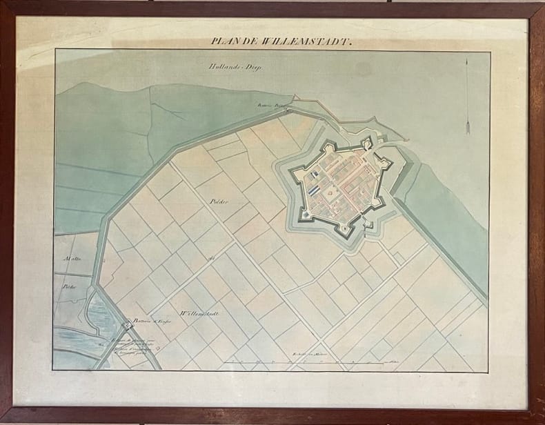
[PLAN MANUSCRIT]
Plan de Willemstadt.
(XVIIIème siècle) 48.5 x 63.5 cm (à vue) - 52.5 x 68 cm ( cadre) , cadre en bois verni. Déchirures dans la partie supérieure n'atteignant pas la composition. Insolé.
Bookseller reference : 232205
|
|
|
[PLAN MANUSCRIT] ROCHETTE, BOISLISLE, CORTEZ.
Fort de France.. les travaux utilisés sont de M.M. les enseignes de Vaisseau de 2ème classe - Croiseur Suffren
Novembre-Décembre 1930 à vue : 50 x 31 cm - cadre : 53 x 34 cm , cadre en bois verni d'époque. Rousseurs.
Bookseller reference : 231856

|
|
|
[PLAN-PARIS] BERTHIER (Alexandre).
Carte topographique des environs de Versailles dite des chasses impériales.
Picquet, (ca. 1810), 46 x 80.5 cm (cuvette) - 55.5 x 82 cm (feuille) , Légères rousseurs. Petite déchirure n'atteignant pas la composition.
Bookseller reference : 232345
|
|
|
[PLAN]
Nouveau plan routier de la ville et faubourgs de Paris.
Paris, Esnaut et Rapilly, 1776 grand plan dépliant de 54 x 82 cm, en feuilles, entoilées, deux déchirures latérales aux pliures.
Bookseller reference : 210556
|
|
|
[PLAN]
Plan routier de la ville et faubourg de Paris.
Paris, Lattré, 1775 carte dépliante de 55 x 76 cm repliée au format in-8, en feuilles, entoilées, petits trous à certaines pliures, une tache au niveau du faubourg Saint-Antoine.
Bookseller reference : 210292

|
|
|
[PLAN]
Plan routier de la ville et fauxbourgs de Paris. divisé en douze mairies. Revu et corrigé par Hérisson, géographe
Paris, Jean, 1832 carte dépliante de 61 x 89 cm, contours rehaussés de couleurs, en feuille, bords très ébarbés, quelques salissures.
Bookseller reference : 210295
|
|
|
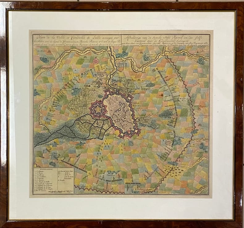
[PLAN] VISSCHER (Nicolaes Janz).
Plan de la Ville et Citadelle de Lille,. assiégée par les Alliez avec les lignes de Circumvalation, Approches, Bateries et le nom de chaque Régiment - Afbeeldinge van de stercke stad Ryssel en des felfs Kasteel door de Geallieerde beleegert, met haar linie van circumvalatie, aproches, battaryen en de de Naamen van jder regement. Le tout dessigné au naturel par un fameux Ingénieur. La tranchée fut ouverte le 22 aout 1708 alles door een voornaamen ingenieur, naa t leven geteekent, de Frencheen zyn den 22 August : 1708 geopent.
[Amsterdam], [1708] 49 x 53.5 (cuvette) - 68 x 73 cm (cadre), encadrement contemporain en bois verni. Quelques pliures. Infimes taches.
Bookseller reference : 231959
|
|
|
[PLAN].
Nouveau plan illustré de la ville de Paris. indiquant les changements, les voies projetées et en cours d'exécution
Paris, Imprimerie Monceau, 1867 plan dépliant de 59 x 89 cm, en feuille. Des déchirures à plusieurs pliures.
Bookseller reference : 227571

|
|
|
[PLANS DE PARIS].
Plant et pourtrait de la ville, cité et université de Paris.. Introduction et notes par l'abbé Valentin Dufour
Collection Anciennes descriptions de Paris, VIIIParis, A. Quantin, 1883 petit in-8, [2] ff. n. ch., LXXXIII pp., 53 pp., un f. n. ch. de table, avec 3 plans dépliants hors texte, broché.
Bookseller reference : 227357

|
|
|
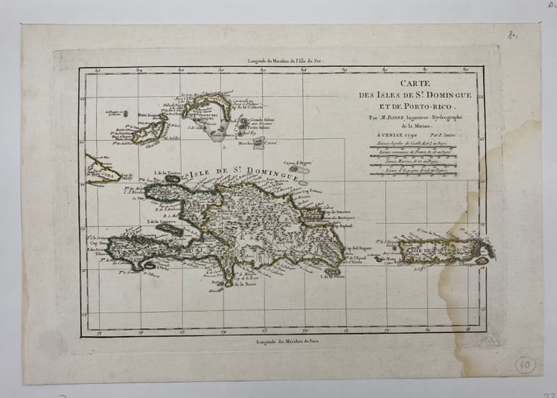
[PORTO-RICO/SAINT-DOMINGUE] BONNE (Rigobert).
Carte des Isles de St Domingue et de Porto-Rico.
Venise, (c.1790), , Mouillure sur le côté droit.
Bookseller reference : 231866
|
|
|
[Pro Juventute]:
Reproductions de timbres Helvetia, 1921 à 1926.
6 cartes présentant 6 timbres de la série Helvetia, Pro Junventute, de 1921 à 1926. Format des reproductions 15 x 18 cm.
Bookseller reference : 16617

|
|
|
[Ptolomaeus, Claudius]. - Sanz, Carlos
La Geographia de Ptolomeo. Ampliada con los primeros mapas impresos de América (desde 1507). Estudio bibliografico y critico. Con el catalogo de las ediciones aparecidas desde 1475 a 1883. Comentado e ilustrado.
Madrid, Victoriano Suarez, 1959. 4°. Mit zahlr. meist ganzs. Abbildungen. 281 S., 2 Bll., Lwd. d. Zt. m. goldgepr. Rückentitel u. dem eingeb. OUmschlag.
Bookseller reference : 48400

|
|
|
[Qatar - Bahrain - El Katif].
Hofuf. World 1,000:000. Series 1301. Edition 5-GSGS. Sheet NG39. [London], War Office and Air Ministry, 1963.
Colour-printed map, ca. 750 x 610mm. Scale: 1:1,000,000. Rare 5th GSGS edition of this map of Qatar, Bahrain, and Ras Tanura in Saudi Arabia, as part of the International Map of the World series. Depicts Saudi Arabia from As Saffaniyah in the North over Hofuf, to Hidiba in the South. Shows boundaries, highways and roads, railways, airports, rivers and water features, and other details. - Two small brown spots to the image and a nick to the top edge, some creasing near margins. OCLC 34907145.
|
|
|
[REIMS] COLIN (Jean).
Plan de la Ville Cité et Université de Reims.
Jamas, s.l., 1655 (1930-32). Grand plan divisé en 4 feuilles de 39 x 72 cm chacune. Quelques taches et une petite déchirure en marge.
Bookseller reference : 14136

|
|
|
[Reinegg, Jacob]
Tabula Itineraria a Sues usque ad Dsjabbel el Mokatteb et Montem Sinai. [Bildinschrift: Báhhr el Kolsum s. Báhhr es Sues; Báhhr el Akaba]. Kupferstichkarte mit Titelkartusche, Windrose u. 2 Meilenzeigern.
Kopenhagen, André Philippe de Pretot, 1772. Blattmaß 28 x 40 cm; Bildmaß 18 x 28,5 cm.
Bookseller reference : 78798
|
|
|
[ROCHAMBEAU, Jean-Baptiste Donatien, de Vimeur comte de].
I. « Plan des ville, citadelle, forts et port de Calais »; II. Cassini. Carte particulière des environs de Lille, Tournay, Valenciennes, Bouchain, Douay, Arras, Béthune. 1745.
[I. France, circa 1780]. II. Bruxelles, chez George Fricx, rue de la Madeleine, imprimeur. 1745. 1780 I: 1 feuille de 1 102 mm par 511 mm, tracée à l'encre et aquarellée ; II: 1 feuille de 420 mm par 456 mm, imprimée en noir. Les deux sont contrecollées sur toile. Cartonnage-étuis d'époque à rabats.
Bookseller reference : 4944

|
|
|
[RONDEAUX DE SETRY] LOYER.
Plan de la Ville de Rouen renfermée dans sa 1ère enceinte comme elle était sous Raoul et nos premiers ducs qui l'augmentèrent beaucoup du coté du midi et ressérèrent le lit de la rivière de près d'un tiers.
s.d. (XIXème). Plan manuscrit aquarellé (41 x 26 cm), légende des lieux en marge.
Bookseller reference : 13279

|
|
|
[RONDEAUX DE SETRY] RENAUD (C. R.).
Rouen au X & au XIe Siècle.
1882. Plan manuscrit aquarellé (55 x 35 cm), nombreuses annotations manuscrites reprises sur le plan original.
Bookseller reference : 9933

|
|
|
[RUCHAT Abraham; THURNEYSEN Emanuel; STANYAN Abraham; ALTMANN Johann Georg:
Etat et délices de la Suisse ou Description historique et géographique des treize cantons suisses et de leurs alliés. Nouvelle édition, corrigée & considérablement augmentée par plusieurs auteurs célèbres, & enrichie de figures en taille douce & de cartes géographiques.
A Neuchâtel, chez Samuel Fauche, 1778. 2 volumes in-4 de [4]-454-[2] et [4]-388 pages, demi-basane blonde, dos lisses ornés de roulettes, filets, fleurons, titre et tomaison dorés, étiquettes de titre et tomaison rouges, tranches jaunes. Dos un peu frottés, mors du premier volume fendu en queue sur 5 cm., premières charnières faibles, un cahier très légèrement déboîté.
Bookseller reference : 10246
|
|
|
[sans auteur] - RIQUETTI [ou RIQUETI] (Victor, Comte de MIRABEAU).
Atlas de la monarchie prussienne [sous Frédéric le Grand].
A Londres, s.é. [Lejay], 1788. Un fort vol. au format in-folio (433 x 277 mm) de 3 ff. n.fol., [10] cartes gravées sur double-page,, 93 planches gravées + tableaux et 1 f. bl. Ne subsiste plus de la reliure que le carton des plats.
Bookseller reference : 26048

|
|
|
[sans auteur].
Petit atlas national des 86 départements de la France et de ses colonies.
(Paris), Blaisot, 1835. Un fort vol. au format pt in-4 (263 x 182 mm) de 1 titre-frontispice n.fol. et [99] planches gravées sur double-page. Reliure de l'époque d edemi-basane glacée sapin, dos lisse orné de doubles filets dorés, larges fleurons romantiques dorés, titre doré.
Bookseller reference : 26317

|
|
|
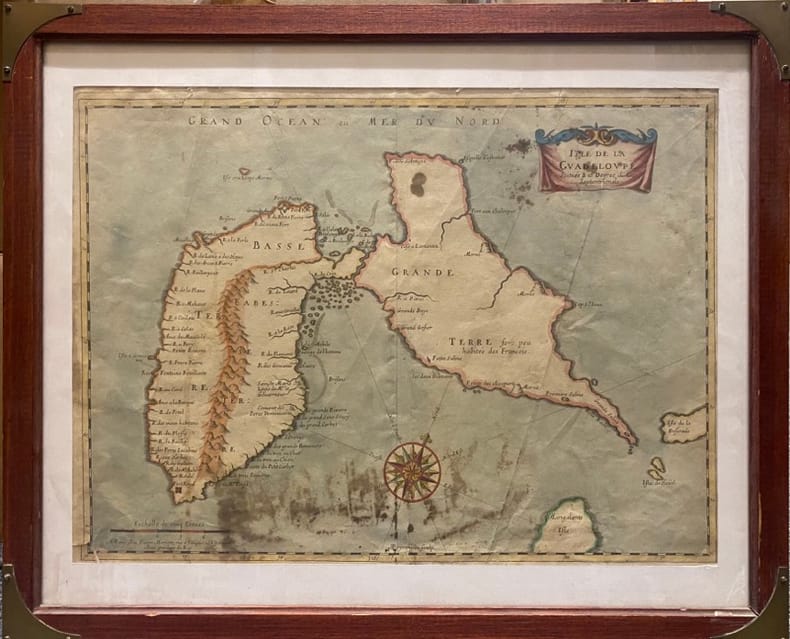
[SANSON D'ABBEVILLE (Nicolas)].
Isle de la Guadeloupe.. Scituée à 16 degrez de Lat .Septentrionale. A Paris chez Pierre Mariette, rue S.Iacques à L'Espérance. Avec Privilège du Roy
Paris, MARIETTE Pierre, (vers 1662) à vue : 32 x 43,5 cm - cadre : 43 x 52.5 cm , Cadre du XXe siècle. Déchirures dont une au coin inférieur gauche et une au niveau inférieur de la pliure centrale. Taches.
Bookseller reference : 230537
|
|
|
[Saudi Arabia and Yemen].
Collection of USAF Aeronautical Charts. Washington, DC, Army Map Service, 1942 and 1944.
8 charts. 560 x 735 mm, with key printed on the back. Scale 1:1,000,000. Substantial set of first edition U.S. pilot charts from the Second World War. Includes 2 maps of the Arabian Peninsula (668 and 669), depicting the border region of Saudi Arabia, Yemen and the Aden Protectorate and covering the area between the 42nd and 54th meridian east, and between the 16th and 20th parallel north. Also shows the Frasan Islands as well as large parts of the Rub' al Kahli desert with sections marked "unexplored", the city of Salala constituting the easternmost point. - Further, two maps of Iran (429 and 443) between the 53rd and 60th meridian east, and the 28th and 36th parallel north, identifying Kerman, Yazd and Birjand. - The remaining maps cover western Afghanistan (439), labelling Herat and Farah, central India (559), with cities such as Jabalpur, Bhopal and Achalpur, and the Indian Ocean showing the Chagos archipelago (1037) and Comoro Island (1052). - Chart no. 1037 dampstained with loss to the centre, chart no. 669 lacks approx. 5.5 cm, clipped away at upper margin. Remaining maps with occasional small tears, but overall in good condition.
|
|
 Receive by email
 Download as PDF document
 RSS feed


