|
[GRAVURE] - CARTE
Mappemonde en deux hémisphères.
Paris, Delamarche, 1838 ; 336/475 mm, 1 pp., une feuille. Mappemonde. Bon état.
Bookseller reference : A102
|
|
|
[GRAVURE] - CARTE
Monde connu des anciens.
Paris, Delamarche, 1838; 336/475 mm, 1 pp., une feuille. Carte historique reconstitution des mondes connus et des populations que ces mondes hébergent. Bon état.
|
|
|
[GRAVURE] - CARTE
Monde connu des anciens.
Paris, Delamarche, 1838 ; 336/475 mm, 1 pp., une feuille. Carte historique reconstitution des mondes connus et des populations que ces mondes hébergent. Bon état.
Bookseller reference : A103
|
|
|
[GRAVURE] - CARTE
Norvège, Suède et Danemark.
Paris, Delamarche, 1838; 475/336 mm, 1 pp., une feuille. Carte ancienne des pays scandinaves. Bon état.
|
|
|
[GRAVURE] - CARTE
Norvège, Suède et Danemark.
Paris, Delamarche, 1838 ; 475/336 mm, 1 pp., une feuille. Carte ancienne des pays scandinaves. Bon état.
Bookseller reference : A104
|
|
|
[GRAVURE] - CARTE
Nova mappa austriae superioris.
S.l., Matthaei Seutteri & G. August, s.d. (vers 1700); 490/585 mm, 1 pp., une feuille. Coloriée d’époque. Autriche. Bon état.
|
|
|
[GRAVURE] - CARTE
Nova mappa austriae superioris.
S.l., Matthaei Seutteri & G. August, s.d. (vers 1700) ; 490/585 mm, 1 pp., une feuille. Coloriée d’époque. Autriche. Bon état.
Bookseller reference : A113
|
|
|
[GRAVURE] - CARTE
Palestine.
Paris, Delamarche, 1838; 336/475 mm, 1 pp., une feuille. Carte ancienne de la Palestine de 1838. Bon état.
|
|
|
[GRAVURE] - CARTE
Palestine.
Paris, Delamarche, 1838 ; 336/475 mm, 1 pp., une feuille. Carte ancienne de la Palestine de 1838. Bon état.
Bookseller reference : A105
|
|
|
[GRAVURE] - CARTE
Province de Constantine.
Paris, Migeon, s.d. (vers 1860); 470/350 mm, 1 pp., une feuille. Coloriée d'époque. Carte de la province d'Algérie. Bon état.
|
|
|
[GRAVURE] - CARTE
Province de Constantine.
Paris, Migeon, s.d. (vers 1860) ; 470/350 mm, 1 pp., une feuille. Coloriée d'époque. Carte de la province d'Algérie. Bon état.
Bookseller reference : A115
|
|
|
[GRAVURE] - CARTE
Retraite des dix mille.
Paris, Delamarche, 1838; 336/475 mm, 1 pp., une feuille. Carte ancienne de la célèbre bataille. Bon état.
|
|
|
[GRAVURE] - CARTE
Russie d'Europe.
Paris, Delamarche, 1838; 475/336 mm, 1 pp., une feuille. Carte ancienne de la Russie. Bon état.
|
|
|
[GRAVURE] - CARTE
Russie d'Europe.
Paris, Delamarche, 1838 ; 475/336 mm, 1 pp., une feuille. Carte ancienne de la Russie. Bon état.
Bookseller reference : A106
|
|
|
[GRAVURE] - CARTE
Saxoniae superioris, praessertim electoralis circulus.
S.l., Conradum Lotter, s.d. (vers 1700); 480/570 mm, 1 pp., une feuille. Coloriée d’époque. Allemagne. Bon état.
|
|
|
[GRAVURE] - CARTE
Saxoniae superioris, praessertim electoralis circulus.
S.l., Conradum Lotter, s.d. (vers 1700) ; 480/570 mm, 1 pp., une feuille. Coloriée d’époque. Allemagne. Bon état.
Bookseller reference : A78
|
|
|
[GRAVURE] - CARTE
Suisse ou Helvétie.
Paris, Delamarche, 1838; 336/475 mm, 1 pp., une feuille. Carte géographique ancienne de la Suisse. Bon état.
|
|
|
[GRAVURE] - CARTE
Suisse ou Helvétie.
Paris, Delamarche, 1838 ; 336/475 mm, 1 pp., une feuille. Carte géographique ancienne de la Suisse. Bon état.
Bookseller reference : A107
|
|
|
[GRAVURE] - CARTE
État du monde vers la fin du XVèmesiècle.
Paris, Delamarche, 1838 ; 336/475 mm, 1 pp., une feuille. Bon état.
Bookseller reference : A92
|
|
|
[GRAVURE] - CARTE
État du monde vers la fin du XVème siècle.
Paris, Delamarche, 1838; 336/475 mm, 1 pp., une feuille. Bon état.
|
|
|
[Gregosch, Johann Baptist].
Rundgemälde von Wien und dessen Umgebung aufgenommen nächst der Spinnerin am Kreuz und nächst der Villa am Laaerberge. [Vienna, J. B. Gregosch / J. Höfelichs Wwe., 1855].
Six-leaf panoramic view. Toned lithograph in contemp. colour, c. 205 x 660 mm each. Matted individually. Splendid, coloured circular panorama of Vienna, measuring roughly four metres in length. - Plate 1: Spinnerin am Kreuz - Arsenal. Plate 2: Penzing - Leopoldsberg. Plate 3: Kalksburg - Schönbrunn. Plate 4: Rothneusiedl - Rodaun. Plate 5: Schwechat - Laxenburg - Oberlaa. Plate 6: Simmering - Schwechat. Gregosch taught at the Budapest School of Arts and Crafts and was one of the illustrators of "Die Österreichisch-Ungarische Monarchie in Wort und Bild" (cf. Th./B.). - Extremely rare, especially when complete and in colour: the copy in the Wienmuseum and that in the Eckl collection are both uncoloured. Nebehay/Wagner II, 208. Eckl collection, no. 869. Thieme/Becker XIV, 582.

|
|
|
[Greifenstein].
Ansicht der Burg Greifenstein mit Blick über das Donautal. Greifenstein/St. Andrä-Wördern, [um 1820].
Lavierte Tuschzeichnung. Ca. 250 x 410 mm (Blattmaß). Blick nach Westen auf die Burg Greifenstein hoch über dem südlichen Donausteilufer auf ihrem Felsen im Wienerwald; rechts im Vordergrund im Wald lagernde Wanderer. Die wohl im 11. Jahrhundert errichtete Burg diente gemeinsam mit der gegenüberliegenden Burg Kreuzenstein der Überwachung des Donauknies bei der Wiener Pforte; Anfang des 19. Jahrhunderts wurden sie von Johann I. von Liechtenstein erworben und im Stil der Romantik renoviert. Im unteren Rand bezeichnet: "Vue du chateau de Greifenstein appartement au prince de Lichtenstein."

|
|
|
[GUERRE 14-18] - ZEYONS (Serge).-
Le roman-photo de la Grande GUerre.
1976 Paris, Hier et Demain, 1976, grand in 4° relié pleine toile de l'éditeur, jaquette illustrée, 135 pages ; importante iconographie, principalement en couleurs.
Bookseller reference : 79600
|
|
|
[Hergé]:
Enfin tout Tintin Relié. Flyer publicitaire.
Editions rencontre. Flyer plié en 2, présentant l'oeuvre intégrale aux éditions Rencontre. Bien complet du timbre et du marque-page à découper.
Bookseller reference : 6246

|
|
|
[HISTOIRE] - CLOUZOT (Étienne)
Mémoires et documents publiés par la Société d'Histoire et d'Archéologie de Genève. - Série in-4. - Tome VIème : anciens plans de Genève, XV-XVIIIème siècles.
Genève, A. Jullien / Georg & Cie, Libraires-Éditeurs, 1938; in-4 (242 x 312 mm), 4-152 pp. + 16 pl. hors-texte, broché. Nombreuses illustrations en noir et blanc.

|
|
|
[HISTOIRE] - LA RONCIÈRE (Monique), MOLLAT DU JOURDIN (Michel)
Les Portulans, cartes marines du XIIIème au XVIIème siècle.
Fribourg, Office du Livre, 1984; grand in-4 (253 x 346 mm), 296 pp., reliure d'éditeur pleine toile, coloris bleu foncé, dos carré, sous jaquette illustrée. Ouvrage établie avec le concours de M.-M. Azard, I. Raynaud-Nguyen, M.-A. Vannereau. Nombreuses illustrations en noir et blanc et en couleurs.

|
|
|
[HISTOIRE] - LA RONCIÈRE (Monique), MOLLAT DU JOURDIN (Michel)
Les Portulans, cartes marines du XIIIème au XVIIèmesiècle.
Fribourg, Office du Livre, 1984 ; grand in-4 (253 x 346 mm), 296 pp., reliure d'éditeur pleine toile, coloris bleu foncé, dos carré, sous jaquette illustrée. Ouvrage établie avec le concours de M.-M. Azard, I. Raynaud-Nguyen, M.-A. Vannereau. Nombreuses illustrations en noir et blanc et en couleurs.
Bookseller reference : _201801837
|
|
|
[Hong Kong].
A fine collection of four late 19th century original photographs of scenes in Hong Kong. Hong Kong, [circa 1890].
4 albumen prints, 190 x 725 mm and 205 x 270 mm, all mounted on contemporary paper (285 x 40 mm) with manuscript titles in French. "Hong-Kong / Panorama général": a fine, large-scale panorama embracing all of Victoria, the capital of Hong Kong, from the perspective of the harbour. The scene is centred upon the concentration of major buildings along the grand quayside of the Praya, including the City Hall, the Hongkong & Shanghai Bank Building and the Hong Kong Hotel, the six-story building featured in the centre-right of the panorama. Notably, the hotel seems to still be in a partially-completed state, as construction of the edifice was not completed until 1892, a detail which helps to date the photograph. Numerous boats can be seen plying the harbour in the foreground, evidence that Hong Kong was one of Asia's busiest ports. Victoria Peak rises above the city, and the thin white line shown ascending the mountain, above City Hall, is the famous Peak Tram. This funicular railway was completed in 1888. - "Hong-Kong / La Rade prise de Bowen Road": an engaging view looking down upon Hong Kong harbour from the perspective of Bowen Road. The line of the celebrated Peak Tram, completed in 1888, is shown running up the slope of Victoria Peak, while numerous ships ply the harbour in the background. Bowen Road was named after George Ferguson Bowen, who served as the 9th Governor of Hong Kong from 1883 to 1885. - "Hong - Kong / Anniversaire de la naissance de la Reine": this fascinating view captures the pageantry of the celebration of the birthday of Queen Victoria. Spectators are shown observing vast lines of troops as they fire an armed salute in honour of Her Majesty, while tall ships decorated with banners are moored in the harbor, in the foreground. Queen Victoria (reigned 1837-1901) personified the British Empire, and her birthday (May 24th) was celebrated annually throughout Britain's colonial possessions. Another example of the same photograph, entitled in manuscript, "Queen's Birthday Parade Hong Kong," can be found in the collections of the Herbert F. Johnson Museum of Art at Cornell University, Ithaca, NY (accession no. 86.140.310). - "Hong-Kong / Une Rue dans la ville Chinoise": this photograph captures an interesting street scene in Hong Kong's traditional "Chinatown", otherwise known as the Wan Chai District, located to the east of Victoria. While Victoria had a more "anglicized" appearance, befitting the centre of British colonial administration, Chinese modes of building construction, signage and ways of life prevailed in Wan Chai.

|
|
|
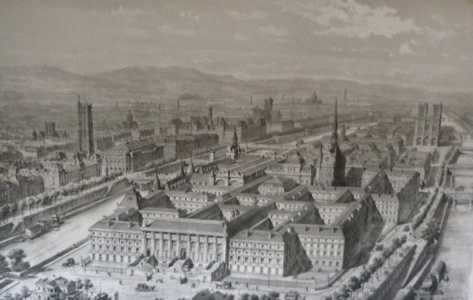
[HUYOT, JN ; DUC, J-L ; DOMMEY, E-T ; DAUMET, H.]
Documents relatifs aux travaux du Palais de Justice de Paris et à la reconstruction de la Préfecture de Police. Planches et légendes. Impression votée par le Conseil municipal, dans sa séance du 1er février 1856; Par le Conseil général, dans sa séance du 5 octobre 1857.
Paris, Typographie Charles de Mourgues Frères, successeurs de Vinchon, Imprimeurs de la Préfecture de la Seine, 1858. In-Plano - 49 x 67 cm. Broché sous couverture (restaurée) ocre, dos en toile verte, impression en noir sur le premier plat. 2 p, 34 pl. Atlas comprenant 34 planches, dont certaines dépliantes et en couleurs : 4 plans historiques (Palais de Justice vers 1500, en 1754 d'après Delagrive, en 1772 d'après Jaillot et en 1790 d'après Verniquet), 4 planches pour l'état du Palais en 1838 et 27 planches correspondant aux divers projets de reconstruction et d'agrandissement de la Restauration au Second Empire. Rare exemplaire, répertorié seulement à la BnF et à la British Library.
Bookseller reference : 2167
|
|
|
[Hydrographic Office].
[UK Admiralty Charts: The Arabian Gulf]. Persian Gulf (2858). Approaches to Abu Zabi (3705). London, published at the Admiralty, 1970-1971.
2 nautical charts. Standard issue, 70 x 103 cm approx. with a single fold. Two fine British Admiralty Hydrographic Charts for the Gulf region, covering the entire north-eastern coastline of the Arabian Peninsula. The set comprises the comprehensive map of the entire Arabian Gulf (2858), covering the area from Basra to Ras al-Hadd, as well as the map of Trucial Oman (3705) encompassing plans of Umm Al Qaywayn, Dubai and Abu Dhabi. - First issued in 1955 and 1965 respectively, the present charts are enhanced editions from the early 1970s. The practice was to print an initial edition based on a major hydrographic survey, and then to overprint them with subsequent data as it became available. - Small creases. Very well preserved.
|
|
|
[IGN/Didier & Richard]
CARTE IGN/Didier & Richard : JURA SUD, des ROUSSES à BELLEY
Une carte géographique "Itinéraires Pédestres, Equestres, à Ski de fond" au 1:50.000e, éditée en 1986, bon état
Bookseller reference : LFA-126744322
|
|
|
[IGN]
CARTE IGN : ETATS-UNIS OUEST
Une carte géographique "Découverte du Monde" au 1:2.000.000e, éditée en 2017, bon état
Bookseller reference : LFA-126744321
|
|
|
[IGN]
CARTE IGN : ILE d'OLERON à VELO et à PIED
Une carte géographique "Carte de Loisrs de Plein Air" au 1:40.000e, éditée en 2005, bon état
Bookseller reference : LFA-126744323
|
|
|
[IGN]
CARTE IGN Feuille XXIX-29 : BEAUJEU
Une carte au 1:50.000e, éditée en 1973, bon état
Bookseller reference : LFA-126740300
|
|
|
[IGN]
CARTE IGN n° 176 : AJACCIO, BONIFACIO
Une carte topographique série "Top 100 - Tourisme et Découverte" au 1:100.000e, éditée en 2010, bon état
Bookseller reference : LFA-126745997
|
|
|
[IGN]
CARTE IGN n° 1824 : SAINTE-MAURE-de-TOURAINE
Une carte topographique série orange au 1:50.000e, éditée en 1980, bon état
Bookseller reference : LFA-126744319
|
|
|
[IGN]
CARTE IGN n° 1921 OUEST : VILLEDÔMER, AUTHON
Une carte topographique série bleue au 1:25.000e, éditée en 2005, bon état
Bookseller reference : LFA-126744311
|
|
|
[IGN]
CARTE IGN n° 1943 : GIMONT
Une carte topographique série orange au 1:50.000e, éditée en 1981, bon état
Bookseller reference : LFA-126744318
|
|
|
[IGN]
CARTE IGN n° 2048 : AULUS-les-BAINS
Une carte topographique série orange au 1:50.000e, éditée en 1987, bon état
Bookseller reference : LFA-126744314
|
|
|
[IGN]
CARTE IGN n° 2142 : VILLEMUR-sur-TARN
Une carte topographique série orange au 1:50.000e, éditée en 1982, bon état
Bookseller reference : LFA-126744317
|
|
|
[IGN]
CARTE IGN n° 2144 : VILLEFRANCHE-de-LAURAGAIS
Une carte topographique série orange au 1:50.000e, éditée en 1982, bon état
Bookseller reference : LFA-126744316
|
|
|
[IGN]
CARTE IGN n° 2145 : SAVERDUN
Une carte topographique série orange au 1:50.000e, éditée en 1983, bon état
Bookseller reference : LFA-126744315
|
|
|
[IGN]
CARTE IGN n° 2245 : CASTELNAUDARY
Une carte topographique série orange au 1:50.000e, éditée en 1982, bon état
Bookseller reference : LFA-126744313
|
|
|
[IGN]
CARTE IGN n° 2726 OUEST : BOURBON-LANCY
Une carte topographique série bleue au 1:25.000e, éditée en 2010, bon état
Bookseller reference : LFA-126744310
|
|
|
[IGN]
CARTE IGN n° 2829 EST : BEAUJEU
Une carte série bleue au 1:25.000e, éditée en 1984, bon état
Bookseller reference : LFA-126740298
|
|
|
[IGN]
CARTE IGN n° 2829 EST : CHARLIEU
Une carte série bleue au 1:25.000e, éditée en 1982, bon état
Bookseller reference : LFA-126740295
|
|
|
[IGN]
CARTE IGN n° 2830 EST : le BOIS d'OINGT
Une carte série bleue au 1:25.000e, éditée en 1996, bon état
Bookseller reference : LFA-126740296
|
|
|
[IGN]
CARTE IGN n° 2830 EST : le BOIS d'OINGT
Une carte série bleue au 1:25.000e, éditée en 1984, bon état
Bookseller reference : LFA-126740297
|
|
|
[IGN]
CARTE IGN n° 2830 OUEST : AMPLEPUIS
Une carte série bleue au 1:25.000e, éditée en 1984, bon état
Bookseller reference : LFA-126740299
|
|
|
[IGN]
CARTE IGN n° 2931 EST : L'ARBRESLE
Une carte série bleue au 1:25.000e, éditée en 1991, bon état
Bookseller reference : LFA-126740294
|
|
 Receive by email
 Download as PDF document
 RSS feed


