|
|
|
Comando Superiore A.O. 7.a Sezione Topocartografica
Regione MAI CEU - QUORAM. Scala approssimata 1:50.000. Rilievo speditivo aereofotogrammetrico 1° Aprile 1936. Toponimastica raCCOLTA PER INFORMAZIONI. Edizione provvisoria. Fogli 1, 2, 3, 4***.
4 fogli, rispettivamente di cm. 48,6x42,4; cm. 64x48,8; cm. 50x42,2; cm. 58,8x42,2. Carte in bianco e nero, ma il foglio 4 contiene in azzurro il lago ASCIANGHI. Nel pieno della campagna d'Etiopia, che richiese la costruzione o il miglioramento di molte strade in territori fino allora privi di cartografia. II I Corpo d'armala con nuove unità provenienti da altri settori, sostò tra Quoram e Mai Ciò. intensificò i lavori stradali, forzatamente rallentati durante la battaglia di Ascianghi conclusa il 4 aprile (cfr. regioesercito.it/campagne/etiopia).I 4 fogli, inseparabili
|
|
|
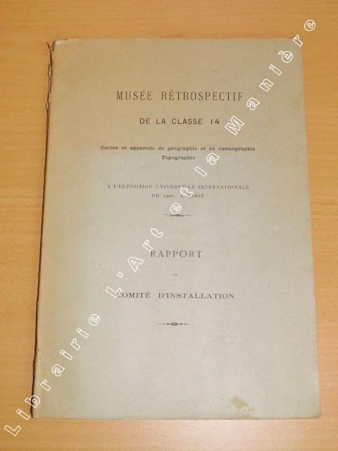
COMITE D'INSTALLATION.
Musée Rétrospectif de la classe 14. CARTES et APPAREILS DE GEOGRAPHIE ET DE COSMOGRAPHIE TOPOGRAPHIE. A l'Exposition Universelle de 1900 à Paris. Rapport du Comité d'Installation.
Saint-Cloud Imprimerie Belin 1900 In-8 - 20x28cm. Broché. 86pp.
Bookseller reference : 563
|
|
|
COMMANDANT EMILE ESPERANDIEU
Guide pratique pour la lecture et l'emploi de la carte de l'état major.
Charles Lavauzelle, 1938, 53 pages + 4 cartes, in 12 broché, état moyen, coins coupés, usures sur dos et bords des plats, rousseurs.
Bookseller reference : 12369
|
|
|
Compilation De DM. Lauhn Jensen. Cartographie De T. Franceschet Et M. Timcoe D. M.
Carte Routiere Geologique Du Manitoba 1987
Commission Geologique Du Canada. 1987 Large fold-out colour map measuring 35" x 53". Rear of map has panels with colour photographs and smaller maps. Minor wear. Near Fine. Reduced postage on this item. Book. Commission Geologique Du Canada. unknown
Bookseller reference : 20289
|
|
|
Compilded by R. V. Tooley
TOOLEY'S . Dictionary of Mapmakers.
Bross., cm 25x17,5, pp 684. - ISBN: 0845117025

|
|
|
Compiled and drawn under the direction of [LIEUTENANT COLONEL] F. J. SALMON, (Director of Land Registration and Surveys, Cyprus, 1932).
[SALMON'S MAP OF CYPRUS] Survey of Cyprus administration map. Scale of 4 miles to one inch = 1/253440.
Very Good English Revised Third Edition of this rare map of Cyprus, made by Salmon, who was the director of Cypriot land registration and surveys. "Shows grid, district boundaries, heights in feet, railways, roads (2 categories), antiquities, ancient sites.". / "Shows district boundaries, towns and cities, roads (2 categories), railroads, ancient sites and antiquities, and dry streams. Relief is shown by contours, gradient tints, and spot heights. Earlier Edition: 1952.". (OCLC). "In December 1926, in a memorandum to the Colonial Office on vacant surveying positions in the colonies, Palestine and Cyprus were mentioned at the end of a group of Mediterranean colonies; that is there was a group of Mediterranean colonies, and also Cyprus and Palestine [.] Only in 1929 was an Imperial project involving Palestine and Transjordan, brought up at the committee (Colonial Survey Committee). This was the experimental aerial survey for determining the route of the Haifa - Damascus railway, which was presented as a model for mapping from aerial photographs [.] Among the important things reported to the Colonial Survey Committee was the reconnaissance conducted by Colonial Winterbotham, the Chief of the GSGS, in the survey departments of the colonies in 1929, a trip that had been encouraged in the first Conference of Empire Survey Officers in 1928 [.] ... how much Salmon [F. J.] expected from Winterbotham's visit to Ceylon a short time before he was to take over the directorship of the small survey department of Cyprus.". (Source: The Survey of Palestine Under the British Mandate, 1920-1948). Original color map. Folded in original wrappers. Fine. Elephant folio. (58 x 89 cm). In English. Survey of Cyprus administration map. Scale of 4 miles to one inch = 1/253440. Compiled and drawn under the direction of F. J. SALMON, (Director of Land Registration and Surveys, Cyprus, 1932). Revised Third Edition. Second in 1950.
|
|
|
Compiled by R.V. Tooley
Tooley's. Dictionary of Mapmakers. Supplenent.
Ril. in tela con sovr., cm 26x18,5, pp 116 alcune ill.. - ISBN: 0845117033

|
|
|
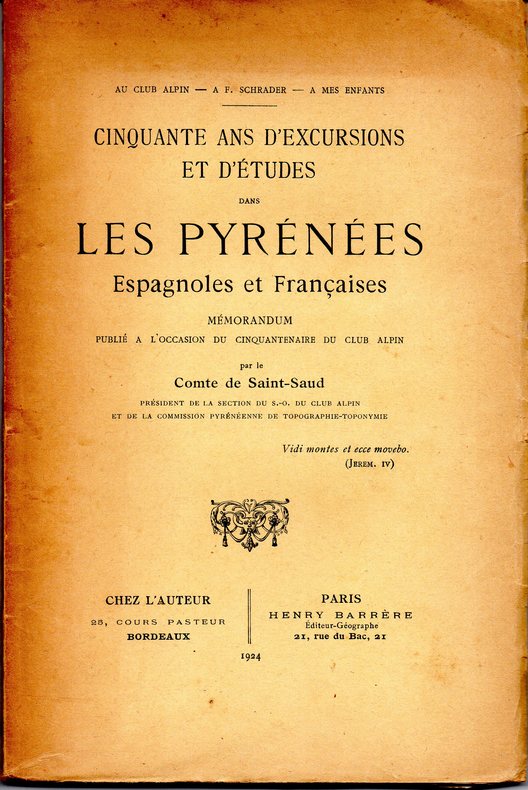
Comte de Saint Saud
Cinquante ans d'excursions et d'études dans les Pyrénées Espagnoles et Françaises
Mémorandum publié à l'occasion du cinquantenaire du Club alpin, Chez l'auteur/Henry Barrère, 1924. Avec ses 5 planches.
Bookseller reference : ZNF-541
|
|
|
COMTE MAXIME DE SARS LUCIEN BROCHE
Histoire de Braine.
Albert Delayance éditeur, La Charité sur Loire, 1933, 317 pages, en partie non coupé, in 8 broché, état d'usage, quelques usures et pliures, coins frottés et coiffes usées.
Bookseller reference : 10447
|
|
|
COMTESSE JULIETTE DE ROBERSART
Orient Syrie, journal de voyage dédié à sa famille par la Comtesse Juliette de Robersart (tomes 1 et 2).
Challamel ainé, libraire éditeur de l'Oeuvre des Pélerinages en Terre-Sainte, Commissionnaire pour la Marine, les Colonies et l'Orient, 1867, tome 1: 307 pages, tome 2: 429 pages, in 12 broché, état d'usage, insolé, papier jauni, coins, coiffes et bords des plats frottés (légers manques sur le bord des plats).
Bookseller reference : 12621
|
|
|
COMUNE DI PESARO - CASSA DI RISPARMIO DI PESARO.
La terra e le sue copie. Leonardo, Raffaello, Boscovich, la cartografia del Ducato e della Legazione di Urbino. Catalogo della mostra a cura di Enrico Gamba e Vico Montebelli tenutasi nella Sala Laurana - Palazzo Ducale - Pesaro, 7 agosto - 24 settembre 1991.
In-8° gr. carrè, pp. 95 con 14 illustrazioni e figure n.t. di cui alcune sono a colori e riproducono antiche mappe. Bross. edit. illustrata con lievi tracce del tempo e leggere abrasioni su dorso e piatti. Timbri di biblioteca all'interno.

|
|
|
COMUNE DI ROMA ..
Atlante di Roma. La forma del centro storico in scala 1:1000 nel fotopiano e nella carta numerica.
In-4° carré, leg. in tela e sop.c. edit., pp. 625(3). Con 276 tavv. a colori del fotopiano, fronteggiate dal settore corrispondente della carta numerica. In cof. telato editoriale. Abrasioni agli spigoli del cofanetto, per il resto ottimo stato di conservazione.
|
|
|
Comune di Siviglia/Commissione urbanistica:
Atlante di Siviglia. La forma del centro storico in
<br/> TITOLO: Atlante di Siviglia. La forma del centro storico in scala 1:1000 nel fotopiano e nella carta.<br/> AUTORE: Comune di Siviglia/Commissione urbanistica:<br/> CURATORE: Fotopiano realizzato dalla Compagnia Generale Ripreseaeree. Testi di José Nunez Castain, Rosa Bonetta, Licinio Ferretti.<br/> EDITORE: Marsilio Ed.<br/> DATA ED.: 1992,<br/> EAN: 9788831755184
|
|
|
Conan Doyle Adrian
Gli artigli del paradiso [Oceano Indiano]
22 foto in bianco e nero

|
|
|
CONFEDERAZIONE GUATIMALESE o Stati-Uniti dell'America Centrale.
Carta incisa in rame e acquarellata a mano.
Carta di cm 34 x 23 alla cornice, più i margini. Ampio testo descrittivo nella metà inf. della tavola. Tratta da 'Atlante storico, geografico, genealogico, cronologico e letterario di M. A. Le Sage in ogni sua parte corretto, ampliato e proseguito sino all'anno corrente. Prima Veneta Edizione'.
|
|
|
CONFLIT HISPANO-AMÉRICAIN.-
Carte du Théâtre de la Guerre Dressée Spécialement pour les Lecteurs de la Dépêche.-
[Toulouse]. La Dépêche. (1898). Grande carte de 780 x 560 mm toutes marges comprises, gravée par Charaire, partie centrale, la carte proprement dite, en couleurs, entourée de divers sujets en noir avec texte en bas de feuille. Intéressante pièce, supplément du journal La Dépêche. La carte décrit les flottes navales de l'Espagne et celle de l'Amérique dans l'Océan Atlantique et représente les 10 longues semaines de cette guerre déclarée à propos de l'indépendance de Cuba. Elle est entourée de vignettes montrant les uniformes de chacune des armées ainsi que des vues de La Havane, Santiago de Cuba, Matanzas et le Fort des Boucaniers. Traces légères de pliage en 8 mais très bon état de ce fragile document malgré qq. menus défauts. Rare. (2). Photo sur demande.
Bookseller reference : ORD-17445

|
|
|
Congresso:
Atti del VIII Congresso Geografico Italiano. Vol. I: Ordinamenti rendiconti
3 voll. <br/> TITOLO: Atti del VIII Congresso Geografico Italiano. Vol. I: Ordinamenti rendiconti e conferenze, con 36 belle ill. fotografiche f.t. e 4 carte piu' volte ripieg. Vol. II: Comunicazioni, con molte ill. intercalate n.t. e 17 carte f.t. in b/n e col. piu' volte ripieg. (tra cui bella veduta prospettica di una carta di Firenze del 1470 detta "Della Catena"); Vol.III: Escursione e Mostre, catalo
|
|
|
CONSIDERANT (Victor)
Au Texas.
1854 In-8 (209 x 134 mm), demi-maroquin rouge à grain long, dos orné de filets à froid, auteur et titre dorés (rel. moderne signée Laurenchet), (4), 194 p., 4 p. de catalogue éditeur, 2 grandes cartes dépliantes. Paris, Librairie Phalanstérienne, 1854.
Bookseller reference : 38446

|
|
|
CONSIDERANT (Victor)
Au Texas.
In-8 (209 x 134 mm), demi-maroquin rouge à grain long, dos orné de filets à froid, auteur et titre dorés (rel. moderne signée Laurenchet), (4), 194 p., 4 p. de catalogue éditeur, 2 grandes cartes dépliantes. Rare édition originale distribuée hors commerce "aux amis" et sympathisants fouriéristes, comme précisé par l'auteur dans son avertissement. Véritable programme matériel pour la colonisation phalanstérienne du Texas, l'ouvrage est illustré de deux grandes cartes repliées hors texte avec contours coloriés imprimées par Lemercier: une des États-Unis gravée par les Frères Avril, l'autre du Texas par F. Delamare, d'après J.-H. Colton. "Considérant développe son projet. Il relate son voyage et fait des descriptions du Texas qu’il présente comme la Terre promise et le lieu idéal pour l’expérimentation sociale (…). Il propose la fondation d’une agence de colonisation, suivie de la création d’un grand champ d’asile ouvert à toutes sortes d’expériences sociales, dont celles fouriéristes (…). Dès sa parution, "Au Texas" rencontra un succès immédiat qui dépassa toutes les prévisions (…). C’est poussé par ce succès et par l’impatience manifestée par les aspirants colons que François Cantagrel partit pour le Nouveau Monde le 3 oct. 1854 avec comme mission de rechercher l’emplacement de la future colonie" ("Les premiers socialismes", Expo. virtuelle, 2008, U. de Poitiers, en ligne). Né à Salins (Jura), polytechnicien, Victor Considérant (1808-1893) renonça à la carrière militaire pour se consacrer à la diffusion des idéaux fouriéristes, jusqu'à reprendre la tête du mouvement à la mort de Fourier en 1837. La "Colonie de Réunion" fondée près de Dallas (Texas) tourna rapidement au fiasco. Après plusieurs années à San Antonio, Considérant rentra à Paris en 1869 à la faveur d'une amnistie, adhéra un temps à la Première Internationale, puis se retira de la vie politique. Il est l'un des pionniers du socialisme en France. (Del Bo, p. 70. Dommanget, 'V. Considérant', n°46. Owes, n°697. Jenkins, 'Basic Texas Books', 33. Sabin, 1592). Page de titre montée sur onglet. Rousseurs et piqûres éparses. Les cartes sont parfaitement conservées. Bon exemplaire, bien relié.
|
|
|
Consiglio Nazionale delle Ricerche.
CHE COSA SONO I TERREMOTI E COME POSSIAMO DIFENDERCI. Dispense e testo delle parti audiovisive.
(Codice GL/0332) In 8º (24x17 cm) 223 pp. Con 16 tavole a colori fuori testo e numerose figure nel testo. Brossura editoriale. Lievemente usato, buon volume. ~~~ SPEDIZIONE IN ITALIA SEMPRE TRACCIATA

|
|
|
Consociazione Turistica Italiana
Il Cadore, la Carnia, l'Alto Isonzo. Guida storico-turistica
cartine tavole in nero fuori testo

|
|
|
Consociazione Turistica Italiana
Il medio e il basso Isonzo. Guida storico-turistica
96 tavole in bianco e nero fuori testo

|
|
|
Consorzio Universitario Piceno - Ascoli Piceno
Piceno. Periodico del Centro di studi storici ed etnografici del Piceno. Anno VI n. 1 - Giugno 1982.
In 8? (cm 24), Brossura, pagg.54 con alcune ill. b.n. n.t., segni del tempo alla cop., buon es. Dal sommario: "Le parler rural d'Ascoli Piceno" di A. Piccinin; "La cartografia storica territoriale della regione marchigiana (1561-1713)" di F. Bonasera; "L'idea di letteratura in Adolfo e Lauro De Bosis" di A. Luzi; "Flaminio d'Ascoli pittore indemoniato" di R. Paciaroni; "Nino Anastasi" di A. Massimi. Il volume ? stato "realizzato fotograficamente con elaboratore elettronico".

|
|
|
Consoziazione turistica italiana.
Carta automobilistica alla scala 200.000. Disponiamo di tutta la parte superiore superiore dell'Italia in 11 carte fin sopra Firenze con l'esclusione della carta di ravenna e Rimini.
Carta piegata a soffietto di cm. 107 X 24 a colori. con piatti in cartoncino edit. Con leggenda all'interno dei piatto ant. e pubblicità su quello post. Tutti.

|
|
|
CONTI Paolo -
La falda austroalpina dell'Ortles e l'evoluzione tettonica delle Dolomiti dell'Engandina (Svizzera - Italia) . The Austroalpine Ortler nappe and the tectonic evolution of the Engadine (Switzerland - Italy) . Memorie descrittive della carta geologica d'Italia. Volume LIII.
Roma, Istituto Poligrafico e Zecca dello Stato, 1997, 8vo (cm. 29,5 x 21,5) brossura con copertina illustrata a colori, pp. 102 con 69 illustrazioni in nero e a colori nel testo e 17 carte più volte ripiegate, raccolte in brossura inserita in una tasca in fine al volume.

|
|
|
Conti Sergio (a cura)
RIFLESSI ITALIANI. L'dentità di un Paese nella rappresentazione del suo territorio.
(Codice IT/0434) In 4° (29x22,5 cm) 255 pp. Illustrazioni a colori e in nero. Cartone editoriale, titolo oro, sovraccoperta. Come nuovo. ~~~ SPEDIZIONE IN ITALIA SEMPRE TRACCIATA

|
|
|
Continenza B. - Di Siena G. - Ferracin A. - Gagliasso E.
I cartografi dell'impero. Specie, razza, istinto: evoluzione e ideologia.
pp. 191, cm 18x11, bross., I Nuovi Testi 207
|
|
|
Cook James
A PLAN OF THE RIVER ST. LAURENCE
London: Christies 1967. 5pp. Photographic folding plan of the manuscript bound in. The sale catalogue of the manuscript of Cook's plan of the River St. Laurence form Green Island to Cape Car Rouge from July 5th 1967. Paper Wrappers. Fine. 8vo - over 7�" - 9�" tall. Christies Hardcover
Bookseller reference : J727
|
|
|
Cook, James; Anderson, George William, editor
A COLLECTION OF VOYAGES ROUND THE WORLD PERFORMED BY ROYAL AUTHORITY : CONTAINING A COMPLETE HISTORICAL ACCOUNT OF CAPTAIN COOK'S FIRST, SECOND, THIRD AND LAST VOYAGES, UNDERTAKEN FOR MAKING NEW DISCOVERIES, &C. ... : TO WHICH ARE ADDED GENUINE NARRATIVES OF OTHER VOYAGES OF DISCOVERY ROUND THE WORLD, &C. VIZ. THOSE OF LORD BYRON, CAPT. WALLIS, CAPT. CARTERET, LORD MULGRAVE, LORD ANSON, MR. PARKINSON, CAPT. LUTWIDGE, MESS. IVES, MIDDLETON, SMITH, &C. & C ... VOL IV ONLY [OF 6]
1st edition thus. Later limp cloth, 8vo, pages 1185- 1546 [ie. 361 pages this volume, as issued]. Many illustrations, portfolios, maps (some folded) ; 21 cm. Includes 6 fold out maps: Map of Kerguelens Land called by C. Cook Island of Desolation; Chart of Van Diemens Land; Plan of Adventure Bay on Van Diemens Island; Wanooaette Island, Wateeoo I., Mangeea Isalnd, Toobuai Island; Sketch of Tongataboo Harbour; Chart of the Friendly Island. 27 full page illustrations. From title page: This edition is compiled from the authentic journals of several Principal Officers and other Gentlemen of the most distinguished naval and philosophical abilities, who failed in the various ships. These works which detail the experiences of the voyages of Captain James Cook from 1772 until his untimely death in the Hawaiian Islands in early 1779. These volumes were written not by Cook, but by those who accompanied him. OCLC: 2547038. SUBJECT(S): Voyages around the world -- Early works to 1800. Originally issued in eighty unbound parts. Bit of foxing Very Good Condition. (AMR-67-2)
|
|
|
Cooke George Alexander
Modern and authentic system of universal Geography
London: C. Cooke 1802. : containing an accurate and entertaining description of Europe Asia Africa and America being a complete and universal history and description of the whole world as divided into Empires. 2 volumes. 'Upwards of 100 engravings'. All plates and maps present as per the binders list. 24 MAPS SOME FOLDING ALL HAND-COLOURED. The two North American plates have small fold splits with a trifle loss otherwise all plates are fine and lovely dark impressions with fine hand-colouring to the maps. Undated but presumed 1802 first edition. Hand-coloured maps and copper-plate engraving throughout. Rubbed and worn full calf original binding with black calf labels gilt. Armorial bookplates in each volumes of T. Grimshaw with marbled end-papers. The fine world map was engraved by A. Arrowsmith and engraved by J. Lodge. The anon. large folding Pacific Ocean is complete but torn to the lower centre fold. The plate list calls for 8 extra plates given in the 'Fine' edition. These are all present and are beautiful strong dark impressions. PLEASE EMAIL FOR PHOTOS. Extra Illustrated Fine Edition. Hardback. V.g. 4to. Atlas. C. Cooke Hardcover
Bookseller reference : Le534
|
|
|
Corbellini Giancarlo.
UNA SCIENZA PER L'UOMO. Scienze della terra e geografia umana.
(Codice CE/0152) In 8º (26,5 cm) 384 pp. Varie centinaia di illustrazioni a colori. Brossura editoriale, STATO DI NUOVO. ~~~ SPEDIZIONE IN ITALIA SEMPRE TRACCIATA

|
|
|
Corbellini P. (capo cartografo)
CONSOCIAZIONE TURISTICA ITALIANA. CARTA AUTOMOBILISTICA AL 200000. FOGLIO 4
Cartina automobilistica zone Aosta, Varese, Como, Novara. Buone condizioni.Luogo di pubblicazione Milano Editore Ufficio Cartografico della C.T.I.Anno pubblicazione Anni '40Materia/Argomento Cartografia

|
|
|
Corbellini P. (capo cartografo)
CONSOCIAZIONE TURISTICA ITALIANA. CARTA AUTOMOBILISTICA AL 200000. FOGLIO 5
Cartina automobilistica zone Sondrio, Trento, Bergamo, Brescia, Verona, Vicenza. Buone condizioni.Luogo di pubblicazione Milano Editore Ufficio Cartografico della C.T.I.Anno pubblicazione Anni '40Materia/Argomento Cartografia

|
|
|
Corbellini P. (capo cartografo)
CONSOCIAZIONE TURISTICA ITALIANA. CARTA AUTOMOBILISTICA AL 200000. FOGLIO 7
Cartina automobilistica zone Vercelli, Pavia, Torino. Buone condizioni.Luogo di pubblicazione Milano Editore Ufficio Cartografico della C.T.I.Anno pubblicazione Anni '40Materia/Argomento Cartografia

|
|
|
Corbellini P. (capo cartografo)
CONSOCIAZIONE TURISTICA ITALIANA. CARTA AUTOMOBILISTICA AL 200000. FOGLIO 8
Cartina automobilistica zone Cremona, Padova, Mantova, Parma, Modena. Buone condizioni.Luogo di pubblicazione Milano Editore Ufficio Cartografico della C.T.I.Anno pubblicazione Anni '40Materia/Argomento Cartografia

|
|
|
Corbellini P. (capo cartografo)
CONSOCIAZIONE TURISTICA ITALIANA. CARTA AUTOMOBILISTICA AL 200000. FOGLIO 10
Cartina automobilistica zone Genova, Cuneo, Imperia. Buone condizioni.Luogo di pubblicazione Milano Editore Ufficio Cartografico della C.T.I.Anno pubblicazione Anni '40Materia/Argomento Cartografia

|
|
|
Corbellini P. (cartografo)
Carta del Levante - Scala 1:3.000.000
Carta più volte ripiegata; supplemento alla Rivista mensile "Le vie d'Italia" (33f).
|
|
|
Cori - Ostermann.
GEOGRAFIA GENERALE E GEOLOGIA per le scuola medie superiori.
(Codice OS/0282) In 8° 381 pp., 413 illustrazioni. Tela editoriale, titolo oro, orrimo stato, ~~~ SPEDIZIONE IN ITALIA SEMPRE TRACCIATA

|
|
|
Cori,Berardo.
L'Europa Orientale e l'Unione Sovietica.
2 voll. <br/> TITOLO: L'Europa Orientale e l'Unione Sovietica. <br/> AUTORE: Cori,Berardo.<br/> EDITORE: UTET<br/> DATA ED.: 1989,<br/> COLLANA: Coll.Il Mondo Attuale.<br/>
|
|
|
Corna Pellegrini Giacomo
Per una geografia delle città pioniere. Hassi Messaoud centro petrolifero del Sahara algerino
41 illustrazioni in nero fuori testo

|
|
|
Corna Pellegrini,Giacomo.
L'Asia Meridionale e Orientale.
2 voll. <br/> TITOLO: L'Asia Meridionale e Orientale. <br/> AUTORE: Corna Pellegrini,Giacomo.<br/> EDITORE: UTET<br/> DATA ED.: 1982,<br/> COLLANA: Coll.Il Mondo Attuale.<br/>
|
|
|
Cornelius a Wytefliet
THEATRUM ORBIS TERRARUM DESCRIPTIONIS PTOLEMAICAE AUGMENTUM
Amsterdam: Meridian Publishing Company 1964. 192pp including 19 double page maps in black and white and an introduction by R.A. Skelton. A facsimile edition of the first atlas entirely devoted separately to the Americas. Originally published in 1597. A series of atlases in Facsimile. First series volume V. Small closed tear to the lower edge of the d.j. otherwise a lovely clean and unused copy. facimile reprint. hardback. Fine/Fine. small folio. Meridian Publishing Company Hardcover
Bookseller reference : P266
|
|
|
Cornellini P. (Capo Cartografo)
CARTA D'ITALIA ALLA SCALA DI 1:500000 FOGLIO 1 - 8
8 cartine geografiche ripiegate. Buone condizioni.Luogo di pubblicazione Milano Editore Touring Club ItalianoAnno pubblicazione s.d.Materia/Argomento Cartografia

|
|
|
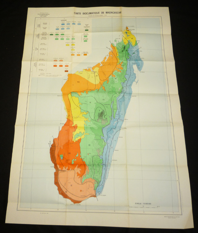
Cornet A.
Notice explicative, n°55 : Essai de cartographie bioclimatique à Madagascar
Orstom Plaquette 1974 In-8 (15.5 x 23 cm), plaquette, 28 pages, avec deux grandes cartes volante en couleurs ; pliure et coins cornés au premier plat, une des cartes fragilisée, réparée au ruban adhésif sur l'envers, par ailleurs assez bon état général. Livraison a domicile (La Poste) ou en Mondial Relay sur simple demande.
Bookseller reference : ve80
|
|
|
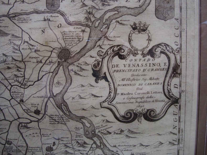
CORONELLI
Contado de Venassino, e prencipato d'Oranges ..
Très belle carte du Comtat et de la Principauté d'Orange, datée 1690. Cadre et passe-partout modernes. Très bon 1690 63 x 79 cm avec le cadre.
Bookseller reference : 8235
|
|
|
Coronelli Vincenzo
Territorio di Naiasel e Gran sin'a Comora
Incisione su rame in due fogli uniti di mm 602 x 450 alla battuta su carta vergata di filo. Margine superiore breve; buon esemplare senza difetti. Dedica nella parte inferiore al "Sig. Gio: Gasparo Cobenzl, Cameriere delle Chiavi d'Oro di S. Maestà Cesarea, et Accademico degli Argonauti". Proviene dall'opere stampata a Venezia dal titolo "Corso Geographico Universale". Il foglio rappresenta la descrizione topografica delle battaglia tra gli Austro-Polacchi e l'Armata Turca combattute a Gran ed a Neuhaeusel in Ungheria nel 1685, due anni dopo l'assedio di Vienna.

|
|
|
Coronelli Vincenzo Maria
Cefalonia
Doppia incisione calcografica di mm 162 x 130 e 165 x 125 su foglio di mm 497 x 365. Proveniente dal "Isolario, descrittione geografico-historica, sacro-profana, antico-moderna, politica, naturale, e poetica. Mari, golfi, seni, piagge, porti, barche, pesche, promontorj, monti, boschi, fiumi ... ed ogni piu esatta notitia di tutte l'isole coll'osservationi degli scogli sirti, scagni, e secche del globo terracqueo. Aggiuntivi anche i ritratti de' dominatori di esse. Ornato di trecento-dieci tavole geografiche, topografiche, corografiche, iconografiche, scenografiche ... a' maggiore dilucidatione, ed uso della navigatione, et in supplimento dei 14 volumi del Bleau. Tomo II. dell'Atlante veneto. Opera, e studio del p. maestro Vincenzo Coronelli ..". (P. 49). Tutto il resto della pagina edil retro è occupato dalla storia a partire dalle origini, dell'isola. E. Armao, Vincenzo Coronelli p.116-124; E.A. Cicogna, Saggio di bibliografia veneziana p.617-618 n.4588; NUC pre-1956 v.123 p.316; Un intellettuale europeo e il suo universo ... a cura di M.G. Tavoni p.219

|
|
|
Coronelli Vincenzo Maria
Città di Murano
Incisione con veduta di mm 253 x 110 su foglio di mm 354 x 483 proveniente dal "Isolario, descrittione geografico-historica, sacro-profana, antico-moderna, politica, naturale, e poetica. Mari, golfi, seni, piagge, porti, barche, pesche, promontorj, monti, boschi, fiumi ... ed ogni piu esatta notitia di tutte l'isole coll'osservationi degli scogli sirti, scagni, e secche del globo terracqueo. Aggiuntivi anche i ritratti de' dominatori di esse. Ornato di trecento-dieci tavole geografiche, topografiche, corografiche, iconografiche, scenografiche ... a' maggiore dilucidatione, ed uso della navigatione, et in supplimento dei 14 volumi del Bleau. Tomo II. dell'Atlante veneto. Opera, e studio del p. maestro Vincenzo Coronelli ..". (P. 38). E. Armao, Vincenzo Coronelli p.116-124; E.A. Cicogna, Saggio di bibliografia veneziana p.617-618 n.4588; NUC pre-1956 v.123 p.316; Un intellettuale europeo e il suo universo ... a cura di M.G. Tavoni p.219

|
|
|
Coronelli Vincenzo Maria
Contado di Zelanda Dedicato All'Illustrissimo, e Reverendissimo Signore, Monsignore Vincenzo Cavalli.
Incisione su rame all'acquaforte e bulino. Foglio unico di due incollati insieme di mm 615 x 467. Carta di filo senza tinte, porosa e spessa. Filigrana non rilevata. Ottimo foglio a grandi margini, in carta candida e forte. Titolo in alto a destra entro ricco cartiglio. Toponimi e descrizioni geografiche nella pianta inolandese. Proveniente da: "Corso Geografico Universale", Venezia 1692. Vincenzo Maria Coronelli (August 16, 1650 - December 9, 1718) was a Franciscan monk, an Italian cosmographer, publisher and encyclopedist known in particular for his globes. Born in Venice, Coronelli became a Minorite Friar and doctor of Theology at the Collegium San Bonaventura in Rome. In 1678 Coronelli created two globes for the Duke of Parma. These globes had a diameter of c. 175cm and were finely crafted. This drew the attention of the French ambassador, César d'Estrées, who subsequently invited Coronelli to Paris. Coronelli moved to the French capital in 1681, where he lived for two years. Coronelli was commissioned by the cardinal d'Estrées to produce two globes, one of the earth, the other of the heavens, for king Louis XIV. These globes measuring 384cm in diameter are presently relocated to their new place, Bibliothèque nationale François Mitterrand in Paris. Due to his renown he worked in various European countries in the following years, permanently returning to Venice in 1705. In Venice he started his own cosmographical project and published the volumes of Atlante Veneto. In his home city he founded the very first geographical society, the Accademia Cosmografica degli Argonauti. He also held the position of Cosmographer of the Republic of Venice. Later six volumes of the Biblioteca Universale Sacro-Profana were published by Coronelli. This was the first encyclopedia to be ordered alphabetically. Coronelli died at the age of 68 in Vienna, having created hundreds of maps in his lifetime. Original globes by Coronelli are today located in several collections. Pairs of his most famous large (c. 110 cm diameter) globes are e.g. in the Biblioteca Marciana in Venice, in the National Library of Austria and in the Globe Museum in Vienna, in the library of Stift Melk, as well as in Trier, Prague, Paris, London, Washington D.C.. Having been restored and completed, another 1688 terrestrial globe is displayed at the Southwest Collection/Special Collections Library of Texas Tech University in Lubbock, Texas. The International Coronelli Society for the Study of Globes, founded 1952 in Vienna, is named in Coronelli's honour. Ermanno Armao (1944) p. 108 e seguenti.

|
|
|
Coronelli Vincenzo Maria
Dell'isola di S. Clemente
Incisione calcografica di mm 187 x 122 su foglio di mm 460 x 360. Nel carteggio :"Isola di S. Clemente". Proveniente dal "Isolario, descrittione geografico-historica, sacro-profana, antico-moderna, politica, naturale, e poetica. Mari, golfi, seni, piagge, porti, barche, pesche, promontorj, monti, boschi, fiumi ... ed ogni piu esatta notitia di tutte l'isole coll'osservationi degli scogli sirti, scagni, e secche del globo terracqueo. Aggiuntivi anche i ritratti de' dominatori di esse. Ornato di trecento-dieci tavole geografiche, topografiche, corografiche, iconografiche, scenografiche ... a' maggiore dilucidatione, ed uso della navigatione, et in supplimento dei 14 volumi del Bleau. Tomo II. dell'Atlante veneto. Opera, e studio del p. maestro Vincenzo Coronelli ..". (P. 49). Tutto il resto della pagina edil retro è occupato dalla storia a partire dalle origini, dell'isola. E. Armao, Vincenzo Coronelli p.116-124; E.A. Cicogna, Saggio di bibliografia veneziana p.617-618 n.4588; NUC pre-1956 v.123 p.316; Un intellettuale europeo e il suo universo ... a cura di M.G. Tavoni p.219

|
|
|
 Receive by email
 Download as PDF document
 RSS feed


