|
COLLECTIF
"CARTE ""LILLE ET SES ENVIRON"" n°1"
A. TARIDE EDITEUR. NON DATE. In-Plano. En feuillets. Bon état, Couv. convenable, Dos satisfaisant, Intérieur frais. Carte pliée mesurant 65cmx90cm, à l'échelle 1/250.000. Carte en couleur. Carte consolidé avec du scotch. . Sous Emboitage. . Classification Dewey : 912-Atlas, cartes et plans
Bookseller reference : R240002071
|
|
|
COLLECTIF
"CARTE ""LILLE S.E"" révisée en 1898 - type 1889"
. NON DATE. In-Plano. En feuillets. Bon état, Couv. convenable, Dos satisfaisant, Intérieur frais. Carte pliée mesurant 35cmx54cm, échelle non mentionnée. Carte en noir et blanc.. . . . Classification Dewey : 912-Atlas, cartes et plans
Bookseller reference : R240002054
|
|
|
COLLECTIF
"CARTE ""LILLE S.O"" révisée en 1898 - Type 1889"
. NON DATE. In-Plano. En feuillets. Bon état, Couv. convenable, Dos satisfaisant, Intérieur frais. Carte pliée mesurant 35cmx54cm à l'échelle 1/80.000. Carte en noir et blanc.. . . . Classification Dewey : 912-Atlas, cartes et plans
Bookseller reference : R240002046
|
|
|
COLLECTIF
"CARTE ""LILLE"" révisée en 1898 - Type 1889"
. NON DATE. In-Plano. En feuillets. Bon état, Couv. convenable, Dos satisfaisant, Intérieur frais. Carte pliée mesurant 35cmx54cm à l'échelle 1/100.000. Carte en noir et blanc.. . . . Classification Dewey : 912-Atlas, cartes et plans
Bookseller reference : R240002051
|
|
|
COLLECTIF
"CARTE ""LURE"" n°100 - révisée en 1911"
. NON DATE. In-Plano. En feuillets. Bon état, Couv. convenable, Dos satisfaisant, Intérieur frais. Carte pliée mesurant 60cmx85cm, échelle non mentionné. Carte en noir et blanc. Déchirure en marge et aux pliures altérant la lecture.. . . . Classification Dewey : 912-Atlas, cartes et plans
Bookseller reference : R240002061
|
|
|
COLLECTIF
"CARTE ""MAUBEUGE - BRUXELLE"" n°5 - type 1912"
SERVICE GEOGRAPHIQUE DE L'ARMEE. NON DATE. In-Plano. En feuillets. Bon état, Couv. convenable, Dos satisfaisant, Intérieur frais. Carte pliée mesurant 52cmx70.5cm, à l'échelle 1/200.000. Carte en couleur.. . . . Classification Dewey : 912-Atlas, cartes et plans
Bookseller reference : R240002069
|
|
|
COLLECTIF
"CARTE ""MAUBEUGE BRUXELLE"" n°5 type 1912"
SERVICE GEOGRAPHIQUE DE L'ARMEE. 1912. In-Plano. En feuillets. Bon état, Couv. convenable, Dos satisfaisant, Intérieur acceptable. Carte pliée mesurant 54cmx68cm à l'échelle 1/200.000. Carte en couleur. Quelques rousseurs sur le dos de la carte.. . . . Classification Dewey : 912-Atlas, cartes et plans
Bookseller reference : R240002019
|
|
|
COLLECTIF
"CARTE ""MONTDIDIER"" révisée en 1902 - Type 1889"
. NON DATE. In-Plano. En feuillets. Etat d'usage, Couv. légèrement passée, Dos satisfaisant, Quelques rousseurs. Carte pliée mesurant 35cmx54cm à l'échelle 1/100.000. Carte en noir et blanc.. . . . Classification Dewey : 912-Atlas, cartes et plans
Bookseller reference : R240002050
|
|
|
COLLECTIF
"Carte ""Official Map Pennsylvania"""
DEPARTMENT OF HIGHWAYS. Non daté. In-12. En feuillets. Bon état, Couv. légèrement passée, Dos satisfaisant, Intérieur frais. Carte dépliante en couleurs de 59 x 92 cm. Légendes en anglais. Quelques annotations à l'encre, en m. . . . Classification Dewey : 912-Atlas, cartes et plans
Bookseller reference : RO80150375
|
|
|
COLLECTIF
"CARTE ""QUETTA"" ET ""ZIARAT"" EN PAKISTAN - CARTE DE DIMENSION 45 X 66 CM ENVIRON."
NON PRECISE. NON DATE. In-Plano. En feuillets. Bon état, Couv. convenable, Dos satisfaisant, Intérieur frais. Carte en couleurs (recto-verso) de DIMENSION : 45x66 cm environ.. . . . Classification Dewey : 912-Atlas, cartes et plans
Bookseller reference : ROD0113264
|
|
|
COLLECTIF
"CARTE ""REIMS ET SES ENVIRON"" n°3"
A. TARIDE EDITEUR. NON DATE. In-Plano. En feuillets. Etat d'usage, Couv. légèrement passée, Dos satisfaisant, Quelques rousseurs. Carte pliée mesurant 70cmx89cm, à l'échelle 1/250.000. Carte en couleur. Carte consolidé avec du scotch. . Sous Emboitage. . Classification Dewey : 912-Atlas, cartes et plans
Bookseller reference : R240002070
|
|
|
COLLECTIF
"CARTE ""REIMS"" n°34 - révisée en 1913"
. NON DATE. In-Plano. En feuillets. Bon état, Couv. convenable, Dos satisfaisant, Quelques rousseurs. Carte pliée mesurant 59cmx85cm, échelle non mentionnée. Carte en noir et blanc.. . . . Classification Dewey : 912-Atlas, cartes et plans
Bookseller reference : R240002055
|
|
|
COLLECTIF
"CARTE ""RETHEL S.O"" n°23 - révisée en 1912"
. NON DATE. In-Plano. En feuillets. Etat d'usage, Couv. convenable, Dos satisfaisant, Déchirures. Carte pliée mesurant 59cmx85cm, à l'échelle 1/50.000. Carte en noir et blanc et trait rouge. Quelques déchirures au pliures altérant un peu la lecture. Carte froissée.. . . . Classification Dewey : 912-Atlas, cartes et plans
Bookseller reference : R240002056
|
|
|
COLLECTIF
"CARTE ""RETHEL"""
. NON DATE. In-Plano. En feuillets. Bon état, Couv. convenable, Dos satisfaisant, Intérieur frais. Carte pliée mesurant 54cmx69cm, échelle non mentionnée. Carte en noir et blanc, et trait rouge.. . . . Classification Dewey : 912-Atlas, cartes et plans
Bookseller reference : R240002067
|
|
|
COLLECTIF
"CARTE ""ST OMER"" révisée en 1898 - Type 1889"
. NON DATE. In-Plano. En feuillets. Bon état, Couv. convenable, Dos satisfaisant, Intérieur frais. Carte pliée mesurant 35cmx54cm à l'échelle 1/80.000. Carte en noir et blanc. Légère déchirures aux pliures.. . . . Classification Dewey : 912-Atlas, cartes et plans
Bookseller reference : R240002047
|
|
|
COLLECTIF
"CARTE ""TERRITOIRE DE BELFORT ET SA FRONTIERE ALLEMANDE"""
. NON DATE. In-Plano. En feuillets. Bon état, Couv. convenable, Dos satisfaisant, Intérieur frais. Carte pliée mesurant 51cmx65cm, à l'échelle 1/80.000. Carte en couleur. Dos consolidé avec du scotch.. . . . Classification Dewey : 912-Atlas, cartes et plans
Bookseller reference : R240002065
|
|
|
COLLECTIF
"CARTE ""USSEL S.E"" révisée en 1891 - Type 1889"
. NON DATE. In-Plano. En feuillets. Etat d'usage, Couv. convenable, Dos satisfaisant, Déchirures. Carte pliée mesurant 35cmx54cm à l'échelle 1/80.000. Carte en noir et blanc collé sur un plat de couverture cartonné marron.. . . . Classification Dewey : 912-Atlas, cartes et plans
Bookseller reference : R240002048
|
|
|
COLLECTIF
"Carte annexée au thème de base ""Verdun"""
SERVICE GEOGRAPHIQUE DE L'ARMEE. Non daté. In-Folio. En feuillets. Bon état, Livré sans Couverture, Dos satisfaisant, Intérieur frais. Carte dépliante en noir, blanc et rouge de 35 / 69 cm. . . A l'italienne. Classification Dewey : 912-Atlas, cartes et plans
Bookseller reference : RO80072088
|
|
|
COLLECTIF
"CARTE CYCLISTE ET AUTOMOBILE DES ENVIRON DE PARIS ""Section Ouest"""
A. TARIDE EDITEUR. 1915. In-Plano. En feuillets. Etat d'usage, Couv. convenable, Dos satisfaisant, Déchirures. Carte pliée mesurant 45cmx57cm à l'échelle 1/80.000. Carte en couleur. Quelques rousseurs. Déchirure au pliure, altérant un peu la lecture.. . . . Classification Dewey : 912-Atlas, cartes et plans
Bookseller reference : R240002041
|
|
|
COLLECTIF
"CARTE DE ""LAHORE"" EN PAKISTAN DE DIMENSION 45X66 CM ENVIRON."
NON PRECISE. NON DATE. In-Plano. En feuillets. Bon état, Couv. convenable, Dos satisfaisant, Intérieur frais. Carte en couleurs (recto-verso) de DIMENSION : 45x66 cm environ.. . . . Classification Dewey : 912-Atlas, cartes et plans
Bookseller reference : ROD0113263
|
|
|
COLLECTIF
"CARTE DE FRANCE ET DES FRONTIERES ""ANVERS"" Feuille n°2"
SERVICE GEOGRAPHIQUE DE L'ARMEE. NON DATE. In-Plano. En feuillets. Etat d'usage, Couv. convenable, Dos satisfaisant, Intérieur acceptable. Carte pliée mesurant 53cmx68.5cm à l'échelle 1/200.000. Carte en couleur. Rousseurs sur la carte et au dos. . . . Classification Dewey : 912-Atlas, cartes et plans
Bookseller reference : R240002023
|
|
|
COLLECTIF
"CARTE DE FRANCE ET DES FRONTIERES ""CHALONS"" n°17 - type 1912"
SERVICE GEOGRAPHIQUE DE L'ARMEE. NON DATE. In-Plano. En feuillets. Etat d'usage, Couv. convenable, Dos satisfaisant, Intérieur acceptable. Carte pliée mesurant 54cmx68cm à l'échelle 1/200.000. Carte en couleur. Rousseurs sur la carte et au dos. Trace d'encre sur le dos de la carte.. . . . Classification Dewey : 912-Atlas, cartes et plans
Bookseller reference : R240002026
|
|
|
COLLECTIF
"CARTE DE FRANCE ET DES FRONTIERES ""KARLSRUHE"" n°19 - type 1912"
SERVICE GEOGRAPHIQUE DE L'ARMEE. NON DATE. In-Plano. En feuillets. Bon état, Couv. convenable, Dos satisfaisant, Intérieur frais. Carte pliée mesurant 54cmx68cm à l'échelle 1/200.000. Carte en couleur. Rousseurs sur la carte et au dos. Quelque poinçont en marge de la carte.. . . . Classification Dewey : 912-Atlas, cartes et plans
Bookseller reference : R240002028
|
|
|
COLLECTIF
"CARTE DE FRANCE ET DES FRONTIERES ""LILLE"" feuille n°4"
SERVICE GEOGRAPHIQUE DE L'ARMEE. NON DATE. In-Plano. En feuillets. Etat d'usage, Couv. convenable, Dos satisfaisant, Intérieur acceptable. Carte pliée mesurant 54cmx69cm à l'échelle 1/200.000. Carte en couleur. Rousseurs sur la carte et au dos. . . . Classification Dewey : 912-Atlas, cartes et plans
Bookseller reference : R240002024
|
|
|
COLLECTIF
"CARTE DE FRANCE ET DES FRONTIERES ""METZ"" n°18 - type 1912"
SERVICE GEOGRAPHIQUE DE L'ARMEE. NON DATE. In-Plano. En feuillets. Etat d'usage, Couv. convenable, Dos satisfaisant, Intérieur acceptable. Carte pliée mesurant 54x68 à l'échelle 1/200.000. Carte en couleur. Rousseurs sur la carte et au dos.. . . . Classification Dewey : 912-Atlas, cartes et plans
Bookseller reference : R240002027
|
|
|
COLLECTIF
"CARTE DE FRANCE ET DES FRONTIERES ""MEZIERE"" n°10 type 1912"
SERVICE GEOGRAPHIQUE DE L'ARMEE. NON DATE. In-Plano. En feuillets. Etat d'usage, Couv. convenable, Dos satisfaisant, Intérieur frais. Carte pliée mesurant 53.5cmx71cm à l'échelle 1/200.000. Carte en couleur. Légère déchirures aux pliures altérant un petit peu la lecture de la carte.. . . . Classification Dewey : 912-Atlas, cartes et plans
Bookseller reference : R240002021
|
|
|
COLLECTIF
"CARTE DE FRANCE ET DES FRONTIERES ""NANCY"" n°27 - type 1912"
SERVICE GEOGRAPHIQUE DE L'ARMEE. NON DATE. In-Plano. En feuillets. Bon état, Couv. convenable, Dos satisfaisant, Intérieur frais. Carte pliée mesurant 54cmx68cm à l'échelle 1/200.000. Carte en couleur. Rousseurs sur la carte et au dos. Quelque poinçont en marge de la carte.. . . . Classification Dewey : 912-Atlas, cartes et plans
Bookseller reference : R240002030
|
|
|
COLLECTIF
"CARTE DE FRANCE ET DES FRONTIERES ""TROYES"" n°26 - type 1912"
SERVICE GEOGRAPHIQUE DE L'ARMEE. NON DATE. In-Plano. En feuillets. Etat d'usage, Couv. convenable, Dos satisfaisant, Intérieur acceptable. Carte pliée mesurant 54cmx68cm à l'échelle 1/200.000. Carte en couleur. Rousseurs sur la carte et au dos. Quelque poinçont en marge de la carte.. . . . Classification Dewey : 912-Atlas, cartes et plans
Bookseller reference : R240002029
|
|
|
COLLECTIF
"CARTE DE FRANCE ET DES FRONTIERES ""VEZOULE"" n°35 type 1912"
SERVICE GEOGRAPHIQUE DE L'ARMEE. NON DATE. In-Plano. En feuillets. Etat d'usage, Couv. convenable, Dos satisfaisant, Intérieur acceptable. Carte pliée mesurant 54cmx69cm à l'échelle 1/200.000. Carte en couleur. Rousseurs sur la carte et au dos. . . . Classification Dewey : 912-Atlas, cartes et plans
Bookseller reference : R240002022
|
|
|
COLLECTIF
"CARTE DE L'AFRIQUE ORIENTALE ITALIENNE - Série ""Les nations""."
GIRARD ET BARRERE. Non daté. In-12. Broché. Bon état, Couv. convenable, Dos satisfaisant, Intérieur frais. 1 carte au 4.000.000è couleur.. . . . Classification Dewey : 912-Atlas, cartes et plans
Bookseller reference : R320000650
|
|
|
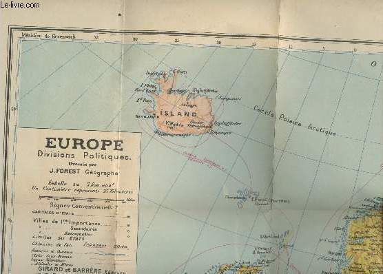
Collectif
"Carte de l'Europe au 7.500.000e (Série ""Les Nations"")"
Girard et Barrère. Non daté. In-Plano. En feuillets. Bon état, Couv. convenable, Dos satisfaisant, Intérieur frais. Une carte en couleurs dépliante au au 7.500.000e. Dimensions : 83 x 71 cm environs. Deux photos disponibles. . . . Classification Dewey : 912-Atlas, cartes et plans
Bookseller reference : RO20235824
|
|
|
COLLECTIF
"CARTE DU THEATRE DE LA GUERRE RUSSO-JAPONAISE (EN COULEURS) - DE DIMENSION 61 Cm X 45 Cm ENVIRON - Supplément publiée par ""Le Petit Journal""."
LE PETIT JOURNAL. NON DATE. In-Plano. En feuillets. Etat d'usage, Couv. convenable, Dos satisfaisant, Intérieur frais. 1 CARTE EN COULEURS DE DIMENSION 61 Cm X 45 Cm ENVIRON.. . . . Classification Dewey : 912-Atlas, cartes et plans
Bookseller reference : R320055464
|
|
|
COLLECTIF
"CARTE DU THEATRE ORIENTAL DE LA GUERRE. ""LA SCIENCE ET LA VIE""."
AU BUREAU DE LA REVUE. NON DATE. In-Folio. Broché. Etat d'usage, Couv. légèrement passée, Dos satisfaisant, Intérieur frais. Carte en couleurs de 45 x 60 cm. Fente au niveau d'un pli.. . . . Classification Dewey : 912-Atlas, cartes et plans
Bookseller reference : R260167562
|
|
|
Collectif
"Carte géographique pour pilotage aérien routes ""TFR"" espace intérieur 3è édition"
Service de l'information aéronautique France. 1987. In-Plano. En feuillets. Bon état, Couv. convenable, Dos satisfaisant, Intérieur frais. Carte de France en couleurs 75x60 cm environ.. . . . Classification Dewey : 912-Atlas, cartes et plans
Bookseller reference : R260199228

|
|
|
Collectif
"Carte IGN Nouvelle-Zélande - ""Pays découverte du monde"""
Institut national de l'information géographique et forestière. 2015. In-Plano. Broché. Bon état, Couv. convenable, Dos satisfaisant, Intérieur frais. Carte dépliante en couleurs.. . . . Classification Dewey : 912-Atlas, cartes et plans
Bookseller reference : R300303736

|
|
|
COLLECTIF
"CARTE LE ROYAUME D'ITALIE. ""LA SCIENCE ET LA VIE"" N°37, FEVRIER-MARS 1918"
AU BUREAU DE LA REVUE. 1918. In-Folio. Broché. Etat d'usage, Couv. légèrement passée, Dos satisfaisant, Intérieur frais. Carte en couleurs de 45 x 60 cm. Légères fentes en bordure.. . . . Classification Dewey : 912-Atlas, cartes et plans
Bookseller reference : R260167561
|
|
|
Collectif
"Carte originale de ""CARTE GENERALE DE GUYENNE"""
***. 17ème-18ème. In-Plano. Broché. Bon état, Couv. convenable, Dos satisfaisant, Intérieur frais. Carte originale, sur papier à la forme, (56/40 cm), délimitation des provinces en couleurs, tres légère tache sur le côté droit de la carte, échelle en Lieues.Renforcé sur le dos et les bords au dos.. . . . Classification Dewey : 912-Atlas, cartes et plans
Bookseller reference : RO20020312
|
|
|
COLLECTIF
"CARTE PLANISPHERE DE LA GUERRE MONDIALE ""1942"" - PROJECTION MERCATOR / ECHELLE A L'AQUATEUR 1/47.700.000è."
IMPRIMERIE INDUSTRIELLE - LILLE. VERS 1942. In-Plano. En feuillets. Etat d'usage, Couv. convenable, Dos satisfaisant, Intérieur acceptable. 1 très grande carte a déplier en couleur partiellement déchirée sans incidence sur la lecture.. . . . Classification Dewey : 912-Atlas, cartes et plans
Bookseller reference : R320014073
|
|
|
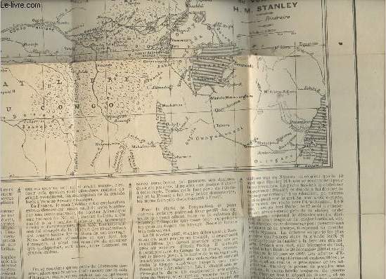
Collectif
"Carte pour suivre l'itinéraire du voyage de Stanley 1887-1889/ Echelle: 1.8900000- Supplément au journal ""Le Temps"" de Juin 1890"
Le temps. 1890. In-Folio. Broché. Etat d'usage, Livré sans Couverture, Dos satisfaisant, Papier jauni. 1 page illustrée d'une carte en noir et blanc avec un peu de texte. Déchirures altérant la lecture. Echelle: 1.8900000. . . . Classification Dewey : 912-Atlas, cartes et plans
Bookseller reference : RO30335809
|
|
|
Collectif
"De Paris à Marseille et à Cette- Routes pour automobiles (Collection ""Guides pratiques Conty"")"
Administration des guides Conty. Non daté. In-16. Cartonnage d'éditeurs. Bon état, Couv. convenable, Dos satisfaisant, Intérieur frais. Environ 300 pages. 41 cartes et plans en noir et blanc, dans et hors texte. Plan en noir et blanc, en frontispice.. . . . Classification Dewey : 912-Atlas, cartes et plans
Bookseller reference : RO30323183

|
|
|
COLLECTIF
"Dépliant ""Map of Denmark"""
THE NATIONAL TRAVEL ASSOCIATION OF DENMARK. Non daté. In-12. En feuillets. Bon état, Couv. convenable, Dos satisfaisant, Intérieur frais. Carte dépliante en couleurs, de 70 x 50 cm.. Echelle de 1 / 680000.. . . . Classification Dewey : 912-Atlas, cartes et plans
Bookseller reference : RO80151422
|
|
|
Collectif
"Ecrins (Alpes A6) : Le Bourg d'Oisans - Briançon - Parc National des Ecrins - Hiking map 1 : 50 000 (1cm=500m) - Collection : ""Carte de randonnées"""
Rando Editions. Non daté. In-Plano. En feuillets. Bon état, Livré sans Couverture, Dos satisfaisant, Intérieur frais. Une carte dépliante illustrée en couleurs. Hiking map 1 : 50 000 (1cm=500m). Environ 88 x 120cm. . . . Classification Dewey : 912-Atlas, cartes et plans
Bookseller reference : RO20231313

|
|
|
Collectif
"Europe Routière - Echelle 1/3.800000e (Collection : ""Cartes Blondel"")"
Blondel La Rougery. Non daté. In-Plano. Broché. Bon état, Couv. convenable, Dos satisfaisant, Intérieur frais. Envirion 100 x 80 cm. Carte en couleurs.. . . . Classification Dewey : 912-Atlas, cartes et plans
Bookseller reference : RO20213714

|
|
|
Collectif
"Grande-Bretagne (Collection ""Les Guides modernes Fodor"")"
Vilo. 1968. In-12. Relié. Bon état, Couv. convenable, Dos satisfaisant, Intérieur acceptable. 418 pages. 30 photos monochromes, 8 photos en couleurs, 16 cartes en couleurs hors texte. Jaquette en bon état.. Avec Jaquette. . . Classification Dewey : 912-Atlas, cartes et plans
Bookseller reference : RO80243961

|
|
|
Collectif
"Guide bleu France 1972 (Collection ""Les guides bleus"")"
Hachette. 1972. In-8. Relié. Bon état, Couv. convenable, Dos satisfaisant, Intérieur frais. 1333 pages. Contre-plats illustrés de cartes en couleurs. Nombreuses cartes en couleurs, dans le texte. Signet conservé. Jaquette et Rhodoïd abîmés.. Avec Jaquette. . . Classification Dewey : 912-Atlas, cartes et plans
Bookseller reference : RO30320088

|
|
|
COLLECTIF
"GUIDE DES OEUVRES D'ART ""La défense"""
. 1994. In-8. Broché. Bon état, Couv. convenable, Dos satisfaisant, Intérieur frais. 12 pages accompagnée d'un plan du quartier du parc en couleur.. . . . Classification Dewey : 912-Atlas, cartes et plans
Bookseller reference : R240016281
|
|
|
COLLECTIF
"L'ATLAS-INDEX DE TOUS LES THEATRES DE LA GUERRE - TOME 2 : PRUSSE, POLOGNE, GALICIE, HONGRIE. COLLECTION ""PAGES D'HISTOIRE 1914-1915."
BERGER LEVRAULT. NON DATE. In-8. Broché. Etat d'usage, Plats abîmés, Dos abîmé, Intérieur acceptable. 84 pages. 2 cartes d'ensemble en noir et blanc + 31 cartes détaillés en 3 couleurs.. . . . Classification Dewey : 912-Atlas, cartes et plans
Bookseller reference : ROD0107499
|
|
|
COLLECTIF
"LE THEATRE DES OPERATIONS MILITAIRES DANS L'AISNE ET EN CHAMPAGNE. CARTE EDITEE PAR ""LA SCIENCE ET LA VIE"" N°33, JUIN-JUILLET 1917."
AU BUREAU DE LA REVUE. 1917. In-Folio. En feuillets. Etat d'usage, Couv. légèrement passée, Dos satisfaisant, Intérieur frais. Carte de 58 x 47 cm à l'échelle 1/250.000 ème. Carte en couleurs.. . . . Classification Dewey : 912-Atlas, cartes et plans
Bookseller reference : R260120370
|
|
|
Collectif
"Madagascar (Collection ""Guides Gallimard"")"
Gallimard. 2000. In-8. Broché. Bon état, Couv. convenable, Dos satisfaisant, Intérieur frais. 312 pages. Nombreuses photos et illustration en couleur dans et hors texte. Signet conservé. . . . Classification Dewey : 912-Atlas, cartes et plans
Bookseller reference : RO80238413

|
|
|
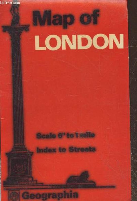
Collectif
"Map of London - Scale 6"" to 1 mile - Index to Streets- Tout pour le visiteur avec carte du metro en couleur (Echelle 1 : 10,560)"
Geographia. Non daté. In-Plano. En feuillets. Bon état, Couv. convenable, Dos satisfaisant, Intérieur frais. Carte en couleurs dépliante. Echelle 1 : 10,560. Dimensions environ 100/65cm. Légende en anglais, allemand, français.. . . . Classification Dewey : 912-Atlas, cartes et plans
Bookseller reference : RO20238062 ISBN : 92010407
|
|
 Receive by email
 Download as PDF document
 RSS feed


