|
Atlas de mapas antiguos de Colombia siglos XVI a XIX.
Litografia Arco. Bogota-Colombia, 1986, 187 p., 45x33cm, cartonnage éditeur, haut du premier plat froissé, coins supérieurs frottés, bon état pour le reste.
书商的参考编号 : 83107
|
|
|
Atlas der essbaren u. giftigen Pilze in natürlicher Grösse und Farbe mit Beschreibung, unter Gegenüberstellung der leicht zu verwechselnden Pilze - Teil I.
Annaberg, Grasers Vlg, o.J. 8°. 32 Bl. Mit 56 farb. Tafeln. Leinenband als Leporello gebunden.
书商的参考编号 : 17937AB
|
|
|
ATLAS d' HAITI
Centre d'Etudes de Géographie Tropicale et Université de Bordeaux 3.1985.In-4 à l'italienne.Très nombreuses cartes,schémas,photos en noir et en couleurs.BE.Couverture illustrée en couleurs.Fermeture cloutée.Dédicace du responsable de coordination à l'université "C.A.Girault" au Professeur Butel.2 coins émoussés.
书商的参考编号 : 42199
|
|
|
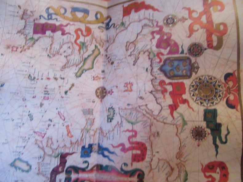
Atlas Universal. Diogo Homem. Texte et Atlas. Reprint.
Moleiro.2002.Texte in-4 de 331 pages toilé vert avec chemise illustrée en couleurs.Se trouvant dans un étui en carton imprimé. Atlas blond dans un étui fermé; intérieur moiré, de format in-folio.Etat neuf.Original en la Bibliothèque Nationale de Russie,à Saint-Pétersbourg.N°93/987.
书商的参考编号 : 46448
|
|
|
Atlas . 1885 - 1892.
Bibliographisches Institut, Meyers Konversations-Lexikon. gr. 8°, in Leinen neu gebunden, Titelblatt fehlt, es scheint der Atlasband des Lexikons zu sein, Bezahlung per PayPal möglich, we accept PayPal, Regalsp. a. Fußschn., altersbed. Bräunungen, ger. Gebr.sp., Leinen
书商的参考编号 : 32641
|
|
|
Atlas Antiquus Danvillianus Minor.
Norimbergae: Prostat in officina A.T. Schneideri-Weigeliana 1801. 13 Falttaf. mit 12 grenzkol. Kupferstichkarten, gest. Titelblatt 4° HLdr.d.Zt. *die Rückseiten der Karten sind von alter Hand betitelt*ebensolche Notizen und kleinere Flecken befinden sich auf dem Vorsatzpapier*Bindung etwas gelockert*Einband stärker berieben u. bestossen*Seiteneinriss in der 2. Taf.*.
书商的参考编号 : 98477
|
|
|
Atlas Basico de Canarias.
Santa Cruz de Tenerife., Editorial Interinsular Canaria., 1980. Primera edicion. 80 Seiten mit zahlreichen Karten, Zeichnungen und Tabellen. Zustand: Der Schutzumschlag ist leicht verfärbt und hat kleine Randeinrisse. Das Buch ist in gutem Zustand. 2°. OPappband mit OUmschlag.
书商的参考编号 : 060079
|
|
|
Atlas Braunschweig und Umgebung.
Braunschweig., Westermann Verlag, 1976. 32(1)S. mit zahlreichen Karten und einigen Luftbildern. Erste Ausgabe dieser Zusammenstellung. Guter Zustand. 4°. S OBroschur mit kl. Leinenstreif
书商的参考编号 : 059835
|
|
|
Atlas Braunschweig und Umgebung.
Braunschweig., Westermann Verlag, 1976. 32(1)S. mit zahlreichen Karten und einigen Luftbildern. Zustand: Innenkarton mit altem Schulstempel. 4°. S OBroschur mit kl. Leinenstreif
书商的参考编号 : 037654
|
|
|
ATLAS DE COLOMBIA. Hg. vom Geographischen Institut Agustin Codazzi unter der Leitung von Duardo Acevedo Latorre.
Luxuriöse, womöglich für einen Staatsbesuch eigens gebundene Ausgabe mit Widmung des kolumbianischen Staats- und Regierungschefs Carlos Lleras Restrepo an den österreichischen Bundespräsidenten Franz Jonas: “Para S. E. il señor Presidente de Austria, con la admiracion y la cordial amisdad del pueblo columbiano.” Der Atals enthält hunderte farbige, teils photographische Abbildungen, Karten, Diagramme und Pläne sowie ausführliche Beschreibungen u. a. aus den Bereichen Kosmographie, Astronomie, historischer Kartographie, der Geographie betreffend Fauna, Flora und Ethnien und detailierten Karten der diversen kolumbianischen Provinzen. - Titelblatt mit Bibliotheksstempel und -vermerk, Hinterdeckel mit Schadstellen, sonst sauberes Exemplar.
|
|
|
Atlas der essbaren u. giftigen Pilze in natürlicher Grösse und Farbe mit Beschreibung, unter Gegenüberstellung der leicht zu verwechselnden Pilze - Teil I.
Annaberg, Grasers Vlg, o.J. 8°. 32 Bl. Mit 56 farb. Tafeln. Leinenband als Leporello gebunden. + Wichtig: Für unsere Kunden in der EU erfolgt der Versand alle 14 Tage verzollt ab Deutschland / Postbank-Konto in Deutschland vorhanden +
书商的参考编号 : 17937AB
|
|
|
Atlas der Schweiz. Redaktionelle Leitung: Eduard Imhof.
Bern, Eidgenössische Landestopographie, 1965-1978. 97 gefaltete Tafeln in Mappen, ca. 400 Karten und Detailkarten; transparente Ortsnamenkarte der Schweiz auf 4 Folien, Diagramme und Tabellen. Kst.Ldr.-Kassette, 76 x 51,5 cm. Thematisches Kartensammelwerk über Natur, Geschichte, Bevölkerung, Wirtschaft, Verkehr, Sozialstrukturen usw. Die Rückseiten der Tafeln enthalten Erläuterungstexte in deutscher, französischer und italienischer Sprache. Vollständige Ausgabe, aller Blätter in erster Auflage und in den Original-Liefermappen. Dem Atlas liegt ein erweiterter Vorabdruck des Kartenblattes Winterthur 1922-1972 bei mit einer Widmung von Eduard Imhof: "Meinem lieben Dr. Paul Gysi / ein Gruss aus Winterthur und alle / guten Wünsche von einem Erlenbacher / Ihr E. Imhof. 8. Sept. 72" sowie eine Seminararbeit zum Atlas der Schweiz von C. Schmid, C. Erdin und M. Dieterlé mit einer Widmung. Das Werk wurde ein Opfer der Digitalisierung und blieb deshalb unvollendet. Was hierfür noch in mühsamer Handarbeit ermittelt und dann auf Karten übertragen wurde, sucht man in neuen Atlanten heute vergeblich. Der letzte grosse Schweizer Atlas. Hardcover Mappen mit Klebern und handschriftlichen Anmerkungen, Karten und Kassette tadellos.
书商的参考编号 : 122567
|
|
|
Atlas Du Voyage Du Jeune Anacharsis En Grece. Dessine par Charles Monin, et grave par les freres Malo.
A Paris, Au Bureau des Editeurs 1830. Quer-8°. Vort., Titelbl., 2 nn. Bll., 35 gest., teilw. gef., Kt u. Taf., 1 nn. Bl. (Table des Planches), Karten meist grenzkoloriert, mit e. Titelblattvignette (Bienenkorb). Halblederband d. Zeit, zwei Rückenschildchen und Rückenverzierung goldgeprägt, Einbanddeckel braun marmoriert, Lesebändchen, bestoßen, Karten u. Tafeln zusammengeheftet, Einbanddeckel locker. Blätter, Tafeln u. Karten großteils braunfleckig. Goffart. Historical Atlases 541. Vgl. Michaud III,179ff. - Kartenwerk zum 1788 erstmals erschienenen mehrbändigen Reiseroman des Jean-Jacques Barthelemy (1716-1795), basierend auf Überlieferungen über den Skythen Anacharsis, Vorsokratiker, der 600 v. Chr. eine Entdeckungsreise durch Griechenland unternommen haben soll. Bereits zur ersten, wie auch zu den späteren Ausgaben der 'Reise des jungen Anacharsis' wurde ein begleitender Atlas herausgegeben, der entsprechende Atlas des Kartographen Charles V. Monin (gest. 1880) erschien 1830 bis 1840. Vollständiges Exemplar dieser seltenen Ausgabe. [3 Warenabbildungen]
书商的参考编号 : KART0211

|
|
|
Atlas Friedrichs des Großen. Die friderizianische Zeit im Spiegel alter Karten. Limitierte Auflage, Nr. 0627 / 0999
Braunschweig, Archiv Verlag, 2004. 24 faksimilierte farbige Karten auf Kartonbögen, jeweils mit 1 Textbogen 43 x 51 cm quer. Blauer OKunstledereinband.
书商的参考编号 : 30730
|
|
|
Atlas für Bürgerschulen und für sieben- und achtclassige allgemeine Volksschulen. Siebte Auflage
Wien, Verlasg der kaiserlich-königlichen Hof- und Staatsdruckerei, 1898. o. S. 4° Quart, Hardcover/Pappeinband
书商的参考编号 : 82158

|
|
|
Atlas für Hambuger Schulen, 1. Teil: Unsere Heimat.
Westermann, Braunschweig. 1960. 28 S. 32*24 cm. OHalbleinenband.
书商的参考编号 : 148147

|
|
|
Atlas für Hamburger Schulen. 2 Teile in 1 Band: TEIL 2: Deutschland / Europa und die übrigen Erdteile. TEIL 3: Zahlen aus Heimat und Welt. Bearbeitet u. hrsg. v. Ausschuß f. Erdkunde in der Gesellschaft der Freunde des vaterländischen Schul- und Erziehungswesens zu Hamburg.
Braunschweig, Georg Westermann, 1964. 56, meist farb. KartenS.; 27 S. Mit 3 S. m. farb. astronom. Illustr. u. 2 farb. Himmelskarten, einigen s/w Karten u. zahlr. Diagrammen u. Tabellen (= Westermann-Atlas 10905). 32 cm. OHLn.
书商的参考编号 : 92157

|
|
|
Atlas Histórico Y Geográfico de Africa Espanola.
Madrid., 1955. Dirección General De Marruecos Y Colonias E Instituto De Estudios Africanos. 197 Seiten, mit 47 farbigen, neist doppelseitigen Karten. Zustand: Aus einer Bibliothek ausgeschieden, Einbandkanten minimal berieben, unterer Rücken mit Kleberesten (eines entfernten Bibliotheksschildes), Stempel auf vorderen , unteren Einbanddeckel und auf Vortitelblatt. 2°. OLeinen.
书商的参考编号 : 041110
|
|
|
Atlas international. Die grosse Bertelsmann-Lexikothek.
Gütersloh : Bertelsmann-Lexikothek-Verl., 1989. 464 S. : zahlr. Ill. u. Kt., 36 cm. gebundene Ausgabe, Kunstleder, Goldpräg., Lesebändchen.
书商的参考编号 : 239182

|
|
|
Atlas Larousse illustré - France et Colonies Françaises (Départements français & Colonies " Algérie, Tunisie, La Réunion, Madagascar, Colonies d'Afrique, d'Amérique et d'Asie "
PARIS, Larousse - SD (vers 1900) - 1 ère partie - Reliure demi-chagrin rouge d'époque (frottée) - Dos à nerfs ornés - Toutes tranches dorées - Page de garde avec mention en lettres dorées "Prix offert par le préfet de la Seine au nom du conseil Général" - 158 pages - Orné de 17 cartes HT en couleurs et de 463 reproductions photographiques in-texte - Envoi rapide et soigné ; une quarantaine de pages sont consacrées aux colonies " Algérie, Tunisie, La Réunion, Madagascar, les colonies d'Afrique, d'Amérique et d'Asie " illustrées de photographies très intéressantes ; Bel atlas dans un bon état de fraicheur In-4.
|
|
|
ATLAS MIASTA KRAKOWA. (Atlas of the city of Cracow).
Warszawa, Panstw. Przeds. Wyd. Kartograficznych, 1988. 43,5 x 35,5 cm. 6 Blätter Text u. 47 grosse, gefalt. Pläne. Lose Blätter in illustr. OHlwd.-Mappe. - Polnischer Text. - Sehr gutes Ex.
书商的参考编号 : 95645AB
|
|
|
Atlas of Illinois Resources. Section 6: Agriculture in the Illinois Economy.
Urbana, Illinois., 1962. Editor: University of Illinois, College of Agriculture, Agricultural Experiment Station, Cooperative Extension Service, Louis B. Howard, Dean and Director. 82 Seiten, mit zahlreichen Wirtschaftskarten und Erläuterungen. Zustand: Aus einer Institutsbibliothek ausgeschieden, Einbandbroschur, Titelblatt und Seite 3 mit Bibliotheksstempel. 4°. OSpiralbindung.
书商的参考编号 : 044756
|
|
|
ATLAS OF THE WORLD - London 2000 - Muy ilustrado
London, Times Books, 2000. Numerosas ilustraciones en color. 240p. 8º mayor. Cartoné editorial con sobrecubierta ilustrada. Muy buen ejemplar.
|
|
|
Atlas Regierungsbezirk Braunschweig.
Braunschweig ., Westerman Verlag., 1985. 32 Seiten mit ca. 40 Karten. Guter Zustand. 4°. S OBroschur / Okarton.
书商的参考编号 : 039052 ???????? : 314100062
|
|
|
Atlas von Württemberg und Hohenzollern.
Bln/..., Hillger, (1900). Mit einem geographischen Lexikon. Bearbeitet von Joseph Kürschner (lexikalischer Teil) und Christian Peip (kartographischer Teil). Mit 37 doppelseitigen, farbigen Karten und 10587 Artikel. Einleitung: Julius von Hartmann. 8°. VI,2,694,5 S. + 37 doppelseitige Karten. Neuer OKunstlederband unter Verwendung des ill. OVorderdeckels und mit montiertem Rückenschildchen (Ausschnitt aus dem ORücken). Schmuckvorsatz. Papier vom Text etwas gebräunt, vereinzelt kleine Fleckchen. Gering gebraucht.
书商的参考编号 : 16054

|
|
|
AutoRoute Express Europe [Europa]. : the Complete European Route Planner and Travel Guide.
o.O. : Microsoft, 1997. + Beiheft in Dt., Engl., Franz. (je 15 S.). CD-Format. 1997 ed.
书商的参考编号 : 8598
|
|
|
AYDIN V?LAYETI TAKS?MAT-I MÜLK?YE VE TOPOGRAFYA HARITASI [Aydin Province Provincial Division and Topography Map]. Chromolithograpic map in 4 sheets with with typographical title cartouche, pictorial legend and geographic coordinates, all with Ottoman Turkish text.
Large sized topographical map in striking colours and Ottoman Turkish text of one of the core provinces of the Ottoman Empire around 1900. – Content: Present detailed administrational and topographical map incorporates ground relief (landforms and terrain), drainage (the Aegian Sea, lakes and rivers), forest cover, administrative areas, populated areas (towns and villages in great detail), transportation routes, roads and railways. The Ottoman Ayd?n Province, named after the district and provincial capital Ayd?n, was established by the Ottoman authorities with the »Te?kil-i Vilayet Nizamnamesi« (Provinces Regulations Act) dated 1864 and consisted of ?zmir Central Sanjak (district), Ayd?n Sanjak, Saruhan Sanjak (added in 1877) and Mente?e Sanjak (until 1908). The ?zmir Sanjak is of particular historical importance, as it incorporated not only the historically, economically and culturally important city of Smyrna (?zmir), the second biggest urban agglomeration of the Aegian region after Athens, but also numerous unique ancient sites, foremost the Greek and Roman city of Ephesus. – Condition: Sheets in parts with minor staining, margins skilfully restored tears, otherwise in good condition.
|
|
|
Barnstaple and Ilfracombe : Lynton & Bideford...
Ordnance Survey, 2009. Gr. 8°. D2 Folded map. (OS Landranger Map ; 180) (Landranger Map)
书商的参考编号 : 35319
|
|
|
Berlin.
Darmstadt : Wiss. Buchges., [Abt. Verl.]; Gotha : Haack, 1990. e. geograph. Strukturanalyse d. 12 westl. Bezirke / von Burkhard Hofmeister. [2., vollst. überarb. Aufl.] - Bd 2.: Berlin (Ost) u. sein Umland / hg. von Alfred Zimm. - 3., durchges. Aufl. - Bd 3: Beih. / mit e. Vorw. von Walter Momper. XI, [II], 311 S., [8] Taf. + 2 Faltkt. in Kt.-Tasche; 369 S., [30] Taf. : Ill., Kt. + 3 Faltkt. in Kt.-Tasche; II, 14 S. : Kt. - 24 cm Gr. 8°. 3 Bde: Bd 1.: Berlin (West) : Bundesrepublik Deuts OPpbd. mit SU; 2 Bde im OSchuber (Kassette). (Wissenschaftliche Länderkunden ; 8) (Petermanns Geographische Mitteilungen : Ergänzungsheft ; 286)
书商的参考编号 : 19555
|
|
|
BERLIN. [Innenstadt bzw. Großberlin vom Mittelallter bis zum Viermächte-Abkommen 1972.] 18 mehrfarbig bedruckte, transparente Folien für Overhead-Projektoren. Hg. v. Werner Hilgemann und Günther Kettermann. (= Perthes-Transparent-Atlas. Hauptstädte und Weltstädte in Vergangenheit und Gegenwart, Serie 9210)
Die Folien zeigen die Innenstadt Berlins vom Mittelalter bis 1945 (5x), die Kriegsschäden, das Stadtbild und die "Gespaltene Stadt nach dem II. Weltkrieg" (2x), weiters die Bezirke und das Stadtbild Groß-Berlins von 1920-1970 (3x), den "Endkampf um Berlin 1945", die Sektoren 1945/49, Blockade und Luftbrücke 1948/49, Berlin "vom Mauerbau 1961 zum Viermächte-Abkommen 1972" sowie die Bevölkerungsbewegungen 1970/71. - Verlagsfrisches Exemplar.
|
|
|
Bertelsmann - der große Autoatlas : Deutschland und Europa 2004/2005. Deutschland 1:250000, europäische Nachbarländer, Österreich, Schweiz 1:400000, Europa 1:4,5 Millionen, Innenstadtpläne, Ballungsraumkarten ; aktualisierte Kartografie für sichere Routenplanung, umfangreiches Register.
Gütersloh ; München : Wissenmedia GmbH; Gütersloh ; München : Wissen-Media-Verl., 2004. 444 S. 30 cm + Kt. gebundene Ausgabe, Pp.
书商的参考编号 : 236410

|
|
|
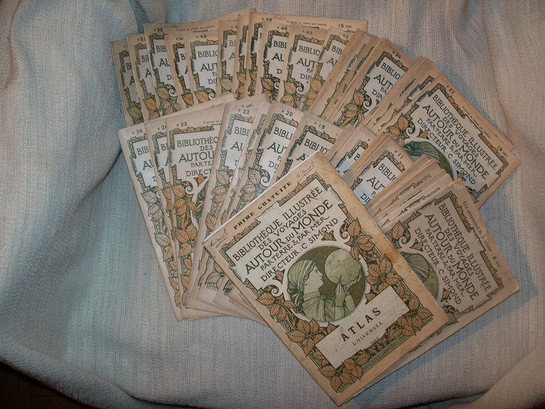
BIBLIOTHEQUE ILLUSTREE des Voyages autour du monde par terre et par mer. Parution hebdomadaire. 1re année numéros 1 à 52 et Atlas Universel.
Paris Plon 1898. 52 fascicules (21,5cm sur 14,5cm) 32pp chacun, brochés couverture illustrée en couleurs d'un décor de végétaux avec médaillon central allégorique. Orné de nombreuses illustrations et cartes dans le texte et à pleine page. L'atlas, aux dimensions identiques à celles des fascicules, broché avec couverture illustrée de même, se compose de 32 planches en couleurs: les planches XVI-XVII représentent un plan de Paris sur double page, les planches XV et XVIII réunissent 8 petits plans de villes (Le Havre, Rouen Lille, Brest, Lyon, Marseille, Bordeaux, Toulouse), les autres planches présentent des cartes de toutes les parties du monde (certaines avec un petit plan de leur capitale). Petit manque angulaire sur le 2e plat de couverture et le dernier feuillet du fascicule n°4, petite coupure sans manque au bas du 2e plat de couverture du fascicule n°30, rousseurs sur le 1er plat de la couverture et la page de titre de l'Atlas. L'ensemble, malgré ces défauts, est frais, chaque fascicule est complet, l'année est complète avec son rare atlas qui était offert aux souscripteurs de la collection.
书商的参考编号 : GITg692
|
|
|
Bibliotheca cartographica / hg. von d. Bundesanst. für Landeskunde... - [Mitarb.]: K. H. Meine...
Bonn-Bad Godesberg : Bundesanst. für Landeskunde, 1957 - 1963. Getrennte Zählung. - 21 x 15 x 6,5 cm. 8°. Zugl. Beih. zu "Berichte zur deutschen Landeskunde HLwd. d. Zt. mit verstärkten Ecken u. Rückengoldpräg.
书商的参考编号 : 28165
|
|
|
Bibliotheca cartographica : Bibliographie des kartographischen Schrifttums... / hg. von d. Bundesanst. für Landeskunde... - [Mitarb.]: K. H. Meine...
Bonn-Bad Godesberg : Bundesanst. für Landeskunde, 1963 - 1971. Getrennte Zählung. - 21 x 15 x 6,5 cm. 8°. Zugl. Beih. zu "Berichte zur deutschen Landeskunde OBroschur.
书商的参考编号 : 28831
|
|
|
Big Road Atlas Britain
Folio, 69 pages, scale 4 miles to the inch. eng
|
|
|
Bilder-Atlas der Schweiz. Sammlung von Landschafts-, Städte- und Typenbildern aus allen Kantonen mit Erklärendem Text zusammengestellt durch die Mitarbeiter am ‘Geographischen Lexicon der Schweiz’.
Paris / Neuenburg, Verlag Gebrüder Attinger, o. J. (ca. 1909), gr. in-4to, 476 S., mit ungefähr 3300 Abbildungen, roter Original-Leinwandband nach dem künstlerischen Entwurf von Grasset.
书商的参考编号 : 88752aaf
|
|
|
Bilder-Atlas der bayerischen Geschichte.
Nürnberg, Carl Koch's Verlagsbuchhandlung, 1901. 51 S. Gr.-8° Groß-Oktav, Halbleinen
书商的参考编号 : 103147

|
|
|
Blumen-Atlas. Herausgegeben unter Mitwirkung des botanischen Museums Berlin-Dahlem. 1. bis 20. Lieferung. (12 Mappen, Die . Lieferungen 7., 10., 11., 12., 15., 17., 19. und 20 fehlen). Verkauf Pro Lieferung
Berlin-Grunewald, F. A. HErbig Verlagsbuchhandlung 1950-54, in-8vo, 15 Tafeln pro Mappe mit Blumen- und Pflanzendarstellungen in originalgetreuer Wiedergabe nach Aquarellen der besten Blumen- und Pflanzenzeichner. Original-Pappband illustr. PRO LIEFERUNG
书商的参考编号 : 86789aaf
|
|
|
Canadian Railways. Chemins de Fer Canadiens. Atlas. The Railway Association of Canada. L'Association des chemins de fer du Canada. RAC / ACFC.
1991. 68 Seiten; Karten (farbig); graph. Darst.; 28 cm; geheftet.
书商的参考编号 : 1244253

|
|
|
Carte générale des routes des chemins de fer et des principales voies navigables de l'Europe - 1858
Paris Andriveau-Goujon 1858 Sous portefeuille pleine percaline verte Grand In8 - Entoilée en 32 panneaux - Imprimerie de Chardon - gravée par Rousset - Dépliée fait 102 x 84 cm - bel état .
书商的参考编号 : Arm229
|
|
|
Carte Marine Du Goulet de Fromentine à l'ile d'Yeu - Levée en 1822 - éditée en 1922
0 Carte 106 X 75 cm , 89 X 59 cm a l'intérieur du cadre - déchirures nombreuses en bordures n'affectant pas la carte -
书商的参考编号 : Marine1

|
|
|
Carte Marine Du Goulet de Fromentine à l'ile d'Yeu - Levée en 1822 - éditée en 1922
0 Carte 106 X 75 cm , 89 X 59 cm a l'intérieur du cadre - déchirures nombreuses en bordures n'affectant pas la carte -
书商的参考编号 : Marine1
|
|
|
Carte Marine Environs de Saint Gilles sur Vie , partie Orientale de l'ile d'Yeu - Levée en 1822 édition 1903
0 Carte 106 X 75 cm , 89 X 59 cm a l'intérieur du cadre - déchirures nombreuses en bordures n'affectant pas la carte - Nombreuses annotations au stylo bleu ou rouge faites trés proprement ( mouillages et calculs )
书商的参考编号 : Marine2
|
|
|
Carte Marine Sardaigne - édition 1897
0 Carte 106 X 75 cm , 90 X 61 cm a l'intérieur du cadre - déchirures nombreuses en bordures n'affectant pas la carte - Fortes rousseurs débordant sur la légende .
书商的参考编号 : Marine3
|
|
|
Carte Marine Sardaigne - édition 1897
0 Carte 106 X 75 cm , 90 X 61 cm a l'intérieur du cadre - déchirures nombreuses en bordures n'affectant pas la carte - Fortes rousseurs débordant sur la légende .
书商的参考编号 : Marine3
|
|
|
Carte Marine Des Roches de Porsal à l'ile de Sein- édition 1892
0 Carte 106 X 75 cm , 90 X 61 cm a l'intérieur du cadre - déchirures nombreuses en bordures n'affectant pas la carte - quelques déchirures aux plis . Sera envoyée pliée . .
书商的参考编号 : Marine4

|
|
|
Carte Marine Des Roches de Porsal à l'ile de Sein- édition 1892
0 Carte 106 X 75 cm , 90 X 61 cm a l'intérieur du cadre - déchirures nombreuses en bordures n'affectant pas la carte - quelques déchirures aux plis . Sera envoyée pliée . .
书商的参考编号 : Marine4
|
|
|
CARTES DE MOBILISATION. LOT INDIVIDUEL. FRANCE 200.000°. A N'OUVRIR QU'A LA MOBILISATION.
PARIS. SERVICE GEOGRAPHIQUE DE L'ARMEE. 1923. 11 CARTES DE FRANCE ET DES FRONTIERES EN COULEURS, TYPE 1912 (65 X 55 CENTIMETRES ENVIRON) REPLIEES SOUS ETUI PAPIER D'ORIGINE (28 X 18 X 1,5 CENTIMETRES ENVIRON). CONTIENT : COBLENTZ, COLOGNE, LIEGE, LONGWY, MAYENCE, METZ, MULHOUSE, NANCY, SAVERNE, STRASBOURG ET VESOUL. BON ETAT.
书商的参考编号 : 2832
|
|
 ?????????
 ?????PDF???
 RSS feed


