|
Astronomie - Encyclopédie ATLAS Du Ciel
Astronomie - Encyclopédie ATLAS Du Ciel - Volume 32
Editions Atlas brochure 1983 32 pages en format 22 - 29 cm - photos en couleurs
Bookseller reference : 017680
|
|
|
Astronomie - Encyclopédie ATLAS Du Ciel
Astronomie - Encyclopédie ATLAS Du Ciel - Volumes 37+38+39
Editions Atlas brochure 1983 32*3 pages en format 22 - 29 cm - photos en couleurs
Bookseller reference : 017681
|
|
|
Astronomie - Encyclopédie ATLAS Du Ciel
Astronomie - Encyclopédie ATLAS Du Ciel - Volume 51
Editions Atlas brochure 1984 32 pages en format 22 - 29 cm - photos en couleurs
Bookseller reference : 017682
|
|
|
Astronomie - Encyclopédie ATLAS Du Ciel
Astronomie - Encyclopédie ATLAS Du Ciel - Volume 55
Editions Atlas brochure 1984 32 pages en format 22 - 29 cm - photos en couleurs
Bookseller reference : 017683
|
|
|
Astronomie - Encyclopédie ATLAS Du Ciel
Astronomie - Encyclopédie ATLAS Du Ciel - Volume 66
Editions Atlas brochure 1984 32 pages en format 22 - 29 cm - photos en couleurs
Bookseller reference : 017684
|
|
|
Astronomie - Encyclopédie ATLAS Du Ciel
Astronomie - Encyclopédie ATLAS Du Ciel - Volumes 69 à 76
Editions Atlas brochure 1984 32*8 pages en format 22 - 29 cm - photos en couleurs
Bookseller reference : 017685
|
|
|
Astronomie - Encyclopédie ATLAS Du Ciel
Astronomie - Encyclopédie ATLAS Du Ciel - Volume 80
Editions Atlas brochure 1984 32 pages en format 22 - 29 cm - photos en couleurs
Bookseller reference : 017687
|
|
|
Astronomie - Encyclopédie ATLAS Du Ciel
Astronomie - Encyclopédie ATLAS Du Ciel - Volumes 13+14
Editions Atlas brochure 1983 32*2 pages en format 22 - 29 cm - photos en couleurs
Bookseller reference : 017691
|
|
|
Astronomie - Encyclopédie ATLAS Du Ciel
Astronomie - Encyclopédie ATLAS Du Ciel - Volumes 16 à 19
Editions Atlas brochure 1983 32*8 pages en format 22 - 29 cm - photos en couleurs
Bookseller reference : 017692
|
|
|
ASTON CLAIRE- HARRIS NICHOLAS- TURNER JOANNA- ...
L'atlas du monde - Le monde en images
SUCCES DU LIVRE.. 2002. In-4. Relié. Etat d'usage, Couv. convenable, Dos satisfaisant, Quelques rousseurs. 64 pages augmentées de nombreuses illustrations en couleurs dans le texte - petit accroc au dos. . . . Classification Dewey : 912-Atlas, cartes et plans
Bookseller reference : RO20261409

|
|
|
Aston, Mick und Tim Taylor
Atlas Archäologie Die faszinierende Welt unserer Vorfahren
München: Ullstein Heyne List GmbH & Co.KG., 2004. Lizensausgabe by Paletti 207 Seiten , 30 cm, Pappeinband
Bookseller reference : 7222

|
|
|
ASTRONOMY ATLAS. BURRITT Elijah H.
Atlas designed to illustrate the geography of the heavens comprising the following maps or plates. . . .
New York: Published by Huntington and Savage 216 Pearl St. 1835. Imperial 4to. 16 x 14 in. 10 leaves 8 engraved plates 2 double-page 7 hand-coloured minor foxing edgewear faint tidemark to lower margin of first few leaves. Original printed yellow softcovers mounted on thicker paper stock cover art woodcut of astronomer gazing at the stars w/ telescope testimonials printed on back cover soiling edgewear rubbing tide-mark to lower margin bumping to corners pencil drawings by child on verso of some plates trying to reproduce some of the figures still G copy. First edition thus stated “New Edition†which in actuality was an updated and revised edition with new engraved plates executed by W.G. Evans of New York fl. 1830-1845 who also engraved the famed Map of Lewis & Clark’s Track Across the Western Portion of North America in 1842 revised by Archibald M’Vickar. Burritt 1794-1838 an American astronomer and mathematician created his textbook and the later atlas as a low-cost alternative to celestial globes which were often too expensive for many schools in Jacksonian America. The atlas could be purchased for $ 1.25 at the time and the Geography of the Heavens textbooks and Atlases would prove immensely popular in classrooms up until 1876. Adapting most of his constellation figures from Alexander Jamieson’s A Celestial Atlas 1822 Burritt included a plan of the Solar System Celestial maps of the skies in January-March October-December April-June July-September South Pole North Pole and Planisphere of the Whole Heavens on Mercator’s Projection. This was the last decorative celestial reference in the 19th century and even served as inspiration of H.P. Lovecraft who notes it as prized possession in letter to Maurice Moe in 1915. See: Kidwell Elijah Burritt and the Geography of the Heavens Sky & Telescope Vol. 69 January 1985 pp. 26-28; Boston University Art Gallery Celestial Images: Antiquarian Astronomical Charts and Maps from the Mendillo Collection 2005 75. Published by Huntington and Savage, 216 Pearl St., paperback
Bookseller reference : 53619
|
|
|
ATA ATUN.
Names of the locations of Cyprus lost in the depths of 2500 years of history and a bilingual (Greek-Turkish) map written in Roman script.= Kibris'in 2500 yillik geçmisinde tarihin derinliklerinde kaybolmus yer isimleri ve Latin harfleri ile iki dilde (Türkçe-Rumca) yazilmis yer haritasi.
As New English Paperback. Roy. 8vo. (24 x 17 cm). In English and Turkish. [xvii], [1], 122 p., 1 folding huge map. Names of the locations of Cyprus lost in the depths of 2500 years of history and a bilingual (Greek-Turkish) map written in Roman script.= Kibris'in 2500 yillik geçmisinde tarihin derinliklerinde kaybolmus yer isimleri ve Latin harfleri ile iki dilde (Türkçe-Rumca) yazilmis yer haritasi.
|
|
|
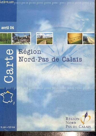
Atelier de cartographie du Conseil Régional
Carte région Nord-Pas de Calais
Région Nord Pas de Calais. 2004. In-8. Broché. Bon état, Couv. convenable, Dos satisfaisant, Intérieur frais. Carte dépliante en couleurs, 60x90 cm. Echelle : 1cm = 2,5km.. . . . Classification Dewey : 912-Atlas, cartes et plans
Bookseller reference : RO80241131
|
|
|
ATELIER BORDELAIS DE CARTOGRAPHIE
Plan de Bordeaux Metropole. Grands Axes - Grands Equipements.
BORDEAUX METROP0LE. Janvier 1996. In-12. En feuillets. Bon état, Couv. convenable, Dos satisfaisant, Intérieur frais. Plan dépliant en couleurs, de 60 x 90 cm.. . . . Classification Dewey : 912-Atlas, cartes et plans
Bookseller reference : RO80153123
|
|
|
ATLAS
"Fantômes; manifestations et apparitions. "
Paris, Editions Atlas, 1996. 12 x 18, 126 pp., plusieurs illustrations en N/B, broché, bon état.
Bookseller reference : 62636
|
|
|
ATLAS - SEUTTER, (MATTHAEUS).
(Atlas Minor) - Atlantis Minoris...
Augsburg, Augustæ Vind, (1744). 4to-oblong. Cont. hcalf. Back and covers somewhat worn. Platesizes ca. 20,5 x 27 cm. (32) pp. and 60 full-page engraved maps (of 64 listed). Lacking the engraved title and 5 other maps (Africa, America septentrionalis, Regum Portugalliæ, Regnum Hispaniæ, Italia totur and Palæstina), but having 2 more not listed and some in the German section does not corresponds with the maps listed in the index. All maps in original handcolouring, occasionally a little brownspotted and traces of use in lower right corners. One map have a little loss of image in lower middle (Austria Saliburgensis).
Bookseller reference : 20097
|
|
|
ATLAS. SUPPLÉMENT DES GUIDES BLEUS.-
30 cartes des Environs de Paris. Est.-
Paris. Hachette. Sans date. Petit in-4 (206 x 204 mm) cartonnage dos toile bleue de l'éditeur, 32 cartes en couleurs, accompagnées de commentaires en vis à vis illustrés de photos formant un dictionnaire des communes. Tableau d'assemblage en frontispice. Petits défauts d'usage mais bon exemplaire.
Bookseller reference : ORD-18765
|
|
|
ATLAS. SUPPLÉMENT DES GUIDES BLEUS.-
30 cartes des Environs de Paris. Ouest.-
Paris. Hachette. Sans date. Petit in-4 (206 x 204 mm) cartonnage dos toile bleue de l'éditeur, 32 cartes en couleurs, accompagnées de commentaires en vis à vis illustrés de photos formant un dictionnaire des communes. Tableau d'assemblage en frontispice. Petits défauts d'usage mais bon exemplaire.
Bookseller reference : ORD-18766
|
|
|
ATLAS des PORTS de FRANCE.
[ALGÉRIE/GHAZAOUET & MERS-EL-KÉBIR] I. Nemours - II. Mers-El-Kébir.
1888. 580 x 383 mm.
Bookseller reference : LBW-4913

|
|
|
ATLAS des PORTS de FRANCE.
[ALGÉRIE/BENI SAF] Port de Beni-Saf.
1889. 406 x 548 mm.
Bookseller reference : LBW-4914

|
|
|
ATLAS des PORTS de FRANCE.
[ALGÉRIE/ARZEW] Port d'Arzew.
1889. 415 x 556 mm.
Bookseller reference : LBW-4916

|
|
|
ATLAS des PORTS de FRANCE.
[ALGÉRIE/TÉNÈS] Port de Ténès.
1889. 577 x 372 mm.
Bookseller reference : LBW-4917

|
|
|
ATLAS des PORTS de FRANCE.
[ALGÉRIE/DELLYS] Port de Dellys.
1891. 571 x 358 mm.
Bookseller reference : LBW-4918

|
|
|
ATLAS des PORTS de FRANCE.
[ALGÉRIE/JILEL] Port de Djidjelli.
1890. 386 x 539 mm.
Bookseller reference : LBW-4921

|
|
|
ATLAS des PORTS de FRANCE.
[ALGÉRIE/STORA & SKIKDA] I. Stora - II. Philippeville - III. Carte de la baie de Philippeville.
1892. 587 x 840 mm.
Bookseller reference : LBW-4923

|
|
|
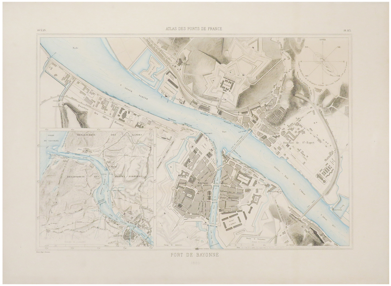
ATLAS des PORTS de FRANCE.
[BAYONNE] Port de Bayonne.
1886. 405 x 537 mm.
Bookseller reference : LBW-6656
|
|
|
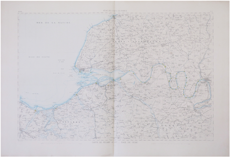
ATLAS des PORTS de FRANCE.
[BAIE de SEINE] Carte de Fécamp à Luc. - Baie de Seine.
1878 573 x 827 mm.
Bookseller reference : LBW-6766
|
|
|
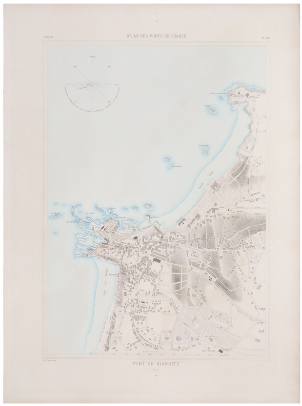
ATLAS des PORTS de FRANCE.
[BIARRITZ] Port de Biarritz.
1885. 558 x 378 mm.
Bookseller reference : LBW-6670
|
|
|
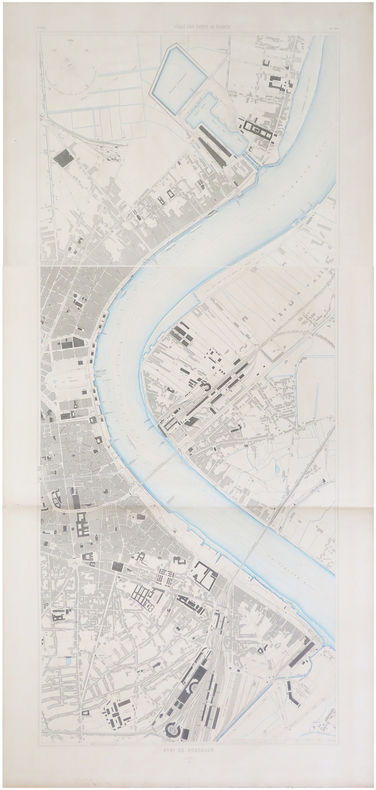
ATLAS des PORTS de FRANCE.
[BORDEAUX] Port de Bordeaux.
1886. En deux feuilles pouvant être jointes pour former un plan de 1,28 x 0,54 m.
Bookseller reference : LBW-6672
|
|
|
ATLAS des PORTS de FRANCE.
[BOULOGNE-sur-MER] Port de Boulogne.
1872. 415 x 533 mm.
Bookseller reference : LBW-6762

|
|
|
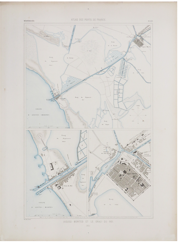
ATLAS des PORTS de FRANCE.
[CAMARGUE] Aigues-Mortes et Le Grau-du-Roi.
1891. 570 x 356 mm.
Bookseller reference : LBW-6498
|
|
|
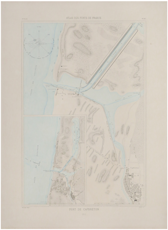
ATLAS des PORTS de FRANCE.
[CAPBRETON] Port de Capbreton.
1881. 573 x 360 mm.
Bookseller reference : LBW-6648
|
|
|
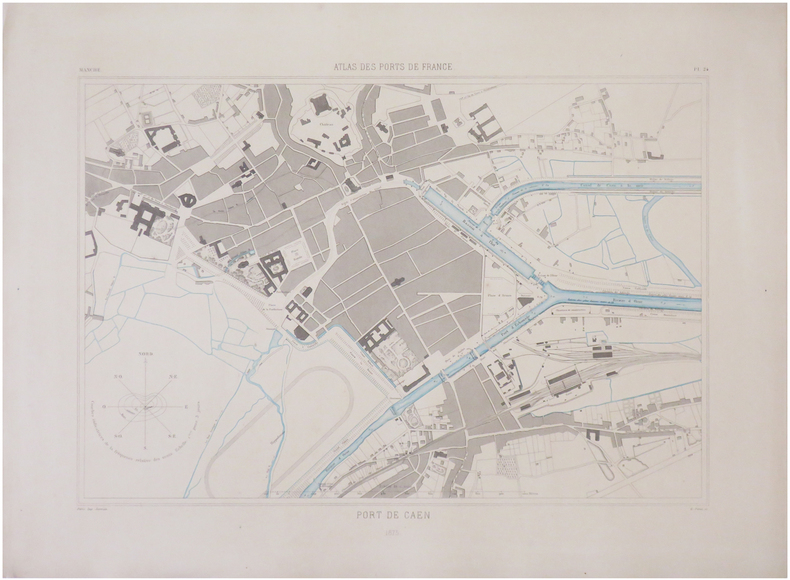
ATLAS des PORTS de FRANCE.
[CAEN] Port de Caen.
1875. 395 x 528 mm.
Bookseller reference : LBW-6759
|
|
|
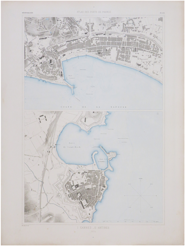
ATLAS des PORTS de FRANCE.
[CANNES & ANTIBES] I. Cannes. - II. Antibes.
1894. 593 x 382 mm.
Bookseller reference : LBW-6764
|
|
|
ATLAS des PORTS de FRANCE.
[CALAIS] Port de Calais.
1872. 565 x 358 mm.
Bookseller reference : LBW-6768

|
|
|
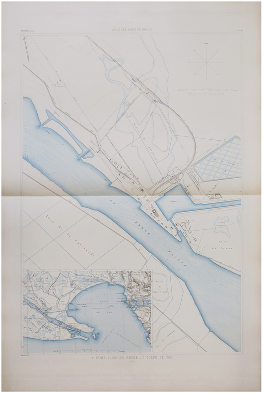
ATLAS des PORTS de FRANCE.
[CAMARGUE] I. Saint-Louis-du-Rhône. - II. Golfe de Fos.
1893. 840 x 560 mm.
Bookseller reference : LBW-6774
|
|
|
ATLAS des PORTS de FRANCE.
[CHERBOURG] Port de Cherbourg.
1878. 846 x 537 mm.
Bookseller reference : LBW-6679

|
|
|
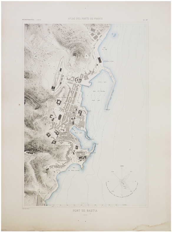
ATLAS des PORTS de FRANCE.
[CORSE/BASTIA] Port de Bastia.
1889. 555 x 358 mm.
Bookseller reference : LBW-6753
|
|
|
ATLAS des PORTS de FRANCE.
[CORSE/SAINT-FLORENT] I. Saint-Florent. - II. Centuri. - III. Tollari. - IV. Barcaggio. - V. Macinaggio. - VI. Luri. - VII. Porticciolo. - VIII. Erbalunga.
1888. 566 x 355 mm.
Bookseller reference : LBW-6756

|
|
|
ATLAS des PORTS de FRANCE.
[CORSE/AJACCIO] Port d'Ajaccio.
1889. 568 x 362 mm.
Bookseller reference : LBW-6757

|
|
|
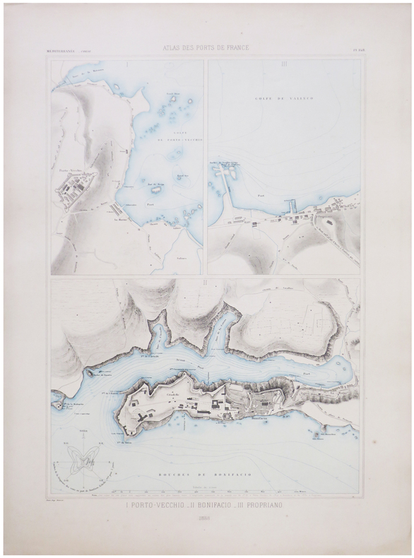
ATLAS des PORTS de FRANCE.
[CORSE/PORTO-VECCHIO] I. Porto-Vecchio. - II. Bonifacio. - III. Propriano.
1888. 568 x 380 mm.
Bookseller reference : LBW-6773
|
|
|
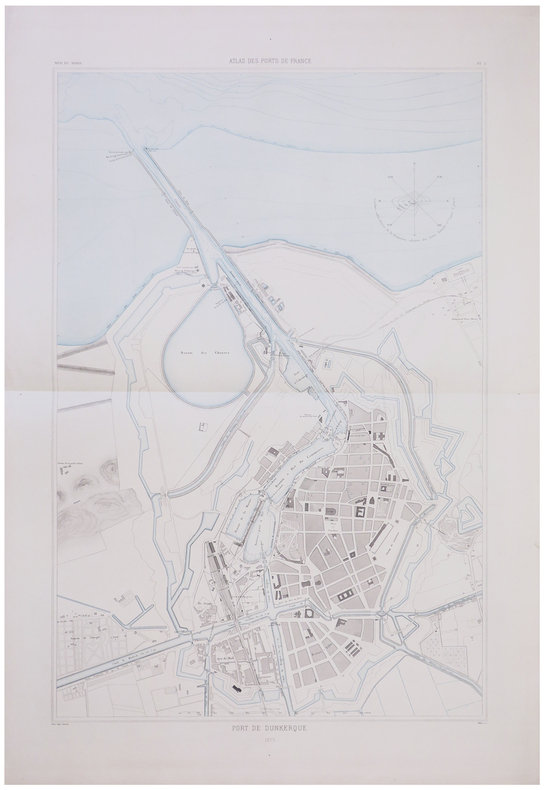
ATLAS des PORTS de FRANCE.
[DUNKERQUE] Port de Dunkerque.
1873. 843 x 530 mm.
Bookseller reference : LBW-6755
|
|
|
ATLAS des PORTS de FRANCE.
[FOURAS] Port de Fouras.
1882. 575 x 370 mm.
Bookseller reference : LBW-6770

|
|
|
ATLAS des PORTS de FRANCE.
[HONFLEUR] Port de Honfleur.
1875. 395 x 531 mm.
Bookseller reference : LBW-6778

|
|
|
ATLAS des PORTS de FRANCE.
[LA ROCHELLE] Port de La Rochelle.
1885. 857 x 547 mm.
Bookseller reference : LBW-6661

|
|
|
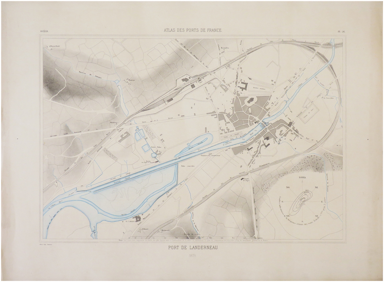
ATLAS des PORTS de FRANCE.
[LANDERNEAU] Port de Landerneau.
1879. 395 x 531 mm.
Bookseller reference : LBW-6780
|
|
|
ATLAS des PORTS de FRANCE.
[LE CROISIC] Port du Croisic.
1879. 572 x 365 mm.
Bookseller reference : LBW-6647

|
|
|
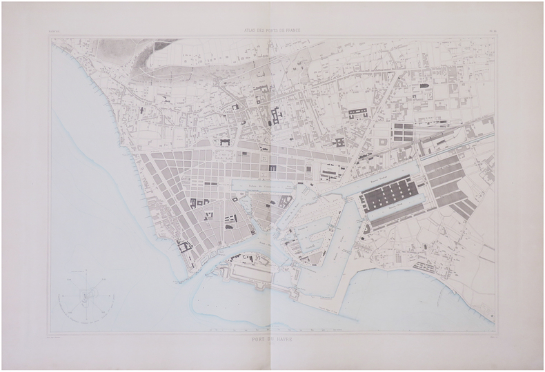
ATLAS des PORTS de FRANCE.
[LE HAVRE] Port du Havre.
1874. 563 x 807 mm.
Bookseller reference : LBW-6767
|
|
|
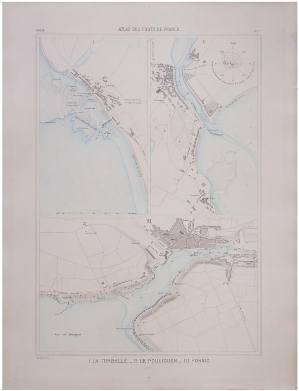
ATLAS des PORTS de FRANCE.
[LE POULIGUEN & PORNIC] I. La Turballe. - II. Le Pouliguen. - III. Pornic.
1879. 580 x 375 mm.
Bookseller reference : LBW-6772
|
|
 Receive by email
 Download as PDF document
 RSS feed


