|
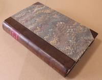
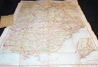
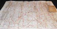
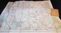
Foreign Office Historical Section Handbooks Nos. 134, 134A, 135, 136 & 137
Hardcover in good condition. No jacket. Ex-university library. Foreign Office Historical Handbooks 134 to 137 rebound in one volume. Includes fold-out maps. Boards and spine are marked and slightly faded. Spine head is bumped. Page block and a few pages are lightly marked and tanned. Labels on front pastedown. Stamps, light creases and nicks on a few pages. Text is clear throughout. HCW Used
|
|
|
Fotoalbum mit 29 (von 30) kleinformatigen Fotografien der Stadt Lyon.
Um 1890. Kl.-8°. Blindgepr. Lederband der Zeit. + Wichtig: Für unsere Kunden in der EU erfolgt der Versand alle 14 Tage verzollt ab Deutschland / Postbank-Konto in Deutschland vorhanden +, Abb.
Bookseller reference : 3242CB

|
|
|
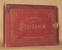
FOTOGRAFIER OFVER STOCKHOLM
Goteborg: Fran Axel Lindahls Atelier. Hardcover. Good. 12 albumen photographs of Stockholm and vicinity Circa 1880 in accordion-fold format. Condition of book is GOOD; Front & rear hinges are broken first panorama of Stockholm is torn as 1st part of it is on front paste-down otherwise condition of photographs is very good. Fran Axel Lindahls Atelier hardcover
Bookseller reference : 0000849
|
|
|
FOUR LARGE COLOUR MAPS OF RHUM: North West North East South West and South East. Scale 1:10000
Glasgow: Nature Conservancy/University of Glasgow 1972. Map. Very Good. Unframed. First Edition. 77 x 78 Cm. "Produced in the Department of Geography University of Glasgow on behalf of the Nature Conservancy. Printed by J. Bartholomew and Son Ltd. Edinburgh" Each map approximately 77 x 78 cm. These maps have been kept in a tube probably since published and have a little wear to edges and from being unrolled but are essentially in very good condition. Scarce. Nature Conservancy/University of Glasgow unknown
Bookseller reference : 034433
|
|
|
Fox's Festive Foods
Fox's Eastern District - reflecting New England and Southern specialties 4to size spiral bound pictorial softcover; 51 pages Table of Contents includes: Hors d'oeuvres and Spreads Main Dishes Vegetables and Side Dishes Stew Stuffing Sauce Soup Breads Desserts Holiday Drinks Recipes include: Bacon Cheese Rolls; Salmon Mousse; Tuna Pate; Beef a la Dustye; Barbecued Brisket of Beef; Creole Jambalaya; Shimp in Lobster Sauce; Sweet Potatoes; Fried Okra; Aunt Fanny's Baked Squash; Cauliflower or Broccoli Cheese Bake; Brunswick Stew; Southern Barbecue Sauce; Herb Italian Sausage Stuffing; Popovers; Original Bourbon Cake; Holiday Coffee Cake; Sour Cream Coffee Cake; Swedish Walnut Cake; Heath Bar Ice Cream Pie; Cream Cheese Pie; Apple Cake; Banana Cake more. Some light soil to covers there is a wavy area on blank back cover possibly water damage. . Spiral Comb. Good/No Jacket. 8vo - over 7¾" - 9¾" tall. Private Press. Paperback
Bookseller reference : 005152

|
|
|
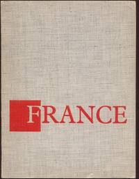
France
Paris: La Documentation Française 1962 WYSIWYG pricing--no added shipping charge for standard shipping within USA. Sewn in paper wraps printed with cloth pattern & orange titles 144 pp. Some rubbing to extremities previous owner's name rubber-stamped on title page. Official government publication promoting France this copy in English all text & the many b & w photos are printed by gravure. Shipping weight 1 lb. Wraps. Near Fine/No dj. 20½ X 15½ cm. La Documentation Française Paperback
Bookseller reference : TRFR00007
|
|
|
FRANCE - Prestige Enterprises - Muy ilustrado
París, Prestige Enterprises, s/f. Numerosas ilustraciones en color. 239p. 1h. 4º mayor. Rústica editorial ilustrada. Muy buen ejemplar. 1ª edición. Primera edición. 1st edition. First edition.
|
|
|
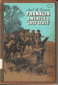
Franklin America's Lost State
New York: Cromwell-CollierPress 1968. Hardcover. Good/Good. 5.5" X 8.5. The internal politics of the US that thwarted the attempts for a state to be named Franklin North Carolina / Tennessee following independence. A former library book with the usual stamps and stickers and a protected dust wrapper. A clean and sound book. Available for prompt dispatch from the UK. <br/> <br/> Cromwell-CollierPress hardcover
Bookseller reference : 023480
|
|
|
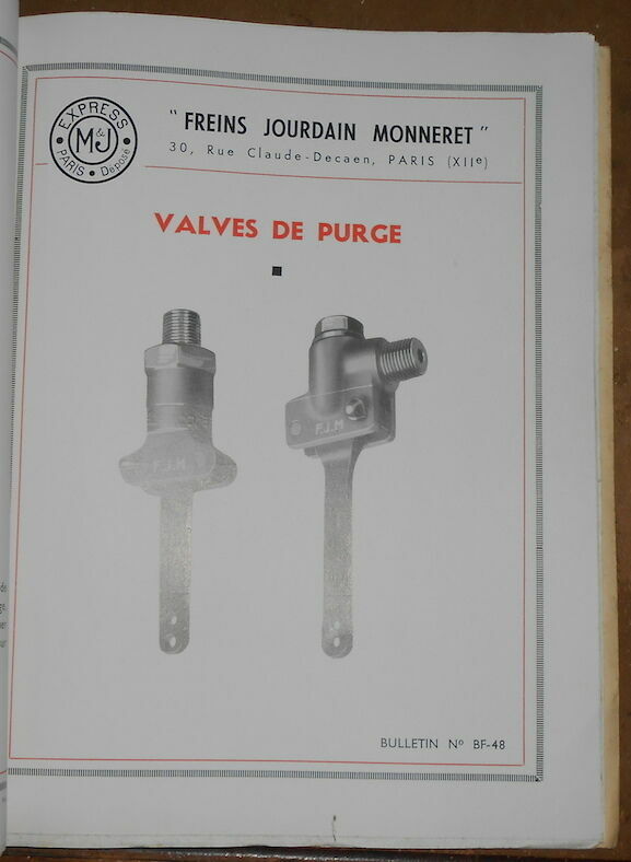
Freins Jourdain Monneret - Equipements de Frein et Servo-Commandes des Automotrices Renault type ABJ
Paris Société Jourdain Monneret s.d. (circa 1938) - Riveté 22 cm x 27 5 cm 19 pages + 22 bulletins rivetés à la suite de 2 à 8 pages 1 plan hors-texte nombreux et photographies in et hors-texte - Bon état
Bookseller reference : 17050
|
|
|
From the New Golden Land: Four Centuries of Travel and Exploration in the Americas. Selections from the Jay I. Kislak Foundation
New York: Grolier Club 1998. First Edition of 1000 copies . Wrappers. Very Good/No Jacket Paperback. 39 pp. 49 items described eight illustrations. Introduction by George E. Stuart. Spine 1" band across top edge of front cover and 1/2" band along rear spine edge faded otherwise Fine. Exhibition catalog. <br/> <br/> Grolier Club paperback
Bookseller reference : 10614
|
|
|
Frommer's Bermuda 2005. With the best beaches & golf resorts
Hoboken NJ: Wiley Publishing 2004. Soft cover. Good/No Jacket as published. 5.5" X 8.5. 241pp. A clean and sound guide book to this paradise island. A former library book with the usual stamps and stickers and a non-intrusive book jacket to protect the covers. Available for prompt dispatch from the UK. 5.5"x8.5". <br/> <br/> Wiley Publishing paperback
Bookseller reference : 022659 ISBN : 076457065X 9780764570650

|
|
|
Further Papers Relative to the Recent Discovery of Gold in Australia. In continuation of papers presented to Parliament 14 June 1852. Presented to both Houses of Parliament by command of Her Majesty February 28 1853. & with16th Augist 1873 .
Two Papers presented to both houses of Parliament by command of Her Majesty on Feb. 28th 1853 in continuation of 14th June 1852 & 16h Aug.1853 in continuation of Feb. 28th 1853. Both printed by Eyre & Spottiswoode for H.M.S.O. The first with large folding map a single page map and six full-page geological diagrams lithographed by Arrowsmith. The large folding map sheet size 708 x 560 mm by John Arrowsmith. The map is titled "The South Eastern Portion of Australia; Compiled from the Colonial Surveys and from Details Furnished from Exploratory Expeditions".The map was published on 2 January 1853 and has hand coloured details of the Australian goldfields based upon information supplied by Thomas Livingstone Mitchell. The second report dated 16th August 1853 contains a large folding panoramic outline of "the "General Appearance of the Country along the Upper Part of Maharatta Creek" and a single-page map of the Recently Opened Gold Field at Bingara in the District of Gwydir; with the Gold Field outlined in colour.Two volumes in one. Folio 13 1/2 x 8 3/4 inches pages: xvi:434:x:222. Recent half dark tan calf over marbled boards the spine crimson gilt lettered lettering piece. Excellent both internally and externally. Two Papers presented to both houses of Parliament by command of Her Majesty on Feb. 28th, 1853 [ in continuation of 14th June 18 hardcover
Bookseller reference : 22490
|
|
|
Future Map 01
London: the London Institute 2001. The cover has large folded flaps and minimal general wear. K. First Edition. paperback. Very Good/No Dust Jacket. Used. the London Institute Paperback
Bookseller reference : 235705 ISBN : 1870540239 9781870540230

|
|
|
Fédération des Vosges des syndicats d’initiative. Climatisme - Thermalisme - Tourisme. Bas-Rhin - Haut-Rhin - Meurthe-et-Moselle - Moselle - Vosges. 7e Edition.
Strasbourg, Fédération des Vosges des syndicats d’initiative 1927, 220x135mm, 86pages, broché. Déchirures sur le haut du dos et sur les coins de la couverture supérieure, autrement bon état.
Bookseller reference : 73413

|
|
|
GALICIA, ASTURIAS - Madrid 2004 - Ilustrado
Madrid, Edit. Rueda, 2004. Colección Nuestros Pueblos. Numerosas ilustraciones en color. 198 p. 4º. Cartoné editorial ilustrada. Muy buen ejemplar.
|
|
|
GARES FERROVIAIRES: René CLOZIER: La gare du Nord, Baillière, 1940. La nouvelle gare de Paris-Est, Le Batiment illustré, 1931. LA GARE DE L'EST, Compagnie des Chemins de Fer de l'Est, 1931. La gare, Bibliothèque de travail, 1950. Laurent BAUDOIN: Les gares d'Alsace Lorraine, Editions Pierron, 1995. André SCHONTZ: Le chemin de fer et la gare de Metz, Editions Serpenoise, 1990. Gares 1994 La nouvelle génération, SNCF, Mai 1994. Paul GENELOT: La gare de Montpellier à travers le temps, Editions EspaceSud, 1993. Christian SCELLES: Gares Ateliers du voyage 1837-1937, R.E.M.P.A.R.T., Desclée de Brouwer, 1993. Le Train Bleu THE TRAIN BLEU Paris, P.L.U.S. Editions.
Ensemble de 10 ouvrages.
Bookseller reference : N137

|
|
|
GARRAF - Granollers c. 1949
Granollers, Edit. Alpina, s/f. Mapa topográfico excursionista. Escala 1: 25.000. Entelado. Cerrado con funda de tela con cinta. Firma antiguo propietario. Muy buen ejemplar.
|
|
|
GARRAF - Granollers c. 1949 - Mapa
Granollers, Edit. Alpina, s/f. Mapa topográfico excursionista. Escala 1: 25.000. Entelado. Cerrado on funda de tela con cinta. Firma antiguo propietario. Muy buen ejemplar.
|
|
|
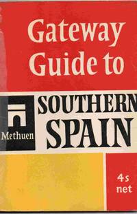
Gateway Guide to Southern Spain
London: Methuen 1965. Soft cover. Good. 4.5" x 6.5. 64 pages. A pocket travel guide to southern Spain Some reading wear but still a tidy copy. Previous owner's signature at the head of the first page. All orders processed promptly and shipped from the UK. <br/> <br/> Methuen paperback
Bookseller reference : 027870
|
|
|
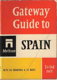
Gateway Guide to Spain
London : Methuen 1958. Soft cover. Good/No Jacket as published. 4.5" x 6.5. A guide to Spain for the tourist including 18 tours. Some reading wear and the front cover has been folded at some stage. Stilla tidy copy available for prompt dispatch from the UK <br/> <br/> Methuen paperback
Bookseller reference : 023944
|
|
|
GATEWAY TO GERMANY - Bonn 1953 - Muy ilustrado
Bonn, Édit. für Publizistik GMBH, 1953. Numerosas fotografías y dibujos en b/n. s/p. 8º mayor. Rústica editorial ilustrada, levemente deslucida. Book in English. Buen ejemplar.
|
|
|
GATEWAY TO GERMANY - Bonn 1954 - Muy ilustrado
Bonn, Édit. für Publizistik GMBH, 1954. Numerosas fotografías y dibujos en b/n. 72 p. 8º mayor. Rústica editorial ilustrada. Book in English. Muy buen ejemplar.
|
|
|
Gent Belgium
28 pages, illustrated, English, German, Flemish and French text. eng
|
|
|
Geo Special Hamburg. Hrsg. v. Henri Nannen.
Hamburg Gruner & Jahr 1983. . (Hamburg, Gruner & Jahr, 1983). unknown
Bookseller reference : 14176

|
|
|
GEOGRAFIA UNIVERSAL (5 vol. - Completo) - Barcelona 1963-1965 - Ilustrado
Barcelona, Edit. Instituto Gallach, 1963-65. Numerosas ilustraciones y mapas en b/n. 487 p. 4º. Tela editorial algo deslucida con dorados en la cubierta y el lomo. Buen ejemplar. Enciclopedia de geografía universal en cinco volúmenes: la Tierra, regiones polares, Europa, Asia, América, África y Oceanía.
|
|
|
GEOGRAFÍA - ATLAS. Primer Grado - Barcelona 1927 - Muy ilustrado
Barcelona, Edi. Coello, 1927. Numerosas ilustraciones en b/n. Mapas coloreados. 88 p. 8º mayor apaisado. Holandesa. Guardas coloreadas. Ex libris. Muy buen ejemplar.
|
|
|
GEOGRAFÍA UNIVERSAL (3 vol. - Completo) - Barcelona 1959
Barcelona, Edit. Planeta, 1959. Numerosas ilustraciones en color y b/n. Unas 400 p. por tomo. 4º. Cartoné editorial con sobrecubierta ilustrada algo deslucida. Buen ejemplar.
|
|
|
GEOGRAFÍA UNIVERSAL (5 vol. - Completo) - Barcelona 1963-1965 - Ilustrado
Barcelona, Edit. Instituto Gallach, 1963-65. Numerosas ilustraciones y mapas en b/n. 487 p. 4º. Tela editorial algo deslucida con dorados en la cubierta y el lomo. Buen ejemplar. Enciclopedia de geografía universal en cinco volúmenes: la Tierra, regiones polares, Europa, Asia, América, África y Oceanía.
|
|
|
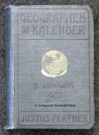
Geographen-Kalender. JG. 5. In Verbindung mit vielen Fachgenossen hrsg. von Hermann Haack.
Gotha Justus Perthes 1907. . Kap. beschabt StaT. - Enthält u.a. eine Biographie des italienischen Geographen Giuseppe Dalla Vedova 1834-1919 ital./dt. eine "geographische Chronik" 1906 sowie Verzeichnisse geographischer Forschungsreisen u. geographischer Literatur 1906. - Der Geograph Hermann Haack 1872-1966 seit 1897 Mitarbeiter der Geographischen Anstalt Justus Perthes war u.a. maßgeblich beteiligt an der Entwicklung von Schulwandkarten. Gotha, Justus Perthes, 1907. unknown
Bookseller reference : 49558
|
|
|
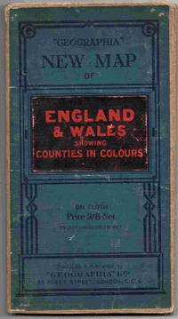
Geographia New Map of England & Wales showing Counties in Colour. Scale 4 miles to the inch.
London: Geographia Ltd . Soft cover. Fair/No Jacket as published. 5" x 8. A map of England Wales on cloth. Not dated but believed to be circa 1920. Shows some signs of handling / use. Some neat annotations to highlight railways. All orders processed and shipped promptly from the UK. Please email with your questions. <br/> <br/> Geographia Ltd paperback
Bookseller reference : 025641
|
|
|
Geographisch-statistisches Comtoir- und Zeitungs-Lexikon. Nach den neuesten Bestimmungen. Oder Beschreibung der Länder, Meere, Seen, Flüsse, Inseln (...) in Hinsicht der Lage, Grösse, Produkte, Merkwürdigkeiten (...) In alphabetischer Ordnung. Für Geschäftsmänner, öffentliche Bureaus, Comtoirs, Kaufleute (...).
Reutlingen, J. J. Mäcken, 1830. 8°. IV S., S.5-779. Goldgepr. Lederband mit goldgepr. Wappensuplalibros u. 3-s. Goldschnitt + Wichtig: Für unsere Kunden in der EU erfolgt der Versand alle 14 Tage verzollt ab Deutschland / Postbank-Konto in Deutschland vorhanden +, 28913A (bestossen, vord. Gelenk restauriert).
Bookseller reference : 28913AB

|
|
|
Geographisch-statistisches Comtoir- und Zeitungs-Lexikon. Nach den neuesten Bestimmungen. Oder Beschreibung der Länder, Meere, Seen, Flüsse, Inseln (...) in Hinsicht der Lage, Grösse, Produkte, Merkwürdigkeiten (...) In alphabetischer Ordnung. Für Geschäftsmänner, öffentliche Bureaus, Comtoirs, Kaufleute (...).
Reutlingen, J. J. Mäcken, 1830. 8°. IV S., S.5-779. Goldgepr. Lederband mit goldgepr. Wappensuplalibros u. 3-s. Goldschnitt (bestossen, vord. Gelenk restauriert).
Bookseller reference : 28913AB

|
|
|
Giornale di notizie spettanti il viaggio per la Francia del sommo pontefice Pio Settimo - Allocuzione dalla santità di nostro signore Pio Settimo fatta nel concistoro segreto il 26 giugno 1805 - Sanctissimi domini nostri Pii divina providentia Papae VII allocutio habita in consistorio secreto XXIX octobris 1804
In-4°; pp. 135, (1), 15, (1), su carta azzurrina, stemma pontificio al front.; pp. VIII. Legatura coeva in mezza pelle con angoli e fregi in oro al dorso, tagli marmorizzati. Estesa annotazione manoscritta “Memoria scritta l’anno 1814” sul primo foglio di guardia, prosegue al verso del front. di “Sanctissimi domini nostri Pii...”, con trasferimento di inchiostro al recto, e all’ultimo foglio di guardia. Interessante fonte per la storia della cerimonia dell’Incoronazione di Napoleone Imperatore, avvenuta a Notre Dame il 2 dicembre, e della festa che ne seguì. E anche resoconto del viaggio con cui il pontefice Pio VII (1800-23) si recò in Francia; vengono accuratamente descritti i dettagli della partenza, gli approvvigionamenti, il clero al seguito. L’itinerario, suddiviso in Fogli, si snoda da Roma a Modena, Milano, fino a Parigi e rientro passando per Firenze, Perugia, Foligno.
|
|
|
GIPUZKOA. Mapa - Donosti 1979 - Ilustrado
Donostia, Edit. Caja Aho. Municial San Sebastian, 1979. Gran mapa desplegable de Guipuzcoa. Folio. Plegado y guardado en una carpeta en rústica ilustrada. Muy buen ejemplar.
|
|
|
Glasers Annalen. Zeitschrift fur Eisenbahnwesen und Verkehrstechnik - 27. April - 6. Mai 1958
Georg Siemens 1958. Book. Very Good. Soft cover. 1st Edition. Georg Siemens 1958. Very good softcover. . Georg Siemens Paperback
Bookseller reference : 016969
|
|
|
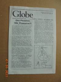
Globe - Newsletter of the Globetrotters Club London Vol.32 No.4 July/August 1984
Globetrotters Club London 1984. Pamphlet. Very Good. Single horizontal crease and other faint random crease marks from being circulated in the mail. 21 x 297 cm. 12 pages. Clean unmarked no tears or stains. <br/> <br/> Globetrotters Club (London) unknown
Bookseller reference : 021934
|
|
|
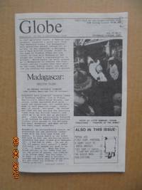
Globe - Newsletter of the Globetrotters Club London Vol.37 No.5 September/October 1989
Globetrotters Club London 1989. Pamphlet. Good. Staple mark to top foredge corner one article 4 pages on motorbiking in Portugal has underlining otherwise clean and in excellent state. 145 x 21 cm. 24 pages. <br/> <br/> Globetrotters Club (London) unknown
Bookseller reference : 021937
|
|
|
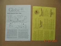
Globe - Newsletter of the Globetrotters Club London Vol.30 No.5 September/October 1982
Globetrotters Club London 1982. Pamphlet. Good. Single horizontal crease and other random crease marks from being circulated in the mail. A few pen marks in page margins on four pages. 21 x 297 cm. 12 pages. Includes in separata membership application trifold with 3 panels and one page. <br/> <br/> Globetrotters Club (London) unknown
Bookseller reference : 021933
|
|
|
Gobernacion De Antioquia: Departamento Administrativo De Planeacion Direccion De Desarrollo: Region Sur
Medellin: Imprenta Deptal De Antioquia. 1981. Book. Very Good. Soft cover. 4to - over 9¾" - 12" tall. Softcover 1981 edition. Ex-library book with stamps and labels attached. Binding firm. Pages unmarked and clean. Covers and text in very good condition. 241 pages. Imprenta Deptal De Antioquia. Paperback
Bookseller reference : 004875
|
|
|
Gouffre de Padirac Riviere Souterraine: Historique et Visite Guidee
Editions As de Coeur 1989. Couverture souple. Comme neuf. Color photos; staplebound; visitor's guide sold exclusively on site. <br/> <br/> Editions As de Coeur unknown
Bookseller reference : 000069

|
|
|
GRAN ATLAS UNIVERSAL Y DE ESPAÑA - Carroggio 1998 - Muy ilustrado
Barcelona, Carroggio, 1998. Numerosas fotografías e ilustraciones a color en el texto. 352 p. Folio mayor. Símil piel editorial. Muy buen ejemplar.
|
|
|
Grand Duchy of Luxembourg Tourist Guide
96 pages, maps of cantons, 215 colour photos. eng
|
|
|
Grande Carte Routiere No. 17: Midi de la France: Section Est Htes et Bses Alpes Provence Cote d'Azur
Paris: A. Taride Editeur 1915. Map. Very Good -. 1 folded map 95 x 75 cm. in an envelope 19 x 13 cm. "Carte Routière pour Automobilistes & Cyclists -- Sud de la France Section Est" -- at upper edge of map. "Cartes Taride" -- at upper edge of envelope. Map in color showing roads paths canals and railroads. Back of envelope has map of France showing the 34 areas covered by the "Nouvelle Carte de France a l'usage des Cyclistes et Automobilistes." No date of publication. This series of maps was issued from 1904 to 1925. Front of envelope lists recommended hotels and garages. Map is in Very Good- Condition: starting to separate at folds; clean and complete. Envelope is in Good Condition: edges are rubbed; starting to separate along one edge. A. Taride Editeur unknown
Bookseller reference : 005831
|
|
|
Grande Carte Routiere No. 12: Centre de la France Section Ouest: Berry -- Poitou -- Touraine
Paris: A. Taride Editeur 1915. Map. Very Good -. 1 folded map 70 x 100 cm. in an envelope 19 x 13 cm. "Carte Routière pour Automobilistes & Cyclists -- Centre de la France Auvergne" -- at upper edge of map. "Cartes Taride" -- at upper edge of envelope. Map in color showing roads paths canals and railroads. Back of envelope has map of France showing the 34 areas covered by the "Nouvelle Carte de France a l'usage des Cyclistes et Automobilistes." No date of publication. This series of maps was issued from 1904 to 1925. Front of envelope lists recommended hotels and garages. Map is in Very Good- Condition: starting to separate at folds; clean and complete. Envelope is in Good Condition: closed tears at edges; otherwise intact and clean. A. Taride Editeur unknown
Bookseller reference : 005828
|
|
|
Grande Carte Routiere No. 7: Environs de Paris Section Sud Est
Paris: A. Taride Editeur 1915. Map. Fine. 1 folded map 72 x 91 cm. in an envelope 19 x 13 cm. "Carte Routière pour Automobilistes & Cyclists" -- at upper edge of map. "Cartes Taride" -- at upper edge of envelope. Map in color showing roads paths canals and railroads. Back of envelope has map of France showing the 34 areas covered by the "Nouvelle Carte de France a l'usage des Cyclistes et Automobilistes." No date of publication. This series of maps was issued from 1904 to 1925. Front of envelope lists recommended hotels and garages. Map is in Fine Condition: clean and crisp. Envelope is in Very Good Condition: corners are rubbed; lightly creased; intact and clean. A. Taride Editeur unknown
Bookseller reference : 005826
|
|
|
Grande Carte Routiere No. 15: Centre de la France: Section Sud-Est Auvergne et Limousin
Paris: A. Taride Editeur 1915. Map. Very Good -. 1 folded map 72 x 93 cm. in an envelope 19 x 13 cm. "Carte Routière pour Automobilistes & Cyclists -- Centre de la France: Section Sudest" -- at upper edge of map. "Cartes Taride" -- at upper edge of envelope. Map in color showing roads paths canals and railroads. Back of envelope has map of France showing the 34 areas covered by the "Nouvelle Carte de France a l'usage des Cyclistes et Automobilistes." No date of publication. This series of maps was issued from 1904 to 1925. Front of envelope lists recommended hotels and garages. Map is in Very Good- Condition: starting to separate at folds; clean and complete. Envelope is in Good Condition: edges are rubbed; closed tear at lower edge; partially separated along one glued edge; clean. A. Taride Editeur unknown
Bookseller reference : 005830

|
|
|
Grande Carte Routiere No. 14 bis: Des Alpes: Savoie et Haute Savoie
Paris: A. Taride Editeur 1915. Map. Very Good -. 1 folded map 75 x 53 cm. in an envelope 19 x 13 cm. "Carte Routière pour Automobilistes & Cyclists -- Frontiere des Alpes" -- at upper edge of map. "Cartes Taride" -- at upper edge of envelope. Map in color showing roads paths canals and railroads. Back of envelope has map of France showing the 34 areas covered by the "Nouvelle Carte de France a l'usage des Cyclistes et Automobilistes." No date of publication. This series of maps was issued from 1904 to 1925; this map has a note about a road that opened to automobiles in June 1912. Front of envelope lists recommended hotels and garages. Printed label with "Prix: 3 fr. net" covering earlier price on front of envelope. Map is in Very Good- Condition: light soiling in margins; pencilled notations in lower margins; bright and intact. Envelope is in Very Good- Condition: edges are rubbed; intact and clean. A. Taride Editeur unknown
Bookseller reference : 005829

|
|
|
Grande Carte Routiere No. 32: Italie Méridionale et Sicile
Paris: A. Taride Editeur 1910. Map. Fine. 1 folded map 94 x 75 cm. in an envelope 19 x 13 cm. "Cartes Taride" -- at upper edge of envelope. Map in color showing roads paths canals and railroads with captions in French and Italian. Back of envelope has map of France and adjacent territory showing the 34 areas covered by the "Nouvelle Carte de France a l'usage des Cyclistes et Automobilistes." No date of publication. This series of maps was issued from 1904 to 1925. Printed label with "Prix: 2 fr. net" covering earlier price on front of envelope. Map is in Fine Condition: clean and bright; fully intact. Envelope is in Good Condition: both the glued side and lower edge have opened; lightly soiled. A. Taride Editeur unknown
Bookseller reference : 005833

|
|
|
Grande Carte Routiere No. 30: Italie: Section Nord
Paris: A. Taride Editeur 1915. Map. Good -. 1 folded map 66 x 90 cm. in an envelope 19 x 13 cm. "Cartes Taride" -- at upper edge of envelope. Map in color showing roads paths canals and railroads with captions in French and Italian. Back of envelope has map of France and adjacent territory showing the 34 areas covered by the "Nouvelle Carte de France a l'usage des Cyclistes et Automobilistes." No date of publication. This series of maps was issued from 1904 to 1925. Printed label with "Prix: 3 fr. net" covering earlier price on front of envelope. Map is in Good- Condition: separating at folds; upper and lower halves are completely separated; minimal archival repairs on back along some folds; pencilled notations in lower margins. Envelope is in Good- Condition: open along one side; starting along other edges. A. Taride Editeur unknown
Bookseller reference : 005832

|
|
|
Grande Carte Routiere No. 8: Environs de Paris Section Sud Ouest
Paris: A. Taride Editeur 1915. Map. Fine. 1 folded map 72 x 91 cm. in an envelope 19 x 13 cm. "Carte Routière pour Automobilistes & Cyclists" -- at upper edge of map. "Cartes Taride" -- on front of envelope. Map in color showing roads paths canals and railroads. Back of envelope has map of France showing the 34 areas covered by the "Nouvelle Carte de France a l'usage des Cyclistes et Automobilistes." No date of publication. This series of maps was issued from 1904 to 1925. Front of envelope lists recommended hotels and garages. Map is in Fine Condition: clean and crisp. Envelope is in Very Good- Condition: corners are rubbed; closed tear at lower edge; lightly creased; intact and clean. A. Taride Editeur unknown
Bookseller reference : 005827

|
|
 Receive by email
 Download as PDF document
 RSS feed


