1616 resultados
ref. 1841395730.Gmap. Good. Access codes and supplements are not guaranteed with used items. May be an ex-library book. unknown
ref. 4465710Philips. 01. Spiral-bound. Used; Very Good. Simply Brit welcome to our online used book store where affordability meets great quality. Dive into a world of captivating reads without breaking the bank. We take pride in offering a wide selection of used books from classics to hidden gems ensuring theres something for every literary palate. All orders are shipped within 24 hours and our lightning fast-delivery within 48 hours coupled with our prompt customer service ensures a smooth journey from ordering to delivery. Discover the joy of reading with us your trusted source for affordable books that do not compromise on quality. 04/05/2018 Philips unknown
1934ref. 2083002116201764Oriental Maps Yoshimitsu Nonaka. Kiyoshi Tsukamoto 1934. Soft Cover. Fine. The book is in fine condition. Oriental Maps Yoshimitsu Nonaka. Kiyoshi Tsukamoto paperback
ref. 092959195X.Gpaperback. Good. Access codes and supplements are not guaranteed with used items. May be an ex-library book. paperback
ref. 366634US: Houghton Mifflin 1952. Houghton Mifflin 1952 First Edition NAP Fine/Very Good DJ Author: De Voto Bernard; Raisz Erwin maps. Light blue cloth with grey text bloacks and brown lettering. USA map end papers. Pages lightly tanned with many smaller maps in text. xxii647 pages with index. Bright glossy clipped dust jacket with small mended tears protected in clear dust jacket cover. HEAVY ITEM 1.89 Pounds. Size: 8 5/8 x 6 x 1 1/2 inches. First Edition NAP. Hardcover. Fine/Very Good DJ. No Exp. Houghton Mifflin Hardcover
1956ref. pl199-94Dryden Press 1956. Hardcover. Used - Very Good. Year: 1956. Publisher: Dryden Press. This preowned item is in very good condition with very minimal wear and tear visible ex. Corner dings small tears/rips bent pages scuffs/scratches etc. Additional materials such as CD's and access codes may or may not be included. If the book has a dust jacket it may not be included. Free tracking provided. International shipping available. Dryden Press hardcover
ref. 0935039996.Gmap. Good. Access codes and supplements are not guaranteed with used items. May be an ex-library book. unknown
ref. 3844349561.Gpaperback. Good. Access codes and supplements are not guaranteed with used items. May be an ex-library book. paperback
ref. 0540087726.Gpaperback. Good. Access codes and supplements are not guaranteed with used items. May be an ex-library book. paperback
ref. 0008370001.Gpaperback. Good. Access codes and supplements are not guaranteed with used items. May be an ex-library book. paperback
ref. GOR002367632Paperback. Very Good. paperback
2012ref. 1-0792294580National Geographic 2012. Map. New. map edition. 1 pages. 38.50x5.00x4.00 inches. National Geographic unknown
2001ref. 104559Irvine CA: Thomas Bros. Maps 2001. 2001 Ed. Spiral-bound. Near fine; some creasing to wraps near spine; top corner a tad warped toward back of book; else clean and bright; still very useful and readable. Small folio metal spiral bound atlas; various pagings: color maps ; 29 cm; includes indexes and mileage chart. Looking for a more analog big-picture way to travel Look no further than the trusty Thomas Guide seat pocket companion of yore that will either pluck at nostalgic heartstrings or delight curious digital natives. Features: over 257000 square miles covered 79 pages of detail city maps digital cartography for greater accuracy and detail large print and scale for easier reading information on scenic highways distances and mileages and statewide shaded relief maps. Cartographic Mathematical Data: Scales differ. Relief shown by hachures and spot heights on some maps. Includes indexes and mileage chart. // California Maps Roads Roads California Maps. Thomas Bros. Maps unknown
ref. 0964540401.Gpaperback. Good. Access codes and supplements are not guaranteed with used items. May be an ex-library book. paperback
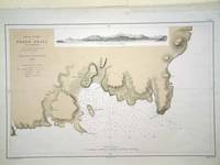
ref. 6279Paris: 1868. No binding. Very Good. 305 x 470 mm. in very good condition. A fine large scale plan of the harbour of 'Porto Praya' Praia on Santiago the capital of the Cape Verde Islands. It is situated on the south coast and shows wonderfully how the town has grown; the whole area to the south and west of the town is now developed. A prospect of the approach is shown above. The roads and individual buildings are shown as are numerous soundings in the Bay. The original survey in 1834 is the work of Lieutenant William Arlett of the British Royal Navy who is duly credited in the title. 1868 unknown
ref. 1931257361.Gmap. Good. Access codes and supplements are not guaranteed with used items. May be an ex-library book. unknown
ref. 0008328072.Gmap. Good. Access codes and supplements are not guaranteed with used items. May be an ex-library book. unknown
1982ref. Q-093528432XThe Patrice Press 1982. paperback. New. In shrink wrap. Looks like an interesting title! The Patrice Press paperback
ref. Q-0316706078Little Brown & Company 1929-01-01. Hardcover. New. In shrink wrap. Looks like an interesting title! Little Brown & Company hardcover
ref. 1841392723.Gmap. Good. Access codes and supplements are not guaranteed with used items. May be an ex-library book. unknown
ref. 0881306894.Gpaperback. Good. Access codes and supplements are not guaranteed with used items. May be an ex-library book. paperback
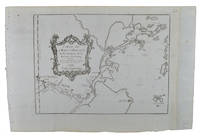
1749ref. 136827Paris. Circa1749. Engraved map on watermarked laid paper 20 x 27.3 cm of Fuzhou and coastline of Fujian Province original folds designed by the great French cartographer Jacques-Nicolas Bellin. This map is from the impressive 15-volume "Histoire Génèrale des Voyages" compiled by Antoine François Prévost map no. 2 Vol. 6. This map shows the estuary of Yangtze River Rivière de Chang. Very light browning on sheet edges but in very good condition. . unknown
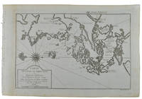
1749ref. 136826Paris. circa1749. Black and white engraved map on watermarked laid paper 20.9 x 32.7cm showing coastal area of Zhejiang Province Province de Che-kiang including Zhoushan Archipelago Isle de Chusan Zhoushan Bay Bay de Chusan and Xiangshan County Siang-chan-luen a walled city outside of upper border Ningbo Ning-po prefecture under Qing administration title cartouche lower left original folds. This map is No. 3 Vol. 6 from the impressive 15-volume "Histoire Generale des Voyages" compiled by Antoine François Prévost. Even browning mainly to the sheet edges in very good condition. . unknown
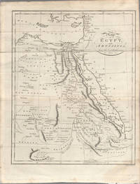
1803ref. 174955London. circa1803. Engraved map 23 x 18.5 cm original folds small split to one fold affecting the margin only paper age- toned lower corner darkened and on the verso inked circles to the lower half in an early hand but in good condition. Finely engraved early 19th Century map also showing to the north Syria Palestine and Cyprus and Darfur and Mountains of the Moon Sources of the Nile to the South. . unknown
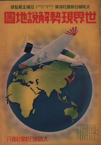
1937ref. 208633大阪朝日新聞社. Osaka Asahi Shinbunsha. Showa 12 1937. 10 colour maps not including insets or sketch maps in text on 12 pages. Handsome world map features as the centre fold colour pictorial paper wrappers. A little light soiling and horizontal crease wrappers. An attractive atlas. 38 x 26.7cm. A large format atlas with six pages of coloured maps showing the nations of the world and five pages of Japanese text. The publication seems to have been produced to celebrate the 1937 world record flight from Tokyo to London by Iinuma Masaaki and Tsugayoshi Kenji in their plane 'Kamikaze' which was sponsored by the Asahi Newspaper. The front cover depicts the plane soaring over a map of the world while the back cover also had a colour image of the 'Kamikaze' with an advertisement for the Oji Paper Company which we are told donated a hundred million yen to support the flight. The name 'Kamikaze" had at that stage not yet taken on the connotations which it acquired during the Pacific War. The maps inside the volume show political boundaries major cities and transport routes. The opening pages show the Japanese Empire including Japan proper Korea Karufuto and Manchukuo with small insets covering Taiwan the Chishima Archipelago and Japan's South Sea mandate. The accompanying text focuses on Japan's newly acquired client state of Manchukuo detailing its area population principle products etc while the map includes graphs illustrating Japan's trade with the world and with Manchukuo. China receives an entry of its own with a map of the Chinese Republic and information on the political situation population trade and infrastructure. The central pages of the volume are taken up with a double-spread map of the world including depictions of the flags of a selection of the world's nations. Other sections of the work cover Asia Europe America Africa and Oceania grouped together. The discussion of Oceania includes a section on Hawaii and some small and improbable depictions of Maori and Indigenous Australians. . 大阪朝日新聞社. [Osaka Asahi Shinbunsha]. unknown