|
HOMANN Johann Baptist
Accurate Vorstellung der Orientalisch- Kayserlichen Haupt- und Residenz-Stadt Constantinopel - Carte de Constantinople
s.d. (circa 1720), 62x53,5cm, une feuille rempliée.
Bookseller reference : 69030
|
|
|
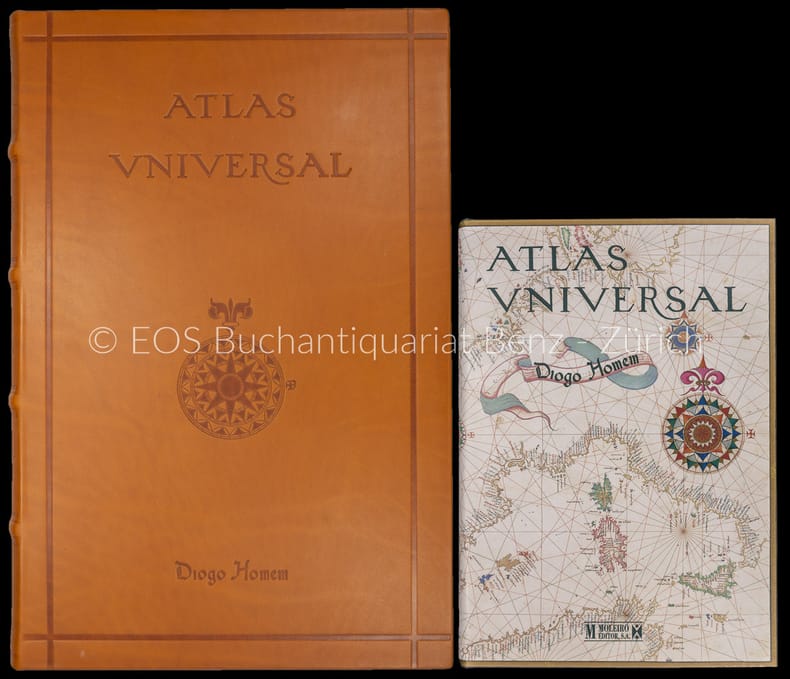
Homem, Diogo:
Atlas universal. – (Faks. der Ausg. der russischen Nationalbibliothek Sankt Petersburg von 1565).
2 Bände. Barcelona, Moleiro, 2000–2002. Folio und quart. 331 S. Mit (20) Bl. mit faks. Karten. Leinen- und Lederband in Lederbox.
Bookseller reference : 30664AB
|
|
|
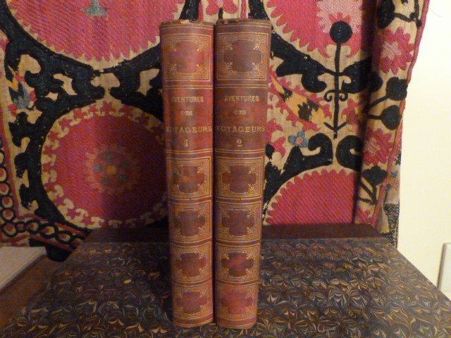
Hombron, Jacques Bernard.
Aventures les plus curieuses des voyageurs, coup d'oeil autour du monde d'après les relations anciennes et modernes et des documents recueillis sur les lieux.
Paris, Belin-Leprieur et Morizot, 1847. 2 volumes in-8, plein percaline, dos lisse orné de filets et de motifs floraux dorés, plats supérieur orné de motifs floraux dorés et noirs, plats inférieurs ornés en noir, titres dorés, toutes tranches dorées, tome I: III, 496 pp; tome II: 476 pp. Nombreuses illustrations hors texte en noir. Dos défraîchis et gondolés, manques sur les coiffes supérieures, petites tâches sur les plats, charnières inférieures et intérieures des 2 volumes fragiles, rousseurs.
Bookseller reference : DEZ-972
|
|
|
Hombron, Jacques Bernard.
Aventures les plus curieuses des voyageurs, coup d'oeil autour du monde d'après les relations anciennes et modernes et des documents recueillis sur les lieux.
1847 Paris, Belin-Leprieur et Morizot, 1847. 2 volumes in-8,, reliures demi chagrin rouge de l'époque, , dos ornés de filetss dotés et décors estampés a froid, , tome I: III, 496 pp; tome II: 476 pp, .6 illustrations hors texte , illustrations in texte,
Bookseller reference : 11978
|
|
|
HOMBRON (Jacques Bernard)
Aventures les plus curieuses des voyageurs. **. Coup d'oeil autour du monde d'après les relations anciennes et modernes et des documents recueillis sur les lieux. Ouvrage imité des Aventures des Voyageurs par P. BLANCHARD.
Paris BELIN-LEPRIEUR et MORIZOT, sans date (vers 1860) 0 un volume in-8°, [2] ff. 468 pp. Reliure éditeur en percaline noire chagrinée, premier plat à la plaque dorée et polychrome encadrée de filets estampés à froid, dos lisse orné de fers dorés et polychromes, tranches dorées, gardes de papier jaune. (dos frotté avec de petites pertes de percaline, petites coupures aux coiffes, percaline ouverte sur 10 cm près du plat supérieur, coins légèrement frottés, présence de rousseurs pâles cantonnées pour la plupart dans les marges, hors-texte faiblement brunis). Charmant ouvrage de voyages illustré de 26 gravures hors-texte dont un frontispice et 3 planches en couleurs. TOME II SEUL. COOK - BONTIKOE - BOUGAINVILLE - WILSON - LA PEROUSE - DUMONT D'URVILLE. L'auteur fut l'un des compagnons de l'Amiral DUMONT d'URVILLE pendant son voyage au Pôle Sud et dans l'Océanie.
Bookseller reference : 023492
|
|
|
HOMBRON (M.).
Aventures les plus curieuses des voyageurs. Coup d'oeil autour du monde.
Paris Belin-Leprieur et Morizot 1847 1 vol. relié in--8, demi-chagrin vert, dos à nerfs, III + 496 pp., 21 gravures hors-texte dont un frontispice et 3 planches en couleurs. Ouvrage imité des "Aventures des voyageurs", par P. Blanchard où sont évoqués : Christophe Colomb, Pizarre, Cortez, Mungo-Park, Lemaire, Caillé, Le vaillant, Ross, etc. Mouillure marginale sans atteinte au texte sur centaine de pages et petites rousseurs éparses. Bonne reliure d'époque. TOME I SEUL (Spitzberg, Nouvelle-Zemble, Pic Ténériffe, Canaries, Cap vert, Afrique Sénégambie, Cap de Bonne Espérance, Amérique du sud Christophe Colomb, Cortez, Pizarre).
Bookseller reference : 98754
|
|
|
HOMBRON, (JACQUES BERNARD).
Aventures les plus curieuses des Voyageurs Coup D'oeil autour du Monde d'apres les Relations anciennes et modernes et de Documents recueillis sur les lieux. Ouvrage imité des Aventures des Voyageurs par P. Blanchard. 2 vols.
Paris, Belin-Leprieur et Morizot, 1847. Bound in 2 profusely gilt and ornamented in different colours, original full cloth. Binding of vol. 1 rubbed and tears in hinges. Corners bumped, spine ends worn. All edges gilt. Occasionally brownspotted. Stamp on title. 2 frontispieces. (1),III,496(1),476 pp. 38 fine wood-engraved plates and many textillustr.
Bookseller reference : 25664
|
|
|
HOMBRON M
Aventures les plus curieuses des voyageurs. Coup d'oeil autour du monde d'après les relations anciennes et modernes et des documents recueillis sur les lieux,. Christophe Colomb - Pizarre - Cortez - Mungo-Park - Lemaire - Caillé - Le Vaillant - Ross.
P, Belin- leprieur et Morizet, sd ( V 1850) , gr in8 1/2 chagrin fauve, caissons décorés, tranches dorées , 496pp . 22 gravures hors texte dont 4 couleurs. Langue: Français
Bookseller reference : M5589
|
|
|
HOME GORDON
BUCKINGAMSHIRE AND THE CHILTERNS
LONDON AND NORTH EASTERN RAILWAY. Non daté.. In-16. Broché. Bon état, Couv. convenable, Dos satisfaisant, Intérieur frais. 34 pages illustrées de photos noir et blanc hors du texte. Inclue carte à la fin du livre.. . . . Classification Dewey : 910.4-Voyages
Bookseller reference : RO30012479
|
|
|
HOME GORDON
HISTORIC PLACES
LONDON AND NORTH EASTERN RAILWAY. Non daté. In-16. Broché. Bon état, Couv. convenable, Dos satisfaisant, Intérieur frais. 38 pages illustrées de photos noir et blanc hors du texte. Inclue carte à la fin du livre.. . . . Classification Dewey : 910.4-Voyages
Bookseller reference : RO30012482
|
|
|
HOMBERG (Octave).
L'Ecole des Colonies.
Plon, 1929, in-12, 296 pp, broché, bon état
Bookseller reference : 61638
|
|
|
HOMANN Johann Baptist
Nova Anglia Septentrionali Americae implantata Anglorumque coloniis florentissima Geographica exhibita
Nuremberg s.d. (circa 1716), 61,4x53cm, une feuille rempliée.
Bookseller reference : 68878
|
|
|
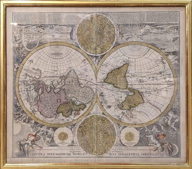
Homann, Johann Baptist (1664–1724).
Planiglobii Terrestris cum utroq Hemisphaerio Caelesti generalis exhibito.
Nürnberg, J.B. Homann, ca. 1720. Altkolorierter Kupferstich. Bildformat: 56 x 65 cm. Blattformat: 51 x 60 cm.
Bookseller reference : 973DG
|
|
|
Homan Ethel M.
A Winter under Eastern Skies: a Diary
London: Gillingham nd 1913. Hardcover. 1st edition. 258 x 164mm. Pp 219 frontis and 19pp monochrome half-tone photographs. Empty pocket on rear paste-down for missing map. Red cloth boards stamped in gilt on the spine. Signed on the front free endpaper 'Mrs Heal from Ethel M Homan 1913'. TEG. Some pages remain uncut. Some spotting throughout. Cloth a bit marked and rubbed at extremities and a 25mm split in lower joint else a Very Good copy without dust-jacket. <br/><br/> London: Gillingham, nd (?1913) hardcover
Bookseller reference : 9996
|
|
|
HOMANN Johann Baptist
Accurate Vorstellung der Orientalisch- Kayserlichen Haupt- und Residenz-Stadt Constantinopel - Carte de Constantinople
- s.d. (circa 1720), 62x53,5cm, une feuille rempliée. - Carte originale, entièrement rehaussée en couleurs, montrant la régon du Bosphore. Grande vue panoramique de Constantinople vue de Scutari en bas de la carte. Une légende nomme et localise 30 bâtiments importants, tels que le Sérail, Sainte-Sophie et plusieurs mosquées. Une vue de l'Hellespont, de la mer de Marmora et de Constantinople au loin, se trouve en haut à droite de la carte. Bel exemplaire de cette carte conçue par Johann Baptist Homann (1664-1724) - l'un des cartographes les plus renommés et fondateur de l'une des plus importantes maisons d'éditions allemandes. [ENGLISH DESCRIPTION ON DEMAND]

|
|
|
HOMANN Johann Baptist
Nova Anglia Septentrionali Americae implantata Anglorumque coloniis florentissima Geographica exhibita
- Nuremberg s.d. (circa 1716), 61,4x53cm, une feuille rempliée. - Nova Anglia Septentrionali Americae implantata Anglorumque coloniis florentissima Geographica exhibita Nuremberg | [ca 1716] | 61.4 x 53 cm | one map Beautiful copy of one of the rare maps of the American North-East in the early eighteenth century, showing the region as it was considered before the British government commissioned more in-depth cartographic studies on the subject. his map is the work of Johann Baptist Homann (1664-1724), one of the most well-known cartographers, founder of one of the most important German publishing houses. Conceived while the region was still being discovered, it shows a certain number of inaccuracies: Cape Cod is represented as an island and the port of Boston appears larger than its true size. The size of some lakes is exaggerated, whereas Lake Champlain is farther east that its actual location. Seneca Lake (New York State) is shown to be an immense sea that flows into the Hudson Valley and Lake George is then called «Lake Iroquois.» The representation of New France in the North is also inaccurate insofar as Montreal (Mont Royal) takes the shape of a huge island immediately adjacent to Lake Ontario. We also note the presence of the legendary Norumbega colony. It is also one of the very first representations of New York City: Manhattan is identified as an island captioned «N. Loch,» which helps to identify this map as a second state. Very beautiful copy. [FRENCH VERSION FOLLOWS] Edition originale et second tirage de cette carte à toutes marges, gravée sur cuivre et rehaussée en couleurs à l'époque. La carte est apparue pour la première fois dans l'Atlas Novus vers 1716 et a été rééditée pendant plusieurs décennies. Beau cartouche en bas à droite témoignant des échanges commerciaux entre Amérindiens et Européens : perles, armes, outils, alcool, textiles et fourrures, l'un des piliers économiques de la Nouvelle-Angleterre à l'époque. Cette carte très détaillée couvre la zone géographique allant de Philadelphie au Sud jusqu'à la vallée du Saint-Laurent au Nord et indique les colonies amérindiennes et européennes. Elle couvre les Etats du Maine, du New Hampshire, du Vermont, du Massachusetts, du Connecticut, du Rhode Island, de New York et de Pennsylvanie et du New Jersey. Bel exemplaire de l'une des rares cartes du Nord-Est américain du début du XVIIIème siècle, représentant la région telle qu'elle était envisagée avant que le gouvernement britannique ne commande des études cartographiques plus approfondies sur le sujet. Cette carte est l'uvre de Johann Baptist Homann (1664-1724), l'un des cartographes les plus renommés, fondateur de l'une des plus importantes maisons d'éditions allemandes. Conçue alors que la région était toujours en cours d'explorations, elle montre un certain nombre d'inexactitudes : Cape Cod y est représentée comme une île et le port de Boston apparaît plus grand que son apparence réelle. La taille de certains lacs est exagérée, tandis que le lac Champlain plus à l'Est que son emplacement réel. Le lac Seneca (état de New York) se révèle être une immense mer qui se déverse dans la vallée de l'Hudson et le lac George porte alors le nom de « lac iroquois ». La représentation de la Nouvelle-France au Nord est elle aussi inexacte dans la mesure où Montréal (Mont Royal) prend la forme d'une île immense immédiatement adjacente au lac Ontario. On notera également la présence de la colonie légendaire de Norumbega. Il s'agit en outre de l'une des toutes premières représentations de la ville de New York : Manhattan est identifiée comme une île légendée « N. Loch », ce qui aide à identifier cette carte comme deuxième état. Très bel exemplaire.

|
|
|
Homann, Johann Baptist (1664?1724)
Planiglobii Terrestris cum utroq Hemisphaerio Caelesti generalis exhibito.
Nürnberg, J.B. Homann, ca. 1720. Altkolorierter Kupferstich. Bildformat: 56 x 65 cm. Blattformat: 51 x 60 cm. + Wichtig: Für unsere Kunden in der EU erfolgt der Versand alle 14 Tage verzollt ab Deutschland / Postbank-Konto in Deutschland vorhanden +, 973DG
Bookseller reference : 973DG

|
|
|
Homann, Johann Baptist.
Grosser Atlas über die gantze Welt. Nuremberg, Homann heirs (printed by Johann Heinrich Gottfried Bieling), 1737[-1762].
Folio (340 × 535 mm). Letterpress title-page printed in red and black with an engraved map of the northern hemisphere in a polar projection, engraved frontispiece with a globe and a dozen allegorical figures (with a decorated cartouche at the foot giving the title in Latin), engraved portrait of Homann by Johann Wilhelm Winter after Johannes Kenckel, and 98 engraved maps (93 double-page, 1 larger folding in 2 sheets and 4 half-page together on a double-page plate), many with further inset maps and/or views, all with decorated cartouches, often with pictorial decoration or coats of arms; and 3 double-page engraved tables of topographic data. With the engraved title-page and all maps and tables (except for the small north polar projection on the letterpress title-page) coloured by an 18th-century hand, the maps in part or in outline. Gold-tooled red morocco (ca. 1800?) in a neo-classical style, from the workshop of or in the style of Georg Friedrich Krauss (Vienna). The Lord Wardington copy of the last edition (1737 with later substitutions by the publisher, probably issued ca. 1762) of Germany's most famous 18th-century world atlas in an exceptionally fine binding, commissioned in Vienna around 1800, and with the frontispiece and all maps coloured by an 18th-century hand. After a 40-page introduction and descriptions by Johann Gabriel Doppelmayr, the atlas contains a celestial chart in 2 hemispheres (with pictorial constellations) surrounded by 6 smaller cosmological diagrams; a Copernican solar system; a world map in eastern and western hemispheres plus 4 smaller projections (2 polar and 2 centred on Europe and the South Pacific); the usual maps of the continents and numerous regions in Europe (including postal maps and maps of river valleys); but also maps of the Black Sea and surroundings (including one with the whole of Turkey); Egypt; the Persian (Iranian) Empire; the Ottoman Empire with the Arabian peninsula and the Gulf; China; Mexico, the Caribbean and most of what is now the United States; and 4 half-page maps of British colonies in America (together on a double-page plate). From the collection of Christopher Henry Beaumont Pease, Lord Wardington (1924-2005), Sotheby's 18 Oct. 2005, lot 193. Some maps are bound out of order (5 groups in reverse order, giving 1-51, 62-52, 72-63, 82-73, 92-83, 100-93, plus 30 & 31 interchanged). Without maps 17 and 22 (Orleans and Lyonnais, but with a 1762 map of the latter with a part of the former), 5 maps very slightly shaved at the head or foot (just touching the outside of the border or the top of the lettering above the border at the head, but with no significant loss), a small tear repaired in the letterpress title-page, some edges slightly frayed, but still in very good condition. An outstanding example of Homann's great atlas in an extraordinary binding. Shirley, pp. 542-565. Tooley, Dictionary of map makers, p. 308. For the author cf. NDB.
|
|
|
homas Stamford RAFFLES. E. HAHN
Raffles of Singapore. A Biography.
Francis Aldor 1948. 8vo. First UK Edition; original terracotta pictorial cloth backstrip lettered in brown red top a very good clean copy in dustwrapper. First published in New York in 1946 this is the standard life of the founder of Singapore. Issued two years later the UK edition is very scarce especially in this condition. Francis Aldor, hardcover
Bookseller reference : 26724
|
|
|
HOMBRON Jacques Bernard
Aventures les plus curieuses des voyageurs. Coup d'oeil autour du monde d'après les relations anciennes et modernes et des documents recueillis sur les lieux
- Belin-Leprieur et Morizot, Paris s.d. (circa 1860), 15,5x23,5cm, reliure de l'éditeur. - Edition illustrée de gravures hors-texte en noir et en couleurs. Reliure en demi chagrin sapin, dos à quatre fins nerfs ornés de triples caissons dorés agrémentés de pointilés dorés, petites éraflures sur le dos, encadrements d'un jeu de filets à froid sur les plats de cartonnage sapin, gardes et contreplats de soie moirée blanche légèrement salies comme fréquemment, toutes tranches dorées. Quelques petites rousseurs sans gravité. [ENGLISH DESCRIPTION ON DEMAND]

|
|
|
HOMBRON, (JACQUES BERNARD).
Aventures les plus curieuses des Voyageurs Coup D'oeil autour du Monde d'apres les Relations anciennes et modernes et de Documents recueillis sur les lieux. Ouvrage imité des Aventures des Voyageurs par P. Blanchard. 2 vols.
Paris, Belin-Leprieur et Morizot, 1847. Bound in 2 profusely gilt and ornamented in different colours, original full cloth. Binding of vol. 1 rubbed and tears in hinges. Corners bumped, spine ends worn. All edges gilt. Occasionally brownspotted. Stamp on title. 2 frontispieces. (1),III,496 (1),476 pp. 38 fine wood-engraved plates and many textillustr.
|
|
|
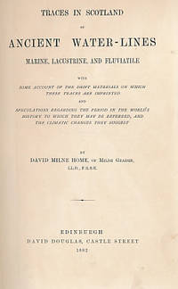
Home David Milne
Traces in Scotland of Ancient Water-Lines Marine Lacustrine and Fluviatile with Some Account of the Drift Materials on Which These Traces are Imprinted.
Edinburgh: David Douglas. G : in Good condition without dust jacket. 1882. First Edition. Green/gilt hardback cloth cover. 230mm x 140mm 9" x 6". 149pp. '. and speculations regarding the period in the world's history to which they may be referred and the climatic changes they suggest.'. . David Douglas hardcover
Bookseller reference : e6277
|
|
|
Home Gordon.
BEAUTIFUL BRITAIN: THE ROMANCE OF LONDON.
A & C Black 1924. Hardcover. Used; Good. No dust jacket. <p><i><strong>Fast Dispatch. Expedited UK Delivery Available. Excellent Customer Service. </strong></i> <br/><br/>Bookbarn International Inventory #1668423</p> A & C Black hardcover
Bookseller reference : 1668423
|
|
|
Home Gordon.
BEAUTIFUL BRITAIN: THE ROMANCE OF LONDON.
A & C Black 1924. Hardcover. Used; Good. No dust jacket. <p><i><strong>Fast Dispatch. Expedited UK Delivery Available. Excellent Customer Service. </strong></i> <br/><br/>Bookbarn International Inventory #1418716</p> A & C Black hardcover
Bookseller reference : 1418716
|
|
|
Home Gordon
Normandy: The Scenery & Romance of Its Ancient Towns; depicted by Gordon Home
London / New York: J. M. Dent & Co.; E. P. Dutton & Co 1905. Hardcover. Near Fine. xv 1 248 p. color frontispiece and 23 leaves of color plates: in-text illustrations; 23 cm. Dark blue cloth with gilt-stamped spine and cover titles. Spine title: Normandy in Colour. Spine and front cover illustrations. Top page edges gilt. Frontispiece is tissue-guarded. Includes index. A beautifully illustrated guide to Normandy France. In Near Fine Condition: corners lightly rubbed; clean and bright. <br/><br/> J. M. Dent & Co.; E. P. Dutton & Co hardcover
Bookseller reference : 006893

|
|
|
Home Gordon
Normandy: The Scenery & Romance of Its Ancient Towns
London: Dent 1905. First edition. Hardcover. Very Good. First printing. 8vo. Black cloth boards stamped in gilt on the spine and upper panel also with pictorial stamping on the spine and upper panel in red. Pp xiii 248 tissue-protected frontis and 23 full-page colour plates. 9 line illustrations in the text. Name of ownership 1962 on the front pastedown and another 1982 on the front free endpaper else a clean unmarked copy in a tight binding without dust jacket. The cloth is showing some wear qt the head and tail of the spine. The pages are untrimmed aqt the tail and the fore-edge. <br/><br/> Dent hardcover
Bookseller reference : 93262

|
|
|
Home Gordon
Stratford-on-Avon. A Sketch-book
London: A & C Black. No date. Octavo Size approx 15.5 x 22.8cm. VERY GOOD condition. Small sticker stain to lower front edge Illustrated with 24 sketches by Gordon Home. Unpaginated 26 . Softcover. A & C Black paperback
Bookseller reference : BIB176780

|
|
|
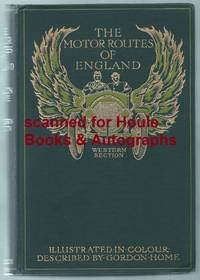
Home Gordon
The Motor Routes of England. Western Section
<p>DRINKING AND DRIVING - COGNAC</p><p>First edition. Octavo. Color frontispiece and 15 full page color plates; large folding map at end. Original dark green pictorial cloth with winged auto and two persons in gilt and olive green; t.e.g. No dust jacket. No foxing. Fresh bright tight fine copy. 337 pages six advertisements. No signatures or bookplates.</p><p>Includes full page ad for Gautier Freres Cognac; "Fine Spirit in the pocket is a desirability."</p> Adam and Charles Black hardcover
Bookseller reference : 2221585
|
|
|
Home Gordon
The Motor Routes of France to the Chateaux of Touraine Biarritz the Pyrenees the Riviera & the Rhone Valley
London: A. & C. Black 1910. Cnrs and head and tail of spine worn; cvrs marked; contents vg; 444p plates some col illus maps. Size: 8vo - over 7�" - 9�" tall. First Edition. Original Cloth. Good reading copy/No Jacket. 8vo - over 7�" - 9�" tall. Ex-School Library. A. & C. Black Hardcover
Bookseller reference : 21779
|
|
|
Home Gordon
Through Yorkshire: The County of Broad Acres
London: J. M. Dent 1922. Hardcover. No jacket. Boards and spine are marked. Light wear on spine ends and leading corners. Foxing on page block early and closing pages. Binding is intact contents are clean and clear. AM. Hardcover. Good/No Dust Jacket. Used. J. M. Dent Hardcover
Bookseller reference : 426414
|
|
|
Home Gordon
What to see in the Channel Islands
London: Black. Good/No Jacket. 1925. Hardback. 12mo - over 6�" - 7�" tall 6 x 7"; 31 pages; grey cloth with brown title and decorations to front board boards are scuffed; 15 wonderful colour illustrations title page refers to 16 illustrations but list of illustrations at rear of book clearly gives 15; . Black hardcover
Bookseller reference : 9250
|
|
|
Home Gordon
Yorkshire Vales and Wolds
A. & C. Black London 1908. Hardcover 1908 Very Good blue cloth with gilt design includes a fold-out map. Hardcover. Very Good/No Dustjacket. A. & C. Black London
Bookseller reference : 005848
|
|
|
Home Gordon
The Motor Routes of England. Western Section
<p>DRINKING AND DRIVING - COGNAC</p><p>First edition. Octavo. Color frontispiece and 15 full page color plates; large folding map at end. Original dark green pictorial cloth with winged auto and two persons in gilt and olive green; t.e.g. No dust jacket. No foxing. Fresh bright tight fine copy. 337 pages six advertisements. No signatures or bookplates.</p><p>Includes full page ad for Gautier Freres Cognac; "Fine Spirit in the pocket is a desirability."</p> Adam and Charles Black hardcover books
Bookseller reference : 2221585
|
|
|
Home, Gordon
Through Yorkshire: The County of Broad Acres
Hardcover. No jacket. Boards and spine are marked. Light wear on spine ends and leading corners. Foxing on page block, early and closing pages. Binding is intact, contents are clean and clear. AM Used

|
|
|
Homem, Diogo
Atlas universal. ? (Faks. der Ausg. der russischen Nationalbibliothek Sankt Petersburg von 1565).
Barcelona, Moleiro, 2000?2002. Folio und quart. 331 S. Mit (20) Bl. mit faks. Karten. Leinen- und Lederband in Lederbox. + Wichtig: Für unsere Kunden in der EU erfolgt der Versand alle 14 Tage verzollt ab Deutschland / Postbank-Konto in Deutschland vorhanden +, A|B 2 Bände. [2 Warenabbildungen]
Bookseller reference : 30664AB

|
|
|
Homes A. M.
Bruges Insight Pocket Guide
Apa Publications Pte Ltd 2004. 3rd Revised edition. Paperback. Used; Good. <p><i><strong>Fast Dispatch. Expedited UK Delivery Available. Excellent Customer Service. </strong></i> <br/><br/>Bookbarn International Inventory #2437112</p> Apa Publications Pte Ltd paperback
Bookseller reference : 2437112 ISBN : 9812581499 9789812581495
|
|
|
HOMET Marcel F.;
On the Trail of the Sun Gods
London Neville Spearman 1965 First edition. . original cloth spine title lettering fine and clean in good dust jacket price clipped a little used. . 8vo 22 x 15 cm; 272 pp 31 plates from photos numerous illustrations from drawings bibliography appendix. . The author describes his discoveries in the Amazon region in search for lost cities of sun worshippers facing death and dangers covering much of same ground as the legendary Colonel Fawcett. He links ancient civilizations in Brazil and Peru with those of Egypt and the middle east in a fascinating and well-illustrated account. A picture of this book is available on request by email. London, Neville Spearman, [1965], First edition. hardcover
Bookseller reference : J13849
|
|
|
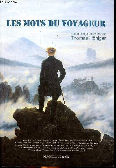
Honiger Thomas
Les mots du voyageur
Magellan & Cie. 2013. In-8. Broché. Bon état, Couv. convenable, Dos satisfaisant, Intérieur frais. 166 pages.. . . . Classification Dewey : 910-Géographie générale. Voyages
Bookseller reference : R260265222
|
|
|
Honoré, Bernard.
Septentrion - Revue archéologique trimestrielle - Tome 10, 1980 (43)
Revue Septentrion, Tome 10, fascicule 43, Fédération archéologique Septentrion, Saint-Martin-lez-Boulogne, 1980. In-4, agrafé sous couverture illustrée, paginé pp. 41-60. Remarques et hypothèses sur le développement urbain de Thérouanne (Pas-de-Calais), par Bernard Honoré - Chronique régionale.
Bookseller reference : 5963
|
|
|
Honan Mark; Harcombe David
Lonely Planet. Solomon Islands
Melbourne: Lonely Planet 1997. 281pp index glossary col ills maps. Or pictorial card. Top front corner creased. Third Edition. Soft Cover. Very Good. 8vo. Lonely Planet Paperback
Bookseller reference : 031981 ISBN : 0864424051 9780864424051

|
|
|
Honan Mark
Switzerland Lonely Planet Travel Guides
Lonely Planet Publications 2003. Paperback. Used; Very Good. <p><i><strong>Fast Dispatch. Expedited UK Delivery Available. Excellent Customer Service. </strong></i> <br/><br/>Bookbarn International Inventory #2968488</p> Lonely Planet Publications paperback
Bookseller reference : 2968488 ISBN : 174059228x 9781740592284

|
|
|
Honey W B
English Glass. Britain in Pictures No 99
London: Collins. G: in Good condition with rubbed and chipped dust jacket. Browning within. 1946. First Edition. Pea green board cover. 230mm x 170mm 9" x 7". 48pp. . Collins unknown
Bookseller reference : bip099a

|
|
|
Honey Naylor
Insight Compact Guide Bermuda
Apa Publications Pte Ltd 2000. No binding. Used; Good. <p><i><strong>Fast Dispatch. Expedited UK Delivery Available. Excellent Customer Service. </strong></i> <br/><br/>Bookbarn International Inventory #2830129</p> Apa Publications Pte Ltd unknown
Bookseller reference : 2830129 ISBN : 9812340416 9789812340412

|
|
|
HONG KONG TRAVEL POSTER.
Give Yourself Time. Hong Kong More Than You'll Bargain For.
Hong Kong.: Hong Kong Tourist Association. no date. circa1970. Colour photographic poster showing an image of Hong Kong from the Peak looking across the harbour to Kowloon a second image below shows a Chinese dancer. Pin holes at corners lower right corner trifle creased two very small nicks in the surface of the left hand blue border. 80 x 55cm. Travel poster for Hong Kong with an unintentionally humorous title! . Hong Kong Tourist Association. unknown
Bookseller reference : 143944

|
|
|
HONG KONG TRAVEL POSTER PAN AM IMAGE.
Hong Kong.
no date circa1960. Colour photographic poster from a Pan Am photograph showing Hong Kong Island with a very different skyline to that of today in the background and a Chinese junk in the foreground. Measures 90 x 64.3cm. Several short tears from margins neatly mended creasing particularly evident along margins a little light marking and a few small places of surface loss on image. Visible on the reverse only is some thining of paper in three places and a little tape at corners again only visible on the reverse. These faults not do not detract from the overall striking appearance of the poster. Good copy. . unknown
Bookseller reference : 151301

|
|
|
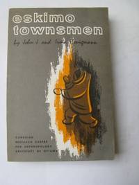
Honigmann John J. and Irma
ESKIMO TOWNSMEN
Canadian Research Centre for Anthropology 1965. Softcover. Very Good. 1st Edition: xx 278pp illustrated 6 diagrams 38tables 151 b/w plates. Card covers. An anthropological study based on the author's researches at Frobisher Bay in 1963. very Good Quantity Available: 1. Shipped Weight: Under 1 kilogram. Category: Arctic & Antarctic; Antarctic; Pictures of this item not already displayed here available upon request. Inventory No: 2315. . Canadian Research Centre for Anthropology paperback
Bookseller reference : 2315
|
|
|
Honnywill Eleanor
THE CHALLENGE OF ANTARCTICA
Anthony Nelson 1984. Cloth. Good. 1984 Revised and Expanded Edition; 127pp illustrated 36 b/w photographs illustrations 7 maps. Foreword by Sir Vivian Fuchs. Green cloth covers with gilt titling to spine in price clipped dustjacket. History of the Antarctic from the early searches for a "South land"through the age of discovery to the present time covers Captain CookRoss de Gerlache Scott Shackelton and Mawson. Quantity Available: 1. Shipped Weight: Under 1 kilogram. Category: Arctic & Antarctic; Antarctic; ISBN: 0904614093. ISBN/EAN: 9780904614091. Pictures of this item not already displayed here available upon request. Inventory No: 2543. . 9780904614091 Anthony Nelson hardcover
Bookseller reference : 2543 ISBN : 0904614093 9780904614091

|
|
|
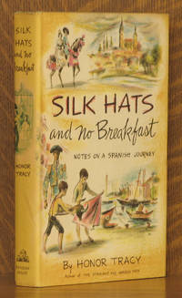
Honor Tracy
SILK HATS AND NO BREAKFAST - NOTES ON A SPANISH JOURNEY
New York: Random House 1958. Stated First printing. Very Good/very good. 5 1/2 x 8 1/4 inches. 207 pages. First printing stated on copyright page. Condition of the book is Very Good; Exterior excellent text is very clean binding is tight. Dust jacket is Very Good; spine slightly toned not price-clipped $3.50. STK <br/><br/> Random House unknown
Bookseller reference : 28093
|
|
|
Honour Hugh
Chinoiserie: The Vision of Cathay
London: John Murray 1961 8vo. pp. viii 294 4 col. plates 144 illus. on plates text illus. 2 errata slips t.e. dyed gilt cloth. Fine in slightly rubbed dust jacket. Arntzen P18. London: John Murray, 1961 hardcover
Bookseller reference : S342
|
|
 Receive by email
 Download as PDF document
 RSS feed


