|
|
|
HARITA UMUM MÜDÜRLÜGÜ = MAP GENERAL DIRECTORY].
[MAP of TURKISH BALKANS, BULGARIA] 15. Kazanlik. 16. Hasköy. 21. Karlova. 22. Filibe (Plovdiv). Mübde-i Tûl Paris'den itibâr olunmusdur. [Plovdiv, Karlovo, Haskovo, Kizanlik / Kazanlyk - Bulgaria].
Very Good Turkish, Ottoman (1500-1928) Original color map on cloth. A little foxing on cloth. Very good. Folded. Oblong atlas folio. (66 x 72 cm). In Ottoman script. Scale: 1/210.000. Ottoman cities in Bulgaria. A rare Ottoman map of Balkans with Turkish place names for the period of pre-Balkan Wars, (1912-1913). Very important for onomastics and historical geography. Written 'Paris -French meridian- was accepted as the 0 meridian'. The Paris meridian is a meridian line running through the Paris Observatory in Paris, France-now longitude 2°20'14.03" east. It was a long-standing rival to the Greenwich meridian as the prime meridian of the world. Personal stamp of Muhiddin Pasha on cloth, under the printed descriptive texts. It's from the collection of him. Hasan Muhiddin Pasha [Çanga], (1866-1944), who was a lieutenant in Hedjaz Army of the Ottoman Empire in 1887. After he suppressed the rebellion in Yemen, 1891, his rank was promoted to the 'major'. After the Imam Yahya rebellion in Yemen, 1904, he prepared a report for the Ottoman government. He also took part in Ethiopia, Sudan, Yemen, Arabian Peninsula for various military duties. After promotion to division command, he was provincial president of CHP (Republican People's Party). He was a very important politic and diplomatic figure for the last period of Ottoman and early Republican Turkey. Not in Tooley. Extremely rare.
|
|
|
HARITA UMUM MÜDÜRLÜGÜ = MAP GENERAL DIRECTORY].
[MAP of TURKISH BALKANS, BULGARIA] Eski Zagra. [Stara Zagora - Old Zagora].
Very Good Turkish, Ottoman (1500-1928) Original color map on cloth. A little foxing on cloth. Very good. Folded. Oblong atlas folio. (66 x 72 cm). In Ottoman script. Scale: 1/210.000. Ottoman sanjaks in Balkans, Bulgaria. A very detailed map of Old Zagora. A rare Ottoman map of Balkans with Turkish place names for the period of pre-Balkan Wars, (1912-1913). Very important for onomastics and historical geography. Extremely rare.
|
|
|
HARITA UMUM MÜDÜRLÜGÜ = MAP GENERAL DIRECTORY].
[MAP of TURKISH BALKANS, BULGARIA] Filibe - Hasköy. [Plovdiv - Haskovo].
Very Good Turkish, Ottoman (1500-1928) Original color map on cloth. A little foxing on cloth. Very good. Folded. Oblong atlas folio. (66 x 72 cm). In Ottoman script. Scale: 1/210.000. Ottoman sanjaks in Balkans, Bulgaria. A very detailed map of Plovdiv and Haskovo. A rare Ottoman map of Balkans with Turkish place names for the period of pre-Balkan Wars, (1912-1913). Very important for onomastics and historical geography. Extremely rare.
|
|
|
HARITA UMUM MÜDÜRLÜGÜ = MAP GENERAL DIRECTORY].
[MAP of TURKISH BALKANS, BULGARIA] Filibe. [Plovdiv].
Very Good Turkish, Ottoman (1500-1928) Original color map on cloth. A little foxing on cloth. Very good. Folded. Oblong atlas folio. (66 x 72 cm). In Ottoman script. Scale: 1/210.000. Ottoman sanjaks in Balkans, Bulgaria. A very detailed map of Plovdiv. A rare Ottoman map of Balkans with Turkish place names for the period of pre-Balkan Wars, (1912-1913). Very important for onomastics and historical geography. Extremely rare.
|
|
|
HARITA UMUM MÜDÜRLÜGÜ = MAP GENERAL DIRECTORY].
[MAP of TURKISH BALKANS, GREECE, MACEDONIA] 28. Nurekob. 29. Siroz. 34. Usturumçe (Macedonia). 35. Teviran. Mübde-i Tûl Paris'den itibâr olunmusdur. [Serres, Macedonia, Greece].
Very Good Turkish, Ottoman (1500-1928) Original color map on cloth. A little foxing on cloth. Very good. Folded. Oblong atlas folio. (66 x 72 cm). In Ottoman script. Scale: 1/210.000. Ottoman sanjaks in Greece, mostly in Greek Macedonia. A rare Ottoman map of Balkans with Turkish place names for the period of pre-Balkan Wars, (1912-1913). Very important for onomastics and historical geography. Written 'Paris -French meridian- was accepted as the 0 meridian'. The Paris meridian is a meridian line running through the Paris Observatory in Paris, France-now longitude 2°20'14.03" east. It was a long-standing rival to the Greenwich meridian as the prime meridian of the world. Personal stamp of Muhiddin Pasha on cloth, under the printed descriptive texts. It's from the collection of him. Hasan Muhiddin Pasha [Çanga], (1866-1944), who was a lieutenant in Hedjaz Army of the Ottoman Empire in 1887. After he suppressed the rebellion in Yemen, 1891, his rank was promoted to the 'major'. After the Imam Yahya rebellion in Yemen, 1904, he prepared a report for the Ottoman government. He also took part in Ethiopia, Sudan, Yemen, Arabian Peninsula for various military duties. After promotion to division command, he was provincial president of CHP (Republican People's Party). He was a very important politic and diplomatic figure for the last period of Ottoman and early Republican Turkey. Not in Tooley. Extremely rare.
|
|
|
HARITA UMUM MÜDÜRLÜGÜ = MAP GENERAL DIRECTORY].
[MAP of TURKISH BALKANS, GREECE, MACEDONIA] 40. Istib. 41. Vodina. 46. Kirçova. 47. Manastir. Mübde-i Tûl Paris'den itibâr olunmusdur. [Stip, Edessa, Adende, Monaster; Macedonia, Greece].
Very Good Turkish, Ottoman (1500-1928) Original color map on cloth. A little foxing on cloth. Very good. Folded. Oblong atlas folio. (66 x 72 cm). In Ottoman script. Scale: 1/210.000. Ottoman sanjaks in Greece, mostly in Greek Macedonia. A rare Ottoman map of Balkans with Turkish place names for the period of pre-Balkan Wars, (1912-1913). Very important for onomastics and historical geography. Written 'Paris -French meridian- was accepted as the 0 meridian'. The Paris meridian is a meridian line running through the Paris Observatory in Paris, France-now longitude 2°20'14.03" east. It was a long-standing rival to the Greenwich meridian as the prime meridian of the world. Personal stamp of Muhiddin Pasha on cloth, under the printed descriptive texts. It's from the collection of him. Hasan Muhiddin Pasha [Çanga], (1866-1944), who was a lieutenant in Hedjaz Army of the Ottoman Empire in 1887. After he suppressed the rebellion in Yemen, 1891, his rank was promoted to the 'major'. After the Imam Yahya rebellion in Yemen, 1904, he prepared a report for the Ottoman government. He also took part in Ethiopia, Sudan, Yemen, Arabian Peninsula for various military duties. After promotion to division command, he was provincial president of CHP (Republican People's Party). He was a very important politic and diplomatic figure for the last period of Ottoman and early Republican Turkey. Not in Tooley. Extremely rare.
|
|
|
HARITA UMUM MÜDÜRLÜGÜ = MAP GENERAL DIRECTORY].
[MAP of TURKISH BALKANS, GREECE, THESSALY] 50. Narda (Yunanistan). 51. Preveze (Yunanistan). 67. Tirhala (Yunanistan). 70. Agrinyon (Yunanistan-Teselya). Mübde-i Tûl Paris'den itibâr olunmusdur. [Arta (Yunanistan), Preveza (Greece), Sandjak of Tirhala (Thessaly-Greece), Agrinio (Thessaly-Greece)]
Very Good Turkish, Ottoman (1500-1928) Original color map on cloth. A little foxing on cloth. Very good. Folded. Oblong atlas folio. (66 x 72 cm). In Ottoman script. Scale: 1/210.000. Ottoman sanjaks in Greece, mostly in Thessaly. A rare Ottoman map of Balkans with Turkish place names for the period of pre-Balkan Wars, (1912-1913). Very important for onomastics and historical geography. Written 'Paris -French meridian- was accepted as the 0 meridian'. The Paris meridian is a meridian line running through the Paris Observatory in Paris, France-now longitude 2°20'14.03" east. It was a long-standing rival to the Greenwich meridian as the prime meridian of the world. Personal stamp of Muhiddin Pasha on cloth, under the printed descriptive texts. It's from the collection of him. Hasan Muhiddin Pasha [Çanga], (1866-1944), who was a lieutenant in Hedjaz Army of the Ottoman Empire in 1887. After he suppressed the rebellion in Yemen, 1891, his rank was promoted to the 'major'. After the Imam Yahya rebellion in Yemen, 1904, he prepared a report for the Ottoman government. He also took part in Ethiopia, Sudan, Yemen, Arabian Peninsula for various military duties. After promotion to division command, he was provincial president of CHP (Republican People's Party). He was a very important politic and diplomatic figure for the last period of Ottoman and early Republican Turkey. Not in Tooley. Extremely rare.
|
|
|
HARITA UMUM MÜDÜRLÜGÜ = MAP GENERAL DIRECTORY].
[MAP of TURKISH BALKANS, GREECE, THESSALY] 65. Iskoplus (Üsküplo-Uskublo) (Yunanistan). 66. Galos (Teselya, Yunanistan). 68. Egriboz. 69. Lami (Izdin) (Thesalya, Yunanistan). Mübde-i Tûl Paris'den itibâr olunmusdur. [Volos, Skopelos, Euboea, Lamia (Thessaly, Greece).
Very Good Turkish, Ottoman (1500-1928) Original color map on cloth. A little foxing on cloth. Very good. Folded. Oblong atlas folio. (66 x 72 cm). In Ottoman script. Scale: 1/210.000. Ottoman sanjaks in Greece, mostly in Thessaly. A rare Ottoman map of Balkans with Turkish place names for the period of pre-Balkan Wars, (1912-1913). Very important for onomastics and historical geography. Written 'Paris -French meridian- was accepted as the 0 meridian'. The Paris meridian is a meridian line running through the Paris Observatory in Paris, France-now longitude 2°20'14.03" east. It was a long-standing rival to the Greenwich meridian as the prime meridian of the world. Personal stamp of Muhiddin Pasha on cloth, under the printed descriptive texts. It's from the collection of him. Hasan Muhiddin Pasha [Çanga], (1866-1944), who was a lieutenant in Hedjaz Army of the Ottoman Empire in 1887. After he suppressed the rebellion in Yemen, 1891, his rank was promoted to the 'major'. After the Imam Yahya rebellion in Yemen, 1904, he prepared a report for the Ottoman government. He also took part in Ethiopia, Sudan, Yemen, Arabian Peninsula for various military duties. After promotion to division command, he was provincial president of CHP (Republican People's Party). He was a very important politic and diplomatic figure for the last period of Ottoman and early Republican Turkey. Not in Tooley. Extremely rare.
|
|
|
HARITA UMUM MÜDÜRLÜGÜ = MAP GENERAL DIRECTORY].
[MAP of TURKISH BALKANS, GREECE] 17. Gümülcine. 18. Karaagaç. 23. Pasmakli. 24. Kavala. Mübde-i Tûl Paris'den itibâr olunmusdur. [Komotini, Ftelia, Kavala, et alli].
Very Good Turkish, Ottoman (1500-1928) Original color map on cloth. A little foxing on cloth. Very good. Folded. Oblong atlas folio. (66 x 72 cm). In Ottoman script. Scale: 1/210.000. Ottoman sanjaks in Greece. A rare Ottoman map of Balkans with Turkish place names for the period of pre-Balkan Wars, (1912-1913). Very important for onomastics and historical geography. Written 'Paris -French meridian- was accepted as the 0 meridian'. The Paris meridian is a meridian line running through the Paris Observatory in Paris, France-now longitude 2°20'14.03" east. It was a long-standing rival to the Greenwich meridian as the prime meridian of the world. Personal stamp of Muhiddin Pasha on cloth, under the printed descriptive texts. It's from the collection of him. Hasan Muhiddin Pasha [Çanga], (1866-1944), who was a lieutenant in Hedjaz Army of the Ottoman Empire in 1887. After he suppressed the rebellion in Yemen, 1891, his rank was promoted to the 'major'. After the Imam Yahya rebellion in Yemen, 1904, he prepared a report for the Ottoman government. He also took part in Ethiopia, Sudan, Yemen, Arabian Peninsula for various military duties. After promotion to division command, he was provincial president of CHP (Republican People's Party). He was a very important politic and diplomatic figure for the last period of Ottoman and early Republican Turkey. Not in Tooley. Extremely rare.
|
|
|
HARITA UMUM MÜDÜRLÜGÜ = MAP GENERAL DIRECTORY].
[MAP of TURKISH BALKANS, GREECE] 25. Kareles. 30. Poliroz. 31. Kesendire. 36. Selânik. 37. Litohor. Mübde-i Tûl Paris'den itibâr olunmusdur. [Litochoro, Thessaloniki (Salonica-Salonique), Kassandra, Kassandreia, Polygyros, et alli.].
Very Good Turkish, Ottoman (1500-1928) Original color map on cloth. A little foxing on cloth. Very good. Folded. Oblong atlas folio. (66 x 72 cm). In Ottoman script. Scale: 1/210.000. Ottoman sanjaks in Greece. A rare Ottoman map of Balkans with Turkish place names for the period of pre-Balkan Wars, (1912-1913). Very important for onomastics and historical geography. Written 'Paris -French meridian- was accepted as the 0 meridian'. The Paris meridian is a meridian line running through the Paris Observatory in Paris, France-now longitude 2°20'14.03" east. It was a long-standing rival to the Greenwich meridian as the prime meridian of the world. Personal stamp of Muhiddin Pasha on cloth, under the printed descriptive texts. It's from the collection of him. Hasan Muhiddin Pasha [Çanga], (1866-1944), who was a lieutenant in Hedjaz Army of the Ottoman Empire in 1887. After he suppressed the rebellion in Yemen, 1891, his rank was promoted to the 'major'. After the Imam Yahya rebellion in Yemen, 1904, he prepared a report for the Ottoman government. He also took part in Ethiopia, Sudan, Yemen, Arabian Peninsula for various military duties. After promotion to division command, he was provincial president of CHP (Republican People's Party). He was a very important politic and diplomatic figure for the last period of Ottoman and early Republican Turkey. Not in Tooley. Extremely rare.
|
|
|
HARITA UMUM MÜDÜRLÜGÜ = MAP GENERAL DIRECTORY].
[MAP of TURKISH BALKANS, MACEDONIA] Usturumca (Strumica), Siroz (Serres), Toyran (Doyran), Nevre-i Kob.
Very Good Turkish, Ottoman (1500-1928) Original color map on cloth. A little foxing on cloth. Very good. Folded. Oblong atlas folio. (66 x 72 cm). In Ottoman script. Scale: 1/210.000. Ottoman sanjaks in Balkans, Macedonia. A very detailed map of Old Zagora. A rare Ottoman map of Balkans with Turkish place names for the period of pre-Balkan Wars, (1912-1913). Very important for onomastics and historical geography. Extremely rare.
|
|
|
HARITA UMUM MÜDÜRLÜGÜ = MAP GENERAL DIRECTORY].
[MAP of TURKISH BALKANS, MACEDONIAN GREECE, THESSALY] 42. Kirefrite. 43. Alasonya. 48. Nasliç, Naslig. 49. Yanya. Mübde-i Tûl Paris'den itibâr olunmusdur. [Elassona, Neapoli, Ioannina (Ottoman sandjakss in Thessaly, and Macedonian Greece).
Very Good Turkish, Ottoman (1500-1928) Original color map on cloth. A little foxing on cloth. Very good. Folded. Oblong atlas folio. (66 x 72 cm). In Ottoman script. Scale: 1/210.000. Ottoman sanjaks in Greece, mostly in Thessaly and Macedonian Greece. A rare Ottoman map of Balkans with Turkish place names for the period of pre-Balkan Wars, (1912-1913). Very important for onomastics and historical geography. Written 'Paris -French meridian- was accepted as the 0 meridian'. The Paris meridian is a meridian line running through the Paris Observatory in Paris, France-now longitude 2°20'14.03" east. It was a long-standing rival to the Greenwich meridian as the prime meridian of the world. Personal stamp of Muhiddin Pasha on cloth, under the printed descriptive texts. It's from the collection of him. Hasan Muhiddin Pasha [Çanga], (1866-1944), who was a lieutenant in Hedjaz Army of the Ottoman Empire in 1887. After he suppressed the rebellion in Yemen, 1891, his rank was promoted to the 'major'. After the Imam Yahya rebellion in Yemen, 1904, he prepared a report for the Ottoman government. He also took part in Ethiopia, Sudan, Yemen, Arabian Peninsula for various military duties. After promotion to division command, he was provincial president of CHP (Republican People's Party). He was a very important politic and diplomatic figure for the last period of Ottoman and early Republican Turkey. Not in Tooley. Extremely rare.
|
|
|
HARITA UMUM MÜDÜRLÜGÜ = MAP GENERAL DIRECTORY].
[MAP of TURKISH BALKANS] 26. Otluk Köyü. 27. Samako. 32. Sofiye. 33. Cumabâla. Mübde-i Tûl Paris'den itibâr olunmusdur.
Very Good Turkish, Ottoman (1500-1928) Original color map on cloth. A little foxing on cloth. Very good. Folded. Oblong atlas folio. (66 x 72 cm). In Ottoman script. Scale: 1/210.000. Ottoman sanjaks in Balkans. A rare Ottoman map of Balkans with Turkish place names for the period of pre-Balkan Wars, (1912-1913). Very important for onomastics and historical geography. Written 'Paris -French meridian- was accepted as the 0 meridian'. The Paris meridian is a meridian line running through the Paris Observatory in Paris, France-now longitude 2°20'14.03" east. It was a long-standing rival to the Greenwich meridian as the prime meridian of the world. Personal stamp of Muhiddin Pasha on cloth, under the printed descriptive texts. It's from the collection of him. Hasan Muhiddin Pasha [Çanga], (1866-1944), who was a lieutenant in Hedjaz Army of the Ottoman Empire in 1887. After he suppressed the rebellion in Yemen, 1891, his rank was promoted to the 'major'. After the Imam Yahya rebellion in Yemen, 1904, he prepared a report for the Ottoman government. He also took part in Ethiopia, Sudan, Yemen, Arabian Peninsula for various military duties. After promotion to division command, he was provincial president of CHP (Republican People's Party). He was a very important politic and diplomatic figure for the last period of Ottoman and early Republican Turkey. Not in Tooley. Extremely rare.
|
|
|
HARITA UMUM MÜDÜRLÜGÜ = MAP GENERAL DIRECTORY].
[MAP of TURKISH BALKANS] 54. Debre-bala (Makedonya). 55. Ilbasan (Elbasan Sandjak -Arnavutluk-). 61. Nis Sandjak (Sirbistan). 62. Draç Sandjak (Arnavutluk). Mübde-i Tûl Paris'den itibâr olunmusdur. [Debar (Macedonia), Elbasan Sandjak (Albania), Nish (Serbia), Durras (Albania)].
Very Good Turkish, Ottoman (1500-1928) Original color map on cloth. A little foxing on cloth. Very good. Folded. Oblong atlas folio. (66 x 72 cm). In Ottoman script. Scale: 1/210.000. Ottoman sanjaks in Albania, Macedonia, Greece and Serbia. A rare Ottoman map of Balkans with Turkish place names for the period of pre-Balkan Wars, (1912-1913). Very important for onomastics and historical geography. Written 'Paris -French meridian- was accepted as the 0 meridian'. The Paris meridian is a meridian line running through the Paris Observatory in Paris, France-now longitude 2°20'14.03" east. It was a long-standing rival to the Greenwich meridian as the prime meridian of the world. Personal stamp of Muhiddin Pasha on cloth, under the printed descriptive texts. It's from the collection of him. Hasan Muhiddin Pasha [Çanga], (1866-1944), who was a lieutenant in Hedjaz Army of the Ottoman Empire in 1887. After he suppressed the rebellion in Yemen, 1891, his rank was promoted to the 'major'. After the Imam Yahya rebellion in Yemen, 1904, he prepared a report for the Ottoman government. He also took part in Ethiopia, Sudan, Yemen, Arabian Peninsula for various military duties. After promotion to division command, he was provincial president of CHP (Republican People's Party). He was a very important politic and diplomatic figure for the last period of Ottoman and early Republican Turkey. Not in Tooley. Extremely rare.
|
|
|
HARITA UMUM MÜDÜRLÜGÜ = MAP GENERAL DIRECTORY].
[MAP of TURKISH BALKANS] 58. Parga, 71. Liyapidis, 72-73. Yunan Denizi. Mübde-i Tûl Paris'den itibâr olunmusdur. [Parga, Liapidis, Greek Sea].
Very Good Turkish, Ottoman (1500-1928) Original color map on cloth. A little foxing on cloth. Very good. Folded. Oblong atlas folio. (66 x 72 cm). In Ottoman script. Scale: 1/210.000. A rare Ottoman map of Balkans with Turkish place names for the period of pre-Balkan Wars, (1912-1913). Very important for onomastics and historical geography. Ottoman Greece. Written 'Paris -French meridian- was accepted as the 0 meridian'. The Paris meridian is a meridian line running through the Paris Observatory in Paris, France-now longitude 2°20'14.03" east. It was a long-standing rival to the Greenwich meridian as the prime meridian of the world. Personal stamp of Muhiddin Pasha on cloth, under the printed descriptive texts. It's from the collection of him. Hasan Muhiddin Pasha [Çanga], (1866-1944), who was a lieutenant in Hedjaz Army of the Ottoman Empire in 1887. After he suppressed the rebellion in Yemen, 1891, his rank was promoted to the 'major'. After the Imam Yahya rebellion in Yemen, 1904, he prepared a report for the Ottoman government. He also took part in Ethiopia, Sudan, Yemen, Arabian Peninsula for various military duties. After promotion to division command, he was provincial president of CHP (Republican People's Party). He was a very important politic and diplomatic figure for the last period of Ottoman and early Republican Turkey. Not in Tooley. Extremely rare.
|
|
|
HARITA UMUM MÜDÜRLÜGÜ].
[MAP EAST ANATOLIA - CAUCASIA] Kars, Kutayisi, Tiflis, Batum. [Kars, Kutaisi, Tbilis, Batoum].
Very Good Turkish, Ottoman (1500-1928) Original color map. Atlas folio. (65 x 44 cm). In Ottoman script. Scale: 1/400.000. [MAP] Kars, Kutayisi, Tiflis, Batum. [Kars, Kutaisi, Tbilis, Batoum]. Extremely rare. Not in TBMM Library Map collection.
|
|
|
HARITA UMUM MÜDÜRLÜGÜ].
[MAP of BALKANS] Bati Arnavutluk, Venedik Körfezi kiyilari. [Venice Bay, Albania].
Very Good Turkish, Ottoman (1500-1928) Original color map on cloth. Folded. A good copy. Oblong atlas folio. (65 x 75 cm). In Ottoman Turkish. Showing Adriatic shores of Western Albania and Albanian land. [MAP of BALKANS] Bati Arnavutluk, Venedik Körfezi kiyilari. [Venice Bay, Albania]. Extremely rare.
|
|
|
HARITA UMUM MÜDÜRLÜGÜ].
[MAP of CAUCASIA: GEORGIA - ARMENIA] Tiflis, Erivan, Kutayisi. [Tbilisi, Yerevan, Kutaisi].
Very Good Turkish, Ottoman (1500-1928) Original color map. Atlas folio. (65 x 45 cm). In Ottoman script. [MAP of CAUCASIA: GEORGIA - ARMENIA] Tiflis, Erivan, Kutayisi. [Tbilisi, Yerevan, Kutaisi]. Not in TBMM Library Map Collection. Extremely rare.
|
|
|
HARITA UMUM MÜDÜRLÜGÜ].
[MAP of CAUCASIA] Bepagliya, Batum, Yeysk. [Pelapaglia, Batoum, Yeysk].
Very Good Turkish, Ottoman (1500-1928) Original color map. Atlas folio. (56 x 46 cm). In Ottoman script. [MAP of CAUCASIA] Bepagliya, Batum, Yeysk. [Pelapaglia, Batoum, Yeysk]. Not in TBMM Library Map Collection. Extremely rare.
|
|
|
HARITA UMUM MÜDÜRLÜGÜ].
[MAP of CIRCASSIA - CAUCASIA - KRASNODAR KRAI - YEYSK] Yeysk. Bedlapaglia, Yekaterinodar, Anapa, Maykob.
Very Good Turkish, Ottoman (1500-1928) Original color map. Atlas folio. (55 x 46 cm). In Ottoman script. Scale: 1/400.000. [OTTOMAN MAP of CAUCASIA] Yekaterinodar - Yeysk - Maykob - Anapa. Shows Krasnodar, Maikop, Yeysk, Anapa and shores of Black Sea. At northeast, map shows Kuban river (Kuban nehri) and its basin in Circassia (Republic of Adygea). Maykop is the capital city of the Republic of Adygea in Russia, located on the right bank of the Belaya River (a tributary of the Kuban River). Yekaterinodar (Krasnodar) at north of map, near to Maykop. From northwest to south east, map shows Black Sea shores of the extensive area with interesting details in Ottoman Turkish script. Also shown Belaya, Chokhrak and Dakh Rivers in addition all south land of Krasnodar Krai of the Northwestern Caucasus until southern Georgian borders and Georgia. Almost all toponyms are in Ottoman Turkish.
|
|
|
HARITA UMUM MÜDÜRLÜGÜ].
[MAP of GEORGIA - SHORES of BLACK SEA] Batum, Keskim, Kutayisi. [Batoum, Kutaisi, Keskim].
Very Good Turkish, Ottoman (1500-1928) Original color map. Atlas folio. (66 x 46 cm). In Ottoman script. Scale: 1/400.000. [MAP of GEORGIA - SHORES of BLACK SEA] Batum, Keskim, Kutayisi. [Batoum, Kutaisi, Keskim]. Shows all toponym of shores of Black Sea of Georgia including Ottoman fortresses, villages etc. Not in TBMM Library Map Collection. Extremely rare.
|
|
|
HARITA UMUM MÜDÜRLÜGÜ].
[MAP of IRAQ - SHEET of SAMAWAH] Semave (First of 4 feuilles).
Very Good Turkish, Ottoman (1500-1928) Original chromolithograph folded map. Oblong atlas folio. (49 x 65 cm). In Ottoman script. Repaired with a band in the contemporary period from its backside. Set including 4 sheets. Other sheets are Basrah, Bagdad, and Qut al-Amare. This is the first sheet including 'Samawah'. Rare. Scale is 1/500.000. Samawah city was settled by the Arab tribe of Banu Quda'a around the 3rd century AD. It is built on both sides of the Euphrates river; there are four bridges in the center of town for crossing between the two sides. The west bank of the city contains the commercial heart of the city and includes the old town and the Jewish quarter, Agd al Yahood. The west bank is the site of the covered market Suq Al Masgoof, which dates to the Ottoman period. The area surrounding the market is the old city with its Byzantine maze of crowded markets and streets. The eastern side of the city including 'Qushla' has a more modern feel and contains a number of estates of apartment blocks built during the 1970s and 1980s, As Samawah Stadium, which is home to the local Muthanna football team Samawa FC, as well as technical colleges and the polytechnic. There too is Al Qushla, the historic "Ottoman Barracks". The most famous attraction of Samawah in the ruins of the ancient Sumerian city of Uruk which dates to 4000 BC. This was the largest city in Sumer, extending over 2 km2. Uruk was not only the largest conurbation of the first urban civilization on earth, but it is also the place where the first written script was discovered, the oldest dating back to 3300 BC. The palm groves of Samawah: Samawah is built on both sides of the Euphrates and is surrounded by hundreds of palm groves that give it a tropical feel, especially in the southern and northern suburbs. These groves provide cool respite from the scorching heat of Mesopotamia and were the inspiration for the famous Iraqi folk song "The Palm of Samawah".
|
|
|
HARITA UMUM MÜDÜRLÜGÜ].
[MAP of KRASNODAR KRAI - YEYSK] Yeysk. Bedlapaglia, Yekaterinodar, Anapa.
Very Good Turkish, Ottoman (1500-1928) Original color map. Elephant folio. (60 x 50 cm). In Ottoman script. Scale: 1/300.000. [MAP of KRASNODAR - YEYSK] Yeysk. Bedlapaglia, Yekaterinodar, Anapa. Shows Yeysk, a port and a resort town in Krasnodar Krai, Russia, situated on the shore of the Taganrog Gulf of the Sea of Azov in north, Yekaterinodar (Krasnodar) in south, Anapa (Bigurkal) etc.
|
|
|
HARITA UMUM MÜDÜRLÜGÜ].
[MAP] Mufassal Büyük Sark Vilâyeti, Dogu Karadeniz kiyilari, Van Gölü, Gürcistan, Ermenistan [General map of East Province of Ottoman Empire, Eastern Black Sea coasts, Georgia, Armenia, Eastern borders, Van Lake].
Very Good Turkish, Ottoman (1500-1928) Original color map. Atlas folio. (77 x 100 cm). In Ottoman script. Scale: 1/840.000. [MAP] Mufassal Büyük Sark Vilâyeti, Dogu Karadeniz kiyilari, Van Gölü, Gürcistan, Ermenistan [General map of East Province of Ottoman Empire, Eastern Black Sea coasts, Georgia, Armenia, Eastern borders, Van Lake]. Detailed place names. Extremely rare.
|
|
|
HARITA UMUM MÜDÜRLÜGÜ].
MAP] Kars, Kutayisi ve Erivan. [Kars, Kutaisi and Yerevan].
Very Good Turkish, Ottoman (1500-1928) Original color map. Atlas folio. (75 x 54 cm). In Ottoman script. Sacel: 1/400.000. [MAP] Kars, Kutayisi ve Erivan. [Kars, Kutaisi and Yerevan]. Includes east and northeast borders of Turkey with Georgian Kutaisi, Armenian Erevan and Turkish Kars. Showing also five lakes including Çildir Lake. Detailed place names. Extremely rare. Not in TBMM Library Map Collection.
|
|
|
Harley J. B.; & Barbara Bartz Petchenik; Lawrence W. Towner
Mapping the American Revolutionary War
Chicago & London: The University of Chicago Press 1978. Brand New in a Brand New dust jacket. Perfect condition. NO chips. NO tears. NO creases. NO rubbing. NO fading. Bright clean square and tight. Sharp corners. NO owner's name or bookplate. NO remainder mark. Fresh and crisp -- obviously never read. Published at $25.00. Illustrated with 86 maps and plates. Topics include: mapmaking of the Revolution use of the maps in the war historical significance technical characteristics 19th & 20th century revisions. Includes a bibliography that lists 239 sources. First printing with complete number row 54321 on the copyright page. Bound in the original gilt-stamped gray cloth. From the dust jacket: "MAPPING THE AMERICAN REVOLUTIONARY WAR based on the fourth Kenneth Nebenzahl Jr. Lecture in the History of Cartography at the Newberry Library is the first study of changing cartographic approaches to a single series of military events. J. B. Harley draws on archival material and 18th century published manuals to investigate the contemporary mapping of the Revolution. He classifies the considerable variety of Revolutionary maps into types discusses the training of contemporary mapmakers the consequent characteristics of their maps and finally how the maps were used. The chapters by Lawrence W. Towner and Barbara Bartz Petchenik examine the 19th and 20th century cartographic record of the war. Towner describes the work of three major 19th century historians and their roles in perpetuating or modifying the traditional cartographic representation of Revolutionary battles. Petchenik analyzes the maps in dozens of 20th century books providing a general indictment of their graphic and intellectual quality. She concludes with an instructive account of the problems faced and solved by the staff of the ATLAS OF EARLY AMERICAN HISTORY in the preparation of a series of military maps. MAPPING THE AMERICAN REVOLUTIONARY WAR handsomely illustrated with seventy-five halftones and eleven line cuts is a valuable synthesis of the technical characteristics and historical significance of this cartographic genre.". First Printing of the First Edition. Hardcover. New/New. viii 187pp. Great Packaging Fast Shipping. The University of Chicago Press Hardcover
Bookseller reference : 017712 ISBN : 0226316319 9780226316314
|
|
|
HARLEY J.B.
Ordnance Survey Maps. A Descriptive Manual. BRIGHT, CLEAN COPY
Roy. 8vo., First Edition, with numerous coloured and monochrome plates, and decorative endpapers; original pictorial boards, a very good, clean copy. Invaluable standard OS reference.
|
|
|
Harley J.B. - Woodward David
The History of Cartography. Volume One. Cartography in Prehistoric, Ancient, and Medieval Europe and the Mediterranean
Ril. in tela con sovr., cm 28,5x22, pp 599, molte ill. a col. e b/n.. - ISBN: 0226316335

|
|
|
Harlow Neal; Alfred Newman
The Maps of San Francisco Bay from the Spanish Discovery in 1769 to the American Occupation 1997 supplemented edition new
Staten Island New York: Maurizio Martino 1997. BRAND NEW in perfect condition. NO rubbing. NO fading. Bright clean square and tight. Sharp corners. NO owner's name or bookplate. NO remainder mark. Fresh and crisp -- obviously never read. No date but 1997 First Martino printing "strictly limited to 300 copies. This is a facsimile edition with significant additions of Neal Harlow's work that was first published by the Book Club of California in 1950. To this edition Harlow has added a new preamble as well as expert descriptions historical notes and full page reproductions of two new maps that came to light after the 1950 edition was published. Also added here is a new introduction with useful historical and biographical details by Alfred Newman President of California Maps Society. Illustrated with 41 full page maps several that spread over two pages or foldout. Reproduced are 31 maps of the Bay and 10 maps of the Town of San Francisco from 1769-1847. Bound in the original gilt-stamped red cloth. Oversize Hardcover. 9" wide by 12.25" tall. This large heavy book will require extra postage for Priority and International shipments but only the standard charge for media mail. Reprint with additions; Limited 300 . Oversize Hardcover. New/No jacket as issued. xviii 144pp. 41 maps 203 total pages. Great Packaging Fast Shipping. Maurizio Martino Hardcover
Bookseller reference : 018214 ISBN : 1888262958 9781888262957
|
|
|
Harris Joseph
THE DESCRIPTION AND USE OF THE GLOBES AND THE ORRERY
London: Printed for Thomas Wright Mathematical Instrument-Maker. And E. Cushee Globe-Make 1745. To which is prefixed by way of introduction a brief Account of the Solar System.viii 190pp. 6 folding plates. Pub. advert to the reverse of the title-page. Index of the astronomical terms. Original full calf calf binding. Five raised bands. A tight clean and fresh copy with a plain but period bindng/ Original binding intact but worn to the extremities and joints cracked but the boards attached. A tight and clean text with beauiful crisp plates. sixth edition. Hardback. V.g. 8vo. Printed for Thomas Wright, Mathematical Instrument-Maker. And E. Cushee, Globe-Make Hardcover
Bookseller reference : TH352
|
|
|
Harris Joseph
THE DESCRIPTION AND USE OF THE GLOBES AND THE ORRERY
London: Printed for Thomas Wright Mathematical Instrument-Maker. And E. Cushee Globe-Make 1740. THE DESCRIPTION AND USE OF THE GLOBES AND THE ORRERY To which is prefixed by way of introduction a brief Account of the Solar System.viii 190pp. 6 folding plates. Pub. advert to the reverse of the title-page. Index of the astronomical terms. Original full calf polished calf binding with gilt dbl. ruled border to the boards. Five raised band and neat owners to the top edge of the title-page. A tight clean and fresh copy with a plain but period binding Near fine Nicholson Calvert 1816 an English Whig politicain who fought at the Battle of Waterloo. fifth Edition. Hardback. V.g. 8vo. Printed for Thomas Wright, Mathematical Instrument-Maker. And E. Cushee, Globe-Make Hardcover
Bookseller reference : TH228
|
|
|
HARRISSE, Henry:
Notes pour servir à l'histoire, à la bibliographie et à la cartographie de la Nouvelle-France et les pays adjacents 1545-1700. (Réimpression).
Amsterdam, Meridian, 1976, gr. in-8°, XXXVI + 367 p., reliure de l'éditeur en toile verte, dos avec titre doré, très bel exemplaire à l'état de neuf. (Barbier III/430c).
Bookseller reference : 13006aaf
|
|
|
Harrisson,Tom.
History, Science, the Arts and Nature in Sarawak ( 1961 - 62 ) . Reprinted from Sarawak's Annua
<br/> TITOLO: History, Science, the Arts and Nature in Sarawak (1961-62). Reprinted from Sarawak's Annual Report (chapters contributed from the Sarawak Museum by the Curator, Tom Harrisson).<br/> AUTORE: Harrisson,Tom.<br/> EDITORE: The Government Printing Office, F.W.Goodwin Government Printer<br/> DATA ED.: 1962,<br/>
|
|
|
HARTA [sic. HARITA] GENEL MÜDÜRLÜGÜ.
Ankara city plan.
Very Good Turkish Original huge color city plan of Ankara city. 83x67 cm. In Turkish. Scale: 1:8.000. Very detailed and huge city plan of Ankara prepared and printed at the early period of the Republican Turkey. There's one copy in the VEKAM collection of 'Ankara on the maps: Ankara maps and plans, a selection from collections' (p. 64).
|
|
|
HARTA [sic. Harita] UMUM MÜDÜRLÜGÜ.
[TURKISH MAP of BEYROUTH, DAMASCUS, JORDAN] Sam, Beyrouth, Lebanon, Jordan.
Very Good Turkish Original color map. 52x65 cm. In Turkish. Scale: 1: 800,000. Showing shores from Latakia to Haifa; Lebanon , Beyrouth, North Palestine, Syria, Saudi Arabia and borders, Orontes river, deserts. [TURKISH MAP of BEYROUTH, DAMASCUS, JORDAN] Sam, Beyrouth, Lebanon, Jordan.
|
|
|
HARTL, Heinrich (1840-1903):
Praktische Anleitung zum trigonometrischen Höhenmessen. Die Höhenmessungen des Mappeurs. Erster Theil: Anleitung zum trigonometrischen und barometrischen Höhenmessen / Zweiter Teil: Praktische Anleitung zum Höhenmessen mit Quecksilber-Barometern und mit Aneroiden. 2 Tle in 1 Bd.. 2. umgearb. Aufl.
Wien, k.k. Militärgeographisches Institut, 1884, gr. in-8°, 5 Bl. + 171 S. l; 4 Bl. + 146 S. + 1 gef. Tabelle + 15 gef. lith. Tafeln. Halbleinenband mit Ecken, vergold. Titelatur u. Goldfileten auf Rücken. Orig. Umschlag miteingebunden. Schönes Exemplar
Bookseller reference : 94175aaf
|
|
|
Hartnack, W
Die "Milliaria Germanica communia". Ein Beitrag zur Geschichte d. dt. Kartographie d. 16. bis 18. Jh.
Berlin, 1939. (S.-A.). 30 S. OBr.
Bookseller reference : 805029
|
|
|
Hartnack, W
Probleme d. deutschen Kartographie d. 16.-17. Jahrhunderts, dargest. am Bsp. d. Großen Lubinischen Karte v. Pommern aus d. Jahre 1618.
Bremen, 1939. (S.-A.). M. mehr. Tab. u. 7 Abb. 16 S.
Bookseller reference : 805030
|
|
|
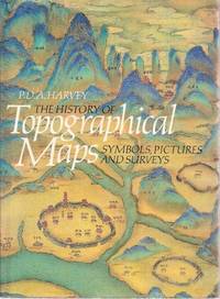
Harvey P. D. A
The History of Topographical Maps : Symbols Pictures and Surveys
New York: Thames & Hudson 1980. Fine condition in a Fine dust jacket price clipped. NO chips. NO tears. NO creases. NO fading. Bright shiny clean and square. Sharp corners. NO owner's name or bookplate. NO remainder mark. Crisp and unmarked. Illustrated with 116 maps 10 in color. Bound in the original gilt-stamped light blue cloth. Complete with dust jacket. 7.5" wide by 10.25" tall. Thrower p. 264: ". deals with many types of maps charts and views generally prior to the eighteenth century." KEYGUIDE No. 259: "Professor Harvey examines the development of topographical maps from the early attempt to communicate information by abstract symbols through picture maps to scale maps based on measured survey. An interesting well-illustrated text and thesis for historians of mapmaking cartographers designers geographers and map users generally.". First Edition. Hardcover. Fine condition/Fine jacket price clipped. 199pp. Great Packaging Fast Shipping. Thames & Hudson Hardcover
Bookseller reference : 018083 ISBN : 0500241058 9780500241059
|
|
|
Harvey PDA. P. D.
MAPS IN TUDOR ENGLAND
London: The Publice Record Office and The British Library 1993. 120pp. Ilustrated throughout with 81 plates. 1st edition. hard back. Fine/Fine. 4to. The Publice Record Office and The British Library hardcover
Bookseller reference : S270 ISBN : 0712303111 9780712303118
|
|
|
HARVEY (P. D. A.) & THORPE (Harry)
The Printed Maps of Warwickshire 1576-1900.
First edition, 4to, xii, 279pp., orig. cloth, d.w.
|
|
|
Harvey Miles
L'isola delle mappe perdute
trad. di Alex Ruggero in 16°, cartone edit. con sovrac. ill., sguardie illustrate

|
|
|
Hass Hans
Fra squali e coralli. Avventure nel Mar Caraibico [Curaçao, ANTILLE OLANDESI]
illustrazioni

|
|
|
Hayes, Derek
British Columbia - A New Historical Atlas
368 pages. Index. Bibliography. "Award-winning map historian Derek Hayes continues his renowned Historical Atlas series by bringing together an unprecedented collection of these contemporary maps, most previously unpublished, in a single handsome volume. You'll find surveys, treaty maps, military maps, mining maps, promotional maps, real estate maps - even maps of murder. Alongside the lively and authoritative text and an additional three hundred photos and historical documents, these maps, many of them works of art in their own right, offer a geographical visual history - a unique and fascinating view of the province's past." - dust jacket. Clean, bright and unmarked with negligible wear. Dust jacket preserved in archival-grade Brodart. An excellent copy of this large and magnificent work. 35 x 26cm. Book

|
|
|
Hayes, Derek
Historical Atlas of British Columbia and the Pacific Northwest : Maps of Exploration - British Columbia, Washington, Oregon, Alaska and Yukon
208 pages. Index. Footnotes. "A unique collection of over 320 original maps of explorers and navigators from four centuries of voyages and overland treks of exploration and discovery to the northwest coast, plus native maps, and a host of others selected for their interest and historical significance." - dust jacket. Clean, bright and unmarked with very light wear. An excellent example of this wonderful work. Book

|
|
|
HAYES-McCOY (G. A.) Editor.
Ulster and other Irish Maps c. 1600.
First edition, folio, xv, [1], 36pp., 21 plates (some coloured, some folding), orig. green cloth, gilt. 23 Early Irish manuscript maps are illustrated and fully described in scholarly essays.
|
|
|
Hedin,Anders.
Sveriges sjökartor: 1539 - 1836. Seacharts of Sweden.
<br/> STATO: NUOVO.<br/> TITOLO: Sveriges sjökartor:1539-1836. Seacharts of Sweden. <br/> AUTORE: Hedin,Anders.<br/> CURATORE: Translation by Kim Loughran.<br/> EDITORE: Bokforlaget Max Strom<br/> DATA ED.: 2008,<br/> COLLANA: text in English and Swedish.<br/> EAN: 9789171260550

|
|
|
HEDINGER Barbel
Karten in Bildern. Zur Ikonographie der Wandkarte in holländischen Interieurgemälden des 17. Jahrhunderts
Hildesheim, Olms 1986 349pp.with 147 bl/w ills., 21cm., softcover, very good, S85370
Bookseller reference : S85370
|
|
|
HEDINGER Barbel
Karten in Bildern. Zur Ikonographie der Wandkarte in holländischen Interieurgemälden des 17. Jahrhunderts
349pp.with 147 bl/w ills., 21cm., softcover, very good, S85370
|
|
|
 Receive by email
 Download as PDF document
 RSS feed


