|
Hodgkiss A. G.; & A. F. Tatham
Keyguide to Information Sources in Cartography
London: Mansell Publishing Limited 1986. Fine condition. Bright shiny clean square. Sharp corners. NOT a library discard. Hinges are perfect. NO owner's name or bookplate. NOT a remainder. Pages are crisp and unmarked. 1986. First U. K. Edition. This valuable annotated guide describes 796 works on maps and mapmaking. Among them are works about map history discovery and exploration map dating and identification carto-bibliographies contemporary cartography etc. Also listed are 600 major map collections mapping agencies publishers associations and societies. In addition there are sections with advice on cataloguing maps storage conservation etc. Bound in the original green boards stamped in white and black. First U. K. Edition. Hardcover. Fine condition/No jacket as issued. 8vo. x 253pp. Great Packaging Fast Shipping. Mansell Publishing Limited Hardcover
Bookseller reference : 019093 ISBN : 0816014035 9780816014033

|
|
|
Hodgkiss A. G.; & A. F. Tatham
Keyguide to Information Sources in Cartography
New York: Facts on File Publications 1986. Very Good condition. NOT a library discard. Hinges are perfect. NO owner's name or bookplate. Pages are clean crisp and unmarked. 1986. First U. S. Edition. This valuable annotated guide describes 796 works on maps and mapmaking. Among them are works about map history discovery and exploration map dating and identification carto-bibliographies contemporary cartography etc. Also listed are 600 major map collections mapping agencies publishers associations and societies. In addition there are sections with advice on cataloguing maps storage conservation etc. Bound in the original green boards stamped in white and black. First U. S. Edition. Hardcover. Very Good condition/No jacket as issued. 8vo. x 253pp. Great Packaging Fast Shipping. Facts on File Publications Hardcover
Bookseller reference : 019092 ISBN : 0816014035 9780816014033
|
|
|
HODSON D.
Portsmouth Record Series. Maps of Portsmouth before 1801. A Catalogue. NEAR FINE COPY IN DUSTWRAPPER
Folio, First Edition, with frontispiece, maps and endpaper maps; black cloth, gilt back, a near fine copy in dustwrapper.

|
|
|
HODSON Y.
Popular Maps. The Ordnance Survey Popular Edition One-Inch Map of England and Wales 1919-1926.
8vo., First Edition, with 13 coloured plates and 46 illustrations in the text; laminated boards, a near fine copy in unclipped dustwrapper. Includes a full catalogue of all known printings of the 146 sheets of the map
|
|
|
Hoffmann, Detlef und Margot Dietrich:
Gemalte Spielkarten. Deutsches Spielkarten-Museum Leinfelden-Echterdingen,
, _Deutsches Spielkarten-Museum, 1985, softcover 50 pag Illustrated.
Bookseller reference : 62433
|
|
|
Hoffmann, F
Fortschritte d. Kartographie 1969-1982. (Sammelbd. ausgew. Referate v. Veröffentlichungen u. Buchrezensionen). Studienhilfsmittel.
Dresden, 1982. 159 S. St. a. Tit. (TU Dresden, Sekt. Geodäsie u. Kartogr.).
Bookseller reference : 621954
|
|
|
HOFMANN Catherine - LECOQ Danielle -
Lo globe et son image.
Paris, Bibliotheque Nationale de France, 1995, 8vo album brossura con copertina illustrata, pp. 75 con numerose illustrazioni in nero e a colori nel testo.

|
|
|
HOGE E.
Nouvelle contribution à la carte magnétique de la Belgique
50pp.avec figures dans le texte + grande carte dépliante en couleur, 29cm., dans la série "Académie royale de Belgique, classe des sciences, mémoires, collection in-4o, deuxième série" tome 11 fascicule 1, br.orig., non coupé, bon état
|
|
|
HOGE E.
Nouvelle contribution à la carte magnétique de la Belgique
Bruxelles, Palais des Académies 1934 50pp.avec figures dans le texte + grande carte dépliante en couleur, 29cm., dans la série "Académie royale de Belgique, classe des sciences, mémoires, collection in-4o, deuxième série" tome 11 fascicule 1, br.orig., non coupé, bon état
Bookseller reference : B66753
|
|
|
Hogenberg Franz; Braun George
Pianta prospettica di Venezia a volo d'uccello: VENETIA
Incisione in rame (337 x 482) mm, a pieni margini. Foglio (42 x 54) cm. Stato unico. Prima edizione. Esemplare in ottime condizioni, salvo poche segni di ossidazione. In alto al centro della veduta "VENETIA". Molti nomi di località ed isole nell'inciso. In basso elenco, disposto in sette colonne, delle località segnalate nella carta con numeri progressivi da I a XXXV e da 1 a 153. Al centro, dopo la quarta colonna, dentro un cartiglio vignetta rappresentante il corteo ducale durante la festa del Corpus Domini, con sotto breve descrizione dell'evento e sopra ad ogni personaggio della carica ricoperta. Proveniente da "Civitates orbis terrarum", stampato per la prima volta nel 1572, poi ristampato numerose volte in latino, tedesco e francese fino al 1623. L'edizione del 1572 è l'unica che non ha le tavole numerate. Cassini N° 18; Moretto N° 26. Schultz N° 42; Romanelli Biadene N° 13.

|
|
|
HOLDSWORTH MAY, COURTAUD CAROLINE, HU CHUI
The forbidden city, the great within .
1995 Odyssey 1995, 136 pages, in 4 oblong reliure cartonnée toilée ocre avec jaquette bon état .
Bookseller reference : 14408
|
|
|
HOLLANDER Raymond de
"Topographie générale (2 volumes); tome 1 : généralités, mesures des angles et distances; tome 2 : Les procédés topographiques en planimétrie et nivellement. Collection scientifique de l'Institut géographique national."
Paris, Editions Eyrolles, 1970-1971. 16 x 25, 2 volumes, 363 + 432 pages, nombreuses figures, 1 planche dépliante, reliure d'édition pleine toile, très bon état (sauf cachet d'ex-propriétaire).
Bookseller reference : 90912
|
|
|
HOLLANDER Raymond de, et autres
Loxodromie et projection de Mercator.
Paris/Monaco, Institut Océanographique, 2005. 25 x 31, 240 pp., nombreuses figures en couleurs et en N/B, reliure d'édition carton imprimé, très bon état (sauf 1 cachet d'ex-propriétaire).
Bookseller reference : 90577
|
|
|
Holmden, H.R.
Catalogue des cartes, plans et cartes marines conservés au dépôt des cartes des Archives canadiennes
Imprimerie nationale Fort in-8 Couverture souple Ottawa 1912
Bookseller reference : 3126
|
|
|
HOMANN
La Suisse divisée en ses tréze cantons, ses alliez et ses sujets. Helvetia tredecim statibus liberis quos cantones vocant composita.
Norimbergae, Homannianis heredibus, 1751. (mm. 450 x 560). Carta geografica della Svizzera con lieve coloritura dei confini, che illustra anche parte della Lombardia, Piemonte e Veneto.

|
|
|
HOMANN (EREDI).
Charte von America nach Astronomischen Bestimmungen, den neuesten Nachrichten und Charten entworfen von F. L. Güssefeld. Nürnberg bey Homann Erben.
Norimberga, 1796. Incisione in rame all’acquaforte, colore d’epoca, cm 45 x 58 (la parte incisa), in basso a sn., in lastra, “I. Rausch Sc.”, titolo in basso a sn. entro tondo. Si tratta di una rara mappa dell'America, di grande formato, con dettagli interessanti specie nel tratto del Passaggio a Nord Ovest, basati sulle informazioni derivate da Vancouver, La Perouse, Cook, Mac Kenzie e dagli altri esploratori contemporanei; Quivira e Neu Albion compaiono a ovest; si notano le isole Sandwich (isole hawaiane). La presenza del fiume Oregon che scorre dall'area a ovest del Mississippi fino all'Oceano Pacifico è una delle ultime comparse di questo fiume su una mappa. Rifilati il margine superiore e l’inferiore grossomodo in prossimità della battuta della lastra, alcuni leggeri aloni di umido sulla parte sinistra, bella coloritura, buono stato di conservazione di tutto l’inciso. .

|
|
|
Homann Erben ? Penther, Johann Friedrich
Comitatus Stolbergici ad Hercyniam ceterarumq[ue] ad Illustriss. Comites pertinentium Ditionum & terrarum ipsis adjacentium Georgraphica Descriptio. Gezeichnet 22. Oct. 1736 von J. F. Penther. [Altkolorierter Kupferstich, gerahmt / handcolored copper engraving, framed].
o.J. [3 Warenabbildungen] Johann Baptist Homann, geboren 1664, gestorben 1724, gründete sein Geschäft 1702 in Nürnberg. Sein Kartenverlag wurde zu
Bookseller reference : 13825DB

|
|
|
HOMANN JEAN BAPTISTE
PLAN DE LA PLACE DE CORFOU AVEC SES ENVIRONS ASSIEGEE
HOMANN JEAN BAPTISTE PLAN DE LA PLACE DE CORFOU AVEC SES ENVIRONS ASSIEGEE. , 1716, Tracce di acquerellatura. Mediocre (Poor) Discreto es. - presenta buchi, gore e bruniture sparse. acquaforte <br> cm. 57 x 49 <br> <br> <br>

|
|
|
HOMANN JEAN BAPTISTE
PLAN DU SIEGE DE CORFOU
HOMANN JEAN BAPTISTE PLAN DU SIEGE DE CORFOU. , 1716, Acquerellata in epoca. Mediocre (Poor) Es. problematico. acquaforte <br> cm. 57 x 49 <br> <br> <br>

|
|
|
HOMANN Y. B. (1664 - 1724)
TABULA DUCATUS CARNIOLIAE VINDORUM MARCHIAE ET HISTRIAE
HOMANN Y. B. (1664 - 1724) TABULA DUCATUS CARNIOLIAE VINDORUM MARCHIAE ET HISTRIAE. , 1720, Buono (Good) Buon es., tracce leggere di foxing e piccolo restauro d'epoca al margine basso. acquaforte acquerellata a mano <br> inciso cm. 58 x 49 <br> <br> <br>
|
|
|
HOMANN, IO. BAPTISTA.
Imperium Turcicum in Europa, Asia et Africa Regiones.
Norimberga, 1737. Incisione in rame all'acquaforte, coeva coloritura a mano, cm 51 x 61 circa (il foglio) più margini. Ricco cartiglio in basso a sinistra, con figure di schiavi, mendicanti, santi, studiosi e guerrieri. Esemplare rifilato ai margini superiore e inferiore, sciupature agli estremi della brachetta (visibile al superiore), bella e vivace coloritura, nell'insieme buono stato di conservazione. .

|
|
|
HOMANN, IOH. BAPT.
Regnorum Siciliae et Sardinae nec non Melitae seu Maltae Insula cum adjectis. Italiae et Africae Litoribus Nova Tabula.
Norimberga, 1760 circa. Incisione in rame all'acquaforte, colore d'epoca, cm 51 x 58 (il foglio). In alto al centro, importante cartiglio; in basso a sinistra, in riquadro, “Catanae urbis eiuque vicini Montis Aetnae in Sicilia Prospectus”; in basso a destra, in piccolo riquadro “Valletta civitas Maltae celeberrima...”. Tranne il superiore, margini rifilati in prossimità del perimetro graduato, brachetta centrale leggermente ingiallita dalla metà inferiore del foglio, peraltro buon esemplare in bella coloritura. .

|
|
|
HOMANN, IOH. BAPT.
Regnorum Siciliae et Sardinae nec non Melitae seu Maltae Insula cum adjectis. Italiae et Africae Litoribus Nova Tabula.
Norimberga, 1760 circa. Incisione in rame all'acquaforte, colore d'epoca, cm 51 x 58 (il foglio). In alto al centro, importante cartiglio; in basso a sinistra, in riquadro, “Catanae urbis eiuque vicini Montis Aetnae in Sicilia Prospectus”; in basso a destra, in piccolo riquadro “Valletta civitas Maltae celeberrima...”. Margini con qualche difetto, un lieve foxing, bella coloritura, buono stato. .

|
|
|
Homann, Johann Baptist (1664?1724)
Planiglobii Terrestris cum utroq Hemisphaerio Caelesti generalis exhibito.
Nürnberg, J.B. Homann, ca. 1720. Altkolorierter Kupferstich. Bildformat: 56 x 65 cm. Blattformat: 51 x 60 cm. + Wichtig: Für unsere Kunden in der EU erfolgt der Versand alle 14 Tage verzollt ab Deutschland / Postbank-Konto in Deutschland vorhanden +, 973DG
Bookseller reference : 973DG

|
|
|
Homann, Johann Baptist (1664–1724).
Planiglobii Terrestris cum utroq Hemisphaerio Caelesti generalis exhibito.
Nürnberg, J.B. Homann, ca. 1720. Altkolorierter Kupferstich. Bildformat: 56 x 65 cm. Blattformat: 51 x 60 cm.
Bookseller reference : 973DG
|
|
|
HOMANN, Johann Baptist.
Status Parmensis sive Dvcatvs Parmensis et Placentinvs...
Carta geografica incisa in rame (cm. 49,5x 59) abilmente colorata da mano coeva.Grande carta con grande cartiglio alla base e con scena di caccia e le piante delle città di Parma e di Piacenza. Stampata dagli eredi di Homann e datata 1731. Nel 1702 J.B. Homann a Norimberga inizia l'attività di cartografo. Dopo la pubblicazione del primo atlante (1707) divenne membro dell'Accademia delle Scienze di Berlino, nel 1715 venne nominato Geografo dell'Imperatore. Nel 1724 data della sua morte, l'attività passa al figlio e successivamente trasmessa ai suoi eredi con il nome, appunto di Eredi Homann.. .

|
|
|
HOMANN, Johann Baptist.
Status Parmensis sive Dvcatvs Parmensis et Placentinvs...
Carta geografica incisa in rame (cm. 49,5x 59) abilmente colorata da mano coeva.Grande carta con grande cartiglio alla base e con scena di caccia e le piante delle città di Parma e di Piacenza. Stampata dagli eredi di Homann e datata 1731. Nel 1702 J.B. Homann a Norimberga inizia l'attività di cartografo. Dopo la pubblicazione del primo atlante (1707) divenne membro dell'Accademia delle Scienze di Berlino, nel 1715 venne nominato Geografo dell'Imperatore. Nel 1724 data della sua morte, l'attività passa al figlio e successivamente trasmessa ai suoi eredi con il nome, appunto di Eredi Homann.. .
|
|
|
Homann, Johannes Baptist
Provincia Indigenis dicta La Provence; divisa in omnes suos Vicariatus seu Praefecturas et Terras adiacentes eidem subiectas excudente Io. Baptista Homanno. [Altkolorierter Original-Kupferstich, gerahmt / original colored copper engraving, framed].
o.J. Johann Baptist Homann, geboren 20. März 1664 in Oberkammlach, gestorben 1. Juli 1724 in Nürnberg, Kartograph, Verleger und Kupferstecher. [3 Warenabbildungen]
Bookseller reference : 60148BB

|
|
|
Homann, Johannes Baptist
Recentitissima Asiae Delinatio qua Imperia ejus regna et Status, unacum novissimis Russorum detectionib circa Mare Caspium Terram Yedso... [Altkolorierter Kupferstich um 1720 / colored copper engraving].
o.J. Johann Baptist Homann, geboren 20. März 1664 in Oberkammlach, gestorben 1. Juli 1724 in Nürnberg, Kartograph, Verleger und Kupferstecher.
Bookseller reference : 49972BB

|
|
|
HOMANN, JOHANNES BAPTISTAE (HEREDI D'HOMANN).
Carta geographica, la quale rappresenta lo Stato della Republica di Genova partita nella Riviera di Levante et di Ponente.
Norimberga (o Augusta), 1743 circa. Incisione in rame, colore d’epoca, cm 50 x 59 (alla lastra). Esemplare leggermente rifilato nella parte destra del margine inferiore, in corrispondenza della battuta della lastra, ingiallimento della brachetta centrale al verso, impressione un po’ stanca, nell’insieme buono stato.

|
|
|
Homman Johann Baptist
Status ecclesiastici magnique Ducatus Fiorentini. Nova Exibitio repraesentatio a Io. Bapt. Hommano. Norimbergae, Cum privilegio Sac. Caes. Majestatis.
In folio grande (56,5x48 cm); un rinforzo moderno in adesivo (assolutamente non visibile al verso con l'immagine della Toscana, in corrispondenza della piega del foglio. Un piccolo strappetto, di 6 cm circa, senza perdita di carta e ora chiuso, al margine basso, in corrispondenza della piega del foglio, ininfluente e per il resto, in buone condizioni di conservazione. Fine coloritura coeva a mano. Magnifica e dettagliata carta del centro Italia, dai possedimenti del Ducato Estense fino alla periferia romana, con i possedimenti dello Stato Pontificio nel territorio toscano. La tavola è opera di Johann Baptist Homann celeberrimo cartografo ed incisore tedesco, nato a Norimberga nel 1663. Homman iniziò l'attività di cartografo, come apprendista, nella bottega di David Funk prima e per Giacomo Sandrart, dove apprese l'arte. Nel 1702, decise di aprire una nuova attività in proprio di produzione di carte geografiche. L'estrema cura geografica e l'innovativa veste grafica gli fece ottenere, velocemente, un enorme successo ed una notevole fama, tanto da divenire, ben presto, uno dei cartografi più di successo del XVIII° secolo. Nel 1707 pubblica la propria opera più importante, il “Grosser Atlas” che nella sua massima estensione, fu composto di 126 carte. Esemplare in buone condizioni di conservazione.

|
|
|
HONDIUS, JODOCUS.
Nova Italiae Delineatio.
Amsterdam, 1620 circa. Incisione in rame all'acquaforte, colore, cm 39 x 50, 8 (alla lastra) più margini bianchi. Titolo in alto a destra, entro cartiglio costituito da tavola sorretta da figure allegoriche con sottostante la “Lupa Italia” che allatta Romolo e Remo; in basso a destra, entro altro cartiglio con i busti di Romolo e Remo, due scale grafiche di miglia italiane e germaniche; nel mare ci sono navi e vascelli e la testa emergente di un mostro marino. Carta con reticolato e con margine graduato su tutto il perimetro. Testo francese al verso. Tutti gli elementi della carta derivano dalla “Italia Nuova” del Magini del 1608. La carta conobbe molte ristampe, tra cui quelle realizzate da J. Jansonium e inserite nei più diffusi atlanti olandesi della prima metà del 1600, tra cui quello dei Blaew; tra queste se ne segnala una datata 1641, con scale grafiche in basso a sinistra e con l'inserimento, in basso a destra, di otto stemmi degli stati più importanti. La carta è peraltro identica a quella fiancheggiata complessivamente da dodici vedute di città, da otto riquadri con costumi italiani e da otto stemmi che la rendono ricca di sfarzo e molto decorativa. Esemplare in bella coloritura e in margini, molto buono lo stato di conservazione.

|
|
|
HONGXUN WANG
Chinese kites: traditionnal chinese art and culture.
1989 Foreign languages press Beijing, 1989, nombreuses photographies et 18 pages de textes soit 60 pages environ bon état.
Bookseller reference : 13165
|
|
|
Hosam Elkhadem, J.P. Heerbrandt, L. Wellens-de Donder
Kaarten van Amerika in de verzamelingen van de Koninklijke Bibliotheek Albert I
Paperback, 168 pagina's, Nederlands, 255 x 185 mm, boek in prima staat, . ISBN 9789066370753. Beschrijving van 59 kaarten van Amerika

|
|
|
Hosam Elkhadem, J.P. Heerbrandt, L. Wellens-de Donder
Kaarten van Amerika in de verzamelingen van de Koninklijke Bibliotheek Albert I
, Kon. Bibliotheek Albert I /KB 1992, 1992 Paperback, 168 pagina's, Nederlands, 255 x 185 mm, boek in prima staat, . ISBN 9789066370753.
Bookseller reference : 56762
|
|
|
Hoskins, Samuel A. (Publisher)
Map of Sioux City, Iowa, 1881
Samuel A. Hoskins, Bookseller & Stationoer, Sioux City - Stranahan & Taylor, Cleveland, 1881.
Bookseller reference : 116847

|
|
|
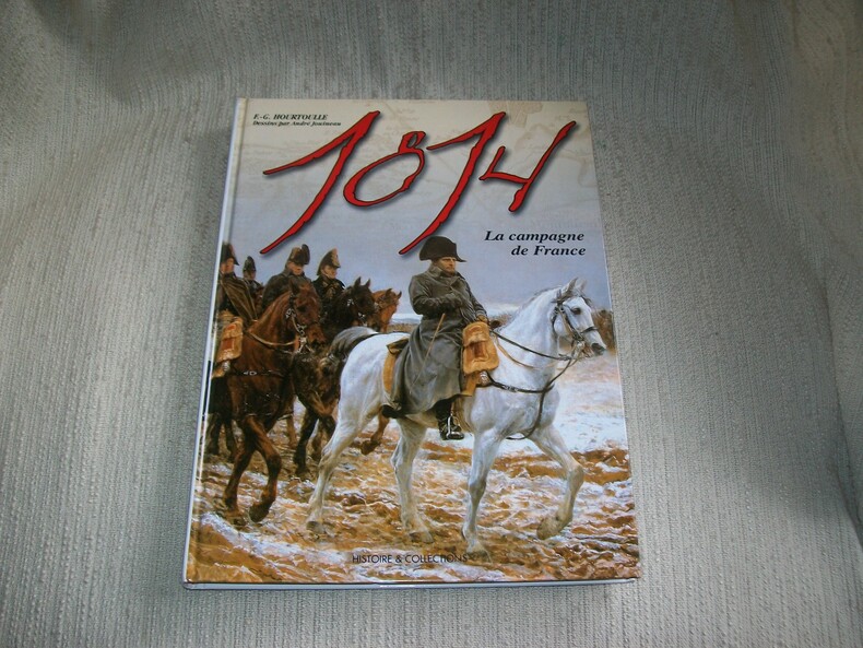
HOURTOULLE
1814 LA CAMPAGNE DE FRANCE l'Aigle blessé.
Paris Histoire et Collections 2005. In-4 176pp imprimées sur 2 colonnes. Cartonnage éditeur papier glacé bradel illustré en couleurs. Abondante et belle illustration d'après des documents anciens, en noir et en couleurs, planches d'uniformologie par André Jouineau, cartographie par Jean-Marie Mongin et Denis Gandilhon. Bel exemplaire frais et complet. Excellente documentation, très bien illustrée.
Bookseller reference : GITj302
|
|
|
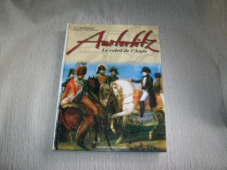
HOURTOULLE
AUSTERLITZ le soleil de l'Aigle.
Paris Histoire et Collections 2003. In-4 128pp imprimées sur 2 colonnes. Cartonnage éditeur papier glacé bradel illustré en couleurs. Abondante et belle illustration d'après des documents anciens, en noir et en couleurs, planches d'uniformologie par André Jouineau, cartographie de Jean-Marie Mongin. Bel exemplaire frais et complet. Excellente documentation, très bien illustrée.
Bookseller reference : GITj305
|
|
|
HOURTOULLE
BORODINO LA MOSKOWA. La bataille des redoutes.
Paris Histoire et Collections 2000. In-4 120pp imprimées sur 2 colonnes. Cartonnage éditeur papier glacé bradel illustré en couleurs. Abondante et belle illustration d'après des documents anciens, en noir et en couleurs, planches d'uniformologie par André Jouineau, cartographie de Morgan Gillard. Bel exemplaire frais et complet. Excellente documentation, très bien illustrée.
Bookseller reference : GITj301

|
|
|
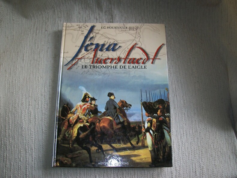
HOURTOULLE
IENA AUERSTAEDT le triomphe de l'Aigle.
Paris Histoire et Collections 1998. In-4 120pp imprimées sur 2 colonnes. cartonnage éditeur papier glacé bradel illustré en couleurs. Abondante et belle illustration d'après des documents anciens, en noir et en couleurs, planches d'uniformologie par André Jouineau, cartographie de Morgan Gillard. Bel exemplaire frais et complet. Excellente documentation, très bien illustrée.
Bookseller reference : GITj303
|
|
|
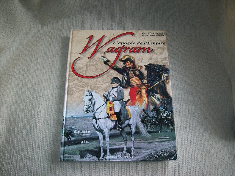
HOURTOULLE
WAGRAM. L'apogée de l'Empire.
Paris Histoire et Collections 2002 In-4 120pp imprimées sur 2 colonnes. Cartonnage éditeur papier glacé bradel illustré en couleurs. Abondante et belle illustration d'après des documents anciens, en noir et en couleurs, planches d'uniformologie par André Jouineau, cartographie de Jean-Marie Mongin. Bel exemplaire frais et complet. Excellente documentation, très bien illustrée.
Bookseller reference : GITj304
|
|
|
HOUTMAN Erik
Een kaartboek van de sint-Bernardsabdij Hemiksem 1666-1671
322pp.rijkelijk geïllustreerd met kaarten en plannen in kleur, linnen uitgeversband, geïllustreerde stofwikkel, 34cm., mooie staat, in de reeks "Cartografische en iconografische bronnen voor de geschiedenis van het landschap in België" volume IX, BIJGEVOEGD: CD-ROM "Landboeken van de Sint-Bernarsabdij te Hemiksem 1744-1752", B89621
|
|
|
HOUTMAN Erik
Een kaartboek van de sint-Bernardsabdij Hemiksem 1666-1671
322pp. rijkelijk geïllustreerd met kaarten en plannen in kleur, linnen uitgeversband, geïllustreerde stofwikkel, 34cm., goede staat, in de reeks "Cartografische en iconografische bronnen voor de geschiedenis van het landschap in België" volume IX, B108483
|
|
|
HOUTMAN Erik
Een kaartboek van de sint-Bernardsabdij Hemiksem 1666-1671
Brussel, ARA 2005 322pp.rijkelijk geïllustreerd met kaarten en plannen in kleur, linnen uitgeversband, geïllustreerde stofwikkel, 34cm., mooie staat, in de reeks "Cartografische en iconografische bronnen voor de geschiedenis van het landschap in België" volume IX, BIJGEVOEGD: CD-ROM "Landboeken van de Sint-Bernarsabdij te Hemiksem 1744-1752", B89621
Bookseller reference : B89621
|
|
|
HOUTMAN Erik
Een kaartboek van de sint-Bernardsabdij Hemiksem 1666-1671
Brussel, ARA 2005 322pp. rijkelijk geïllustreerd met kaarten en plannen in kleur, linnen uitgeversband, geïllustreerde stofwikkel, 34cm., goede staat, in de reeks "Cartografische en iconografische bronnen voor de geschiedenis van het landschap in België" volume IX, gewicht: 2.8kg., B108483
Bookseller reference : B108483
|
|
|
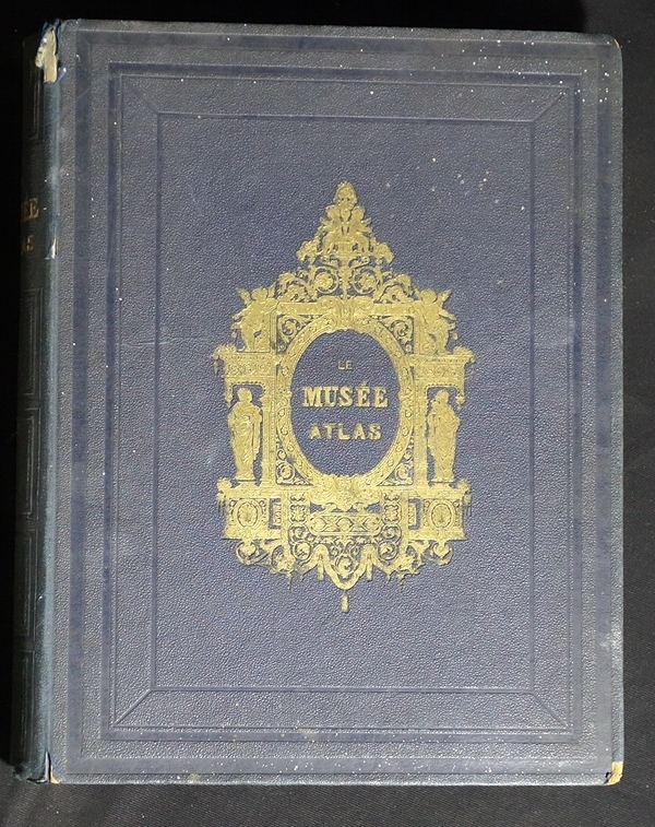
HOUZE A.
Le Musée-Atlas universel historique et géographique, donnant les divisions et modifications territoriales des diverses nations aux principales époques de leur histoire, notices indiquant tous les faits importants, leur date et les lieux où ils se sont passés
LEBIGRE-DUQUESNE Frères éditeurs, Paris
Bookseller reference : 324
|
|
|
Hueber, Blasius
Provincia Arlbergica.
Wien, Johann Ernst Mansfeld, 1783. Kupferstichkarte, gestochen von Johann Anton Pfaundler. 115 x 66 cm. + Wichtig: Für unsere Kunden in der EU erfolgt der Versand alle 14 Tage verzollt ab Deutschland / Postbank-Konto in Deutschland vorhanden +, A
Bookseller reference : 1804AG

|
|
|
Hughes William
PHILIPS HANDY CLASSICAL ATLAS
London: George Philip and Son 32 Fleet Street 18 colour printed double page maps. ND. Attractive late Victorian blind-embossed decorated brown buckram covers with original pale yellow end-papers. Title-apge a trifle foxed. Hardback. V.g. small 4to. George Philip and Son, 32 Fleet Street Hardcover
Bookseller reference : Le593
|
|
|
Hughes William
PHILIPS' SELECT ATLAS OF MODERN GEOGRAPHY
London: George Philip and Son 1874. constructed from the Latest & Most Authentic Sources with a copious consulting Index.24 double-page colour maps. 35 pp index. Fine pebble-grain green cloth boards with gilt titles. Blind decoration. Printed catalogue list to the end-papers. . 1st Edition. Hardback. Fine. 4to. George Philip and Son Hardcover
Bookseller reference : GT217
|
|
|
Hugues Luigi
NUOVO ATLANTE GEOGRAFICO AD USO DELLE SCUOLE SECONDARIE SUPERIORI. Nuovissima edizione di 45 carte con repertorio di tutti i nomi.
(Codice OS/0280) In 8° (27,5x21 cm) 26 pp. (indice) + 45 doppie carte a colori, alcune ripiegate. Piccola firma. Mezza tela d'epoca piuttosto consunta ma ancora solida, interno buono. ~~~ SPEDIZIONE IN ITALIA SEMPRE TRACCIATA

|
|
 Receive by email
 Download as PDF document
 RSS feed


