|
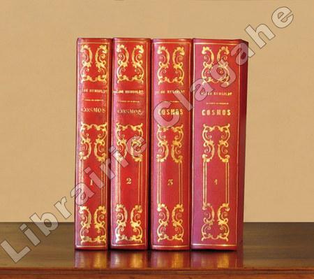
Humboldt, Alexandre de :
Cosmos essai d'une description physique du monde. Traduit par F. Faye (Tomes 1 et 3), puis par Ch. Galusky (T. 2 et 4).
Paris, Gide et Cie, puis Gide et J. Baudry, enfin Gide, 1847 - 1859 ; 5 tomes reliés en quatre volumes, in-8 ; demi-chagrin rouge, dos lisses à grands décors de rinceaux, volutes et filets dorés, titre doré (reliure de l'époque) ; (4), VII, (1 bl.), VIII, 580 pp. ; XIV, (2), 636 pp. ; VIII, (2), 363 pp., (1 bl.) ; VI, (2) pp. 365 - 763 ; VII, (1), 806 pp., (1) f. bl., 4 pp. de catalogue.
Bookseller reference : 9410
|
|
|
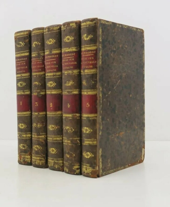
HUMBOLDT , Alexandre de
Essai politique sur le royaume de la Nouvelle-Espagne.
Paris, F. Schoell, 1811 ; 5 vol. in-8, relié veau raciné, dos lisse orné, pièces de titre et de tomaison rouge, tranches marbrées, illustré d’un plan dépliant et d’une grande carte par Poirson. Édition originale au format in-octavo, conforme à celle in-4 de 1811, 2ff-iii-456, 2ff-520pp-1ff, 2ff-419pp ,2ff-564pp-1ff . Rongés avec manques de cuir, épidermures, intérieur frais.
Bookseller reference : PHO-1656
|
|
|
Humphreys AL. A. L.
ANTIQUE MAPS AND CHARTS
London: Bracken Books 1989. 191pp. Colour plates throughout. 94 illus. 32 colour. This is a new edition of " Old Decorative Maps and Charts " that was published by Halton & Truscott Smith in 1926 and is based on the collection of A G H Macpherson. Small closed tear to the otherwise fine d.j. Scrawling owners inscription to the inside end-paper. re-issue. Hardback. Fine/V.g. large 4to. Bracken Books Hardcover
Bookseller reference : MW193 ISBN : 1851702563 9781851702565
|
|
|
Hyams Edward.
TERRE E CIVILTA'.
(Codice AK/0105) In 8° (20,5 cm) 399 pp. Indagine sulle reciproche influenze tra culture e territorio. Prima edizione italiana illustrata con 3 tavole a colori (una grande ripiegata), 54 foto e 5 carte geografiche. Cartone editoriale, taglio superiore colorato, sovraccoperta. COME NUOVO. ~~~ SPEDIZIONE IN ITALIA SEMPRE TRACCIATA

|
|
|
Hyde Ralph
Map Collectors' Circle Series Fourth Volume Vol. IV No. 38 : Ward Maps of the City of London
London: Map Collectors' Circle 1967. Complete with errata slip laid-in. Fine condition. Clean and unmarked. NOT a library discard. NO owner's name or bookplate. Describes maps from 1720 to 1905. 75 main entries plus variants. Illustrated with 16 plates. Bound in the original tan wraps printed in black. 7.25" wide by 9.75" tall. First Edition. Softcover. Fine condition. 56pp. Great Packaging Fast Shipping. Map Collectors' Circle Paperback
Bookseller reference : 018899
|
|
|
Hymans, Louis
Bruxelles a travers les ages : dedie avec la gracieuse autorisation de ll. aa. rr. M. le comte et M. la comtesse de Flandre a son altesse royale M. le prince Baudouin
In folio, cm 34, due volumi di pp. 484 e pp. 466. Splendide legature editoriali in tela blu, illustrate in nero con titoli in oro al piatto e al dorso, tagli esterni dorati. Il volume primo con parziale fenditura della cerniera, comunque solido. Ottimo stato di conservazione complessivo di entrambi i volumi (fisiologiche fioriture alle prime e ultime carte bianche). Opera riccamente illustrata da centinaia di incisioni nel testo e fuori testo, anche a doppia pagina, alcune a colori o ripiegate. Un terzo volume pubblicato qualche anno più tardi chiuderebbe idealmente l'opera, comunque tematicamente completa in quanto il titolo dell'ultimo volume è differente: Bruxelles Moderne.

|
|
|
Hérisson
Carte de l'Empire Ottoman, théâtre de la guerre en Europe et en Asie, dressée par Hérisson, 1854
J. Noël et Fourmage, éditeurs Carte 1854 Carte ancienne (env. 87 x 63 cm dépliée), de l'Empire Ottoman, théâtre de la guerre en Europe et en Asie, dressée par Hérisson, comprenant un plan de Constantinople, de Chouma et ses environs, de Varna et de Silistrie, ainsi que de magnifiques ornements aquarellés (drapeaux), 2e édition, 1854 ; un petit défaut dans la marge gauche, par ailleurs très bel exemplaire. Livraison a domicile (La Poste) ou en Mondial Relay sur simple demande.
Bookseller reference : yd1551

|
|
|
I QUATTRO NOVELLI STATI MERIDIONALI AMERICANI ..
Carta incisa in rame e acquarellata a mano.
Carta di cm 36 x 50 alla battuta, più i margini, su tav. piegata a metà. Gli Stati citati nel titolo sono: 'CONFEDERAZIONE DEL CHILI, STATI UNITI SUL RIO PLATA, DITTATORATO DEL PARAGUAI, REPUBBLICA ORIENTALE DELL'URAGUAI'. Testo descrittivo su tre lati. Tratta da 'Atlante storico, geografico, genealogico, cronologico e letterario di M. A. Le Sage in ogni sua parte corretto, ampliato e proseguito sino all'anno corrente. Prima Veneta Edizione'.
|
|
|
I. A. (IBRAHIM ALAETTIN GÖVSA), (1889-1949).
[PROPAGANDA MAP SPREADING THE WORD THAT TURKEY IS WINNING THE WAR] Map of West Anatolia and the Archipelago showing the fronts of Turkish War of Independence in 1921-22. Tercümân-i Hakîkât'in kârilerine hediyesi. [i.e. Extra suppl. to 'Tercümân-i Hakîkat' Newspaper].
Very Good Turkish, Ottoman (1500-1928) An extremely rare litho propaganda map published as an extra supplement to the Tercümân-i Hakîkat [i.e. The Translator of Truth] newspaper just before the proclamation of Republic in Turkey in 1923 by Mustafa Kemal Atatürk (1881-1938), showing the front in West Anatolia during the War of Independence (or National Struggle) between 1919-1922 against Greek forces. The upside of the map between the note as title 'Gift to the readers of 'Tercümân-i Hakîkat', Mustafa Kemal Atatürk's portrait among decorated heroic lithographed drawings. In the lower right corner, can be seen legends of the map, scale, and mapmaker's signature. Tercümân-i Hakîkat was a daily newspaper published in Istanbul between 1878-1921 during the Ottoman Empire. Tercüman-i Hakîkat, the most important newspaper published during the reign of Sultan Abdülhamid II, was founded by novelist Ahmed Midhat Efendi, (1844-1912). In the beginning, most of the articles were written by Ahmed Midhat Efendi. It was an encyclopedic newspaper with the aim of inculcating and educating reading habits among the Turks and it played an important role in the training of many famous Ottoman journalists. Its first issue was published on June 26, 1878. After Ahmed Midhat's death in 1913, the newspaper changed owners, and the last issue was published on February 11, 1921. Ibrahim Alaettin Gövsa, (1889-1949), was an Ottoman / Turkish journalist, educator, and intellectual who supported the War of Independence the most. This propaganda map published in Tercümân-i Hakîkat, during the war in 1920 or 1921, is a propaganda tool that calls on the literate people belonging to a certain class, especially those living in Istanbul, to support the war, and aims to spread the word that Turkey is winning the war. Original lithograph map. 50x35,5 cm. In Ottoman script (Turkish with Arabic letters). Scale: 1: 250.000. Occasionally foxing and slight stains on paper, folded traces. Otherwise a very good copy.
|
|
|
Iachello, Enrico.
L’Ile aux trois pointes. Cartes de la Sicile de la collection La Gumina.
Sans lieu, Regione Siciliana 2001, 230x220mm, 189pages, broché. Bel exemplaire.
Bookseller reference : 110524

|
|
|
IBANEZ Général, PERRIER Colonel (sous la direction de).
Jonction géodésique et astronomique de l'Algérie avec l'Espagne, exécutée en commun en 1879, par ordre des gouvernements d'Espagne et de France,
Paris, Imprimerie Nationale, 1886, in-4 (266 x 213 mm.), page de titre, XIX-281 pp.,1 carte n/b, 7 planches doubles, 2 planches, 1 pl. double couleurs, reliure demi-basane, dos lisse, dos gratté en tête (cachet ou étiquette supprimé), épidermures et début de fente au mors (20 mm.), traces de colle sur contre plats, défaut page de titre : certainement un cachet de bibliothèque supprimé en grattant (petit manque et papier plus fin) et angle découpé (45 x 55 mm.) et restauré, restauration au feuillet 2 : 60 x 45 mm., bel état intérieur, bel exemplaire.
Bookseller reference : 4070

|
|
|
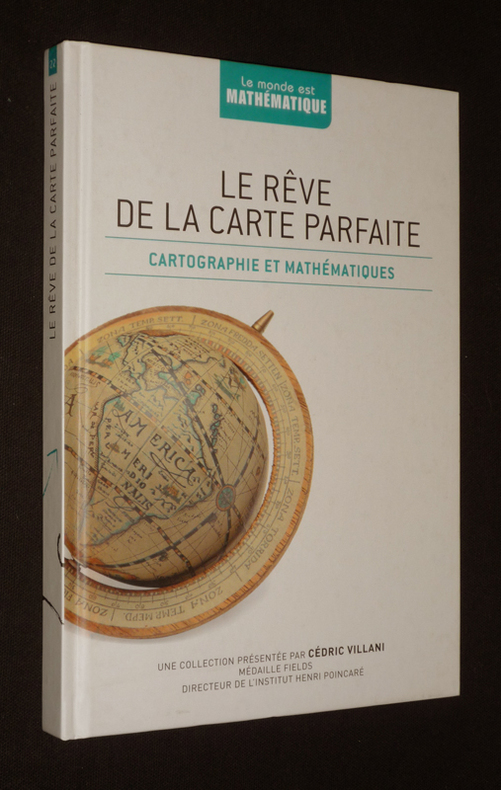
IBANEZ, R.
Le Rêve de la carte parfaite : Cartographie et mathématiques.
RBA Coleccionables ("Le Monde est Mathématique"), 2012. in-8, 175 pages, illustrations en noir, cartonnage illustré.
Bookseller reference : 74868
|
|
|
Ibanez Raul
Le Rêve de la carte parfaite : cartographie et mathématiques
RBA Le monde est mathématique Cartonné 2013 "In-8 (16,5 x 23,5 cm), cartonné, 177 pages, n°22 de la collection ""Le monde est mathématique"" ; très bon état. Livraison a domicile (La Poste) ou en Mondial Relay sur simple demande."
Bookseller reference : vh157
|
|
|
IBANEZ, R.
Le Rêve de la carte parfaite : Cartographie et mathématiques.
in-8, 175 pages, illustrations en noir, cartonnage illustré. Tres bel exemplaire. [AR-2]
|
|
|
IBRAHIM HILMI [ÇIGIRAÇAN], (1876-1963).; DOKTOR MORITMA (?).
[OTTOMAN MAP of BYZANTINE CONSTANTINOPLE] Kurun-u vustâ inhâsinda Kostantiniyye. Doktor Moritma'nin tetkikâtina göre kable'l-feth-i sehrin plâni. Feth-i Kostantiniyye asârina aiddir. Published by Ibrahim Hilmi.
Very Good Turkish, Ottoman (1500-1928) Original b/w city map of Byzantine Constantinople printed in ??? by Tüccarzâde Ibrahim Hilmi Çigiraçan, (1876-1963). Oblong: 37x50 cm. In Ottoman script. Folded. Scale is not described. Toponyms are Turkish besides some of old Byzantine. [OTTOMAN MAP of BYZANTINE CONSTANTINOPLE] Kurun-u vustâ inhâsinda Kostantiniyye. Doktor Moritma'nin tetkikâtina göre kable'l-feth-i sehrin plâni. Feth-i Kostantiniyye asârina aiddir. Published by Ibrahim Hilmi. Ibrahim Hilmi Çigiraçan was a Turkish publisher and author. He is one of the first Turkish publishers of the Ottoman Empire. He published more than 1000 books on history, literature, politics, religion and social issues and maps in the printing house he founded in 1896.
|
|
|
IGNAZIO HEYMANN
ITALIA DIVISA NE' SUOI PRESENTI CONFINI, DISEGNATA DA IGNAZIO HEYMAN UFFICIALE NEL IMP:&CES: REG: SUPREMOUFFIZIO DELLE POSTE DI TRIESTE, e divulgata a sue spese. 1806
Carta telata suddivisa in 24 riquadri con rifiniture cromatiche coeve -supporto in tela bianca- misure 117x 110 cm ca. buono stato di conservazione

|
|
|
Ignoto
Schizzo strategico per la GUERRA RUSSO - TURCA 1877-78 in Europa. Scala 1: 500.000. [da Costantinopoli a Sofia, da Bukarest a Filippopoli a Enos. Con un settore b.n. dei ditorni di PLEVNA
Carta geografica di cm 43,2x52 a sfumature di beige pe segnare i rilievi, in spessa carta ripegata impressa solo recrto., strappo presso un angolo e fessure lungo le pieghe, senza perdite. Febbario 1903. Traccuati di ferrovie, rotabili principali e secoindarie, mulattiere. Traccia di gora solo al verso. Dall'aprile 1877 al marzo 1878 l'Impero Russo e i suoi alleati da un lato e l'Impero ottomano dall'altro. Le sollevazioni del 1875 degli slavi cristiani dei territori dell'Impero ottomano in Europa furono appoggiate dalla ussia che in questi eventi vide una possibilità di estendere la sua influenza fino al Mediterraneo.
|
|
|
IL MONDO CONOSCIUTO DAGLI ANTICI e le maggiori antiche Monarchie Persiana, Macedone, Romana co' loro rispettivi confini.
Carta incisa in rame e acquarellata a mano.
Carta di cm 33 x 47 all'immagine, più i margini, su tav. piegata a metà. Tratta da 'Atlante storico, geografico, genealogico, cronologico e letterario di M. A. Le Sage in ogni sua parte corretto, ampliato e proseguito sino all'anno corrente. Prima Veneta Edizione'. Leggere tracce d'umido al verso.
|
|
|
ILARIA LUZZANA CARACI
COLOMBO VERO E FALSO LA COSTRUZIONE DELLE HISTORIE FERNANDINE
SAGEP EDITRICE 1989 FONDO DI MAGAZZINO: SEGNI DEL TEMPO ALLA SOVRACCOPERTA, CHE PRESENTA ANCHE UNO STRAPPETTO AL RETRO, VOLUME INTONSO, MAI SFOGLIATO

|
|
|
Ilario Principe (a cura di)
Il progetto del disegno. Città e territori italiani nell'"Archivio general" di Simancas
Un volume di 211 pagine, brossura editoriale illustrata. Dimensioni: 17x24 cm. Ottime condizioni. Numerosissime illustrazioni in b/n nel testo. Saggi di N. Aricò e F. Borrelli, schede di N. Aricò, I. Principe, G.C. Romby.
|
|
|
Imago Mundi
IMAGO MUNDI Vol. 42 The Journal of the International Society for the History of Cartography
London: Imago Mundi King's College 1990. 180pp.Pub. blue cloth gilt. A fine copy in the original blue cloth. Trifle shelf rubbed. No inscriptions or stamps. Medieval manuscript maps; The map of Bahamas; Maps in 16th century bibles; Land Company mapping in North America in the 'new republic'. etc etc. Imago Mundi is a scholarly journal on the history of maps and was first pub. in 1935. Original issue. Hardback. Fine/No d.j. 4to. Imago Mundi King's College Hardcover
Bookseller reference : Map891
|
|
|
IMHOF. -
Eduard Imhof, Werk und Wirken. (Alpenmaler und Kartograph). Geleitwort von Hans Peter Tschudi. Beiträge von Hans Hauri, Erwin Gradmann, Willy Furter und Ernst Spiess.
Zürich, Orell Füssli, 1970, in-4°, 95 S., ill., Original-Pappband, OU.
Bookseller reference : 124915aaf
|
|
|
IMHOF, Eduard:
Gelände und Karte. (Mit der 3-D. Stereo-Brille).
Erlenbach-Zürich, Eugen Rentsch, 1950, in-4°, 254 S. mit 34 farb. Karten- und Bildertafeln und 343 Abb., + 1 spez. rot/blau Beiliegend: Stereobrille, Original-Leinenband. Erstausgabe. Schönes Exemplar.
Bookseller reference : 33636aaf
|
|
|
IMPERO BRASILIANO dalle più recenti mappe e dall'Atl. per l'Amer. di J. A. Buchon.
Carta incisa in rame e acquarellata a mano.
Carta di cm 36 x 50 alla battuta, più i margini, su tav. piegata a metà. Testo descrittivo su tre lati. Tratta da 'Atlante storico, geografico, genealogico, cronologico e letterario di M. A. Le Sage in ogni sua parte corretto, ampliato e proseguito sino all'anno corrente. Prima Veneta Edizione'.
|
|
|
IMPERO ROMANO ..
Carta incisa in rame e acquarellata a mano.
Carta di cm 38 x 51 alla battuta, più i margini, su tav. piegata a metà. Tratta da 'Atlante storico, geografico, genealogico, cronologico e letterario di M. A. Le Sage in ogni sua parte corretto, ampliato e proseguito sino all'anno corrente. Prima Veneta Edizione'. Aloncini d'umido al centro delle due metà della tavola.
|
|
|
IMRAY, LAURIE, NORIE & WILSON, L.TD.
Southampton, Spithead & Solent, Needles Channel, Southampton Water and the Nab.
Minories, London, 1935. Grande carta telata divisa in 18 riquadri e stampata in litografia in colore, cm 67 x 97 circa (il foglio), due rose dei venti, chiusa e quindi completa, astuccio in tela verde con plancetta in carta. La “Imray Laurie Norie & Wilson Ltd” si costituì nel 1904, quando tre società di pubblicazione di carte private si unirono. Ognuna di queste società londinesi ha una lunga storia che risale alla metà del XVIII secolo. James Imray e Son hanno pubblicato un ampio elenco di grafici e libri di pilotaggio. R. H. Laurie and Sons ha pubblicato grafici per la Compagnia delle Indie Orientali. Norie e Wilson, fondate da J. W. Norie, le cui tabelle nautiche sono ancora fornite ai navigatori di tutto il mondo, hanno prodotto grafici e libri sulla navigazione e venduto strumenti nautici. Fino al 1939 la sede era nella City di Londra, dove per lungo tempo i cartografi producevano carte da incisioni su lastre di rame fornite ai marinai di tutto il mondo. Per oltre un secolo la " Blueback Charts" è stata la prima scelta di molte compagnie di navigazione. Oggi, con sede a St. Ives nel Cambridgeshire, i grafici Imray sono prodotti digitalmente per edizioni stampate ed elettroniche, e le loro carte nautiche e i loro diagrammi cartacei sono considerati dalla comunità velica come i più completi disponibili, e vengono affiacati da un elenco crescente di pubblicazioni elettroniche e libri pilota di alta qualità. Imray Laurie Norie & Wilson Ltd è membro della British Marine Federation e della British Cartographic Society. Patina di sporco e difetti all'astuccio, ingillimento e foxing alla tela, carta con ordinari segni del tempo (difetti visbili tra le giunture dei quadri) ma in vivace coloritura, nell'insieme in più che accettabile stato.

|
|
|
Institut Cartographique Militaire
CATALOGUE DES CARTES : Publications et Travaux divers.
Bruxelles, Institut Cartographique Militaire, 1958. Plaquette de 28 pages + 3 cartes dépliantes
Bookseller reference : 80040
|
|
|
Insolera Delfino, Musiani Zaniboni Grazia.
ATLANTE GENERALE ILLUSTRATO ZANICHELLI.
(Codice CW/8218) In 4° (35x24,5 cm) 178 pp. Illustrato a colori con numerose foto e carte. Ampio indice dei nomi. Cartone editoriale, ottimo stato. ~~~ SPEDIZIONE IN ITALIA SEMPRE TRACCIATA

|
|
|
Institut Cartographique Militaire
CATALOGUE DES CARTES : Publications et Travaux divers.
Plaquette de 28 pages + 3 cartes dépliantes Bel exemplaire. [ARCH]
|
|
|
Institut National de Cartographie et de TasAlasAdasAtection
Alger: plan de Rues
Institut National de Cartographie et de Télédétection 1999. Scale 1:7500. Folded map. V.g. Includes enlarged plan of the Casbah. Institut National de Cartographie et de Télédétection unknown
Bookseller reference : 21917
|
|
|
Instituto de Cartografia de Andalucia
Andalucia la imange cartografica : de la Antiguedad a nuestros dias
2009. Paperback. Very Good-New. Rare book paperback
Bookseller reference : 195031 ISBN : 8461340337 9788461340330
|
|
|
Instituto de Cartografia de Andalucia
Callejeros de ciudades medias Utrera Sevilla E 1
2000. Paperback. Very Good-New. Rare book paperback
Bookseller reference : 572116 ISBN : 8480952164 9788480952163
|
|
|
Instituto de Cartografia de Andalucia
Cartografía de las aglomeraciones urbanas de Andalucía
2010. Paperback. Very Good-New. Rare book paperback
Bookseller reference : 562338 ISBN : 847595233x 9788475952338
|
|
|
INSTITUTO DE CARTOGRAFIA DE AN
Catálogo de cartografía histórica de Málaga
2008. Paperback. Very Good-New. Rare book paperback
Bookseller reference : 562321 ISBN : 8475951899 9788475951898
|
|
|
INSTITUTO DE CARTOGRAFIA DE ANDALUCIA
Catálogo de cartografía histórica de Huelva
2003. Paperback. Very Good-New. Rare book paperback
Bookseller reference : 251440 ISBN : 8480950560 9788480950565
|
|
|
INSTITUTO DE CARTOGRAFIA DE AN
La Janda mapa E 1:50.000
2008. Paperback. Very Good-New. Rare book paperback
Bookseller reference : 562325 ISBN : 847595197x 9788475951973
|
|
|
Instituto de Cartografia de Andalucia
MAPA DE ANDALUCIA PLANO ESCALA 1 :400.000
New. unknown
Bookseller reference : 9788475952055 ISBN : 8475952054 9788475952055
|
|
|
Instituto de Cartografia de Andalucia
Mapa de la comunidad autónoma de Andalucía E 1
2008. Paperback. Very Good-New. Rare book paperback
Bookseller reference : 562328 ISBN : 8475952054 9788475952055
|
|
|
Instituto de Cartografia de Andalucia
Mapa Topografico de Andalucia MTA Escala I: 10.000 Blanco y Negro. CD-ROM Mosaico Raster. Provinci
2002. Paperback. Very Good-New. Rare book paperback
Bookseller reference : 572136 ISBN : 8480953047 9788480953047
|
|
|
Instituto de Cartografia de Andalucia
Plan cartográfico de Andalucía 2009-2012
2008. Paperback. Very Good-New. Rare book paperback
Bookseller reference : 562327 ISBN : 8475952038 9788475952031
|
|
|
Instituto de Cartografia de Andalucia
Plano urbano de Baza E 1
2004. Paperback. Very Good-New. Rare book paperback
Bookseller reference : 572152 ISBN : 8480953764 9788480953764
|
|
|
Instituto de Cartografia de Andalucia
Plano urbano de Cartaya E 1
2004. Paperback. Very Good-New. Rare book paperback
Bookseller reference : 572140 ISBN : 8480953381 9788480953382
|
|
|
Instituto de Cartografia de Andalucia
Plano urbano de Nerja E 1
2004. Paperback. Very Good-New. Rare book paperback
Bookseller reference : 572151 ISBN : 8480953756 9788480953757
|
|
|
Instituto de Cartografia de Andalucia
Plano urbano de Vélez-Blanco E 1
2000. Paperback. Very Good-New. Rare book paperback
Bookseller reference : 572114 ISBN : 8480952148 9788480952149
|
|
|
INSTITUTO DE CARTOGRAFIA DE ANDALUCIA
Plano urbano de Adra E 1:4.000
2004. Paperback. Very Good-New. Rare book paperback
Bookseller reference : 572157 ISBN : 8480953985 9788480953986
|
|
|
Instituto de Cartografia de Andalucia
Plano urbano de Bollullos Par del Condado E 1
2000. Paperback. Very Good-New. Rare book paperback
Bookseller reference : 572113 ISBN : 848095213x 9788480952132
|
|
|
Instituto de Cartografia de Andalucia
Plano urbano de Tarifa E 1
2000. Paperback. Very Good-New. Rare book paperback
Bookseller reference : 572117 ISBN : 8480952172 9788480952170
|
|
|
Instituto de Cartografia de Andalucia
Plano urbano de Coín E 1
2000. Paperback. Very Good-New. Rare book paperback
Bookseller reference : 572115 ISBN : 8480952156 9788480952156
|
|
|
Instituto de Cartografia de Andalucia
Plano urbano de Santa Fe E 1
2000. Paperback. Very Good-New. Rare book paperback
Bookseller reference : 572118 ISBN : 8480952180 9788480952187
|
|
|
Instituto de Cartografia de Andalucia
�mbito interregional Andalucía-Extremadura Tentudía-Aracena
2010. Paperback. Very Good-New. Rare book paperback
Bookseller reference : 562341 ISBN : 8475952437 9788475952437
|
|
 Receive by email
 Download as PDF document
 RSS feed


