|
|
|
René et Roger MOLINIER
LA CARTOGRAPHIE ECOLOGIQUE AU SERVICE de l'AMENAGEMENT du TERRITOIRE
Une plaquette de 8 pages, format 155 x 235 mm, illustré de 2 cartes dépliables, broché, publié en 1971, Comité de Sauvegarde et de Rénovation des Forêts et des Espaces Naturels, bon état, peu courant
Bookseller reference : LFA-126730220
|
|
|
Repetti Emanuele.
Dizionario geografico, fisico, storico della Toscana, contenente la descrizione di tutti i luoghi del Granducato, Ducato di Lucca, Garfagnana e Lunigiana. Completo dell'Introduzione, del Supplemento e dell' Appendice.
Firenze, Tofani, 1833-1846, voll. 6 tutti a fascicoli, in-8, brossura con copertine originali. Esemplare a pieni margini, con barbe. Con 15 tavole di alberi genealogici, 3 carte topografiche una veduta del ponte sull'Arno (manca il ritratto dell'Autore). Diffuse gore da umidità. Prima edizione.

|
|
|
REPETTO (disegno), BONETTI M., Cap. di Vascello (dirett.)
Isola di CORSICA dalle carte italiane e straniere. 1940 [aggiornata in ristampa giugno 1972] scala 1:220.000. Oltre la Corsica, le Bocche di Bonifacio e l'estremo nord della Sardegna con l'Arcipelago della Maddalena., la Capraia, Pianosa, le Formiche di Montecristo, l'estremità occidentale dell'Elba.
Carta nautica di cm 107,9x73, con 5 cerchi millimetrati di declinazione e linee di cavi e vari indicatori e avvertenze impressi in viola. Comprende le Bocche di Bonifacio e l'estremo nord della Sardegna, la Capraia, Pianosa, le Formiche di Montecristo, l'estremità occid. dell'Elba. In carta forte, ripiegata, qualche traccia di gualcitura.
|
|
|
Reps John W
The Making of Urban America : A History of City Planning in the United States
Princeton New Jersey: Princeton University Press 1966. NOT A LIBRARY DISCARD. Fine condition. NO owner's name or bookplate. Sharp corners. Square tight and unmarked. Pages are fresh and crisp. NO underlining. NO highlighting. NO margin notes. 1966. Second printing. Handsomely illustratred with 314 figures -- many old prints and a wealth of maps including numerous bird's eye city views. Bibliography. Index. Bound in the original brown cloth stamped in bright gold over a black spine panel. Oversize Hardcover. Oblong. 10.75" wide by 8.75" tall. This large heavy book will require extra postage for Priority and International shipments but only the standard charge for media mail. 2nd printing of the 1965 original. Oversize Hardcover. Fine condition/No dust jacket. Oblong xvi 574pp. Great Packaging Fast Shipping. Princeton University Press Hardcover
Bookseller reference : 020838
|
|
|
REV. C.P, HANKEY M.A, DEAN OF ELY
The pictorial history of Ely cathédral.
Pitkin Pictorials LTD, joyaux de Grande Bretagne, 1962, bon état, brochure de 24 pages, in8.
Bookseller reference : 5375
|
|
|
REV. MARCUS KNIGHT. BD DEAN OF EXETER
The pictorial history of Exeter cathédral.
Pitkin Pictorials LTD, joyaux de Grande Bretagne,1963, bon état, brochure de 24 pages, in8.
Bookseller reference : 5374
|
|
|
REVELLI Paolo
Intorno alla CARTA della SICILIA (1719-21) di Samuele di SCHMETTAU. Estratto originale dalla Rivista Geogr. It., I-II, 1909.
In-8° (cm. 24,2),, pp. 11, (1). Bross. edit. Timbro Gabotto in cop.
|
|
|
Revelli Paolo (a cura di)
Cristoforo Colombo e la scuola cartografica genovese.
(Cartografia - Genova - Liguria - Opera cartografica genovese) Tre volumi in 4°, brossure originali con titoli in rosso e nero su fondo avorio, chiusi in una cartella editoriale rigida con laccetti di chiusura in tessuto. Volume I : Giovanni Magrini, Mario Picotti, Paolo Revelli, Raffaele Issel, Orlando Grosso "La partecipazione italiana alla Mostra oceanografica internazionale di Siviglia - 1929", pp. CCXV,(4), con 21 tavole fuori testo. Volume II : Paolo Revelli "Cristoforo Colombo e la scuola cartografica genovese", pp. 563,(8), con 81 tavole fuori testo. Volume III : Emilio Marengo "Carte topografiche e corografiche manoscritte della Liguria e delle immediate adiacenze conservate nel Reale Archivio di Stato di Genova", con prefazione e note di Paolo Revelli, pp. CCCXL,(2), con 20 tavole fuori testo. Pubblicazione edita sotto gli auspici del Consiglio Nazionale delle Ricerche, con il contributo dei Ministeri dell'Interno e dell'Educazione Nazionale, della Reale Accademia d'Italia e di altri Enti Nazionali, del Comune di Genova e di altri Enti Genovesi. Lievi tracce di ossidazione lungo i tagli dei volumi, peraltro opera ben conservata.

|
|
|
REVELLI Paolo -
Una relazione sull' “Abissinia” del 1578.
Roma, Società Geografica Italiana, 1910, 8vo stralcio con copertina posticcia muta, pp. 607/624 con tre riproduzioni di carte e antichi codici. - !! ATTENZIONE !!: Con il termine estratto (o stralcio) intendiamo riferirci ad un fascicolo contenente un articolo, completo in se, sia che esso sia stato stampato a parte utilizzando la stessa composizione sia che provenga direttamente da una rivista. Le pagine sono indicate come "da/a", ad esempio: 229/231 significa che il testo è composto da tre pagine. Quando la rivista di provenienza non viene indicata é perché ci è sconosciuta. - !! ATTENTION !!: : NOT A BOOK : “extract” or “excerpt” means simply a few pages, original nonetheless, printed in a magazine. Pages are indicated as in "from” “to", for example: 229/231 means the text comprises three pages (229, 230 and 231). If the magazine that contained the pages is not mentioned, it is because it is unknown to us.

|
|
|
REVELLI Paolo -
Una “rosa dei venti” del secolo IX.
Roma, Società Geografica Italiana, 1910, 8vo stralcio con copertina posticcia muta, pp. 269/279 con una tavola fotoincisa. - !! ATTENZIONE !!: Con il termine estratto (o stralcio) intendiamo riferirci ad un fascicolo contenente un articolo, completo in se, sia che esso sia stato stampato a parte utilizzando la stessa composizione sia che provenga direttamente da una rivista. Le pagine sono indicate come "da/a", ad esempio: 229/231 significa che il testo è composto da tre pagine. Quando la rivista di provenienza non viene indicata é perché ci è sconosciuta. - !! ATTENTION !!: : NOT A BOOK : “extract” or “excerpt” means simply a few pages, original nonetheless, printed in a magazine. Pages are indicated as in "from” “to", for example: 229/231 means the text comprises three pages (229, 230 and 231). If the magazine that contained the pages is not mentioned, it is because it is unknown to us.

|
|
|
Revue de la Bibliothèque nationale de France
Revue de la Bibliothèque nationale de France - N° 4 de 1994Images médiévales Le paramètre du temps comme stratégie disiplinaire dans le monarchisme occidental ancien - Introduction à l'étude des tentations de Saint AntoineLes estampes d'Israël Silvestre et le décor sculpté du jardin de Vaux-le-Vicomte au XVIIème siècle - Images et imaginaire du génie scientifique à travers les portraits d'Isaac newton en France et en Angleterre au XVIIIème siècle - De Séville à Mexico, une famille d'imprimeurs : les Cromberger ( 1504 - 1560 ) - A travers les canards : le petit peuple de Paris devant le crime, 1830 - 1900 - Le cheval dans les périodidues de la Bibliothèque nationale de France - l'Atlas miller : un problème résolu. L'art dans la cartographie portugaise - Un ami de Maurice Ravel, Lucien Garban
In-4 - N° 4 de 1994
Bookseller reference : 18148
|
|
|
REVUE L'ALPE
Cartographier la montagne. L'Alpe, tome 7
Glénat, 2000. In-4 broché de 29,8 x 23 x 1,2 cm , illustré en couleurs, 112 pages.-580g.L. - Très bon état.
Bookseller reference : 25492

|
|
|
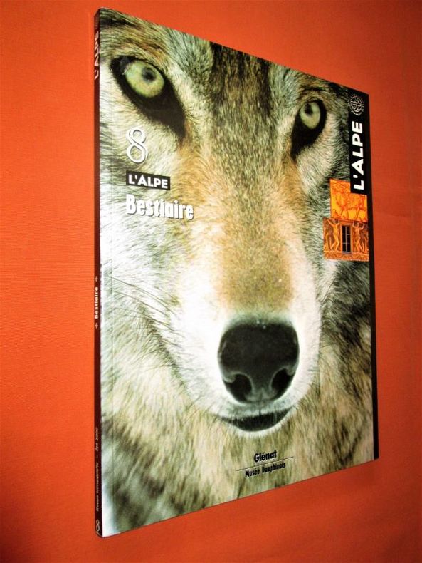
REVUE L'ALPE
Le bestiaire alpin. L'Alpe, tome 8
Glénat, 2000. In-4 broché de 29,8 x 23 x 1,2 cm , illustré en couleurs, 113 pages.-580g.L. - Très bon état.
Bookseller reference : 25493
|
|
|
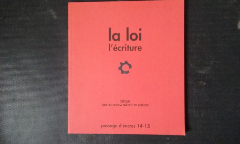
Revue Passage d'encres
La loi. L'écriture. Spécial : une interview inédite de Borges
Association Passage d'encres, 2001, in-4 br. (27,5 x 25,5), 150 p., N° 14-15 de la revue "Passage d'encres" (juin 2001), illustrations, très bon état.
Bookseller reference : QWA-9463
|
|
|
REY, W.:
Exursions suisses. (par le Valais) Les Grisons et la Haute Engadine.
Genève, les principaux librairies et Imprimerie Ch. Gruaz, 1850, in-8°, 129 p. (+ 1 p. bl.) + 1 ff. (Table), non rogné nom ms. sur la couverture, brochure originale bleue, titre et vignette sur la couverture, couv. détachée et avec qqs manques aux bords.
Bookseller reference : 24695aaf
|
|
|
REZA SHIRAZIAN.
Atlas of old Tehran.= Atlas-e Tehran-e qadîm. Introduction by Cyrus Alai.
New Persian Original bdg. HC. Folio. (34 x 24 cm). In Persian with abstracts in English. 392 p., color and b/w ills. Tehran became a major city of Iran after 1554 A.D. during the Safavid period when Shah Tahmasb I, son of Shah Ismail, ordered the implementation of two large-scale public works. The first project was the construction of ramparts and moats surrounding the entire city, which defined the city's perimeters and increased its defense. The rampart consisted of 114 towers, representing the 114 chapters within the Holy Quran and enclosed an area of 4.35 km2. The second project was the establishment of the bazaar, the heart of the industrial and commercial activities of the city, surrounded by numerous holy shrines. However, it was 240 years later in the Spring of 1796 A.D. that Tehran became the national capital of Iran, during Agha Mohammad Khan Qajar's reign. 2016 A.D. actually marks the 220th year since Tehran became the political centre of Iran. The first known map of Tehran (page 18), a Russian spy map, dates back to 1826 A.D. The next Russian map of Tehran (page 24) from 1852 A.D. was translated into Persian and presented as a gift to Naser al-Din Shah Qajar (page 29). After the establishment of the military polytechnic school in 1851 A.D. and the arrival of Europe an military instructors, the importance of accurate topographical maps was recognized by the nation's leaders. The Austrian artillery trainer for cannons, August Karl Krziz, coordinated in 1858 A.D. the preparation of the maps of Tehran (page 39) and its surrounding area (page 35). This was the beginning of scientific cartography in Iran. By 1863 A.D., maps of Tehran Province for the purpose of tax collection (page 58) were being produced by engineer Abdul Rasool Khan. Tehran dramatically expanded after a huge flood in 1867 A.D. destroyed a large portion of the Safavid period ramparts and moats, after which Alexander Bohler, a French military instructor, designed a new and enlarged rampart and moat enclosure. Within four years between 1867 A.D. and 1871 A.D., Tehran grew from 4 .35 km2 to 19.75 km2 with these new constructions. By 1891 A.D., a highly detailed and technical map of Tehran (page 64) had been produced by Abdul Ghafar Najmolmoq. During the reigning years of Mozafar al-Din Shah, Mohammad Ali Shah, and Ahmad Shah, maps for Tehran postal services (page 126) and Tehran provincial delineation (page 127) were produced. During these years, the Russian, British and French prepared several geopolitical maps of the region including Tehran. For example, the map on page 323 reproduces a map prepared in 1892 A.D. by the British Survey of India at the scale of 1:506,880. In 1914 A.D., German publisher Wagner & Debes prepared a touristic map of Tehran (page 134). In 1922 A.D. the Ministry of Culture's Investigation Section prepared a map of schools in Tehran (page 138). During the Pahlavi I period (1925~1941 A.D.), modernization of Tehran became a national priority. By 1930 A.D. a map for street enlargement in Tehran (page 158) had been published. In 1932 A.D., the demolition of the Naser al-Din Shah Qajar period ramparts began simultaneous to further expansion of urbanized Tehran. The 1936 A.D. military map of Tehran (page 169) is testimony to the changes in the urban morphology of this period. The creation of a dedicated military cartographic service in 1935 A.D. marked an important milestone in the history of cartography in Iran. The 1937 A.D. urban development plan of Tehran (page 170) clearly shows the new streets, squares and urban development envisioned. The first known aerial photograph of Tehran dating from 1940 A.D. (page 177) displays the realization of this urban development plan. After the invasions by the Russians, British and Americans in 1941 A.D., cartographic activities in Iran suddenly increased. Sergeant Mohammad Reza Ghaffari privately published maps of Tehran [.] The above mentioned maps are a few representative samples of the over 270 maps
|
|
|
RICCHIERI Giuseppe (Fiume Veneto 1861- Milano 1926)
Per la CORREZIONE dei NOMI nelle CARTE TOPOGRAFICHE. Estratto originale dalla Rivista Geografica Italiana, a. 12, fasc. II-III - 1905.
In-8° (cm. 24,2), pp. 6. Brossura editoriale. macchiolina e timbro Gabotto in cop.
|
|
|
RICCHIERI Giuseppe -
Riesame della terminologia italiana della morfologia suboceanica.
Firenze, 1924, 8vo stralcio con copertina posticcia muta, pp. 118/141. - !! ATTENZIONE !!: Con il termine estratto (o stralcio) intendiamo riferirci ad un fascicolo contenente un articolo, completo in se, sia che esso sia stato stampato a parte utilizzando la stessa composizione sia che provenga direttamente da una rivista. Le pagine sono indicate come "da/a", ad esempio: 229/231 significa che il testo è composto da tre pagine. Quando la rivista di provenienza non viene indicata é perché ci è sconosciuta. - !! ATTENTION !!: : NOT A BOOK : “extract” or “excerpt” means simply a few pages, original nonetheless, printed in a magazine. Pages are indicated as in "from” “to", for example: 229/231 means the text comprises three pages (229, 230 and 231). If the magazine that contained the pages is not mentioned, it is because it is unknown to us.

|
|
|
RICHARD CORTAMBERT
Notice sur la vie et les oeuvres de M.Jomard.
De Soye & Bouchet, 1863, 20 pages, in 8 reliure cartonnée demi chagrin, dos toilé bleu, bon état.
Bookseller reference : 12289
|
|
|
Richard J. A. Talbert (Eds. )
BARRINGTON ATLAS OF THE GREEK AND ROMAN WORLD [2 VOLUME SET] Map-By-Map Directory. Vol. 1 & 2
Very faint foxing to textblock else fine. ; 2 Volume Set; Vol. 1/2/2022; 13.1 X 10.1 X 4.5 inches; 1448 pages
|
|
|
Richard Jean-Marie Vincent Audin
Guide du voyageur en Italie
16°, mm 160x100, pp. 840, 4 di pubblicità ; tela editoriale nera con impressioni decorative a secco e titolo in oro al centro del piatto anteriore, contiene le piante ripiegate di Torino, Milano, Venezia, Roma e Napoli, il piano di Pompei e la carta delle strade della Sicilia. Decima edizione aumentata di una delle più classiche guide per i viaggiatori in Italia. ID 6475

|
|
|
Richard-Molard (J.) et Collectif
Cartes ethno-démographiques de l'Afrique Occidentale, Feuilles 1.
1952 1952 IFAN, Dakar, 1952. 2 cartes dépliantes en deux feuilles chacune. 1 chemise in-4. Bel exemplaire. Bibliothèque de Z. Ligers.
Bookseller reference : 938
|
|
|
Riedel, Glenn und Sinnwell, Armin [Hrsg.]
Die Welt der Karten. Historische und moderne Kartografie im Dialog.
Gütersloh und München, Wissen Media Verlag/Bertelsmann Lexikon Institut, 2008. Groß-4°. 36,5 x 27,5 cm. XII, 483 (1) Seiten. Original-Pappband mit Original-Schutzumschlag im Original-Pappschuber. (Atlantica - Erlebnis Erde).
Bookseller reference : 62375CB

|
|
|
Riga Giulio.
ELABORAZIONE TRIDIMANSIONALE DEL TERRITORIO.
(Codice GL/0667) In 8° (25 cm) 107 pp. Cartone editoriale, come nuovo. Allegato floppy disk ancora sigillato nella busta originale. ~~~ SPEDIZIONE IN ITALIA SEMPRE TRACCIATA

|
|
|
Riggio Giuseppe - Vitali Giuseppe
Conoscere l'Etna. Guida ai percorsi del Parco regionale
illustrazioni, 1 carta ripiegata in fondo al volume

|
|
|
Righini di S. Giorgio Alessandro*
Trattato di Topografia Terza edizione riveduta ed ampliata
*barone, Colonnello nel Corpo reale dello Stato Maggiore - Proemio - Corso elementare di Studi militari compilato per ordine del Ministero della Guerra 1+ A. 23,5x15 cm., legatura in mezza pelle, fregi e titolo (Trigonometria e Topografia) in oro al dorso, pp. 448, 231 figure nel testo, tabelle, schemi, Tavola "Itinerario da Pinerolo a Cesanne" pi? volte ripiegata e le figure 1, 2, 10 e dalla 18 alla 29 su tavole fuori testo, in italiano, una tavola staccata, ma buon esemplare. AGGIUNTO (prima): stesso Autore e stesso editore (edito nel 1856) CORSO ELEMENTARE DI TRIGONOMETRIA, manca frontespizio, pp. 137, 26 figure nel testo e numerose formule, esempi, 1 tavola "Quadro delle formule..." pi? volte ripiegata, in italiano. Piccole lacerazioni e normali segni d'uso all'esterno, annotazioni manoscritte e firme , etichetta e timbro di Biblioteca privata regolarmente pervenuto. ..." affinch? le sopra accennate lezioni pratiche di topografia possano riuscire proficue, si richiedono almeno 100 giorni di esercitazioni sul terreno, lavorando in media 12 ore al giorno" -
|
|
|
Righini, Davide (a Cura di)
Antiche Mappe Bolognesi. Le Piante Dei Beni Rurali dell'Opera Pia Dei Poveri Vergognosi
Mm 210x280 Brossura editoriale di 167 pagine, numerose illustrazioni a colori, sovraccoperta originale. Libro in condizioni di nuovo. SPEDIZIONE IN 24 ORE DALLA CONFERMA DELL'ORDINE.
|
|
|
Riitano Mariagiovanna.
UNA GEOGRAFIA PER L'EUROPA. Assetto del territorio e dinamiche evolutive.
(Codice EA/0047) In 8° (24 cm) XVIII-350 pp. Illustrato con molte figure, cartine e diagrmmi. Brossura editoriale,lievemente ingiallita, ma volume in ottimo stato. ~~~ SPEDIZIONE IN ITALIA SEMPRE TRACCIATA

|
|
|
RIMBERT (Sylvie).-
Leçons de cartographie thématique.
P., SEDES, 1968, grand in 8° broché, 139 pages ; 42 figures.
Bookseller reference : 20888
|
|
|
RINALDI Alvaro -
Il patrimonio calcografico dell'Istituto Geografico Militare.
Firenze, 1992, 8vo stralcio con copertina posticcia muta, pp. 443/454 con illustrazioni fotografiche in nero e a colori. - !! ATTENZIONE !!: Con il termine estratto (o stralcio) intendiamo riferirci ad un fascicolo contenente un articolo, completo in se, sia che esso sia stato stampato a parte utilizzando la stessa composizione sia che provenga direttamente da una rivista. Le pagine sono indicate come "da/a", ad esempio: 229/231 significa che il testo è composto da tre pagine. Quando la rivista di provenienza non viene indicata é perché ci è sconosciuta. - !! ATTENTION !!: : NOT A BOOK : “extract” or “excerpt” means simply a few pages, original nonetheless, printed in a magazine. Pages are indicated as in "from” “to", for example: 229/231 means the text comprises three pages (229, 230 and 231). If the magazine that contained the pages is not mentioned, it is because it is unknown to us.

|
|
|
Rinaudo, Costanzo.
Atlante storico per le scuole medie. Parte seconda - Il Medio Evo.
<br/> STATO: USATO, BUONO.<br/> NOTE: Piccolissima scritta a penna blu alla copertina frontale.<br/> TITOLO: Atlante storico per le scuole medie. Parte seconda- Il Medio Evo. <br/> AUTORE: Rinaudo, Costanzo.<br/> CURATORE: Disegni di Domenico Locchi.<br/> EDITORE: Paravia<br/> DATA ED.: 1938,<br/>

|
|
|
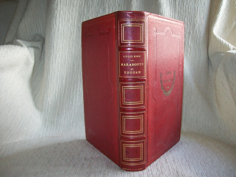
RINN Louis
MARABOUTS ET KHOUAN. Etude sur l'Islam en Algérie. Avec une carte indiquant la marche, la situation et l'importance des ordres religieux musulmans.
Alger Adolphe Jourdan 1884. Grand in-8 2 feuillets non chiffrés (faux-titre, titre) VI-VIII 2-552pp. Demi chagrin rouge, dos à nerfs orné de cadres de filets dorés, plats de percaline chagrinée rouge avec cadres de filets à froid et fers du Lycée d'Alger sur le 1er, reliure de l'époque. Avec 3 tableaux synoptiques à pleine page (philosophie des Soufi-Khelouahya en français et arabe, répartitions des ordres par départements, statistique sur les ordres), 1 très grande et belle carte en couleurs dépliante et indépendante sous couverture imprimée et pochette cartonnée (121cm x 94cm dépliée, 24,5cm x 17cm repliée). Dorure des fers de lycée ternie, rousseurs par endroits, manque de papier sur la bordure supérieure de la couverture de la carte. Exemplaire complet du texte et de la carte, reliure solide et en bon état. Taillart 3080. Etude minutieuse et très bien documentée.
Bookseller reference : GITh608
|
|
|
Riolfo Marengo,S. Riganti.A.e altri.
Enciclopedia Geografica. Geografia umana, continenti e aree di crisi, l'Italia e i suoi quadri regionali. . . regionali...
<br/> TITOLO: Enciclopedia Geografica.Geografia umana, continenti e aree di crisi, l'Italia e i suoi quadri regionali... regionali...<br/> AUTORE: Riolfo Marengo,S. Riganti.A.e altri.<br/> CURATORE: Atlante di glossario di 800 voci, 35000 dati statistici, 700 figg. <br/> EDITORE: Garzanti<br/> DATA ED.: 1995,<br/> COLLANA: Coll.Le Garzantine.<br/>
|
|
|
RISCH M.
Carte de la France hypsométrique.
- 1 carte 30 x 23 cm, pliée en deux.
Bookseller reference : 84452
|
|
|
Rittmann Alfred e Loredana.
I VULCANI.
(Codice GL/0219) In 4° (31 cm) 128 pp. Numerose foto e tavole a colori. Cartone editoriale, titolo oro, sovraccoperta. Ottimo stato. ~~~ SPEDIZIONE IN ITALIA SEMPRE TRACCIATA

|
|
|
Riva Giuseppe (Vicentino).
Sito di Roma e La Carta di Giuseppe Riva Vicentino.
Vicenza, Paroni G.Tramontini,1846.In 8°pp.58n.+ 1 Carta di Roma più volte ripiegata, mm.(800X1200).+Una veduta alla fine a piena pagina. Copertina muta.(Frontespizio impolverato).
|
|
|
RIVERAIN JEAN et DE LA RONCIERE CH
la découverte de la terre .
Larousse Paris match 1963 bon état général ,jaquette légèrement usée ,346 pages in 4.
Bookseller reference : 1397
|
|
|
RIZZI - ZANNONI.
Calabria Citeriore.
Antonio Zatta, Venezia, 1793. Incisione in rame all’acquaforte, colore d’epoca (ritoccato), cm 32,5 x 42,5 (alla lastra) più margini. Minimo foxing, buono stato di conservazione.

|
|
|
RIZZI ZANONI
PLAN DE PADOUE EN 1780
RIZZI ZANONI PLAN DE PADOUE EN 1780. , 1780, Ottimo (Fine) ottime condiz.. incisione in rame <br> in ventiquattresimo cm. 39,2 x 24,8 <br> <br> <br>

|
|
|
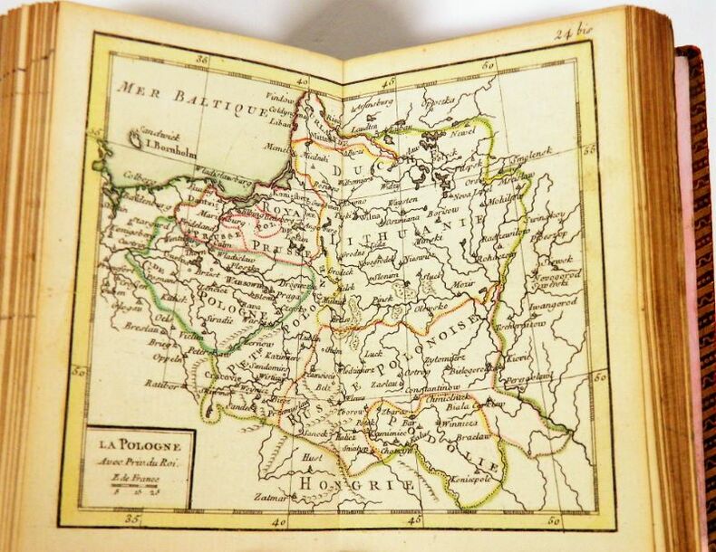
RIZZI-ZANNONI, Giovanni Antonio. BONNE, Rigobert.
Atlas Géographique contenant la Mappemonde et les quatre Parties, avec les differents Etats dEurope. Relié à la suite : BONNE, Rigobert. Idée de la Sphère, ou Principes sur la Géographie Astronomique. Paris, 1763.
Paris, chez Lattré, 1762. In-16, 8,5 x 12 cm. Reliure de lépoque en plein maroquin rouge à grain long, dos lisse richement orné de filets, caissons, dentelle et fers dorés, dentelle et pointillés dorés en encadrement des plats, roulette dorée sur les coupes, les coiffes et en encadrement des contre-plats, toutes tranches dorées. Titre, 31 planches doubles montées sur onglet ; 2 f., 55 pp. Exemplaire entièrement rehaussé à laquarelle, orné dune page de titre encadrée d'un décor gravé par Legrant, dune planche de sphères, de 2 mappemondes et de 28 cartes. Table des cartes contenues dans cet ouvrage reliée après la page de titre de lIdée de la Sphère.
Bookseller reference : 2191
|
|
|
Robbe Jacques
Methode pour apprendre facilement la geographie, dediee a monseigneur le duc du Mayne - volume I
In 8°. Pagine (26), 592, (20). Rilegatura in piena pelle coeva, sciupata e con una lieve mancanza al dorso. All'interno macchie e bruniture ed un paio di pagine presentano una lieve bruciatura. Bel frontespizio figurato con una mancanza marginale. Stato di conservazione complessivamente buono. Opera incompleta in quanto si tratta del solo primo volume sui due che la compongono. Tale primo volume è però completo in sé, comprese le 14 meravigliose carte geografiche più volte ripiegate, che sono tutte presenti ed in buono stato di conservazione. La carta d'Italia presenta una lieve lacerazione senza mancanze. Molto raro

|
|
|
Robbiani, Domenico
Genestrerio. Pagliuzze storiche nella cronaca di venti secoli
8°, 23 cm, pp. 257, numerose fotografie a piena pagina, rilegatura editoriale illustrata a colori, titolo al piatto e dorso, esempare ottimo
|
|
|
Robert / Bob G. Joplin / This Book is SIGNED AND INSCRIBED BY THE AUTHOR / Illustrations By Kurtis L. Kasner Cartography By The
Family Hike : Southern California Self Guided Nature Trails More Than 30 Self Guided Hikes Maps directions Milage Nature Trails Half Day or Whole Day Outings Time with Your Children Low Cost Exploration Natural History Animal Tracks fun
Clean and Unmarked Text: Coyote Creek Press 1985 Paperback : soft cover edition in good to better condition a typical used book with slight wear to edges and spine. Overall good / nice copy of this scarce title. Excellent reading on the subject. A good book to enjoy and keep on hand for yourself. Or would make a GREAT GIFT for the fan / reader in your life. Reading is one of the great pleasures in life. SIGNED & INSCRIBED By Author. White Cover Shows Minor Soil. ~ SCARCE TITLE ~. Illus. by Some b/w Illustrations. Travel / Culture / History / Life. Trails Maps Guidebook. Coyote Creek Press 1985
Bookseller reference : 5025858

|
|
|
ROBERT CHALLE
Journal d'un voyage aux Indes par Robert Challe écrivain du roi (1690-1691).
1979 Mercure de France, 1979, 654 pages, in 8 broché, état d'usage, usures et frottements sur les coins, les mors et les bords des plats (fendillés).
Bookseller reference : 18431
|
|
|
ROBERT CLARKE (preface)
ABC de la nature.
1990 Selection du reader's digest, 1990, bon état, 335 pages, in4° reliure editeur cartonnée avec jaquette illustrée.
Bookseller reference : 9126
|
|
|
ROBERT D.BALLARD
L'exploration du Titanic (comment fut retrouvé le plus grand navire jamais coulé).
Glénat, 1988, 64 pages, nombreuses illustrations, in 4 reliure éditeur cartonnée, état d'usage, coins frottés.
Bookseller reference : 12527
|
|
|
ROBERT DE VAUGONDY
CARTE DE LA LORRAINE ET DU BARROIS . Dans laquelle se trouvent la Généralité de Metz et autres enclaves .Dressée pour la lecture du Mémoire de M. Durival l'ainé, et dédiée au Roy de Pologne, duc de Lorraine et de Bar. Par le Sr. Robert de Vaugondy, Géog.
1756 1756 Sl , 1756 , carte gravée de 57 x 62 ( 48 x48 ) cm . Limites coloriées d' époque . Langue: Français
Bookseller reference : M18480
|
|
|
ROBERT DE VAUGONDY
ETATS DE LA COURONNE D'ARAGON OU SE TROUVENT LES ROYAUMES D'ARAGON ET DE NAVARRE LA PRINCIPAUTE DE CATALOGNE
Paris, Delamarche, fine '700. (Parte incisa: mm. 500 x 540). Carta geografica con lieve coloritura dei confini.

|
|
|
Robert de Vaugondy
Mappe Monde suivant la proiezione des cartes reduites
Incisione su rame, 240 x 395 mm. Acquarellatura probabilmente d'epoca. Nessun difetto. Proveniente da: "Nouvel Atlas Portatif destiné principalement pour l'Instruction de la Jeunesse & precedé d'un Discours sur l'Utede de la Geographie". Bel cartiglio contenente il titolo: "Mappe Monde suivant la proiezione des cartes reduites par S Robert de Vaugondy geog ord du Roi, de S. M. Polon, Duc de Lorr et de Bar, et Associè de L'Academie Royale de Nanci.

|
|
|
ROBERT DE VAUGONDY
PARTIE ORIENTALE DE L'EMPIRE DE RUSSIE EN ASIE, OU SE TROUVENT LES PROVINCES DE JAKUCKSKOY, NERCKZINSKOY, SELINGINSKOY, ILIMSKOY KRASNOJARSKOY, NARIMSKOY, JENISSEISKOY, MANGAJEISKOY ET LES CONFINS DE LA TATARIE CHINOISE. Dressée d'apres les cartes de l'Atlas Russien.
Paris, Delamarche, fine '700. (Parte incisa: mm. 500 x 540). Carta geografica con lieve coloritura dei confini.

|
|
|
 Receive by email
 Download as PDF document
 RSS feed


