|
Scafi, Alessandro
Maps of Paradise [English Edition]
The British Library, London, 2013. 176 S. ; 28 cm ; Pp. ;
Bookseller reference : 116477

|
|
|
SCAGNETTI (Francesco), GRANDE (Giuseppe)
Pianta topografica a colori di Roma antica. con 806 monumenti e opere varie // Colour map of imperial Rome with 806 monuments and other artefacts.
Rome, ME di Maggiore Cristina, (1984). Sous une enveloppe illustrée et titrée : un vol. in-4, 4 ff., index + une carte dépl. (format 100*120). Texte en anglais et en italien.
Bookseller reference : 593500
|
|
|
Scalza Ippolito (Orvieto, 1532 – 1617)
Orvieto
Magnifica prova del rarissimo primo stato (di quattro) della prima pianta a stampa di Orvieto, incisa da Giovan Battista de Cavalleris su disegno di Ippolito Scalaza. Bellissimo esemplare, in perfetto stato di conservazione.In alto al centro, sotto il bordo superiore, il titolo: ORVIETO. Ai lati della tavola sono rappresentati gli stemmi araldici della famiglia Monaldeschi; sotto a quello di sinistra la dedica: Ill. et R. D[omi]no. D. Monaldo Monalden. Cervariae D. Lungo il bordo inferiore è incisa una legenda numerica di 27 rimandi a luoghi e monumenti notabili. Segue una tabella con delle distanze della città da luoghi circonvicini: Urbsvetus Italiae Etruscoru[m] Civitas Distat ab Urbe Milia 60. à Perusio Milia 30. à Lacu Vulsinio Milia .6. à Tiberi fluvio Milia.3. in ambitu habet Milia .3. Sita est supra lapidem Tufium supra Collem existenteni Ovispetiem referens. Hunc locu[m] primum coluerunt Aramei ab eis Arbanum appellatum inde a Pelagis Oropitum, postea vero à Latinis Urbivetus. Infine, le indicazioni editoriali: Ioa. Baptista de Cavallerijs incidebat Romae 1583. In basso a destra sono incisi altri quattro stemmi, probabilmente realtivi sempre alla famiglia Monaldeschi.Orientazione fornita da una rosa dei venti, il nord–ovest è in alto. Nell’angolo superiore sinistro, evidenziata da un compasso, la scala grafica Canne di piedi, et ogni cinque piedi sono otto palmi Romaneschi (100 canne = mm 88). Acquaforte e bulino, dimensioni mm 404x525.Si tratta della prima rappresentazione topografica a stampa della città di Orvieto. Disegnata ed incisa dall’architetto e scultore orvietano Ippolito Scalza, che la dedicò a Monaldo Monaldeschi, discendente dall’antica nobile famiglia orvietana dei Monaldeschi, protagonista, insieme a quella rivale dei Filippeschi, delle vicende medievali cittadine, tanto da essere citati nel canto VI del Purgatorio dantesco.Monaldo fu autore dei Comentari Historici della città, che furono pubblicati nel 1584. Spesso lo Scalza, in possesso delle competenze tecnico-scientifiche per effettuare il rilievo topografico, fu impiegato dai Monaldeschi per le loro committenze artistiche. Come testimonia lo stesso Monaldo, il rilievo della città risale al tempo di papa Pio IV (morto nel 1565), mentre l’incisione, che deriva dai disegni dello Scalza, viene alla luce solo nel 1583 per i torchi di Giovan Battista de Cavalleris. La città è presentata su un supporto di pietra, senza alcun accenno al paesaggio circostante. Il disegno è ruotato in modo da presentare il Duomo come centro della città, esattamente equidistante dai due stemmi monaldeschi. La pianta di Scalza, ripubblicata nel 1620 da Angiola Marcucci, servì in seguito da modelloa Luca Holstenius per la rappresentazione della mappa di Orvieto nella Galleria delle carte geografiche in Vaticano. Secondo Nagler il monogramma AMF sarebbe Giacomo Marcucci, ma le iniziali identificano più correttamente Angiola Marcucci. Il doppio imprint editoriale presente nelle prove del terzo stato della lastra, dove è aggiunto Iacomo Marcucci formis, confermano che si tratti di due persone diverse, legate da un rapporto di parentela la cui relazione non è chiara.Stati & edizioni1°: come descritto, imprint Ioa. Baptista de Cavallerijs incidebat Romae 1583.2°: abrasa la firma del Cavalleris, imprint AMF. Romae 1620.3°: doppio imprint, Iacomo Marcucci formis e AMF. Romae 1620.4°: abrase le firme precedenti, imprint Gio. Batt. De Rossi.BibliografiaBrandhuber-Juffinger (2011); n. 79; Bonasera (1979): p. 88, n. 21; Christie’s (1998): n. 1022; Christie’s (2012): n. 62; Destombes (1970): n. 83; Ganado (1994): VI, n. 108 & p. 213, n. 60; Shirley (2004): III, n. 45. Benevolo (1969): pp. 82-84, tav. XVI; Brasini (1988); Fumi (1928): p. 5;Nagler (1858-79): n. 964; Satolli (2017): pp. 100-101, scheda XXX; Tooley (1939): n. 425.Censimento1°: Atlante Stevens-Beans-Nebenzahl; Malta, National Library; Salisburgo, Universitatsbibliothek. 2°: F... Magnificent example of the very rare first state (of four) of the first printed plant of Orvieto, engraved by Giovan Battista de Cavalleris on a drawing by Ippolito Scalaza. In perfect condition.At the top center, under the upper border, the title: ORVIETO.On the lateral sides of the table there are the heraldic coats of arms of the Monaldeschi family; under the left one the dedication:Ill. et R. D[omi]no. D. Monaldo Monalden. Cervariae D. along the bottom margin there's a numerical key of 27 references to the monuments and buildings, followed by the editorial details:Ioa. Baptista de Cavallerijs incidebat Romae 1583.In the lower right corner there are four other coats of arms, probably belonging to the Monaldeschi family.Orientation provided by a compass rose, the north-west is at the top. Etching and engraving, dimensions mm 404x525.Bibliography:Brandhuber-Juffinger (2011); n. 79; Bonasera (1979): p. 88, n. 21; Christie’s (1998): n. 1022; Christie’s (2012): n. 62; Destombes (1970): n. 83; Ganado (1994): VI, n. 108 & p. 213, n. 60; Shirley (2004): III, n. 45. Benevolo (1969): pp. 82-84, tav. XVI; Brasini (1988); Fumi (1928): p. 5;Nagler (1858-79): n. 964; Satolli (2017): pp. 100-101, scheda XXX; Tooley (1939): n. 425. Bifolco-Ronca (2018): tav. 1163, I/IV.

|
|
|
Scatà,Stefano. Morello,Massimo.
Australia. Il futuro della terra è nella memoria degli uomini.
<br/> TITOLO: Australia. Il futuro della terra è nella memoria degli uomini. <br/> AUTORE: Scatà,Stefano. Morello,Massimo.<br/> EDITORE: Idealibri S.r.l.<br/> DATA ED.: 2000,<br/> EAN: 9788870826616
|
|
|
SCEFFER Oscar - SCARAMELLINI Guido
STAMPE DI VALCHIAVENNA. Vedute Dal XVI al XIX Secolo.
In-8 p. oblungo, cartonato editoriale, custodia, pp. 294, con 265 riproduzioni in bianco e nero, a colori e in tinta, di antiche stampe ciascuna accompagnata da descrizione bibliografica. Allo stato di nuovo.

|
|
|
SCEFFER Oscar, SCARAMELLINI Guido
STAMPE DI VALCHIAVENNA.
Vedute Dal XVI al XIX Secolo. Morbegno, Sceffer, 2010. In-8 p. oblungo, cartonato editoriale, custodia, pp. 294, con 265 riproduzioni in bianco e nero, a colori e in tinta, di antiche stampe ciascuna accompagnata da descrizione bibliografica. Allo stato di nuovo.
Bookseller reference : 102400
|
|
|
Schackleton,Ernest.
South! The story of the 1914 - 1917. Expedition.
<br/> STATO: USATO, COME NUOVO.<br/> TITOLO: South! The story of the 1914-1917. Expedition. <br/> AUTORE: Schackleton,Ernest.<br/> DATA ED.: 2022,<br/>
|
|
|
SCHARFE, W
Historisch-topographische Karte von Brandenburg um 1800. Blätter Berlin SW und Berlin SO im Blattschnitt der Topographischen Übersichtskarte des Deutschen Reiches 1: 200 000.
Berlin, Colloquium, 1987. Gr.-8vo. 109, (1) S., 2 Bl., 2 gefaltete Karten beiliegend (Einzelveröffentl. d. Historischen Kommission zu Berlin 46). OLwd m. OUmschlag.
Bookseller reference : 1320740
|
|
|
SCHARFENSTEIN (Julius Friedrich)
Historische general Beschreibung von Ober und Nieder-Elsass, samt dem Sundgau. Nach Anleitung einer accuraten Land-Charte in 15 Taffeln in Quarto (...) Nebst einer vorrede Johann Gabriel Doppelmayers
Franckfurt und Leipzig, Felsseckerischen Buch-Laden, 1734
Bookseller reference : 002762
|
|
|
Schecter Barnet
George Washington's America: A Biography Through His Maps
New York: Walker Publishing Co. 2010. 303pp. Full colour d.j. No wear inscriptions fading or marks. A sumptuous production and very heavy. . 1st edition 1st impression. Hardback. Fine/Fine. Folio. Walker Publishing Co., Hardcover
Bookseller reference : GT396 ISBN : 0802717489 9780802717481

|
|
|
SCHEDA J.
General-Karte des Oesterreichischen Kaiserstaates mit einem großen Theile der angrenzenden Lander.
Venti parti di cm. 57 x 49 a formare una grande carta raffigurante l'impero austro-ungarico. Finemente inciso in rame. Entro custodia originale in percallina. Qualche traccia d'uso alla custodia, peraltro perfetto stato di conservazione. Cfr. Austria Picta 44.1.
|
|
|
SCHENK P. - VALK G.
TERRITORIO PADOVANO
SCHENK P. - VALK G. TERRITORIO PADOVANO. , XVIII sec., Buono (Good) Buon es.. Acquaforte acquerellata a mano <br> cm. 48 x 37.8 (inciso) <br> <br> <br>

|
|
|
SCHENK PIETER
Atlas Contractus Sive Mapparum Geographicarum Sansoniarum Auctarum et Correctarum Nova Congeries.
In Folio, (mm 540x340); fascinoso frontespizio con figure allegoriche, disegnato da G. de Lairesse e inciso da Jac. Baptist delineato da Phil. Tideman. Raffigura in primo piano al centro un angelo con tromba che porta il titolo su di uno stendardo, Nettuno emerge dalle acque e si appoggia al globo terracqueo, Europa è una elegante donna su un carro con due leoni al fianco, due putti accedono ai primi rudimenti di cartografia, sullo sfondo atlante regge il mondo. 51 carte geografiche a doppio foglio incise in rame finemente colorate d'epoca (una ripiegata), indice con aggiunta manoscritta della carta della Catalogna. Legatura moderna in piena pelle marezzata, dorso con sette nervi e scomparti riccamente decorati con piccoli ferri, titolo impresso in oro su tassello in marocchino rosso fregi in oro.<BR><BR>Attraente atlante olandese di fine secolo che raccoglie le consuete carte geografiche dei vari stati europei, due mappamondi, quattro continenti, una carta del mondo fantastico 'Schlaraffenland'. La carta della Catalogna è elencata in indice manoscritta a inchiostro bruno. Gli autori della carte sono vari e autorevoli: Janssonius, Nic. Visscher, Danckerts, De Wit, Van Keulen, Ottens, Hondius, Valk, e lo stesso Peter Schenk. Come di consueto e come cita Koeman, Vol III, p. 115, gli atlanti di Schenk sono atlanti compositi e quindi tutti diversi nel numero delle carte, tranne quello in prima edizione che ha 27 carte.<BR>La famiglia Schenk, il cui capostipite fu Pieter, fu leader del mercato olandese nella prima metà del Settecento. Pieter Schenk nacque in Germania, ma si traferì ad Amsterdam dove fu allievo di Gerard Valck di cui sposò la sorella. Le due famiglie a lungo furono in società come editori e venditori di stampe, libri, carte geografiche e globi. Bell'esemplare. Koeman, Vol III, p. 115.<BR>

|
|
|
SCHENK, PETRUM.
Continentis Italiae Pars media, seu prima meridionalis; Ecclesiae Status Tredecim, et magni Ducatus Toscani Dominium ac Territoria exhibens: penes Petrum Schenk. Cum Privil.
Amsterdam, 1703. Probabilmente tratta dall’ “Atlantis sylloge compendiosa or Nova totius Geographia” edita da Gerardum Valck ad Amsterdam all’inizio del XVIII secolo (1702 - 1710 ca.). Incisione in rame, colore d’epoca, cm 49,2 x 58 (alla lastra). Titolo entro semplice ma bel cartiglio sormontato dagli elementi papali propri del territorio romano, con a lato i nomi dei diversi territori appartenenti alla penisola italiana e in basso lo stemma mediceo con le sei “palle” (il blasone dei Medici cambiò nel numero delle “palle” e nella disposizione; la sfera centrale ha tre gigli dorati in campo azzurro, concessi dal re di Francia Luigi XI a Piero di Cosimo de’ Medici). La lastra utilizzata per questa incisione, come la maggior parte di quelle usate nella produzione di questi due editori, è quella di J. Janssonius, debitamente modificata e ritoccata. Esemplare fresco, a pieni margini, in bella coloritura e in ottimo stato di conservazione.

|
|
|
Schenk, Pieter
Pars Inferior Principatus Languedoci, Provinciae, Delphinatus, Tractus Lugdunensis, Aquitaniae, et Vasconiae, cum Descriptione Limitum Principat. Pedmontii; Comitus Nicae, et Ducatus Montferatensi, novissime in Lucem Emissa apud Petrum Schenk, 1707. [Altkolorierter Kupferstich / colored copper engraving].
o.J. Peter Schenk der Ältere, (Pieter Schenk, Petrum Schenk), geboren am 26. Dezember 1660 in Elberfeld, gestorben 1711 in Leipzig, Kupferstecher und Kartograf.
Bookseller reference : 50414BB

|
|
|
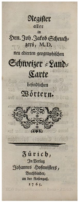
Scheuchzer, Johann Jakob
Register aller in Hrn. Joh. Jakob Scheuchzers, M.D. neu edirten geographischen Schweizer-Land-Carte befindlichen Wörtern.
Zürich, Johannes Hofmeister, 1765. Schmal 12°. 132 S. Pappbd. d. Zt. + Wichtig: Für unsere Kunden in der EU erfolgt der Versand alle 14 Tage verzollt ab Deutschland / Postbank-Konto in Deutschland vorhanden +, bild
Bookseller reference : 6486CB

|
|
|
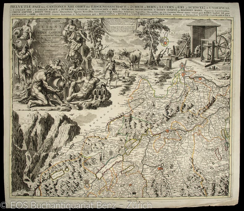
Scheuchzer, Johann Jakob (1672-1733)
Nouvelle Carte de la Suisse Divisée en ses Treize Cantons ses Alliez et ses sujets.
Amasterdam, Jean Convens et Corneille Mortier., 1730. Grenzkolorierte Kupferstich. Blattformat: 56 x 64 cm. Gesamtgrösse der vier Teile: 112 x 128 cm. + Wichtig: Für unsere Kunden in der EU erfolgt der Versand alle 14 Tage verzollt ab Deutschland / Postbank-Konto in Deutschland vorhanden +, 988DG|988DG_2|988DG_3|988DG_4 [4 Warenabbildungen]
Bookseller reference : 988DG

|
|
|
SCHEUCHZER, Johann Jakob (1672-1733):
Karte. - Nova Helvetiae tabula geographica, illustrissimis et potentissimis cantonibus et rebus publici reformatae religionis Tigurinae, Bernensi, Glaronensi, Basiliensi, Scaphusianae, Abbatis Cellanæ. Schweizerkarte in 4 Teilen zusammengestellt.
Zürich, 1712/13, 116x153 cm (ganze Karte), Kupferstichkarte der Schweiz aus 4 Teilen auf Leinwand aufgezogen, Massstab ca. 1:230’000, weiterer Titel am oberen Rand: "Helvetiae pagi seu cantones. XIII Ohrt der Eidgenossschaft...", Kartenzeichnung reicht nur bis zur Landesgrenze, Titelkartusche und Kartenrand sind reich mit figürlichen Szenen, Darstellungen von naturhistorischen Merkwürdigkeiten, sowie Landschafts- und Gebirgsdarstellungen von der Hand Johann Melchior Füsslis verziert, gestochen von Johann Heinrich Huber und Emmanuel Schalch, der rechter Hälfte etwas gedunkelt sonst guter Zustand, auf Leinwand aufgezogen, sehr schönes Exemplar. (Gerolt).
Bookseller reference : 117926aaf
|
|
|
Scheuchzer, Johann Jakob (1672-1733):
Nouvelle Carte de la Suisse Divisée en ses Treize Cantons ses Alliez et ses sujets.
Amasterdam, Jean Convens et Corneille Mortier. 1730. Grenzkolorierte Kupferstich. Blattformat: 56 x 64 cm. Gesamtgrösse der vier Teile: 112 x 128 cm.
Bookseller reference : 988DG
|
|
|
Scheuchzer, Johann Jakob:
Register aller in Hrn. Joh. Jakob Scheuchzers, M.D. neu edirten geographischen Schweizer-Land-Carte befindlichen Wörtern.
Zürich, Johannes Hofmeister, 1765. Schmal 12°. 132 S. Pappbd. d. Zt.
Bookseller reference : 6486CB
|
|
|
Schimkus, Andreas Red.:
ADAC Weltatlas. Das bild unserer Welt.
<br/> STATO: USATO, MOLTO BUONO.<br/> TITOLO: ADAC Weltatlas. Das bild unserer Welt. <br/> AUTORE: Schimkus, Andreas Red.:<br/> CURATORE: Sprache: Deutsch<br/> EDITORE: ADAC Verlag<br/> DATA ED.: 1997,<br/>
|
|
|
Schire D.
MAP COLLECTORS' SERIES No 27 BICKHAM'S BIRD EYE COUNTY VIEWS
Durant House London: Map Collectors Circle 1966. 9pp 6 plates 25pp A fine copy. Facsimile of Bickham's supplement 19th 1747. paper wrappers. Fine. 8vo - over 7�" - 9�" tall. Map Collectors Circle Hardcover
Bookseller reference : L205
|
|
|
Schire D.
MAP COLLECTORS' SERIES No 17: THE CAPE OF GOOD HOPE 1782-1842 FROM DE LA ROCHETTE TO ARROWSMITH
Durant House London: Map Collectors Circle 1964. 16pp 15 plates including one folding A fine example. Paper Wrappers. Fine. 8vo - over 7�" - 9�" tall. Map Collectors Circle Hardcover
Bookseller reference : H608
|
|
|
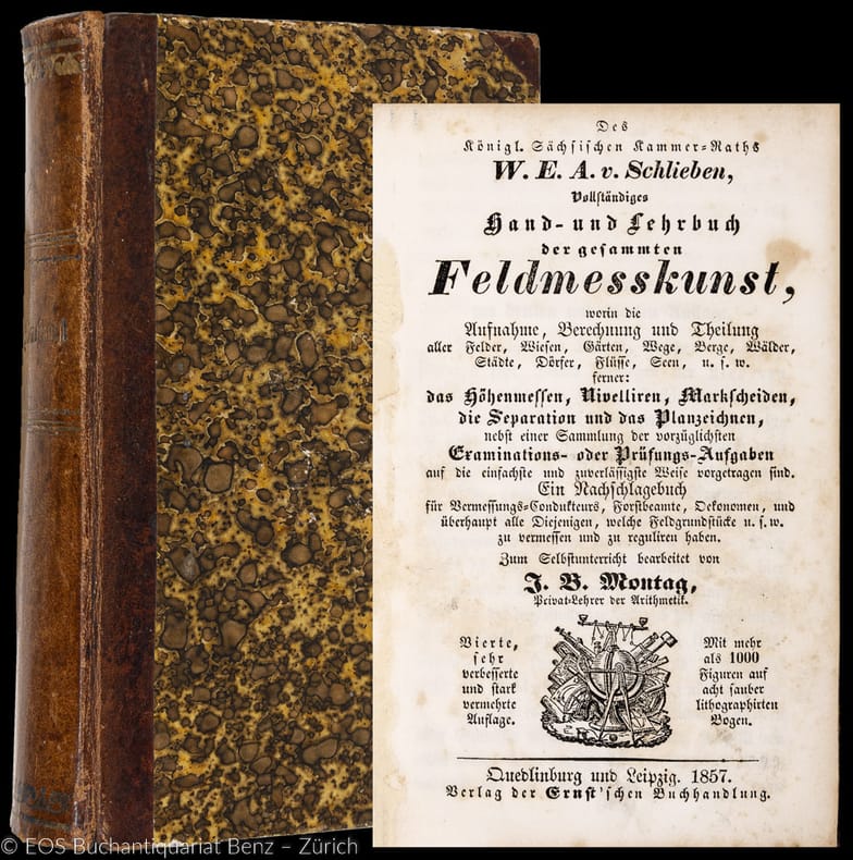
Schlieben, Wilhelm Ernst August von
Vollständiges Hand- und Lehrbuch des gesammten Feldmesskunst ... ein Nachschlagebuch ...
Quedlinburg, Ernst, 1857. 8°. XVI, 464 S. Mit 8 gef. Tafeln. Halblederband der Zeit. + Wichtig: Für unsere Kunden in der EU erfolgt der Versand alle 14 Tage verzollt ab Deutschland / Postbank-Konto in Deutschland vorhanden +, A 4., sehr verb. u. stark verm. Aufl.
Bookseller reference : 31209AB

|
|
|
Schlieben, Wilhelm Ernst August von:
Vollständiges Hand- und Lehrbuch des gesammten Feldmesskunst ... ein Nachschlagebuch ...
4., sehr verb. u. stark verm. Aufl. Quedlinburg, Ernst, 1857. 8°. XVI, 464 S. Mit 8 gef. Tafeln. Halblederband der Zeit.
Bookseller reference : 31209AB
|
|
|
Schmehl, H
Untersuchungen über ein allgemeines Erdellipsoid.
Potsdam, 1927. 4°. 72 S. OBr. Umschl.l eicht gebräunt. Teils leicht stockfl. (Veröffentl. d. Königl. Preus. Geodät. Instit. N.F. 98)
Bookseller reference : 159761
|
|
|
SCHMETS, Paul - HAYT, Franz.
ATLAS d'Histoire Universelle et d'Histoire de Belgique.
in-4°, 151 pp., nombreuses cartes en couleurs pleine page, broché, couverture illustrée. Très bel exemplaire. [P-36] Edition révisée suivant nouveau programme par Franz Hayt.
|
|
|
Schmitz-Kairo Paul
Politici e profeti sul Mar Rosso
3 carte 16 tavole in bianco e nero fuori testo

|
|
|
Schnauder, M
Polhöhenbestimmungen in d. Jahren 1902, 1903, 1908 u. 1909.
Potsdam, 1910. 4°. M. 2 lith. Taf. 100 S. OBr. Umschl. stark angeschmutzt u. eingerissen. (Veröffentlichung d. Königl. Preuszischen Geodätischen Institutes. N.F. 48)
Bookseller reference : 159731
|
|
|
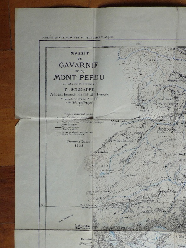
SCHRADER F.
MASSIF DE GAVARNI ET DU MONT PERDU levé dessiné et dressé par F. Schrader, Président honoraire du Club Alpin Français. 2 ème Edition. 1932. carte au 20.000 ème.
carte publiée avec le concours du Club Alpin Français. 700 mm x 750 mm.
Bookseller reference : 2025
|
|
|
Schrire D
Map Collectors' Circle Series Third Year Volume III No. 27 : Bickham's Birds Eye County Views and the British Monarchy Including the North American Supplement Reproduced in Full
London: Map Collectors' Circle 1965. Fine condition. Clean and unmarked. NOT a library discard. NO owner's name or bookplate. A bibliography of books from 1743 to 1796 containing the Bickham family's maps and calligraphic engravings. Illustrated with 31 pages of plates and facsimiles. Bound in the original tan wraps printed in black. 7.25" wide by 9.75" tall. First Edition. Softcover. Fine condition. 40pp. Great Packaging Fast Shipping. Map Collectors' Circle Paperback
Bookseller reference : 018892
|
|
|
Schrire D
Map Collectors' Circle Series Second Year Volume 2 No. 17 : The Cape of Good Hope 1782-1842 From De la Rochette to Arrowsmith Being Some Notes on the Development of the Early Mapping of European-Occupied South Africa by English Cartographers
London: Map Collectors' Circle 1965. Very Good condition. Clean and unmarked. NOT a library discard. NO owner's name or bookplate. 1965. First Edition. Described here with annotations are 41 maps of the Cape of Good Hope 1782-1842. Illustrated with 15 plates 2 foldout. Bound in the original tan wraps printed in black. 7.25" wide by 9.75" tall. First Edition. Softcover. Very Good condition. 31pp. Great Packaging Fast Shipping. Map Collectors' Circle Paperback
Bookseller reference : 018914
|
|
|
Schrire D
Map Collectors' Circle Series First Volume Vol. I No. 4 : Adams' & Pine's Maps of the Spanish Armada
London: Map Collectors' Circle 1963. Fine condition. Clean and unmarked. NOT a library discard. NO owner's name or bookplate. A cartographical history of these Armada maps from 1588 to 1753. Gives full descriptions with collations and annotations. Illustrated with 12 plates 2 fold-out. Bound in the original tan wraps printed in black. 7.25" wide by 9.75" tall. First Edition. Softcover. Near Fine condition. 22pp. Great Packaging Fast Shipping. Map Collectors' Circle Paperback
Bookseller reference : 018902
|
|
|
Schrire D.
MAP COLLECTORS SERIES NO 4: Adams' & Pine's Maps of the Spanish Armada
Durant House London: Map Collectors Circle 10pp.12 plates. A fine example. Paper Wrappers. Fine. 8vo - over 7�" - 9�" tall. Map Collectors Circle Hardcover
Bookseller reference : H603
|
|
|
Schuhardt, J
Neueste Post und Reise Karte Deutschland.
Hanau, J. Edler, 1841. Lithografische Karte mit Grenzkolorit. Blattgrösse: 54,5 x 69 cm. + Wichtig: Für unsere Kunden in der EU erfolgt der Versand alle 14 Tage verzollt ab Deutschland / Postbank-Konto in Deutschland vorhanden +, Abb.
Bookseller reference : 827CG

|
|
|
Schuler, C, J
Cartografare il Mondo
Mm 350x410 "Cartografare il mondo" è una storia della cartografia mondiale per immagini. Nel corso dei secoli la nostra conoscenza del pianeta si è sempre più approfondita grazie a viaggi ed esplorazioni e i cartografi hanno disegnato mappe sempre più accurate e precise anche delle aree più misteriose. Oggi grazie anche ai siti web siamo in grado di avere una visuale in diretta anche dei posti più lontani, ma le vecchie mappe esercitano ancora un grande fascino, testimonianza di un tempo che fu quando uomini coraggiosi, animati da uno spirito di avventura e conoscenza, si spinsero ai confini del mondo conosciuto. Cartografare il mondo ripercorre le tappe di questo progresso, partendo dal XV Secolo fino al Novecento, e contiene 400 mappe storiche, riprodotte a colori, introduzioni e spiegazioni per ogni carta presentata, nonché una cronologia che aiuta a collocare ogni mappa nel suo contesto storico. Volume cartonato rigido di pagine 496 ricchissimo apparato iconografico, sovraccoperta figurata. Edizione in Italiano, Inglese, Spagnolo e Portoghese. Nuovo. Spedizione in 24 ore dalla conferma dell'ordine.

|
|
|
Schuler,C.J.
Cartografare il mondo.
Cartografare il mondo è una storia della cartografia mondiale per immagini. Nel corso dei secoli la nostra conoscenza del pianeta si è sempre più approfondita grazie a viaggi ed esplorazioni e i cartografi hanno disegnato mappe sempre più accurate e precise anche delle aree più “misteriose”. Oggi grazie anche ai siti web siamo in gradi di avere una visuale “in diretta” anche dei posti più lontani <br/> STATO: NUOVO.<br/> TITOLO: Cartografare il mondo. <br/> AUTORE: Schuler,C.J.<br/> CURATORE: Traduzione di Cillero e De Motta.<br/> EDITORE: Logos<br/> DATA ED.: 2010,<br/> EAN: 9788857600093

|
|
|
Schulten, Adolf
Die Mosaikkarte von Madaba [Madeba] und ihr Verhältnis zu den ältesten Karten und Beschreibungen des Heiligen Landes. Mit 3 Kartenbildern und einer Figurentafel.
RARE comprehensive monograph on the Madaba Map (also known as the Madaba Mosaic Map) which is part of a floor mosaic in the early Byzantine church of Saint George at Madaba, Jordan. The Madaba Map dates to the 6th century AD and contains the oldest surviving original cartographic depiction of the Holy Land and especially Jerusalem. The author - Adolf Schulten (1870-1960) was an eminent German historian and archaeologist. Contains a reproduction of the Madaba map on two pages and full-page plate with 6 b&w figures. 270x210mm. 121 pages. Hardcover with cloth spine. Cover yellowing, stained/age-stained, somewhat curved and wrinkled. Wormholes on cover and spine. Cover edges and corners bumped and worn. Spine worn. Spine edges peeling. Spine hinges partly cracked and tattered. Sticker residues on spine bottom part. Ink writing on front inner cover, whitepage and title page. Ex-library copy with stamp on front and rear whitepages, and contents page. Wormholes on inner cover, whitepages and edges of all pages - NO damage to text. Wormholes on Madaba map with slight damage to middle part and hinge. Pages yellowing. [SUMMARY]: This extremely rare book on the oldest map of the Holy Land and Jerusalem has sustained some damage, but is still in good reading condition.
|
|
|
Schumann,Walter.
Der neue BLV Steine - und Mineralienführer.
<br/> STATO: USATO, MOLTO BUONO.<br/> NOTE: Mende alla sopracoperta.<br/> TITOLO: Der neue BLV Steine- und Mineralienführer. <br/> AUTORE: Schumann,Walter.<br/> CURATORE: Über 600 Einzelstücke in Farbe.<br/> EDITORE: BLV<br/> DATA ED.: 1991,<br/> EAN: 9783405131227
|
|
|
Schumann,Walter.
Guide des pierres et minéraux. Roches, gemmes et météorites.
<br/> STATO: USATO, MOLTO BUONO.<br/> TITOLO: Guide des pierres et minéraux. Roches, gemmes et météorites. <br/> AUTORE: Schumann,Walter.<br/> EDITORE: Delachaux et Niestlé<br/> DATA ED.: 1994,<br/> COLLANA: Coll.Les Guides du Naturaliste.<br/> EAN: 9782603006801
|
|
|
Schwartz Seymour I.; & Ralph E. Ehrenberg
The Mapping of America
New York: Harry N. Abrams Inc 1980. Near Fine condition in a Near Fine dust jacket. The jacket is protected by a removable Brodart clear-plastic sleeve. NOT a library discard. NO underlining. NO highlighting. NO margin notes. Sharp corners. Previous owner's bookplate. Small remainder mark on bottom edge. 1980. This is the Harry N. Abrams First Edition NOT the commom Wellfleet reprint. Among 354 illustrations are 223 maps 84 in full color. A classic work. Bound in the original white cloth stamped in bright gold on the spine. Complete with dust jacket. Oversize Hardcover. Oblong. 11.75" wide by 11" tall by 1.75" thick. This large heavy book will require extra postage for Priority and International shipments but only the standard charge for media mail. First Edition. Oversize Hardcover. Near Fine condition/Near Fine dust jacket. 363pp. Great Packaging Fast Shipping. Harry N. Abrams, Inc Hardcover
Bookseller reference : 021804 ISBN : 0810913070 9780810913073
|
|
|
Schwartz Seymour I.; & Ralph E. Ehrenberg
The Mapping of America
New York: Harry N. Abrams Inc 1980. Fine condition in a Near Fine dust jacket. The jacket is protected by a removable Brodart clear-plastic sleeve. NOT a library discard. Pages are fresh crisp clean and unmarked. Sharp corners. NO owner's name or bookplate. NOT a remainder. 1980. This is the Harry N. Abrams First Edition NOT the commom Wellfleet reprint. Among 354 illustrations are 223 maps 84 in full color. A classic work. Bound in the original white cloth stamped in bright gold on the spine. Complete with dust jacket. Oversize Hardcover. Oblong. 11.75" wide by 11" tall by 1.75" thick. This large heavy book will require extra postage for Priority and International shipments but only the standard charge for media mail. First Edition. Oversize Hardcover. Fine condition/Near Fine dust jacket. 363pp. Great Packaging Fast Shipping. Harry N. Abrams, Inc Hardcover
Bookseller reference : 021803 ISBN : 0810913070 9780810913073
|
|
|
Schwartz Seymour I.
The mismapping of America.
pp. 233, cm 23x15, paperback edition.
|
|
|
Schweydar, W
Harmonische Analyse d. Lotstörungen durch Sonne u. Mond.
Potsdam, 1914. 4°. 72 S. OBr. Umschl. leicht angeschmutzt. (Veröffentl. d. Königl. Preusz. Geodät. Inst. N.F. 59)
Bookseller reference : 159738
|
|
|
Schweydar, W
Theorie d. Deformation d. Erde durch Flutkräfte.
Potsdam, 1916. 4°. 51 S. OBr. Umschl. angeschmutzt u. leicht eingerissen. (Veröffentl. d. Königl. Preusz. Geodät. Inst. N.F. 66)
Bookseller reference : 159741
|
|
|
Schwind, F. (Hrsg.)
Geschichtlicher Atlas von Hessen. Text- u. Erläuterungsband.
Marburg, 1984. 4°. M. 3 beilieg. Faltktn. XIV, 338 S. OLwd. Rücken m. kl. Fleck.
Bookseller reference : 621087
|
|
|
Schworella, Rudolf (Hrsg.)
Kurzer Leitfaden zur Orientirung im Gebiete der neueren Kartographie u. Geographie hrsg. v. d. Buchhandlung Schworella u. Heick, Wien.
Wien, Schworella & Heick 1881. Korrekturexemplar. 106 S., 31 S., mit Blankoblättern, 1 Karte, OHLn., berieb., geschossen, angestaubt, Ecken etw. bestoß., vord. flieg Vorsatz fehlt, zahlr. Anmerkungen von alter Hand.
Bookseller reference : KART0136
|
|
|
Schäfke, Werner und Bodsch, Ingrid (Hrsg.)
Der Lauf des Rheines. Der Mittelrhein in illustrierten Reisebeschreibungen, Alben, Panoramen und Karten des 17. bis 19. Jahrhunderts aus den Beständen der Bibliothek und der Graphischen Sammlung des Kölnischen Stadtmuseums, der Stadthistorischen Bibliothek Bonn und des Stadtmuseums Bonn herausgegeben von Werner Schäfke und Ingrid Bodsch.
Köln, Bonn, Kölnisches Stadtmuseum, 1993. Folio. 41 x 31 cm. 127 Seiten. Original-Leinenband.
Bookseller reference : 45225AB

|
|
|
Scillacio,Nicola.
Delle isole del Mare Meridiano e Indiano recentemente scoperte.
<br/> STATO: USATO, MOLTO BUONO.<br/> TITOLO: Delle isole del Mare Meridiano e Indiano recentemente scoperte. <br/> AUTORE: Scillacio,Nicola.<br/> CURATORE: A cura di Osvaldo Baldacci.<br/> EDITORE: Olschki Ed.<br/> DATA ED.: 1992,<br/> COLLANA: Coll.Colombiana.<br/> EAN: 9788822239761
|
|
|
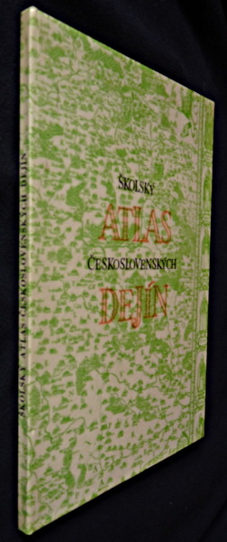
Scipak Jozef,Ulrich Stefan
Skolsky atlas ceskoslovenskych Dejin
Slovenska kartografia Album cartonné 1970 In-4 ( 21,5 x 30 cm.), album cartonné, couverture illustrée, 44 planches couleurs et 31 pages de commentaire, texte en slovaque ;plats à peine défraîchis, intérieur frais, très bon état. Livraison a domicile (La Poste) ou en Mondial Relay sur simple demande.
Bookseller reference : qi1395
|
|
 Receive by email
 Download as PDF document
 RSS feed


