|
Merian, Matthäus
Duisburg [1647]. [Original-Kupferstich, gerahmt / signed original colored etching, framed].
o.J. Matthäus Merian der Ältere, geboren am 22. September 1593 in Basel, gestorben am 19. Juni 1650 in Langenschwalbach. Schweizerisch-deutscher Kupferstecher und Verleger von Landkarten, Städteansichten und Chroniken heraus. Hauptwerk: Topographia Germaniae. [2 Warenabbildungen]
Bookseller reference : 60312BB

|
|
|
Merian, Matthäus
Eller. [um 1650]. [Original-Kupferstich, gerahmt / signed original colored etching, framed].
o.J. Matthäus Merian der Ältere, geboren am 22. September 1593 in Basel, gestorben am 19. Juni 1650 in Langenschwalbach. Schweizerisch-deutscher Kupferstecher und Verleger von Landkarten, Städteansichten und Chroniken heraus. Hauptwerk: Topographia Germaniae. [2 Warenabbildungen]
Bookseller reference : 60336BB

|
|
|
Merian, Matthäus
Gründe alte Freye Berg Statt auff dem Hartz. [um 1654]. [Original-Kupferstich, gerahmt / signed original colored etching, framed].
o.J. Caspar Merian, geboren 1627 in Frankfurt am Main, gestorben 1686 Schloss Waltha/Westfriesland. Sohn und Schüler des Kupferstechers Matthäus Merian d. Ä. Führte nach dem Tod des Vaters den Frankfurter Verlag gemeinsam mit seinem Bruder Matthäus d. J. Herausgegebene Hauptwerke 'Topographia Germaniae' und 'Theatrum Europaeum'. [3 Warenabbildungen]
Bookseller reference : 60340BB

|
|
|
Merian, Matthäus
Langesen Sampt dem Hüttenwerck vor dem Hartz gelegen. [1654]. [Original-Kupferstich, gerahmt / signed original colored etching, framed].
o.J. Matthäus Merian der Ältere, geboren am 22. September 1593 in Basel, gestorben am 19. Juni 1650 in Langenschwalbach. Schweizerisch-deutscher Kupferstecher und Verleger von Landkarten, Städteansichten und Chroniken heraus. Hauptwerk: Topographia Germaniae. [2 Warenabbildungen]
Bookseller reference : 60318BB

|
|
|
Merian, Matthäus
Lautenthal. F.B.L. Freije Bergstatt auff dem Hartz. [1654]. [Original-Kupferstich, gerahmt / signed original colored etching, framed].
o.J. Matthäus Merian der Ältere, geboren am 22. September 1593 in Basel, gestorben am 19. Juni 1650 in Langenschwalbach. Schweizerisch-deutscher Kupferstecher und Verleger von Landkarten, Städteansichten und Chroniken heraus. Hauptwerk: Topographia Germaniae. [2 Warenabbildungen]
Bookseller reference : 60316BB

|
|
|
Merian, Matthäus
Osteroda. [1652]. [Original-Kupferstich, gerahmt / signed original colored etching, framed].
o.J. Matthäus Merian der Ältere, geboren am 22. September 1593 in Basel, gestorben am 19. Juni 1650 in Langenschwalbach. Schweizerisch-deutscher Kupferstecher und Verleger von Landkarten, Städteansichten und Chroniken heraus. Hauptwerk: Topographia Germaniae. [3 Warenabbildungen]
Bookseller reference : 60382BB

|
|
|
Merian, Matthäus
Stockholm. [1646]. [Original-Kupferstich, gerahmt / signed original colored etching, framed].
o.J. Matthäus Merian der Ältere, geboren am 22. September 1593 in Basel, gestorben am 19. Juni 1650 in Langenschwalbach. Schweizerisch-deutscher Kupferstecher und Verleger von Landkarten, Städteansichten und Chroniken heraus. Hauptwerk: Topographia Germaniae. [2 Warenabbildungen]
Bookseller reference : 60313BB

|
|
|
Merian, Matthäus
Stättlein Saltza. [1653]. [Original-Kupferstich, gerahmt / signed original colored etching, framed].
o.J. Matthäus Merian der Ältere, geboren am 22. September 1593 in Basel, gestorben am 19. Juni 1650 in Langenschwalbach. Schweizerisch-deutscher Kupferstecher und Verleger von Landkarten, Städteansichten und Chroniken heraus. Hauptwerk: Topographia Germaniae. [3 Warenabbildungen]
Bookseller reference : 60384BB

|
|
|
Merian, Matthäus
Sultzburg. [1643]. [Original-Kupferstich, gerahmt / signed original colored etching, framed].
o.J. Matthäus Merian der Ältere, geboren am 22. September 1593 in Basel, gestorben am 19. Juni 1650 in Langenschwalbach. Schweizerisch-deutscher Kupferstecher und Verleger von Landkarten, Städteansichten und Chroniken heraus. Hauptwerk: Topographia Germaniae. [2 Warenabbildungen]
Bookseller reference : 60314BB

|
|
|
MERIAN, Matthäus (1593-1650):
(Schweiz) Topographia Helvetiae, Rhaetiae, et Valesiae: Das ist Beschreibung unnd eygentliche Abbildung der vornehmsten Stätte und Plätze in der Hochlöblichen Eydgenossenschaft, Graubündten, Wallis, und etlicher zugewandten Orthen. In dieser andern Edition mit sonderm fleiss durchgangen, und von vorigen Fehlern corrigirt, vermehrt und gebessert. Faksimile Neuausgabe der Ausgabe: Franckfurt am Mayn, Merianische Erben, 1654. Mit einem Nachwort herausgegeben von Lucas Heinrich Wüthrich. Neuausgabe.
Kassel und Basel, Bärenreiter, 1960, gr. in-4°, 90 S. + 80 Tafeln (davon 69 Falttafeln)+ X (Register) + 10 S. (Nachwort) + 2 Bl. Ausgabenübersicht, Verzeichniss d. Kupfer, fester Original-Pappband. OU (mit kl. Risse).
Bookseller reference : 55911aaf
|
|
|
MERIAN, Matthäus (1593-1650):
(Schweiz) Topographia Helvetiae, Rhaetiae, et Valesiae: Das ist Beschreibung unnd eygentliche Abbildung der vornehmsten Stätte und Plätze in der Hochlöblichen Eydgenossenschaft, Graubündten, Wallis, und etlicher zugewandten Orthen. In dieser andern Edition mit sonderm fleiss durchgangen, und von vorigen Fehlern corrigirt, vermehrt und gebessert. Faksimile Neuausgabe der Ausgabe: Franckfurt am Mayn, Merianische Erben, 1654. Mit einem Nachwort herausgegeben von Lucas Heinrich Wüthrich.
Kassel und Basel, Bärenreiter, 1960, gr. in-4°, 90 S. + 80 Tafeln (davon 69 Falttafeln)+ X (Register) + 10 S. (Nachwort), Original-Pappband mit Blindprägung, Orig.-Umschl. + Original-Schutzhülle (Schuber).
Bookseller reference : 109796aaf
|
|
|
MERIAN, Matthäus (1593-1650):
(Schweiz) Topographia Helvetiae, Rhaetiae, et Valesiae: Das ist Beschreibung unnd eygentliche Abbildung der vornehmsten Stätte und Plätze in der Hochlöblichen Eydgenossenschaft, Graubündten, Wallis, und etlicher zugewandten Orten.
In Druck gegeben u. Verlegt Durch Matthaeum Merian. M.DC.XLII. (1642), in-4to, 72 S. (gest. Titelblatt inkl.) + 4 Bl. Namen Register. Exemplar ohne Kupfertafeln, Orig. Perkament-Einband, braunes Leder Titelschild am Rücken.
Bookseller reference : 127479aaf
|
|
|
Meriso Pepi (fotografie), Turri Eugenio (testo).
IL VOLTO DI UNA TERRA : L'ITALIA.
(Codice IT/0116) In 4° (cm 31,5) 180 pp. Presentazione di Carlo Bo. Vedute di città e campagne d'Italia in una serie di fotografie d'arte, in nero e a colori, molte a doppia pagina. Pregiata edizione, a cura della Esso Italiana. Legatura cartone editoriale, titiolo oro sovraccoperta. Ottimo. ~~~ SPEDIZIONE IN ITALIA SEMPRE TRACCIATA

|
|
|
MERULA PAOLO
Italiae specialis membrum alterum in quo novae seu accessoriae descriptio.
In 12° (mm 130x75); pagine 819-1104 con 10 carte geografiche incise in rame ripiegate di Bresciano, Cremonese, Cremasco, Lago Lario, Milanese, Veronese, Padovano, Friuli, Istria, Piemonte. Bella legatura in pergamena coeva con titolo in oro su tassello al dorso, tagli spruzzati. Ben conservato. Pag. 1065 con piccolo strappo, fogli un po’ ingialliti. Il testo descrive Romagna, Piemonte, Lombardia e Veneto. Contiene anche Gaspare Contarini “De republica venetorum”. Si tratta di un volume della ampia “Cosmographia “ di Merula.

|
|
|
MESSINA Roberto -
Bibliotheca geographica. Mostra di opere a stampa (secc. XV-XIX). Catalogo.
Rieti, Arti grafiche Nobili Sud, 1991, 4to album brossura originale con copertina illustrata a colori, pp. 406 completamente illustrato da riproduzioni in nero e a colori. Ottimo catalogo di libri di viaggi e cartografia.
|
|
|
Messner Reinhold
MONTAGNE Immagini Pensieri Per riuscire a salvare la montagna ? fondamentale che le generazioni future ne capiscano i valori
Coordinamento editoriale, Valeria Camaschella - Coordinamento grafico, Marco Volpati - Fotografie: Archivio Messner-Studio Bi quattro-Fulvio Roiter - Legatura, Legatoria del Verbano - Prefazione - Introduzione - numerosi scritti per le immagini e sui pensieri- In antiporta bellissima immagine Eruzione dell'Etna 1 34x23 cm., legatura cartonata con stupende immagini a colori, riprodotte anche sulla sopraccoperta, pp. 192, riccamente illustrate da belle immagini a colori, prima edizione, in italiano, ottimo stato. Timbro etichetta. In questo libro Messner ha voluto dare il suo contributo per l'anno Internazionale delle Montagne, facendone un vero inno alla montagna e alle sue genti: perch? la montagna non ? fatta soltanto di rocce, ghiacciai, orizzonti di sogno, ma anche di persone che la vivono lottando quotidianamente contro le difficolt? di un ambiente ostile...a lui sta a cuore l'eredit? dell'alpinismo, quel viaggio al confine del mondo e di se stessi...premono quei valori che non hanno prezzo, perch? nel loro rispetto vengono premiati soltanto la capacit? di assumersi delle responsabilit? e il coraggio di fallire.- "Anche le montagne della mia vita sono fatte di curiosit?, speranza ed entusiasmo: Un po' meno di roccia e ghiaccio. Lass? ho vissuto il dubbio, la paura e la disperazione. Ma soprattutto la gioia di ritornare tra gli uomini"
|
|
|
METTRIER (Henri)
Un plan de Division régionale de la France en 1790
P., Imp. Nationale, 1923, in-8, 55pp. Extrait broché
Bookseller reference : VLE-562
|
|
|
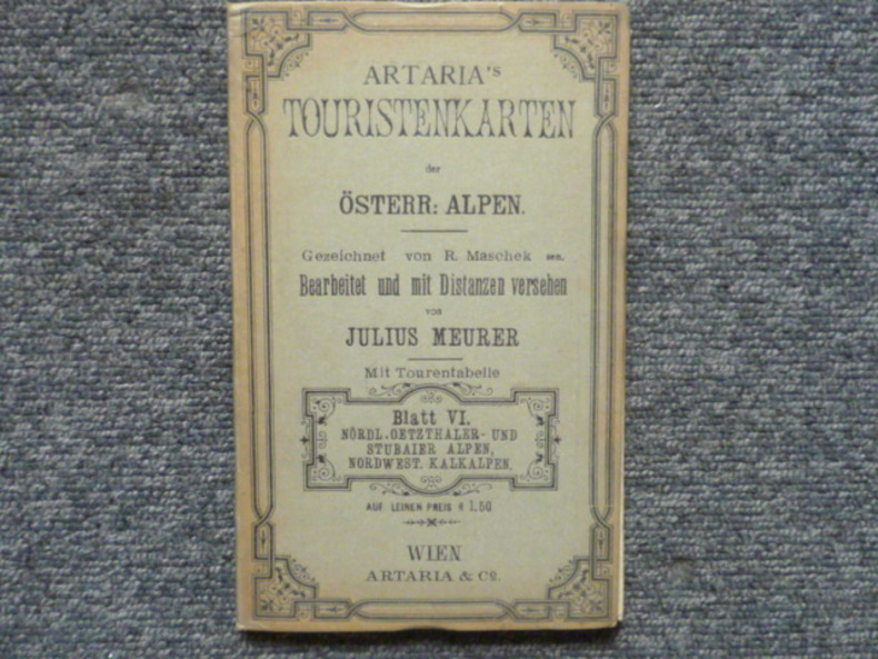
MEURER Julius
Artaria's Touristenkarten der Österreichischen Alpen. Gezeichnet von R. MASCHEK sen. Bearbeitet und mit Distanzen versehen von Julius MEURER. Mit Tourentabelle. - Blatt VI. Nördl.Oetzthaler- und Stubaier Alpen, nordwest. Kalkapen.
Artaria & Co Wien 1890 Belle carte entoilée ( 770 X 770 mm. dépliée ) en 18 segments sous couverture de percaline amande ( 190 X 120 mm ). Très bel état.
Bookseller reference : 793281
|
|
|
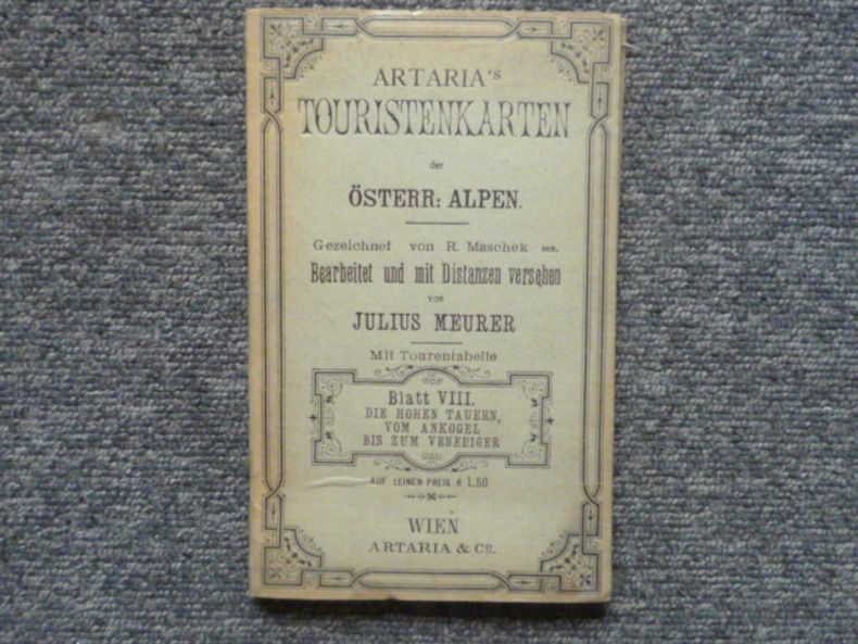
MEURER Julius
Artaria's Touristenkarten der Österreichischen Alpen. Gezeichnet von R. MASCHEK sen. Bearbeitet und mit Distanzen versehen von Julius MEURER. Mit Tourentabelle. - Blatt VIII. Die hohen Tauern, vom Ankogel bis zum Venediger.
Artaria & Co Wien 1890 Belle carte entoilée ( 570 X 580 mm. dépliée ) en 15 segments sous couverture de percaline amande ( 190 X 120 mm ). Très bel état.
Bookseller reference : 529469
|
|
|
MEURER Julius
Artaria's Touristenkarten der Österreichischen Alpen. Gezeichnet von R. MASCHEK sen. Bearbeitet und mit Distanzen versehen von Julius MEURER. Mit Tourentabelle. - Blatt XI. Garda See Adamello Gruppe
Artaria & Co Wien 1890 Belle carte entoilée ( 560 X 590 mm. dépliée ) en 15 segments sous couverture de percaline amande ( 190 X 120 mm ). Très bel état.
Bookseller reference : 268283

|
|
|
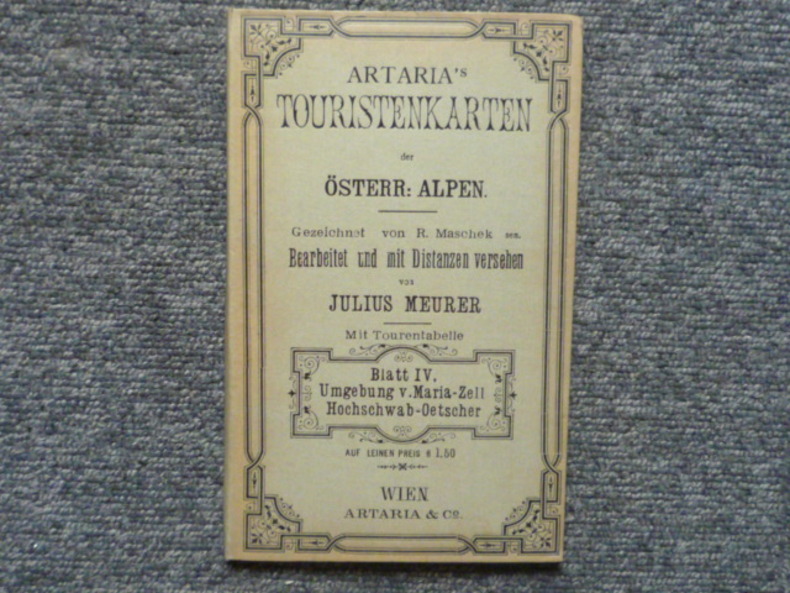
MEURER Julius
Artaria's Touristenkarten der Österreichischen Alpen. Gezeichnet von R. MASCHEK sen. Bearbeitet und mit Distanzen versehen von Julius MEURER. Mit Tourentabelle. - Blatt IV. Umgebung V.Maria-Zell Hochschwab-Oetscher.
Artaria & Co Wien 1892 Belle carte entoilée ( 640 X 470 mm. dépliée ) en 16 segments sous couverture de percaline amande ( 190 X 120 mm ). Très bel état.
Bookseller reference : 786449
|
|
|
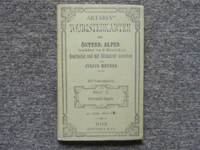
MEURER Julius
Artaria's Touristenkarten der Österreichischen Alpen. Gezeichnet von R. MASCHEK sen. Bearbeitet und mit Distanzen versehen von Julius MEURER. Mit Tourentabelle. - Blatt X. Dolomit-Alpen.
Artaria & Co Wien 1898 Belle carte entoilée ( 560 X 710 mm. dépliée ) en 18 segments sous couverture de percaline amande ( 190 X 120 mm ). Très bel état.
Bookseller reference : 408100
|
|
|
MEURER Julius
Artaria's Touristenkarten der Österreichischen Alpen. Gezeichnet von R. MASCHEK sen. Bearbeitet und mit Distanzen versehen von Julius MEURER. Mit Tourentabelle. - Blatt III. Östliche Oberösterreichische und Ennsthaler Alpen.
Artaria & Co Wien 1893 Belle carte entoilée ( 630 X 470 mm. dépliée ) en 16 segments sous couverture de percaline amande ( 190 X 120 mm ). Très bel état.
Bookseller reference : 176628

|
|
|
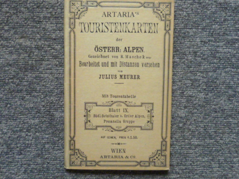
MEURER Julius
Artaria's Touristenkarten der Österreichischen Alpen. Gezeichnet von R. MASCHEK sen. Bearbeitet und mit Distanzen versehen von Julius MEURER. Mit Tourentabelle. - Blatt IX. Südl.Oetzthaler u. Ortler Alpen, Presanella Gruppe.
Artaria & Co Wien 1890 Belle carte entoilée ( 570 X 590 mm. dépliée ) en 15 segments sous couverture de percaline amande ( 190 X 120 mm ). Très bel état.
Bookseller reference : 306022
|
|
|
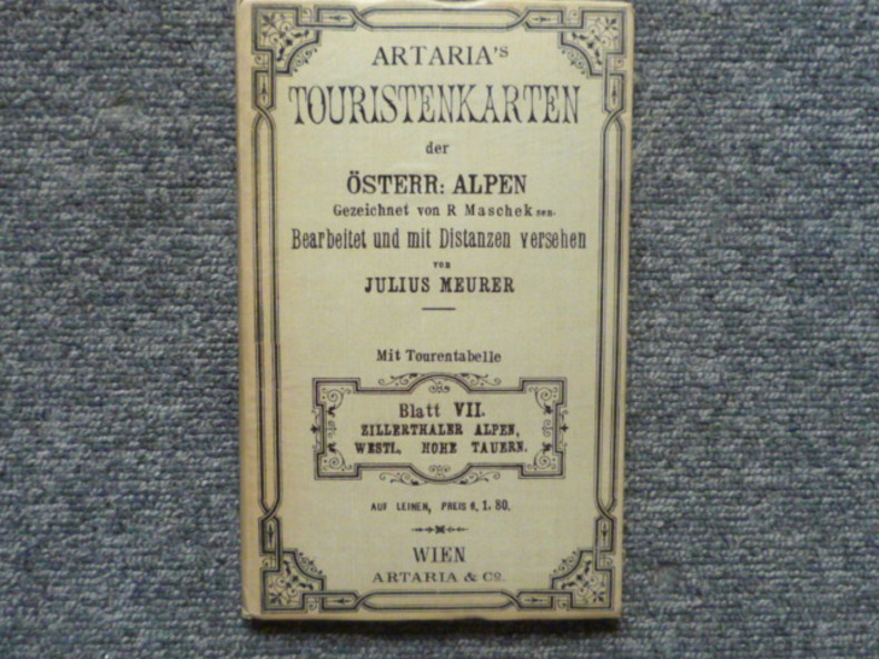
MEURER Julius
Artaria's Touristenkarten der Österreichischen Alpen. Gezeichnet von R. MASCHEK sen. Bearbeitet und mit Distanzen versehen von Julius MEURER. Mit Tourentabelle. - Blatt VII. Zillerthaler Alpen, Westl, Hohe Tauern.
Artaria & Co Wien 1890 Belle carte entoilée ( 770 X 580 mm. dépliée ) en 20 segments sous couverture de percaline amande ( 190 X 120 mm ). Très bel état.
Bookseller reference : 8667
|
|
|
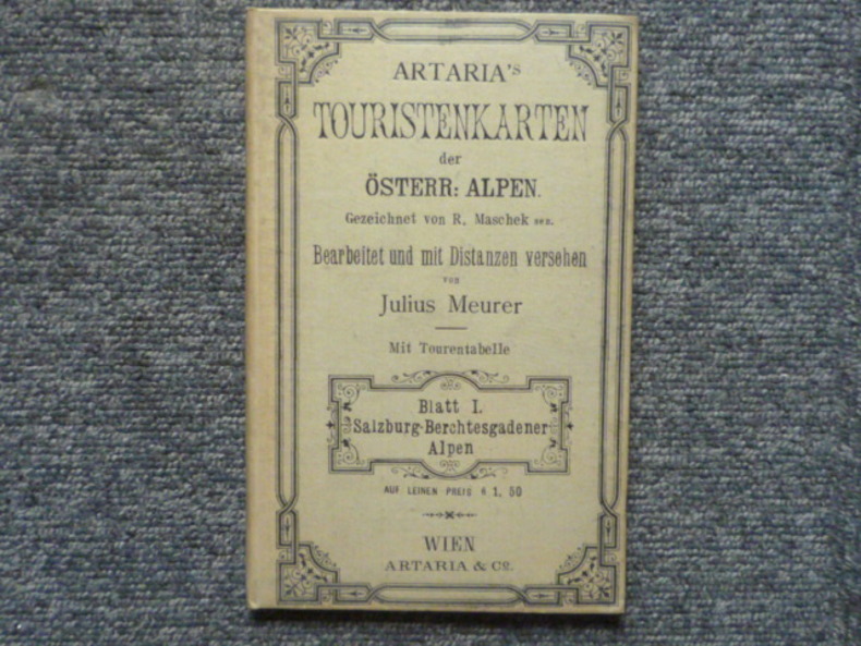
MEURER Julius
Artaria's Touristenkarten der Österreichischen Alpen. Gezeichnet von R. MASCHEK sen. Bearbeitet und mit Distanzen versehen von Julius MEURER. Mit Tourentabelle. - Blatt I. Salzburg-Berchtesgadener Alpen.
Artaria & Co Wien 1892 Belle carte entoilée ( 560 X 570 mm. dépliée ) en 15 segments sous couverture de percaline amande ( 190 X 120 mm ). Très bel état.
Bookseller reference : 162492
|
|
|
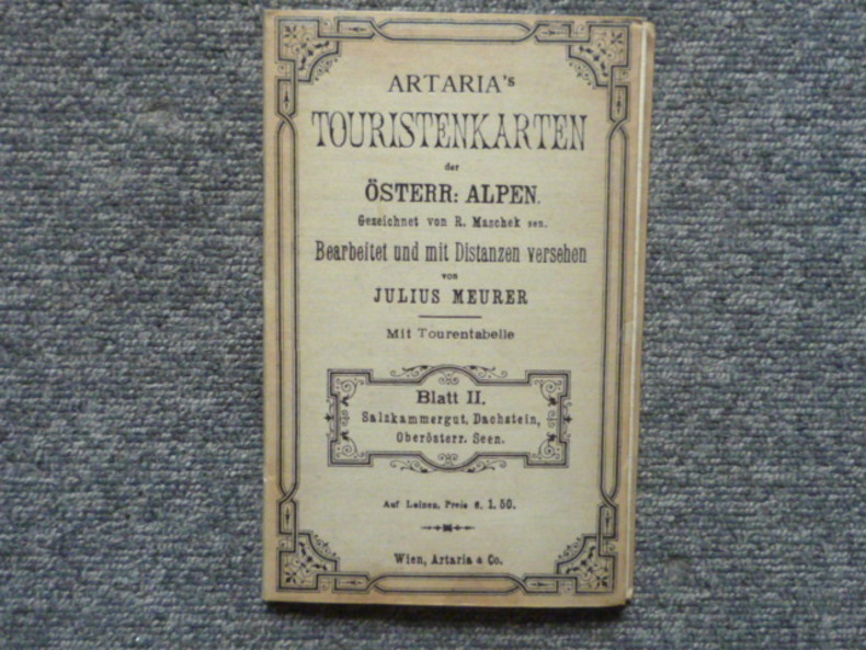
MEURER Julius
Artaria's Touristenkarten der Österreichischen Alpen. Gezeichnet von R. MASCHEK sen. Bearbeitet und mit Distanzen versehen von Julius MEURER. Mit Tourentabelle. - Blatt II. Salzkammergut, Dachstein, Oberösterr. Seen.
Artaria & Co Wien 1893 Belle carte entoilée ( 650 X 470 mm. dépliée ) en 16 segments sous couverture de percaline amande ( 190 X 120 mm ). Très bel état.
Bookseller reference : 616408
|
|
|
MEURSIUS, IOHANNES (VAN MEURS).
Hollandiae Comitatus una cum Ultrajectino Dominio.
Senza indicazioni ma Amsterdam, Reinier e Josua Ottens, 1740 circa. In alto a destra, fuori dalla battuta della lastra, si legge: "Meursii tomo X Col I". Incisione in rame all'acquaforte, b/n, cm 47 x 55,5 circa (alla lastra). Rifilati i margini laterali alla battuta, ingiallimento e sporadico foxing, qualche difetto della carta ma stampata su carta forte e nell'insieme in discreto stato di conservazione.
|
|
|
MEXICO COLOR PICTORIAL MAP Fernandez Justino. Preface byManuel Toussaint. Fernandez Justino cartography.
Patzcuaro.
Mexico.: Impreso en Talleres de Impresion de Estampillas y Valores. First Edition. 1936. Hard bound volume 9 x 7 inches 70 pp. Corners bumped; bookplate on verso of front cover; contents in very good condition. There are two folding color lithographic maps in the volume's rear pocket. One map 21 x 29.5 inches depicts in great detail the town itself while the other map 22 x 30 inches situates the town in the wider context of the lake region. This second map has a small triangular tear at one fold easily repaired and a small area of paper loss at one of the folds. Overall the bright and colorful maps are in very good condition. Pátzcuaro is a volume in the series Publicationes de la Secretaria de Hacienda y Credito Publico focusing on three towns in in the state of Michoacán: Pátzcuaro Morelia and Uruapan. The text is divided into four sections: the first provides geographical and statistical data relating to Pátzcuaro; the other three focus on the history of the city; the city as it exists in the present 1936; the lake region in which the city is situated. An interesting and uncommon volume in very good condition. TEXT IN SPANISH. . Impreso en Talleres de Impresion de Estampillas y Valores. unknown
Bookseller reference : 50269

|
|
|
Meyer, G
Alte Karten u. Globen als Spiegel d. Weltbildes ihrer Zeit. Ausstellungskatalog.
Lübeck, 1981. M. 25 Ktn. u. mehr. Abb. 67 S. OBroschur (angestaubt, begriffen). (Veröff. d. Senat d. Hansestadt Lübeck 18).
Bookseller reference : 214189
|
|
|
Meyer, Johannes; Rodtgießer, Andres Lorensen
Landtcarte von der Grafschaft Pinnenberg, 1650. [Altkolorierter Kupferstich, gerahmt / handcolored copper engraving, framed].
o.J. [4 Warenabbildungen] (Johannes Mejer, geboren 1606 in Husum, gestorben 1674. Mathematiker und Kartograf).
Bookseller reference : 60952BB

|
|
|
Mezzapesa S.
Planimetria di Roma suburbio Agro romano con 122 tavole a scale varie
In folio massimo, legatura in vilpelle, 122 tavole f.t.

|
|
|
Mich le Galand / Bram Vannieuwenhuyze
geschiedenis van Belgi in 100 oude kaarten.
, Lannoo, 2022 Gebonden, Hardcover, 407 pag. rijkelijk ge llustreerd, 35x28cm. ISBN 9789401476126.
Bookseller reference : 62243
|
|
|
MICHAEL LEVEY, conservateur-adjoint
Bref historique de la national Gallery Londres.
Pitkin Pictorials LTD, joyaux de Grande Bretagne, environ année 1960, bon état, brochure de 24 pages, in8.
Bookseller reference : 5371
|
|
|
MICHAEL LEWIS
L'invincible Armada.
1975 Saint Clair, 1975, 349 pages, in 8 reliure éditeur cartonnée skaivertex noir, rouge et or, dos et mors skaivertex marron, titres or, bon état.
Bookseller reference : 18614
|
|
|
MICHEL, P.F. - RAYMOND.
Genes.
Francia, 1830 circa. Incisione in rame all'acquaforte, b/n, cm 50,5 x 68,5 (alla lastra) più margini. Carta con il Golfo, fino a comprendere parte del Ducato di Piacenza e quello di Mantova, comprendente quindi un ampissimo raggio di territorio. Un po' di ingiallimento all'estremo margine laterale sinistro, buono stato.

|
|
|
Michelle Hobart (ed)
Medieval Landscapes of Southern Etruria. The Excavations at Capalbiaccio Tricosto (1976-2010)
, Brepols, 2023 Paperback, 366 pages, Size:216 x 280 mm, Illustrations:83 b/w, 92 col., 23 tables b/w., 61 maps b/w, 8 maps color, Language(s):English. ISBN 9782503597751.
Bookseller reference : 63532
|
|
|
MICHELOT, HENRY - BREMOND, LAURENS - STARCKMAN, PETER.
Plan du Golfe de Naples et des environs. Levé sur les lieux par ordre du Roy, et presenté a Monseigneur le Chevalier d’Orleans General des Galeres de France. Par ses très humbles Serviteurs, Michelot, Hydrographe, et Pilote Real des Galeres du Roy, et Bremond, Hydrographe, du Roy et de la Ville.
Marseille, Laurens Bremond, avec Privilege du Roy, 1718. Incisione in rame, b/n, cm 48,5 x 69,5 (alla lastra) più margini. Bella carta nautica del Golfo di Napoli tratta dal portolano del Mediterraneo realizzato da Michelot e Bremond, geografi marini attivi tra il 1715 e il 1730. Finemente incisa da Peter Starckman, la carta si estende dal Golfo di Napoli fino a punta Campanella, limite con il Golfo di Salerno; compaiono Procida, Ischia e Capri. Bel cartiglio in alto a sn., quasi al centro, ricco di elementi decorativi e araldici (editore e luogo di edizione compaiono anche in bs. a ds.); in bs. a sn. scale di luoghi francesi e inglesi e di miglia italiane. Rara. (Piloni, LIII; Principe, pp. 112). Minimi strappetti marginali fuori dalla lastra, buon esemplare. .

|
|
|
Michener James A. cartography by Jean Paul Tremblay illustrations by Franca Nucci Haynes
CARIBBEAN
New York: Fawcett Crest c.1991. Near Fine. 1991. Later Printing. Mass Market Paperback. 0449217493 . Later 13th printing thus. 811 pages. Near Fine or better copy. . Fawcett Crest [c.1991] paperback
Bookseller reference : 30178 ISBN : 0449217493 9780449217498

|
|
|
Mietzner, H
Die kartographische Darstellung d. Geländes unter besonderer Berücksichtigung d. geomorphologischen Kleinformen. Diss.
Frankfurt, 1964. 4°. M. 8 Taf. 121 S. OBr. Klammern angerostet. Umschl. teils gebräunt/angestaubt.. (BAW. Veröff. d. Geodät. Komm. C 42; Mitt. d. Inst. f. angew. Geodäsie 43).
Bookseller reference : 162372
|
|
|
Mifs (Miss) Marsh
Marsh: Unique Book of Hand-Drawn, -Coloured and -Lettered Maps
12 unnumbered leaves in what appears to be a contemporary off-the-shelf sketch book protected by a pale green protective outer layer/dust cover upon which is handwritten the name Marsh. Includes nine one-page tissue-protected hand-drawn, -coloured and -lettered maps of: Spain and Portugal; Hungary; Turkey in Asia; Persia; Egypt Arabia Nubia & Abyssinia; Holland; England & Wales; Austrian Empire; Settlement of Noah's Descendants Throughout the World; Palestine or the Holy Land, the last two maps appearing on the ninth leaf. Longitude and latitude indicated at periphery of each map. Many cities and water bodies indicated. Last three leaves blank. Provenance unknown. Handwritten name "Mifs" (Miss) "Marsh, Nov. 8th, 1838" upon verso of front cover. Oblong 29.5cm x 23.3cm. Light moisture marks throughout. Binding intact. We are left to speculate as to who Miss Marsh was and where she lived although, based on the writing, our guess would be that she was English. Given the relative thickness of the pages we believe it highly unlikely that these maps were traced. Rather, they appear to have been assiduously hand-drawn by Miss Marsh, presumably by referring to contemporary cartography. Miss Marsh would probably be amazed by the many border and name changes which have occured since 1838. Book

|
|
|
Migliorini,Elio.
L'Africa.
<br/> STATO: USATO, MOLTO BUONO.<br/> TITOLO: L'Africa. <br/> AUTORE: Migliorini,Elio.<br/> EDITORE: Unione Tipografica Ed. UTET<br/> DATA ED.: 1955,<br/>
|
|
|
MIGUEL SALCEDO HIERRO
Cordoba y la mezquita (guide en espagnol).
Imprenta San-Pablo, Cordoba, 1965, bon état, in8, 118 pages.
Bookseller reference : 5299
|
|
|
Mikhailov,Nicolas.
Nouvelle Géographie de l'URSS.
<br/> STATO: USATO, MOLTO BUONO.<br/> TITOLO: Nouvelle Géographie de l'URSS. <br/> AUTORE: Mikhailov,Nicolas.<br/> CURATORE: Traduction de Charles Steber. Préface du Sir. Halford Mackinder.<br/> EDITORE: Payot<br/> DATA ED.: 1936,<br/> COLLANA: Bibliothéque Geographique.<br/>
|
|
|
Milano, Ernesto: Charta del Navicare. Carta del Cantino 1502
(Faksimiledruck).
Modena, Biblioteca Estense, 1994. 103 x 220 cm. 2 Kommentarbändchen in Schuber. + Wichtig: Für unsere Kunden in der EU erfolgt der Versand alle 14 Tage verzollt ab Deutschland / Postbank-Konto in Deutschland vorhanden +, A
Bookseller reference : 1002CG

|
|
|
Milano, Ernesto: Charta del Navicare. Carta del Cantino 1502.
(Faksimiledruck).
Modena, Biblioteca Estense, 1994. 103 x 220 cm. 2 Kommentarbändchen in Schuber.
Bookseller reference : 1002CG

|
|
|
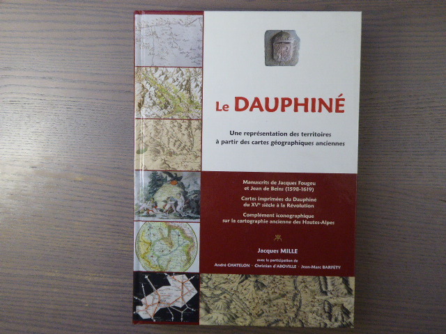
MILLE Jacques - CHATELON André - D'ABOVILLE Christian - BARFETY
LE DAUPHINE. Une représentation des territoires à partir des cartes géographiques anciennes.
Naturalia Publications S.L. 2013 In-4 ( 305 X 215 mm ) de 334 pages, cartonnage à la bradel illustré en couleurs. Superbe et abondante iconographie en couleurs et en noir dans et hors-texte. Le "Maître-Livre" sur le sujet. Ouvrage neuf.Le premier volet concerne la cartographie manuscrite exhaustive du Dauphiné ( 1598-1619 ) par Jacques FOUGEU et Jean de BEINS, à partir d une trentaine de documents exceptionnels de la British Library, de la Bibliothèque nationale de France et de fonds privés. Le deuxième volet est constitué d un catalogue raisonné d une centaine de cartes imprimées du Dauphiné du XVe siècle à la Révolution. Le troisième, quant à lui, est consacré aux Hautes-Alpes pour compléter et prolonger jusqu au XXe siècle, avec près de cent vingt reproductions, la représentation cartographique du département déjà réalisée dans le premier ouvrage consacré à ce thème. Ce sont ainsi près de trois cents reproductions de cartes anciennes, manuscrites et imprimées, essentiellement en couleurs, issues de fonds privés et d institutions diverses, qui sont exposées dans cet ouvrage. Le livre se présente comme un triptyque prolongeant l ouvrage publié par l auteur en 2011 : Les Hautes-Alpes. Cartes géographiques anciennes ( XVe-mi XIXe siècle ).
Bookseller reference : 893228
|
|
|
MILLE Jacques. CHATELON André. D'ABBOVILLE Gérard. BARFETY Jean Marc.
LE DAUPHINE, Une représentation des territoiresà partir des cartes géographiques anciennes. ( Manuscrits de Jacques Fougeu et Jean de Beins, cartes imprimées du Dauphiné du XVème siècle à la Révolution, Complément iconographiques sur a cartographie ancienne des Hautes Alpes).
1833 1833 1 volume in 8. 335 pages. très abondamment illustré. 2013. Etat neuf.
Bookseller reference : 2487

|
|
|
MILLION Claude
La topographie.
Couverture souple. Broché. 128 pages. Rousseurs.
Bookseller reference : 127113

|
|
|
Millo, Antonio
Der Weltatlas des Antonio Millo von 1586. ? Portolan Atlas.
Süssen, Deuschle, 1988. 1 Atlas (30 Bl.) mehrfarbige Karten Kommentarband (102 S.). Orig.-Leinenkassette und Leinenband. + Wichtig: Für unsere Kunden in der EU erfolgt der Versand alle 14 Tage verzollt ab Deutschland / Postbank-Konto in Deutschland vorhanden +, A|B (Faksimileausgabe).
Bookseller reference : 6977CB

|
|
 Receive by email
 Download as PDF document
 RSS feed


