|
|
|
MUNSTER, SEBASTIAN.
Italie.
Dalla “Cosmographiae Universalis”, Basilea, 1550 circa. Silografia, b/n, cm 20 x 30 (il foglio). Edizione tedesca con testo e quadro inciso su entrambi i lati del foglio (al verso, in un più piccolo quadro, una Italia spoglia ma intera con segnalate le principali città). La carta è rappresentata con il nord orientato in basso, nella classica rappresentazione tipica della scuola tedesca dell'inizio del XVI secolo. Sebastian Munster (1488 – 1552). Uniforme ingiallimento del foglio con traccia di nastro adesivo al centro del margine inferiore e una piccola mancanza all'angolo inferiore destro. In più che accettabile stato di conservazione.

|
|
|
MUNSTER, SEBASTIAN.
Sardinia Insula.
Basilea, 1550 circa. Xilografia, b/n, cm 21 x 32,3 (il foglio). Dalla “Cosmographiae Universalis” (lib. VI – Basileae, Henrichum Petri, 1550), la pag. 274 dell’atlante, come riportato in alto a sinistra, al margine bianco superiore. Edizione latina incisa da H. Petri, con riquadro figurato (cervo o muflone) al verso del foglio. Si vede la punta meridionale della Corsica con segnalata Bonifacio. Il disegno dell'isola, il cui titolo è inserito in un nastro svolazzante che la abbraccia, mostra una semiologia elementare; i rilievi sono rappresentati da vedute prospettiche di mucchi di talpa allineati a catena; i fiumi da un tratto forte; il mare da un tratteggio ondulato con strisce bianche e nere alternate; la vegetazione è simboleggiata da gruppi di alberelli, mentre i centri abitati sono segnalati da prospettini di case e torri. Sebastian Munster (1488 – 1552). Impressione leggermente stanca con lievi tracce di ingiallimento che però non disturbano l’esemplare. Foglio con due leggere pieghe trasversali ma in buono stato di conservazione.

|
|
|
MUNSTER, SEBASTIAN.
Sardinia Insula.
Basilea, 1550 circa. Xilografia, b/n, cm 20 x 30 (il foglio). Dalla “Cosmographiae Universalis” (lib. VI – Basileae, Henrichum Petri, 1550). Edizione tedesca con riquadro figurato (la città di Napoli vittima di catastrofe) al verso del foglio. Si vede la punta meridionale della Corsica con segnalata Bonifacio. Il disegno dell'isola, il cui titolo è inserito in un nastro svolazzante che la abbraccia, mostra una semiologia elementare; i rilievi sono rappresentati da vedute prospettiche di mucchi di talpa allineati a catena; i fiumi da un tratto forte; il mare da un tratteggio ondulato con strisce bianche e nere alternate; la vegetazione è simboleggiata da gruppi di alberelli, mentre i centri abitati sono segnalati da prospettini di case e torri. Sebastian Munster (1488 – 1552). Foglio con alcune gualciture, discreto stato di conservazione.

|
|
|
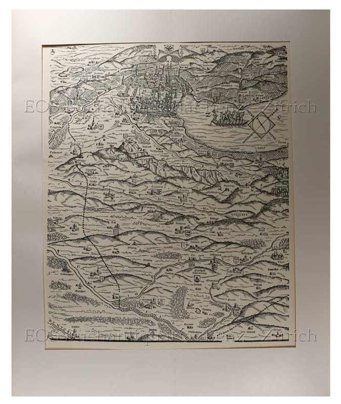
Murer, Jos
Karte des Kantons Zürich 1566.
Zürich., Matthieu., 1967. 58 x 48 cm. 6 Holzschnitte und 10 Bordürenteile. In Originalmappe. + Wichtig: Für unsere Kunden in der EU erfolgt der Versand alle 14 Tage verzollt ab Deutschland / Postbank-Konto in Deutschland vorhanden +, bild
Bookseller reference : 2427DB

|
|
|
Murer, Jos;
Karte des Kantons Zürich 1566.
Zürich. Matthieu. 1967 58 x 48 cm. 6 Holzschnitte und 10 Bordürenteile. In Originalmappe.
Bookseller reference : 2427DB
|
|
|
Murray Hugh; Revised by Thomas G. Bradford
The Encyclopaedia Encyclopedia of Geography. with a New Map of the United States Revised with Additions by Thomas G. Bradford 3 volumes with hand-colored map
Philadelphia: Lea and Blanchard 1846. PHOTOS UPON REQUEST. 3 volumes complete. Very Good condition. Bound in the publisher's brown cloth lettered in shiny gold on the spine. All gilt is as bright and shiny as new. A very nice set -- solid clean square and tight. Inner hinges are perfect. Corners are NOT bumped. Moderate rubbing/fraying to spine ends. Previous owner's name. A few small brown speckles foxing on the endpapers. Text pages are clean and crisp with little or no foxing. NO underlining. NO highlighting. NO margin notes. This 1846 edition is largely a reprint of the edition first published in 1837 which was copyright 1836. The only apparent change here is a 24-page addition to vol. 3 entitled: SUPPLEMENT TO THE ENCYCLOPAEDIA OF GEOGRAPHY CONTAINING STATISTICAL AND OTHER MATTER BRINGING DOWN THE WORK TO THE YEAR 1842." Among other things the supplement includes county-by-county population records from the 1840 census plus updated statistics on agriculture steam power imports/exports etc. Based on paginations found in Sabin this supplement was probably first published in 1843. The set is well-illustrated with 82 maps and about 1100 other engravings on wood. There are sections on astronomy by William Wallace botany by William Jackson Hooker geology by Robert Jameson and zoology by William Swainson. Volume III has a nice 2-page multi-color steel-engraved map of the U.S. It was drawn by J. Drayten after Tanner and features neatly hand-colored borders around each state and territory. Index Index to Supplement. Subtitle: "Comprising a Complete Description of the Earth Physical Statistical Civil and Political; Exhibiting Its Relation to the Heavenly Bodies Its Physical Structure The Natural History of Each Country and the Industry Commerce Political Institutions and Civil and Social State of All Nations." Oversize Hardcover. This heavy 3 volume set will require extra postage for Priority and International shipments. But for media mail you pay only our standard charge for 1 volume and we ship the other 2 volumes at no extra cost. Sabin 51499. New Edition with Supplement. Oversize Hardcover heavy. Very Good condition. Illus. by Drayten J hand-colored steel-engraved map of the U.S. 8vo. 597 592 648 pages. Great Packaging Fast Shipping. Lea and Blanchard Hardcover
Bookseller reference : 008628
|
|
|
MUSSINI Maria Luisa, MURARO Monica
ANTICHI CASELLI NELLA PROVINCIA DI REGGIO EMILIA.
In-8 (cm. 28), brossura muta, sovracoperta editoriale illustrata, pp. 271, (1), con illustrazioni in bianco e nero nel testo. Allo stato di nuovo (brand new copy).
|
|
|
MUSTAFA ÖNDER.
From past to present illustrated history of Turkish cartography.= Geçmisten günümüze resimlerle Türk haritacilik tarihi. Translated by Bülent Koç, Cemil Sökün.
New English Paperback. Oblong 4to. (21 x 30 cm). In English and Turkish. 392 p., color and b/w ills. From past to present illustrated history of Turkish cartography.= Geçmisten günümüze resimlerle Türk haritacilik tarihi. Mostly military map makers and cartography.
|
|
|
MUZAFFER SERBETÇI.
Türkiye haritaciligi bibliyografyasi. 2 volumes set . Vol. 1. Kitaplar - tezler, (1800-2000). Vol. 2. Makaleler - bildiriler, (1924-2000).
Fine Turkish Paperback. Pbo. Roy. 8vo. (24 x 17 cm). In Turkish. 2 volumes set (76 p.; 230 p.). Türkiye haritaciligi bibliyografyasi. 2 volumes set . Vol. 1. Kitaplar - tezler, (1800-2000). Vol. 2. Makaleler - bildiriler, (1924-2000). Bibliography of Turkish cartography.
|
|
|
Muzzi Salvatore
Dizionario geografico universale. Compilato sulle migliori opere relative e giusta le più recenti divisioni politiche col vocabolario di que' nomi antichi geografici che hanno mutato radicalmente oggidì

|
|
|
MYRDAL JAN
VIAGGIO IN CINA, FOTOGRAFIE DI GUN KESSLE
numerosissime foto in bianco e nero e a colori
|
|
|
MYRIAM HARRY
La Vallée des Rois et des Reines (au pays de Toutankhamon).
Arthème Fayard et Cie éditeurs, 1925, exemplaire bibliothèque, in 12 broché, 251 pages, état d'usage : dos fatigué, coiffes frottées, coins cornés, papier jauni.
Bookseller reference : 7324
|
|
|
MYRIAM HARRY
Lîle de volupté.
Le livre de demain, Artheme Fayard et Cie editeurs, octobre 1925, etat d'usage, in8, 125 pages, 24 bois originaux de Pierre Falké.
Bookseller reference : 5413
|
|
|
Mystic River Historical Society
The Story of One Corner of Connecticut in Sixteen 16 Maps
Connecticut: Mystic River Historical Society Very Good condition. Cover soil. NO owner's name or bookplate. NO ink stamps. NO underlining. NO highlighting. NO margin notes. This undated portfolio has reproductions of 16 historic maps of Connecticut and vicinity. Most are single sheets although five measure 20" wide by 16" tall when unfolded. The maps are laid-in loose except for one which is printed on the front cover of the portfolio. Also included are 3 loose sheets of text that give background information on each map. Subtitle: A Bicentennial Project of the Mystic River Historical Society. The maps included are: Captain John Smith's Map of New England 1614; Map of Connecticut circa 1625; A Map of New England 1677; Connecticut and Parts Adjacent 1777; Old Homes and Homesites of Groton Connecticut; Benedict Arnold at New London 1781; Our Corner of Connecticut in 1833; Borough of Stonington in 1851; Our Corner of Connecticut in 1854; The Present-day Mystic Area in 1854; Groton Bank in 1868; Noank Poquonoc and Old Mystic in 1868; The Town of Stonington in 1868; Our Corner of Connecticut in 1868. Oversize Softcover. 10.5" wide by 14.5" tall This large book will require extra postage for Priority and International shipments but only the standard charge for media mail. . First Edition Thus presumed. Softcover portfolio. Very Good condition. Illus. by NOT a library discard. Oversize Softcover. Great Packaging Fast Shipping. Mystic River Historical Society Paperback
Bookseller reference : 008732
|
|
|
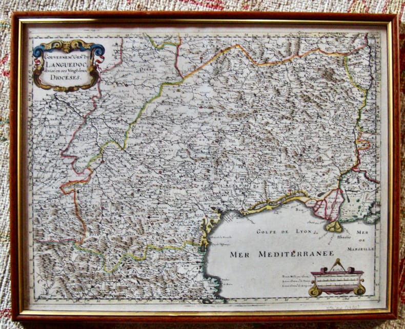
MÉRIAN
Gouvernement Général du Languedoc divisé en ses vingt deux diocèses.
Encadré Très bon 1650 31 x 39 cm avec le cadre.
Bookseller reference : 5997
|
|
|
Münster, Sebastian
Atlas Cosmographia, 1588. Cosmographey, oder Beschreibung aller Länder.
RARE LIMITED EDITION - COPY #95 OF 500. Reprint of a 16th century Atlas displaying maps of the four known continents: Europe, Africa, Asia and America. The book itself is a portfolio of 26 folded maps of various regions, complete with floral and figurative decoration. The book features a short preface in English, German and Dutch. 350x225mm. Unpaginated. Black cloth Hardcover with cloth straps. Cover slightly worn and slightly dirty. Rear cover edge bumped. Rear cover corners bent. Pages yellowing. [SUMMARY]: Save for some light external wear, this rare reprint of an historical atlas is in very good condition. PLEASE NOTE: This item is overweight. We may ask for extra shipping costs.
|
|
|
N. A.].
[MAP OF EAST & SOUTHEAST ANATOLIA AND CAUCASIA BORDERS] Erzurum, Van, Bitlis vilâyetleri ile bunlara civar olan Trabzon, Sivas, Harput ve Diyarbekir vilâyetlerinin bâzi kisâmi.
Very Good Turkish, Ottoman (1500-1928) Extremely rare huge chromo-lithograph map in 24 sheets mounted on canvas, showing a large zone including Midyat (Mardin), Mosul, Mt. Cilo (Resko-Buzul) on the southeast; Kahta (Adiyaman), Munzur Mt., Divrigi (Sivas) on the west; the Black Sea on north and Turkish borders to Armenia, Azerbaijan on the east, and to Russia on the northeast. In addition shows in separate little portions, roads, mountains and hills, lakes, and telegraph and post ways and borders in that zone. Not in any libraries and any collection. An attractive map with its huge size and decorative surface. Several toponyms are underlined in red ink. Otherwise a very good example. Original folded map mounted on canvas. 118x112 cm. In Ottoman script (Turkish with Arabic letters). Scale: 1/630.000.
|
|
|
N. A.].
[OTTOMAN MAP of CAUCASIA] [Eastern shores of Black Sea] Batum - Poti.
Very Good Turkish, Ottoman (1500-1928) Original color map. Elephant folio. (67 x 45 cm). In Ottoman script. Scale: 1/400.000. [OTTOMAN MAP of CAUCASIA] Shores of Black Sea / Batum - Poti. Shows Black Sea shores of Batum and Poti of Georgia. Mostly shown Black Sea in the map, but from southeast to northwest, a coastline reaches from Batum city to Adler (?). Some toponyms are in Turkish, but mostly Russian and Georgian in Arabic (Ottoman) script. A handsome and calligraphic Ottoman map.
|
|
|
N. A.].
[OTTOMAN MAP of CAUCASIA] Yekaterinodar - Yeysk - Maykob - Anapa.
Very Good Turkish, Ottoman (1500-1928) Original color map. Atlas folio. (55 x 46 cm). In Ottoman script. Scale: 1/400.000. [OTTOMAN MAP of CAUCASIA] Yekaterinodar - Yeysk - Maykob - Anapa. Shows Krasnodar, Maikop, Yeysk, Anapa and shores of Black Sea. At northeast, map shows Kuban river (Kuban nehri) and its basin in Circassia (Republic of Adygea). Maykop is the capital city of the Republic of Adygea in Russia, located on the right bank of the Belaya River (a tributary of the Kuban River). Yekaterinodar (Krasnodar) at north of map, near to Maykop. From northwest to south east, map shows Black Sea shores of the extensive area with interesting details in Ottoman Turkish script. Also shown Belaya, Chokhrak and Dakh Rivers in addition all south land of Krasnodar Krai of the Northwestern Caucasus until southern Georgian borders and Georgia. Almost all toponyms are in Ottoman Turkish.
|
|
|
N. A.].
[OTTOMAN MAP OF RHODES] Rodos.
Very Good Turkish, Ottoman (1500-1928) Original color map. Folded. Oblong atlas folio. (50 x 60 cm). In Ottoman script. Shows Rhodes and Tilos Islands. Scale: 1/200.000. Hegira: 1332 = Gregorian: 1916. Not description on map-maker. This is one of the series of the Bonn projection maps which are the first map series in modern techniques in Turkey and the Ottoman Empire. This is one of the series of the Bonn projection maps which are the first map series in modern techniques in Turkey and the Ottoman Empire. In order to produce these maps covering Turkish territory, Reconnaissance Branch was incorporated into The Mapping Commission. The maps were produced in the datum based on the latitude and longitude of Ayasofya Mosque in an equal area Bonn Projection. The field works for the 123 sheets covering the country were conducted by 76 staff. The production was completed in 18 years starting from east-west. Fieldworks continued without stopping except in the years 1914 and 1920. This map series called also reconnaissance maps contributed a lot to producing 1:25.000 scale maps. A very detailed and attractive map of Rhodes Island showing its harbors and Ottoman place names.
|
|
|
N. Pellati
Contribuzione alla storia della cartografia geologica in Italia
In 8 (cm 16,5 x 24,5), pp. 35 + (1b). Pagine intonse. Brossura editoriale. Estratto editoriale dagli Atti del Congresso internazionale di Scienze storiche (Roma, 1903). Saggio in cui Pellati, dopo avere fatto la storia della Cartografia geologica, presenta l'elenco cronologico delle carte geologiche o mineralogiche riguardanti il territorio italiano con i nomi degli autori. Importante repertorio bibliografico dedicato alla cartografia.
|
|
|
N.IORGA
Voyage en Roumanie (conférence donnée le 22 octobre 1921 à la Sorbonne).
Librairie Paul Suru, Bucarest, 1921, 69 pages, exmplaire de bibliothèque, brochure in 8, état d'usage, papier jauni, quelques rousseurs, légèrement insolé et défraichi.
Bookseller reference : 10192
|
|
|
n/a
Mercator. Reizen in het onbekende.
Paperback, 260x210mm, 124p, throughout colour illustrations, Dutch (NL) edition . ISBN 978908586628213. Het wereldbeeld van de Europeaan werd in de zestiende en zeventiende eeuw gevoelig uitgebreid, een nieuwe wereld ging open. Ontdekkingsreizigers, handelaars en diplomaten schreven hun reiservaringen neer in dagboeken en verslagen. Ze schetsten een beeld van recent ontdekte gebieden, waaruit we vandaag kunnen afleiden hoe toen naar andere culturen gekeken werd. De reisverhalen werden soms aangedikt met de nodige portie fantasie, maar gaven ook vaak een nauwkeurige beschrijving van exotische streken. Het waren belangrijke bronnen van informatie voor de cartografie, die bijgevolg een explosieve groei kende. Ook de kennis van de navigatie groeide aanzienlijk als gevolg van de verkenningsdrang van reizigers. De enorme maritieme expansie zorgde er immers voor dat er behoefte was aan nieuwe technieken en instrumenten om veilig en snel een bestemming te bereiken. De ontwikkeling van de cartografie, waarin Gerard Mercator een sleutelrol speelde, vergrootte op haar beurt de mobiliteit van de Europeaan. Het was voor de zestiende-eeuwse avontuurlijke reiziger niet ongewoon om voor een lange tijd op handelsmissie of studiereis te vertrekken. Een van die jonge avonturiers was Balthasar iii Moretus. Hij maakte meerdere reizen door Europa, onder meer naar Italie, en schreef zijn indrukken ervan in dagboeken neer. Mercator: Reizen in het onbekende brengt deze boeiende periode van wisselwerking tussen het reisgedrag van de Europeaan en de ontwikkeling van de cartografie letterlijk en figuurlijk in kaart.
|
|
|
N/A + BUVE A.
ANNALEN VAN DEN OUDHEIDKUNDIGEN KRING VAN HET LAND VAN WAAS.deel 64 (2e aflevering).
, Sint-Niklaas, 1960, Originele geillustreerde uitgeversomslag z/w, 17,5x27cm, 323 p. , geillustreerd z/w.
Bookseller reference : 20951
|
|
|
N/A + DE WILDE J.
ANNALEN VAN DEN OUDHEIDKUNDIGEN KRING VAN HET LAND VAN WAAS.deel 56 (2e aflevering).
, Sint-Niklaas, 1949, Originele geillustreerde uitgeversomslag z/w, 17,5x27cm, p. 89 t/m 171, geillustreerd z/w.
Bookseller reference : 20925
|
|
|
N/A + VAN GEERTSOM E.H.
ANNALEN VAN DEN OUDHEIDKUNDIGEN KRING VAN HET LAND VAN WAAS.deel 64 (2 e aflevering).
, Sint-Niklaas, 1961, Gebrocheerd, originele geillustreerde uitgeversomslag z/w, 17,5x27cm, p. 121 t/m p. 323, geillustreerd z/w.
Bookseller reference : 20950
|
|
|
N/A + VAN GOETHEM R.
ANNALEN VAN DEN OUDHEIDKUNDIGEN KRING VAN HET LAND VAN WAAS.deel 65 (1e aflevering).
, Sint-Niklaas, 1961, Originele geillustreerde uitgeversomslag z/w, 17,5x27cm, 168 p. geillustreerd z/w.
Bookseller reference : 20952
|
|
|
N/A + VAN GOETHEM R.
ANNALEN VAN DEN OUDHEIDKUNDIGEN KRING VAN HET LAND VAN WAAS.deel 65 (2e aflevering).
, Sint-Niklaas, 1962, Originele geillustreerde uitgeversomslag z/w, 17,5x27cm, 168 p. geillustreerd z/w.
Bookseller reference : 20954
|
|
|
N/A.
ANNALEN VAN DE KONINKLIJKE OUDHEIDKUNDIGE KRING VAN HET LAND VAN WAAS.deel 85,
, Sint-Niklaas, 1982.**, Originele geillustreerde uitgeversomslag z/w, 17,5x27cm, 190pp, geillustreerd in kleur en z/w.
Bookseller reference : 11058
|
|
|
N/A.
ANNALEN VAN DE KONINKLIJKE OUDHEIDKUNDIGE KRING VAN HET LAND VAN WAAS. Deel 76,
, Sint-Niklaas, 1973.**, Originele geillustreerde uitgeversomslag z/w, 17,5x27cm, 185 - 322pp, geillustreerd z/w.
Bookseller reference : 11064
|
|
|
N/A.
ANNALEN VAN DE KONINKLIJKE OUDHEIDKUNDIGE KRING VAN HET LAND VAN WAAS.deel 88,
, Sint-Niklaas, 1985.**, Originele geillustreerde uitgeversomslag z/w, 16x24cm, 319pp, geillustreerd z/w.
Bookseller reference : 11068
|
|
|
N/A.
ANNALEN VAN DE KONINKLIJKE OUDHEIDKUNDIGE KRING VAN HET LAND VAN WAAS. Deel 91,
, Sint-Niklaas, 1988.**, Originele geillustreerde uitgeversomslag z/w, 16x24cm, 349pp, geillustreerd z/w.
Bookseller reference : 11071
|
|
|
N/A.
ANNALEN VAN DE KONINKLIJKE OUDHEIDKUNDIGE KRING VAN HET LAND VAN WAAS.deel 92,
, Sint-Niklaas, 1989.(db)**, Originele geillustreerde uitgeversomslag z/w, 16x24cm, 319pp, geillustreerd z/w.
Bookseller reference : 11072
|
|
|
N/A.
ANNALEN VAN DE KONINKLIJKE OUDHEIDKUNDIGE KRING VAN HET LAND VAN WAAS.deel 96/1,
, Sint-Niklaas, 1993.**, Originele geillustreerde uitgeversomslag z/w, 16x24cm, 247pp, geillustreerd z/w.
Bookseller reference : 11076
|
|
|
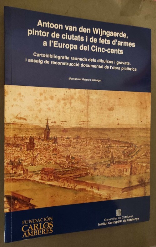
N/A.
Antoon van den Wijngaerde, pintor de ciutats i de fets d'armes a l'Europa del Cinc-cents. Cartobibliografia raonada dels dibuixos i gravats, i assaig de reconstrucció documental de l'obra pictòrica.
Institut Cartografic de Catalunya/Fundacion Carlos Amberes, 1998. grand in-4°, 264 pages, nombreuses illustrations, broché.
Bookseller reference : 81163
|
|
|
N/A.
Antoon van den Wijngaerde, pintor de ciutats i de fets d'armes a l'Europa del Cinc-cents. Cartobibliografia raonada dels dibuixos i gravats, i assaig de reconstrucció documental de l'obra pictòrica.
grand in-4°, 264 pages, nombreuses illustrations, broché. Très bel exemplaire - VG+++. [BD-E]
|
|
|
N/A.
Atlas. Geschiedenis, wetenschap en beeldende kunst.
Turnhout, Warande, 1990 Hardcover, 92pp., 24.5x34.5cm., ills. in kleur en z/w., goede staat.
Bookseller reference : 37327
|
|
|
N/A.
Atlas. Geschiedenis, wetenschap en beeldende kunst.
Hardcover, 92pp., 24.5x34.5cm., ills. in kleur en z/w., goede staat.

|
|
|
N/A.
BIJDRAGEN TOT DE GESCHIEDENIS BIJZONDERLIJK VAN HET OUD HERTOGDOM BRABANT. Jaargang 42, 3de reeks, 11de deel: aflevering 3
, Antwerpen, 1959., Originele geillustreerde uitgeversomslag z/w, 16x24cm, 113 - 176pp.
Bookseller reference : 10917
|
|
|
N/A.
BIJDRAGEN TOT DE GESCHIEDENIS BIJZONDERLIJK VAN HET OUD HERTOGDOM BRABANT. Jaargang 42, 3de reeks, 11de deel: aflevering 4.
, Antwerpen, 1959., originele geillustreerde uitgeversomslag z/w, 16x24cm, 177 - 243pp.
Bookseller reference : 6102
|
|
|
N/A.
BIJDRAGEN TOT DE GESCHIEDENIS BIJZONDERLIJK VAN HET OUD HERTOGDOM BRABANT. Jaargang 43, 3de reeks, 12de deel: aflevering 4.
, Antwerpen, 1960., Originele geillustreerde uitgeversomslag z/w, 16x24cm, 309 - 340pp.
Bookseller reference : 6608
|
|
|
N/A.
BIJDRAGEN TOT DE GESCHIEDENIS BIJZONDERLIJK VAN HET OUD HERTOGDOM BRABANT. Jaargang 46, 3de reeks, 15de deel: aflevering 3 - 4
, Antwerpen, 1963., originele geillustreerde uitgeversomslag z/w, 16x24cm, 139 - 232pp.
Bookseller reference : 9206
|
|
|
N/A.
BIJDRAGEN TOT DE GESCHIEDENIS BIJZONDERLIJK VAN HET OUD HERTOGDOM BRABANT. Jaargang 44, 3de reeks, 13de deel: aflevering 4
, Antwerpen, 1961., originele geillustreerde uitgeversomslag z/w, 16x24cm, 147 - 192pp.
Bookseller reference : 9359
|
|
|
N/A.
HANDELINGEN DER MAATSCHAPPIJ VOOR GESCHIEDENIS EN OUDHEIDKUNDE TE GENT.; XLIV,
, Gent, 1990 (5db)., Originele geillustreerde uitgeversomslag z/w, 16x24,5cm, 203pp.
Bookseller reference : 2868
|
|
|
N/A.
HANDELINGEN DER MAATSCHAPPIJ VOOR GESCHIEDENIS EN OUDHEIDKUNDE TE GENT. XLIII, 1989,
, Gent, 1989 (db)., Originele geillustreerde uitgeversomslag z/w, 16x24,5cm, 271pp.
Bookseller reference : 6446
|
|
|
N/A.
La Découverte du monde : Cartographes et Cosmographes.
grand in-8 (19 x 24 cm), 88 pages, nombreuses illustrations, broché.. Bel exemplaire. [WE-CA]
|
|
|
N/A.
Mapping Cyprus. Crusaders, Traders and Explorers. Kruisvaarders, handelaars en ontdekkinsreizigers. Croises, marchands et explorateurs.
Brussels, Silvana - Bozar Books, 2012 Paperback, 287x230mm, 240p, 120 colour illustrations, English/ French/ Dutch edition. New. ISBN 9788836623709.
Bookseller reference : 36375
|
|
|
N/A.
Mapping Cyprus. Crusaders, Traders and Explorers. Kruisvaarders, handelaars en ontdekkinsreizigers. Croises, marchands et explorateurs.
Paperback, 287x230mm, 240p, 120 colour illustrations, English/ French/ Dutch edition. New. ISBN 9788836623709. Chypre se situe a l'extreme est de la mer Mediterranee, au carrefour de trois continents : l'Europe, l'Asie et l'Afrique. Autrefois, l'ile etait a la fois une pomme de discorde et un refuge pour l'Est byzantin, l'Occident latin et le monde arabe. Apres sa conquete par Richard Coeur de Lion, les Lusignans, les Venitiens, les Ottomans et les Britanniques se sont succede au pouvoir. Mapping Cyprus (1192-2012) se penche sur l'ile tant convoitee de Chypre a travers les yeux des artistes, ecrivains, pelerins et voyageurs europeens. Notamment la periode franque de Lusignan pendant les croisades est illustree par des personnages de legende comme la princesse Melusine. C'est l'illumination d'un episode de l'histoire de l'Europe qui frappe les imaginations et qui etait aussi determinante pour l'identite de Chypre, entree en 2004 dans l'Union europeenne et qui en assumera la Presidence en 2012. Musique, mots, multimedia et art contemporain donnent vie a une suite d'icones et autres tresors artistiques. L'exposition explore cette plaque tournante des cultures, avec tous les conflits et echanges qui la caracterisent. Le present de l'ile divisee est egalement mis sous les projecteurs. Cyprus ligt in de uiterst oostelijke uithoek van de Middellandse Zee. Drie continenten komen er samen: Europa, Azie en Afrika. Het eiland vormde een twistappel en een toevluchtsoord voor het Byzantijnse Oosten, het Latijnse Westen en de Arabische wereld. Na de verovering door Richard Leeuwenhart hadden de Lusignans, Venetianen, Ottomanen en Britten afwisselend de macht in handen. Mapping Cyprus (1192- 2012) bekijkt de begeerde bruid Cyprus door de ogen van Europese kunstenaars, schrijvers, pelgrims en reizigers. Vooral de Frankische Lusignan periode ten tijde van de kruisvaarders wordt belicht, met fabelachtige figuren als de prinses Melusine. Een illuminatie dus van een tot de verbeelding sprekend stukje Europese geschiedenis en sterk bepalend voor de identiteit van Cyprus dat in 2004 toetrad tot de Europese Unie en in 2012 het Voorzitterschap op zich neemt. Een reeks iconen en andere kunstschatten komt tot leven in samenspraak met muziek, woord, multimedia en hedendaagse kunst. De tentoonstelling dringt diep door in het knooppunt van culturen, met alle conflicten en uitwisselingen van dien. Tegelijk komt het heden van dit verdeelde eiland in het vizier. Cyprus is situated in the far eastern extremity of the Mediterranean Sea, where the three continents of Europe, Asia, and Africa are neighbours. The island has been both a bone of contention and a place of refuge for the Byzantine East, the Latin West, and the Arab world. After its conquest by Richard the Lionheart, power there was held at different times by the Lusignan dynasty, the Venetians, the Ottomans, and the British. Mapping Cyprus (1192-2012) looks at the coveted land of Cyprus through the eyes of European artists, writers, pilgrims, and travellers. Above all light is shed on the Frankish Lusignan period at the time of the crusaders and such fabled figures as Princess Melusyne.An illumination therefore of an evocative period of European history that was very determining for the identity of Cyprus that joined the European Union in 2004 and will be holding the EU presidency in 2012. A series of icons and other art treasures are brought to life in a dialogue with music, words, multimedia presentations, and contemporary art. The exhibition takes an in-depth look at this crossroads of cultures and at the conflicts and exchanges that have shaped it, while also focusing on today's divided island.

|
|
|
N/A;
ANNALEN VAN DE KONINKLIJKE OUDHEIDKUNDIGE KRING VAN HET LAND VAN WAAS. deel 95,
, Sint-Niklaas, 1992, Originele geillustreerde uitgeversomslag z/w, 16x24cm, 320pp, geillustreerd z/w.
Bookseller reference : 11075
|
|
|
N/A;
BIJDRAGEN TOT DE GESCHIEDENIS BIJZONDERLIJK VAN HET OUD HERTOGDOM BRABANT, Reeks III Jaar III nrs 1 t:m 4 jaar 1952
Antwerpen, Bijdragen tot de geschiedenis, 1952 Originele geillustreerde uitgeversomslag, 16x24cm, 254pp.
Bookseller reference : 46460
|
|
|
 Receive by email
 Download as PDF document
 RSS feed


