|
Heydemann, Berndt/Jutta Müler-Karch
Biologischer Atlas Schleswig-Holstein. Lebensgemeinschaften des Landes.
Neumünster, Wachholtz, 1980. 34 cm. (8), 263 S. mit 51 Textabb., 54 Farbtafeln mit 256 Abb. Original Leinen (Hardcover). Gutes Exemplar. Im Original-Schutzschuber, dieser am Fuß eingerissen.
Bookseller reference : 17069AB

|
|
|
HF. Mark SM. Atlas & ECernia Eds H. F. S. M. E. Ce
Man-Made Fibers: Science and Technology Volume 1
CBS Publishers & Distributors Pvt. Ltd. 2011. Softcover. New. Printed Pages: 448. CBS Publishers & Distributors Pvt. Ltd. paperback
Bookseller reference : 89694 ISBN : 8126532645 9788126532643
|
|
|
HF. Mark SM. Atlas & ECernia Eds H. F. S. M. E. Ce
Man-Made Fibers: Science and Technology Volume 1
CBS Publishers & Distributors Pvt. Ltd. 2011. Softcover. New. Printed Pages: 448. CBS Publishers & Distributors Pvt. Ltd. paperback
Bookseller reference : 89694
|
|
|
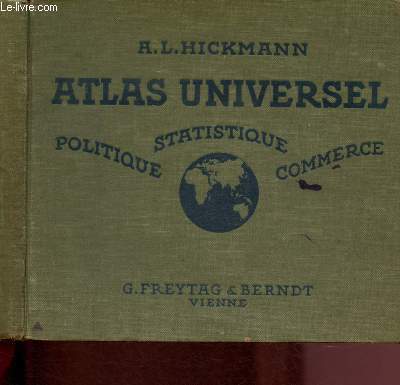
Hickmann A.L., Fischer Louis
Atlas universel : politique, statistique, commerce
G. Freytag & Berndt. Non daté. In-8. Relié toilé. Etat d'usage, Tâchée, Dos satisfaisant, Papier jauni. 79 pages augmentées de nombreuses cartes et illustrations en couleurs, dans et hors texte. Rousseurs. Manque en coin en page de titre et page de garde n'altérant pas la lecture. Vendu en l'état.. . . A l'italienne. Classification Dewey : 912-Atlas, cartes et plans
Bookseller reference : R200099864
|
|
|
Hickmann, A.L
Geographischer-statistischer Universal-Taschen-Atlas. Ausgabe 1897.
Wien, Freytag und Berndt, (1897). 63 (1) SS., 48 doppelseitige, mehrfarbige, lithographische Tafeln. 8° (ca. 10 x 17,5 cm), illustr. orig.- Leinwand.
Bookseller reference : 21174
|
|
|
Hiestand, L.A.
Western Canadian Motor - A Journal for the Automotive Trade - July 1930
32 pages. Features: Profitable Electric Service (conclusion) - the Layout of the Wilson Electric Service; Undercutting Mica on Armature Commutators; Correct Methods of Brake Relining - how to insure a satisfactory job; Wiring Diagrams - International Trucks; Shop and Showroom; Studebaker introduces Free Wheeling Principle - article with photos; Short Cuts for Handy Mechanics; Modern Equipment - Atlas makes new super service equipment; Modern Car Loading; Complete Mechanical Details of the American Austin; Passenger Car Prices F.O.B. Vancouver; Truck Prices F.O.B. Vancouver; Passenger Car Specifications for Engine, Pistons, Rings, Rods, Valves, Lubrication, Cooling, Clutch, Axles, Brakes, Steering, Springs, Crankshaft Bearings, Crankshaft Bearings, Camshaft, Electrical, Fuel; Photo of the Vernon Garage; Photo of the Beausejour Auto and Marine Shop; Nice Canada Cement Concrete ad inside back cover includes photos of the Fleet St. retaining wall near John St., Toronto and two other Toronto structures; Great vintage ads. Average wear and soiling. Binding intact. A sound vintage copy. Magazine

|
|
|
HIGOUNET CH. - MARQUETTE J.-B. - WOLFF PH.
ATLAS HISTORIQUE DES VILLES DE FRANCE - BAZAS
CNRS. 1982. In-Folio. Broché. Etat d'usage, Couv. convenable, Dos satisfaisant, Intérieur frais. Chemise cartonnée souple à 3 rabats contenant 1 document de 3 pages + 1 plan en couleurs de la ville avec une legendes explicative à part.. . . . Classification Dewey : 912-Atlas, cartes et plans
Bookseller reference : RO20178538
|
|
|
Higham Jon Atlas
Aardvark's Picnic Picturemacs
Macmillan Children's Books. Used - Very Good. Ships from the UK. Former Library book. Great condition for a used book! Minimal wear. 100% Money Back Guarantee. Your purchase also supports literacy charities. Macmillan Children's Books unknown
Bookseller reference : GRP98623993 ISBN : 0333491157 9780333491157
|
|
|
Higham Joh Higham Jon Atlas
Aardvark's Picnic
Little Brown & Co Juv 5/1/1987. Hardcover. Acceptable. 0.4000 inches 9.9000 inches 7.9000 inches. Ex-library hardcover with stickers on spine and back stamp inside cover and pocket inside back cover. Light surface wear from age. Otherwise fully intact and in good overall condition. Little Brown & Co (Juv) hardcover
Bookseller reference : mon0000099899
|
|
|
Higham Jon Atlas
Aardvarks Picnic Picturemacs
Macmillan Childrens Books 04/01/1989. New edition. Paperback. Used; Good. Yellow Pages due to Age. Stains on Side WE SHIP WITHIN 24 HRS FROM LONDON UK 98% OF OUR ORDERS ARE RECEIVED WITHIN 7-10 DAYS. We believe you will be completely satisfied with our quick and reliable service. All orders are dispatched as swiftly as possible! Buy with confidence! Macmillan Childrens Books paperback
Bookseller reference : 3705297 ISBN : 0333491157 9780333491157
|
|
|
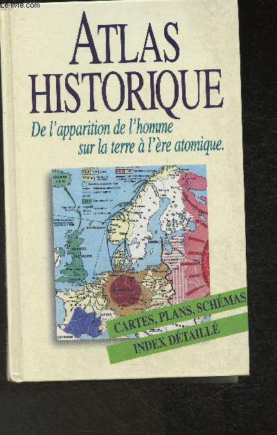
HILGEMANN WERNER & KINDER HERMANN
ATLAS HISTORIQUE DE L'APPARITION DE L'HOMME SUR LA TERER A L'ERE ATOMIQUE .
FRANCE LOISIRS /PERRIN. 1997. In-8. Relié. Bon état, Couv. convenable, Dos satisfaisant, Intérieur frais. 668 pages - nombreuses cartes en couleurs hors texte - textes sur deux colonnes.. . . . Classification Dewey : 912-Atlas, cartes et plans
Bookseller reference : R240105936
|
|
|
Hilgemann Werner, Kinder Hermann
Atlas historique-: De l'apparition de l'homme sur la Terre à l'ère atomique
France Loisirs/Librairie Académique Perrin. 1997. In-8. Cartonné. Bon état, Couv. convenable, Dos satisfaisant, Intérieur frais. 668 pages. Nombreuses illustrations en noir et blanc et en couleur, dans et hors texte.. . . . Classification Dewey : 912-Atlas, cartes et plans
Bookseller reference : RO30314809
|
|
|
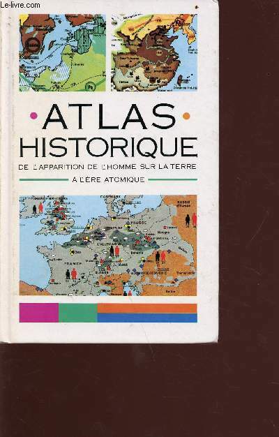
Hilgemann W./Kinder H.
Atlas historique de l'apparition de l'homme sur la terre à l'ère atomique
France Loisirs/librairie académique Perrin. 1993. In-12. Broché. Etat d'usage, Couv. légèrement passée, Dos satisfaisant, Intérieur frais. 652 pages - nombreuses cartes et illustrations en couleur et noir et blanc dans et hors texte - texte sur 2 colonnes - 2e plat légèrement tâchée. . . . Classification Dewey : 912-Atlas, cartes et plans
Bookseller reference : R160213445
|
|
|
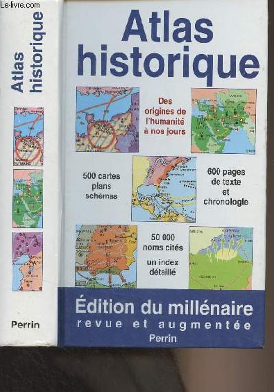
Hilgemann Werner/Kinder Hermann
Atlas historique - De l'apparition de l'homme sur la terre à l'ère atomique (Edition du milléraire)
Perrin. 2000. In-12. Relié. Bon état, Couv. convenable, Dos satisfaisant, Intérieur frais. 670 pages - nombreuses cartes en couleurs et quelques unes en noir et blanc hors texte. Texte sur deux colonnes. Petite annotation à l'encre en page de garde.. . . . Classification Dewey : 912-Atlas, cartes et plans
Bookseller reference : R300295595
|
|
|
Hilgemann, Werner (Verfasser) und Jürgen (Verfasser) Taufmann
Atlas zur deutschen Zeitgeschichte 1918 - 1968. [1. - 8. Tsd.]
München ; Zürich : Piper, 1984. 207 S. : zahlr. Kt. OPp., gebundene Ausgabe.
Bookseller reference : 177331

|
|
|
Hilgemann, Werner und Jürgen Taufmann
Atlas zur deutschen Zeitgeschichte 1918 - 1968. Kartografie: Jürgen Taufmann. Unter Mitarbeit von Christiane u. Irene Hilgemann ...
München ; Zürich : Piper, 1984. Originalausgabe; [1. - 15. Tausend]; 408 S. mit zahlreichen Abbildungen und Karten ; 19 cm; Orig.-Broschur;
Bookseller reference : 113575

|
|
|
Hiller, Konrad
Grosser Atlas der Welt - Die Erde im neuen Kartenbild
Berlin, Gütersloh, Stuttgart, München, RV Reise- und Verkehrsverlag GmbH, 1985. Lizenzausgabe 304 Seiten , 36 cm, Hardcover/Pappeinband
Bookseller reference : 41176

|
|
|
Hintnaus, Jaroslav
Bildatlas der Haus- und Hoftiere
München: Mosaik Verlag, 1988. 303 S. ; 28 x 21,5 cm ; Leinen.
Bookseller reference : 131662

|
|
|
Hirtz Christian-Bernard
Atlas Historia de la Révolution
Tallandier 1990 In-4 relié. 119 pages. Très bon état d’occasion.
Bookseller reference : 72174
|
|
|
Hirsch, Hans A. / Käser, Otto / Iklé, Franz A
Atlas of Gynecological Surgery. Including Breast Surgery and Related Urological and Intestinal Surgical Operations.
Stuttgart, New York, Georg Thieme Verlag, 1996. 4°; 307 pages, 1224 illustrations; [Englisch]; 2. Edition Orig.-Folienpappband kaum Gebrauchsspuren Thieme Classics
Bookseller reference : 35010

|
|
|
Hirsch, Martin Christian
InterBRAIN. Topographische Anatomie des ZNS des Menschen, voll interaktive 3D-Modelle, Windows-, Macintosh-CD-ROM. (= Springer-electronic-Media).
Berlin, Heidelberg, Springer, 1998. 1 CD-ROM : farb., mit Ton ; 12 cm, in Behältnis 27 x 19 x 3 cm + Beil. [2 Warenabbildungen]
Bookseller reference : 29877

|
|
|
HISTOIRE SUISSE (atlas) par H. AMMANN et K. SCHIB avec collaborateurs.
Atlas historique de la Suisse. Richement documenté (Très nombreuses planches en couleurs sur 67 pages).
Aarau, Verlag H.R. Sauerländer 1958. Bon exemplaire relié, gd in-4, (34x24), 36 pages de texte + 67 pages de cartes.
Bookseller reference : AUB-9252
|
|
|
Historical Atlas of Colorado Thomas J. Noel; Paul F. Mahoney and Richard E. Stevens Stevens
Historical Atlas of Colorado Thomas J. Noel; Paul F. Mahoney and Richard E
Fine. unknown
Bookseller reference : 1117
|
|
|
Historical Atlas Publishing Co
Historical Atlas of the County of Wellington Ontario. Compiled Drawn and Published From Personal Examinations and Surveys
Toronto: Historical Atlas Publishing Co 1906. Hardcover. Good . 70 p. interspersed with plates CXXI. 49 cm. 22 p. of b&w portraits and 121 p. of colour maps. Half leather black cloth. Writing on front chipped off. Respined and corners rebuilt. Stain on rear cover. New free endpapers and hinge repairs. Paper repairs to title page and other pages up to p. 9. Some dampstains thumbing and small tears. <br/><br/>Contains historical sketch and biographies as well as maps. Atlas section has maps of communities such as Guelph Elora Fergus Aberfoyle Erin Palmerston Mount Forest Harriston Arthur etc. as well as townships. Bonus section includes maps of the world continents countries and various provinces. Historical Atlas Publishing Co hardcover
Bookseller reference : 112114

|
|
|
Historical Atlas Publishing Co William F. E. Morley Ed.
Illustrated historical atlas of Wellington County Ontario
Belleville Ontario Canada: Mika Silk Screening 1972. Book. Near Fine. Hardcover. Facsimile. Elephant Folio - over 15 - 23" tall. 121 Pages Illus. Maps Family Histories. Facsimile Reprint Of Original 1906 Edition. Mika Silk Screening Hardcover
Bookseller reference : 036153 ISBN : 0919302270 9780919302273
|
|
|
Historischer und geographischer Atlas von Europa. Fischer, W./Streit, F.W. [Hrsg.]
Historischer und geographischer Atlas von Europa. Bd 1. (Textband 1 von 3).
Bln: Natorff 1834. (2 Bll.), 1009 S., lith. Titel. HLdr.d.Zt. *Der Kartenband erschien 1837*.
Bookseller reference : 280404
|
|
|
Hochstetter (Hrsg.), Prof. Dr. Ferdinand
Toldts Anatomischer Atlas für Studierende und Ärzte. Achtzehnte Auflage mit den Namen der neuen Nomenklatur
Berlin, Urban & Schwarzenberg, 1940. 343 S. 4° Quart, Halbleinen
Bookseller reference : 102540

|
|
|
HOFFMANN, Karl Friedrich Vollrath (Bearb.):
Atlas für Schulen und zum Selbstunterricht. 2., durchgesehene und vermehrte Auflage.
Stuttgart, (Carl Hoffmann für) J. Scheible’s Buchhandlung, 1835, in-4to oblong, hinterlegter blaufarb. Umschlag-Titelblatt + 18 Blätter Karten + 15 (von 16 Blätter Text (Textbl. für Nordamerika fehlt), etwas stockfleckig, Wasserfleck in beiden ausseren Ecken, schön und gross handgeschr. altdt. Besitzeintrag auf Vorsatz von ‘... Eugen Bertschinger ... 1836’, Halblederband mit Ecken, Buntpapier auf den Deckeln, leicht berieben.
Bookseller reference : 50230aaf
|
|
|
Hofmann Bernard
Cahiers archéologique n°3- 100 cartes commentées pour servir à l'histoire de la Gaule Antique
Centre de recherches archéologiques du Vexin Français. 1982. In-12. Broché. Etat d'usage, Coins frottés, Dos fané, Papier jauni. 58 pages de 100 cartes en noir et blanc. Agrafes rouillées. Quelques rousseurs.. . . . Classification Dewey : 912-Atlas, cartes et plans
Bookseller reference : RO30375389
|
|
|
Hoffmann, Heinrich
Malerische Ansichten von Wiesbaden und Umgegend - Leporello HOFFMANN, H. (nach Original-Ölgemälden von Heinrich Hofmann)
Kunstverlag Edmund von König, Heidelberg. 12 farbige Kunstpostkarten als Leporello
Bookseller reference : 28462

|
|
|
Hoffmann, Karl/Dennert, Eberhard
Botanischer Bilderatlas. nach d. natürl. Pflanzensystem ; zugl. e. Flora zur Best. sämtl. in Deutschl. vorkommenden Pflanzen ; nach d. gegenw. Stande d. botanischen Wiss..
Stuttgart, Schweizerbart, 1911. 3. vollst. veränd. Aufl. 4. 272 S. : mit etwa 500 farb. Abb. auf 86 Taf. sowie 959 Textfiguren OL. Berieb. u. bestoss., Klebestr. a. Rü.-Gel., Schn. gebr. u. fl., Gel. gelock., innen stellenw. fl., insges. innen sauber erhalten. 3
Bookseller reference : 46866AB
|
|
|
Hoffmann, M,, F. Köhler H. Langer u. a
Haack Weltatlas
Gotha, Leipzig, VEB Hermann Haack, Geographisch-Kartographische Anstalt, 1987. 7. Auflage 361 Seiten , 35 cm, Leinen
Bookseller reference : 50977
|
|
|
Holmes Richard
Atals historique de la guerre- Les armes et les batailles qui ont changé le cours de l'histoire
Editions Jean-Claude Lattès/Hachette. 1989. In-4. Relié. Etat d'usage, Coins frottés, Dos satisfaisant, Fortes mouillures. 304 pages. Jaquette correcte. Deux colonnes de texte. Nombreuses illustrations et photos en noir et blanc et en couleurs, in et hors texte. Papier jauni.. Avec Jaquette. . . Classification Dewey : 912-Atlas, cartes et plans
Bookseller reference : RO30368334
|
|
|
HOLMES RICHARD
ATLAS HISTORIQUE DE LA GUERRE - LES ARMES ET LES BATAILLES QUI ONT CHANGE LE COURS DE L'HISTOIRE.
FRANCE LOISIRS. 1990. In-4. Relié. Bon état, Couv. convenable, Dos satisfaisant, Intérieur frais. 304 pages. Nombreuses illustrations en couleurs et en noir et blanc dans et hors texte. Jaquette en couleurs en bon état.. Avec Jaquette. . . Classification Dewey : 912-Atlas, cartes et plans
Bookseller reference : ROD0102486
|
|
|
Holmes Richard
Atlas historique de la guerre - les armes et les batailles qui ont changé le cours de l'histoire.
Jean-Claude Lattès - Hachette. 1989. In-4. Relié. Bon état, Couv. convenable, Dos satisfaisant, Intérieur frais. 304 pages - jaquette en bon état - nombreuses illustrations en couleurs et en noir et blanc dans le texte - nombreuses cartes en couleurs dans le texte - texte sur deux colonnes.. Avec Jaquette. . . Classification Dewey : 912-Atlas, cartes et plans
Bookseller reference : R160224040
|
|
|
Holmes Richard
Atlas historique de la Guerre les armes et les batailles qui ont changé le cours de l'histoire.
Jean-Claude Lattès - Hachette. 1989. In-4. Relié. Bon état, Couv. convenable, Dos satisfaisant, Intérieur frais. 304 pages - nombreuses illustrations, cartes en couleurs et en noir et blanc dans le texte - texte sur deux colonnes - jaquette en bon état.. Avec Jaquette. . . Classification Dewey : 912-Atlas, cartes et plans
Bookseller reference : R160226203
|
|
|
Holmes Richard
Atlas historique de la guerre. Les armes et les batailles qui ont changé le cours de l’histoire
Editions Jean-Claude Lattès 1989 In-8 cartonnage éditeur 30 cm sur 23,5. Jaquette en bon état. 303 pages. Bon état d’occasion.
Bookseller reference : 106782
|
|
|
Holland
Het veranderend gezicht van Noord-Holland. Beelden van dorpen en steden water en land uit de provinciale atlas.
Amsterdam, Meijer Pers B.V., 1976 26 x 32, 158 pp., très nombreuses illustrations couleurs + N/B, cartonnage + jaquette, emboîtage, très bon état
Bookseller reference : 2844
|
|
|
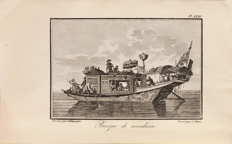
HOLMES, Samuel.
Voyage en Chine et en Tartarie, à la suite de l’ambassade de Lord Macartney, par M. Holmes, sergent-major de sa garde ; Auquel on a joint les Vues, Costumes, etc., de la Chine, par M. W. Alexandre, les Planches de l’Atlas original de cette Ambassade, omises dans la traduction française, et leur Explication… Edition originale de ce recueil de premières traductions françaises relatives à l’ambassade de Lord Macartney en Chine.
Bel exemplaire conservé tel que paru, broché et grand de marges car non rogné. Paris, Delance et Lesueur, 1805. 2 tomes en 2 volumes in-8 de I/ (2) ff., xlv pp., 171 pp., 25 gravures hors-texte dont 1 carte dépliante de Macao ; II/ (2) ff., 188 pp., 27 gravures dont 1 plan dépliant de la salle d’audience. Conservés brochés et non rognés, tels que parus, étiquettes de titre en tête des dos. Brochure de l’époque. 215 x 137 mm.
Bookseller reference : LCS-17836
|
|
|
Holenstein, Elmar
Philosophie-Atlas : Orte und Wege des Denkens. Elmar Holenstein 2. Aufl.
Zürich : Ammann 2004. 301 S. : Ill., graph. Darst. ; 30 cm, mit Schutzumschlag Pp., gebundene Ausgabe, Hardcover/Pappeinband, Exemplar in sehr gutem Erhaltungszustand, Neupreis in Euro: 43,90
Bookseller reference : 33814

|
|
|
HOLSTER ATLAS
The American Military Pocket Atlas; being an Approved Collection of Correct Maps both General and Particular of the British Colonies; Especially those which now are or probably may be the Theatre of War:.
London: R. Sayer and J. Bennet 1776. 8vo. 8 6/8 x 5 4/8 inches. 6 EXCEPTIONALLY FINE folding engraved maps with original hand-colour in outline some minor offsetting. Contemporary calf backed marbled paper boards the spine with six compartments with five raised bands red morocco lettering-piece in one the others with gilt-ruled borders. Provenance: bookplate removed from front paste-down First edition of the "HOLSTER ATLAS" and AN ATTRACTIVE COPY. Designed by its publishers Sayer and Bennett successors to Thomas Jefferys for British use in the field during the American Revolution "a portable atlas.calculated in its bulk and price to suit the pockets of officers of all rank." However since the atlas was mostly stowed in their holsters it became widely known as the "holster atlas." The maps are those "that the British high command regarded as providing essential topographical information in the most convenient form" Schwartz & Ehrenberg and include: "North America as divided amongst the European Powers" and "A Compleat Map of the The West Indies containing Coasts of Florida Louisiana New Spain and Terra Firma: with all the Islands" by Samuel Dunn; "A General Map of the Northern British Colonies in America. Which comprehends the Province of Quebec the Government of Newfoundland Nova-Scotia New England and New York" by Samuel Holland and Thomas Pownall 1776; "A General Map of the Middle British Colonies in America. Containing Virginia Maryland the Delaware counties Pennsylvania and New Jersey. With the addition of New York and of the Greatest Part of New England as also of the Bordering Parts of the Province of Quebec improved from several surveys made after the late War and Corrected from Governor Pownall's Late Map 1776" after Joshua Fry and Peter Jefferson and Lewis Evans central vertical fold strengthened with archival tissue; "A General Map of the Southern British Colonies in America comprehending North and South Carolina Georgia East and West Florida with the Neighbouring Indian Countries." after William de Brahm Henry Mouzon John Collett and Bernard Romans; and "A Survey of Lake Champlain including Lake George Crown Point and St. John" by William Brassier. Howes A208; Sabin 1147; Schwartz & Ehrenberg page 190; Streeter sale 73. Catalogued by Kate Hunter. London: R. Sayer and J. Bennet, [1776]. hardcover
Bookseller reference : 72lib318

|
|
|
Holtzwurm, Abraham
Archiducatus Austriae Superioris Vulgo Supra Anisum cognominatae Nova Descriptio. Altkolorierte Kupferstichkarte aus: Joan Blaeu, Le Grand Atlas.
Amsterdam, Joan Blaeu, 1667. Ca. 49 cm x 54 cm. [3 Warenabbildungen]
Bookseller reference : 17464

|
|
|
Holzner/Mathes
Atlas der Herzerkrankungen.
München Pharmazeutische Verl.-Ges. 1982. 240 S., m. Zeichnungen v. L. Metzenbauer u. Beiträgen von R. Rüdel u. J. Gehring. O.-Leinen, verg. Rü.-u. Deckeltit., O.-Umschl., i. Schuber. Neuwertig.
Bookseller reference : 37552AB
|
|
|
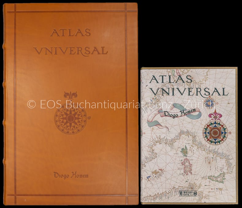
Homem, Diogo:
Atlas universal. – (Faks. der Ausg. der russischen Nationalbibliothek Sankt Petersburg von 1565).
2 Bände. Barcelona, Moleiro, 2000–2002. Folio und quart. 331 S. Mit (20) Bl. mit faks. Karten. Leinen- und Lederband in Lederbox.
Bookseller reference : 30664AB
|
|
|
HOMANN Jean-Baptiste / WITT Frédéric de / SEUTTER Matthieu (1678-1757) / & Alii
ATLAS : CARTES, PLANS ET VUES DU MONDE ENTIER. Colored Maps
XVII - XIX Nuremberg et Amsterdam principalement. Extrême fin XVIIème - début XIXème siècle. Format oblong in-Plano 54x64 cm. Recueil de cartes anciennes rassemblées et reliées au début du XIXème siècle. La majorité des cartes (COLOREES !) sont l'oeuvre de Frédéric de Witt d'Amsterdam et de Jean-Baptiste Homann (et ses héritiers) de Nuremberg (soit fin XVIIème - première moitié XVIIIème siècle). Des cartes non colorées et plus récentes d'origine française pour la plupart (seconde moitié du XVIIIème siècle et dans de rares cas début du XIXème siècle) ont été intercalées à la suite de chaque pays ou région. Cet ensemble exceptionnel représente ainsi 193 feuillets in-plano portant une ou plusieurs cartes, plans ou vues. Différentes numérotations à la plume laissent supposer que plusieurs ouvrages différents de moindre envergure ont servi à la constitution de cet ensemble imposant. Celui-ci se présente actuellement dans une reliure utilitaire en demi-parchemin à coins du XIXème siècle. Traces d'usage sur la reliure et poussière sur la tranche des cartes, quelques feuillets légèrement brunis, sinon contenu en bon état général.
Bookseller reference : 1863
|
|
|
HOMANN JOHANN BAPTIST. AN EARLY COMPLETE HOMANN ATLAS
Atlas Minor L. Selectorum Tabularum Homanni. Kleiner Atlas von F�nffzig Auserlesenen Homanns=Land=Karten Nach Anleitung der neuesten Erd=Beschreibere verbessert und eingerichtet.= Printed title - Engraved title: Atlas Novus Terrarum Orbis Imperia. Regna et Status exactis Tabuli Geographic� demonstrans Opera.Iohannis Baptist� Homanni.
N�rnberg Homannischen Officin n.date maps ca 1720-39. Large folio. 545x32 cm. Contemporary probably original limp full calf with flap "portmanteau". Only 4 maps with dating: 2 with 1732 1728 and 1739.<br>Cover with blind-tooled frames inside which a crowned monogram and the number 50 = number of plates. Binding worn at edges covers and back somewhat rubbed. Flap torn and partly with an old repair. Fine allegorical engraved hand-coloured title printed title with Index these 2 leaves strengthened in lower margin no loss of image and all 49 engraved maps all in fine original hand-colouring and in double-folio. In excellent condition with large cartouches cartouches uncoloured. A few maps with insignificant small tears in folding. The title-page engraved by Michael R�ssler pointing to an early issue of the atlas and before the publishing house had its name changed to Homann Erben from 1730. � A fine complete and early atlas from the famous N�rnberger map-maker and publisher J.B. Homann geographer to the Kaiser Emperor. The atlas comprises: Engraved Title. The hemispheres. Europe. Asia. Africa. America. Spain & Portugal. France Galli�. England. Holland & Belgium. Belgia etc. Holland. Schweitz. Italy. Savoye. Milano etc. Florenz. Naples. Sicily. Germany. Austria. German Provinces 18 maps. Slesvig. Holstein. Scandinavia. Denmark. Sweden & Finland. Poland. Preussen. Russia. Hungary & Greece. Palestine. unknown
Bookseller reference : 51181

|
|
|
Homann Heirs based on Moll's maps from Atlas Minor
Map of British Colonies in America-- Virginia Maryland New England Carolinas Newfoundland Nova Scotia-- 4 maps on one sheet: Dominia Anglorum in America Septentrionali. Die Gros-Britannische Colonie-Laender in Nord-America
Nuremberg: Homann Heirs 1740. VG with original color on heavy paper. Striking map sheet 4 images single sheet with original hand coloring. According to Cumming The Southeast in Early Maps revised edition map essay #233 this particular combination of plates was first issued in 1737 with the original of each image taken from Moll's 1729 Atlas Minor. The 4 plates are: A. NewFoundland.S. Laurentii Bay B. NewEngelland New York New Yersey und Pensilvania C. Virginia und Maryland D. Carolina. includes both N. & S. and the northern part of Florida. Each of the 4 smaller images is 20x26cm; the complete map image including the lower letterpress German text is 50x55cm 19.75 x 21.75 inches. Homann Heirs unknown
Bookseller reference : 2791
|
|
|
Homannian Heredum
Insulae Corsicae accurata Chorographia tradita per I Vogt Capit.
1 63x51 cm., stupenda incisione acquarellata dell'isola Corsica, su carta forte, buoni margini ai lati, eccetto sul tato destro al limite della cornice, in passepartout, cartiglio in alto a sinistra figurato con protagonista Nettuno e con frontespizio, a destra Explicatio eorum qui Militiam sequi possunt di qua da monti, in basso a sinistra Scala mensurarum Geographicarum milliaria italica-milliaria germanica. in buone condizioni.
|
|
|
Homem, Diogo
Atlas universal. ? (Faks. der Ausg. der russischen Nationalbibliothek Sankt Petersburg von 1565).
Barcelona, Moleiro, 2000?2002. Folio und quart. 331 S. Mit (20) Bl. mit faks. Karten. Leinen- und Lederband in Lederbox. + Wichtig: Für unsere Kunden in der EU erfolgt der Versand alle 14 Tage verzollt ab Deutschland / Postbank-Konto in Deutschland vorhanden +, A|B 2 Bände.
Bookseller reference : 30664AB

|
|
|
Hopkins, Russell
Farbatlas der präprothetischen Chirurgie. Ins Dt. übertr. von Eva-Maria Kasperk. Mit e. Vorw. von Franz Härle
Hannover : Schlüter 1990. 193 S. : 747 farb. Abb.; 27 cm Originalverschweißt, Top Zustand, Pp., gebundene Ausgabe, Hardcover/Pappeinband
Bookseller reference : 22258

|
|
 Receive by email
 Download as PDF document
 RSS feed


