|
THIERRY / HACQ / FLAHAUT
Carte d'Epinal.
DEPOT DE GUERRE. 1911. In-Plano. En feuillets. Bon état, Couv. convenable, Dos satisfaisant, Intérieur bon état. Carte dépliante en noir et blanc de 84/59 cm. Pas de plats de couverture. Pliures.. . . A l'italienne. Classification Dewey : 912-Atlas, cartes et plans
Bookseller reference : RO20040363
|
|
|
THIERRY / HACQ / FLAHAUT
Carte de Mirecourt.
DEPOT DE GUERRE. 1913. In-Plano. En feuillets. Bon état, Couv. convenable, Dos satisfaisant, Intérieur frais. Carte dépliante en noir et blanc de 84/59 cm. Pas de plats de couverture. Pliures.. . . A l'italienne. Classification Dewey : 912-Atlas, cartes et plans
Bookseller reference : RO20040364
|
|
|
THIERRY / HACQ / BARRIERE
Carte de Provins
DEPOT DE GUERRE. 1912. In-Plano. En feuillets. Bon état, Couv. convenable, Dos satisfaisant, Intérieur bon état. Carte dépliante en noir et blanc de 89/62 cm. Pas de plats de couverture. Pliures.. . . A l'italienne. Classification Dewey : 912-Atlas, cartes et plans
Bookseller reference : RO20040372
|
|
|
THIERRY / HACQ / KARDT / FLAHAUT
Carte de Beauvais.
OFFICIERS DE CORPS D'ETAT-MAJOR / DEPOT DE GUERRE. 1903. In-Plano. En feuillets. Bon état, Couv. convenable, Dos satisfaisant, Intérieur frais. Carte en planche dépliante en noir et blanc de 84/59 cm. Pas de plats de couverture. Pliures.. . . A l'italienne. Classification Dewey : 912-Atlas, cartes et plans
Bookseller reference : RO20040386
|
|
|
THIERRY / HACQ / HENNEQUIN
Carte de Montdidier.
OFFICIERS DE CORPS D'ETAT-MAJOR / DEPOT DE GUERRE. 1902. In-Plano. En feuillets. Bon état, Couv. convenable, Dos satisfaisant, Intérieur frais. Carte en planche dépliante en noir et blanc de 84/59 cm. Pas de plats de couverture. Pliures.. . . A l'italienne. Classification Dewey : 912-Atlas, cartes et plans
Bookseller reference : RO20040392
|
|
|
THIERRY / HACQ / HENNEQUIN
Carte d'Amiens.
OFFICIERS DE CORPS D'ETAT-MAJOR / DEPOT DE GUERRE. 1902. In-Plano. En feuillets. Bon état, Couv. convenable, Dos satisfaisant, Intérieur bon état. Carte en planche dépliante en noir et blanc de 84/59 cm. Pas de plats de couverture. Pliures.. . . A l'italienne. Classification Dewey : 912-Atlas, cartes et plans
Bookseller reference : RO20040398
|
|
|
THIERRY / HACQ / FLAHAUT
Carte de Saint-Omer.
OFFICIERS DE CORPS D'ETAT-MAJOR / DEPOT DE GUERRE. 1898. In-Plano. En feuillets. Bon état, Couv. convenable, Dos satisfaisant, Intérieur frais. Carte en planche dépliante en noir et blanc de 84/59 cm. Pas de plats de couverture. Pliures.. . . A l'italienne. Classification Dewey : 912-Atlas, cartes et plans
Bookseller reference : RO20040402
|
|
|
THIERRY, HACQ et HENNEQUIN
Carte de Montdidier, avec les Manoeuvres de la 1ère Armée (8 - 12 août 1918)
DEPOT DE LA GUERRE. 1914. In-8. En feuillets. Etat d'usage, Couv. convenable, Agraffes rouillées, Intérieur acceptable. Carte dépliante en noir et blanc, de 58 x 84 cm. Nombreux repères et traits aux crayons de couleurs.. Avec Jaquette. . . Classification Dewey : 912-Atlas, cartes et plans
Bookseller reference : RO80119353
|
|
|
THIERRY, HACQ, HENNEQUIN
Carte entoilée de Châtillon et Langres (Feuille 98)
DEPOT DE LA GUERRE. 1845. In-12. En feuillets. Bon état, Livré sans Couverture, Dos satisfaisant, Intérieur frais. Carte dépliante entoilée, en noir et blanc, de 59 x 86 cm. Echelle 1 / 80000. . . A l'italienne. Classification Dewey : 912-Atlas, cartes et plans
Bookseller reference : RO80119638
|
|
|
THIERRY (Augustin) membre de l'Institut
Histoire de la conquête de l'Angleterre par les Normands, de ses causes et des ses suites jusqu'à nos jours, en Angleterre, en Écosse, en Irlande et sur le continent.Cinquième édition.Atlas
Paris, Just Tessier, Libraire-Éditeur, 1839, in quarto à l'italienne, demi rel d'ép., dos bien décoré en long, plats marbrés havane, gardes marbrées polychromes, 34pp
Bookseller reference : 5692
|
|
|
THIERS, M.A.:
Histoire du consulat et de l'Empire faisant suite a l'histoire de la Révolution Française. En 20 volumes.
Paris, Paulin, 1845 - 1862, in-8vo, avec le portrait de Napoleon (1815) dans le t. 20, rousseurs, cachet de bibl. sur faux titre, brochures originales.
Bookseller reference : 57491aaf
|
|
|
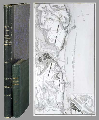
THIERS, Adolphe (1797-1877):
Histoire du Consulat et de l'Empire faisant suite à l'histoire de la Révolution française. 20 tomes + Atlas de l'histoire du Consulat et de l'Empire, dressé et dessiné sous la direction de M. Thiers par MM. Dufour et Duvotenay, gravé sur acier par Dyonnet. Ensemble 21 volumes.
Paris, Paulin-Lheureux, 1845-62, atlas (1866), in-8vo, atlas in-folio, chaque volume env. 500 p., l'atlas comprend 66 cartes dont 7 sur double-page montées sur onglets (deux coloriées), non paginé, toutes les cartes en excellent état + 2 cartes ajoutées: une carte du Nord de l'Italie pour l'étude de la campagne de Napoléon III en1859 par le colonel Suisse F. Lecomte et une carte en fac-similé de la ville de Paris en 1576, reliures en pleine percaline verte, dos et plats estampés de filets à froid, quelques frottements et usures. Atlas in-folio relié en demi-chagrin, dos à nerfs orné de filets dorés, Généralement bel ensemble.
Bookseller reference : 71051aaf
|
|
|
THIERRY (Augustin)
Histoire de la conquête de l'Angleterre par les Normands, de ses causes et de ses suites jusqu'à nos jours en Angleterre, en Ecosse, en Irlande et sur le continent + Histoire de la conquête de l'Angleterre par les Normands, de ses causes et de ses suites jusqu'à nos jours en Angleterre, en Ecosse, en Irlande et sur le continent - Atlas.
Paris, Garnier frères / Just Tessier, 1867 / 1839 5 volumes In-12 (11 x 17,8cm) / Format oblong (27 x 20,4cm) Reliure demi-basane verte d'époque; dos à 4 nerfs ornés et soulignés de filets à froid, 3 fleurons dorés, auteur et titre et tomaisons dorés / Atlas en reliure demi-basane bleu nuit; dos lisse orné en long de motifs dorés. Vol.1: 1faux-titre, 1titre, 443p.; Vol.2: 1faux-titre, 1titre, 400p.; Vol.3: 1faux-titre, 1titre, 400p.; Vol.4: 1faux-titre, 1titre, 372p. Quelques petits défauts de reliure (coiffes frottées, petites éraflures sur les dos) et quelques rousseurs éparses; cachets d'ex-libris. + Atlas: 1faux-titre, 1titre, 32p., 14 planches dont 4 cartes et 1 fac-similé dépliant. Coiffes frottées; petit accroc au dos; pâle mouillure en marges; rousseurs; petite déchirure sans manque au fac-similé.
Bookseller reference : 12993
|
|
|
Thiel, Reinhold
Argo-Reederei und Atlas-Levante-Linie. 100 Jahre bremische Seeschiffahrt
Bremen: Verlag H. M. Hauschild, 1994. 239 S. ; 27,5 x 22,5 cm ; Pp. ;
Bookseller reference : 129063

|
|
|
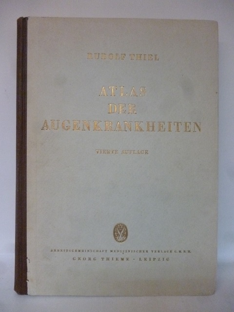
Thiel, Rudolf
Atlas der Augenkrankheiten. Sammlung typischer Krankheitsbilder mit kurzen diagnostischen und therapeutischen Hinweisen. 4., unveränderte Auflage.
Leipzig: Verlag Georg Thieme, 1947. 244 S., mit 634, meist farbigen Abbildungen. 4°, Halbleinen m. Rücken- u. Deckeltitel
Bookseller reference : 127645
|
|
|
Thiele, R. A
JRO - Taschenatlas. Das kleine Nachlagwerk in der Tasche.
München, JRO-Verlag, ca. 1941. 8° klein, 71 S. altersbed. Bräunung, Einbd.beschabt u. min. eingerissen, Gebr.sp., kartoniert
Bookseller reference : 7061
|
|
|
Thieme, Karlheinz
Länderlexikon, Weltatlas - Die Länder der Erde von A-Z
Gütersloh, BERTELSMANN LEXIKOTHEK VERLAG GmbH, 1986. 431 Seiten , 18 cm, Hardcover/Pappeinband
Bookseller reference : 47558
|
|
|
THIERRY (Augustin)
Histoire de la conquête de l'Angleterre par les Normands, de ses causes et de ses suites jusqu'à nos jours en Angleterre, en Ecosse, en Irlande et sur le continent + Histoire de la conquête de l'Angleterre par les Normands, de ses causes et de ses suites jusqu'à nos jours en Angleterre, en Ecosse, en Irlande et sur le continent - Atlas.
Réédition, complète en 4 volumes, d'un ouvrage publié en 1825 par Augustin THIERRY (1795-1856), augmenté en 1826, puis modifié lors de sa 3è édition en 1830; avec l'avertissement pour la 3è édition; pièces justificatives et documents, sources et bibliographie. 3è, 4è, 5è et 6è volumes de l'édition collective posthume des oeuvres de l'historien (mais tomaison aux dos de 1 à 4), avec mention de "nouvelle édition revue avec le plus grand soin". Exemplaire enrichi de l'atlas qui accompagnait la 5è édition (1839), bien complet de ses 14 planches: 4 cartes, 5 planches reproduisant la tapisserie de Bayeux (avec description de M. LANCELOT), 1 fac-similé dépliant d'extraits et signature d'une charte de Guillaume-le-Conquérant (suivie du texte), 1 planche de sceaux des rois d'Angleterre, 1 de monnaies anglo-saxonnes et anglo-normandes, 1 d'armes et pièces d'armures anglo-saxonnes, anglo-danoises et anglo-normandes, 1 d'architectures saxonne et normande: cartes et planches gravées par Ambroise TARDIEU, sauf architecture et armes gravées par MAILLARD d'après A. H. CABASSON. Français

|
|
|
THIERS (Adolphe) - DUFOUR (A.) - DUVOTENAY
Atlas de l'Histoire du Consulat et de l'Empire. Dressé et dessiné sous la direction de M.Thiers par MM. A. Dufour et Duvotenay, gravé en relief par M.Gillot, inventeur de la paniconographie.
In-4 à l'italienne. Rassemble 66 cartes montées sur onglet. Quelques rousseurs, plutot marginales. Autrement très bel exemplaire.
|
|
|
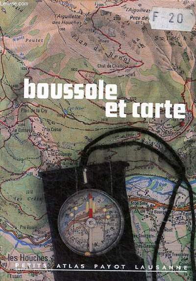
THONE KARL ET KAUFMANN EDWIN
BOUSSOLE ET CARTE
PAYOT LAUSANNE. NON DATE. In-12. Broché. Bon état, Couv. convenable, Dos satisfaisant, Intérieur frais. 74 pages - Nombreuses illustrations en noir et blanc et couleurs dans et hors texte. . . . Classification Dewey : 912-Atlas, cartes et plans
Bookseller reference : R320079320
|
|
|
Thomas (de Tours) Docteur
Eléments d'otéologie descriptive et comparée de l'homme et des animaux domestiques. Atlas de 12 planches
1865 Paris Delahaye 1865
Bookseller reference : 7829
|
|
|
THOREZ Paul
MOSCOU.
reliure éditeur - 17,5x27 - 215 pp - 1964 - éditions RENCONTRE, Lausanne.Collection " ATLAS DES VOYAGES, RENCONTRE" dirigée par Charles-Henri FAVROD.Nombreuses illustrations dans et hors texte.
Bookseller reference : 4950
|
|
|
Thom, Ernst
Pharus Städte- Atlas enthaltend die Pharus-Pläne Berlin/Potsdam/Bremen/Breslau/Cassel/Cöln am Rhein/Dresden/Düsseldorf, Frankfurt am Main/Hamburg/Hannover/Kiel/Königsberg/Leipzig/Magdeburg/München/Nürnberg/Stettin/Stuttgart/Wiesbaden. Verkehrsausgabe 1905/06
Berlin, Pharus-Varlag, 1905/06. 2°, 20 doppelblattgroße Karten, 194 S., LVI S; goldgepr. OHLn
Bookseller reference : 7-10-678

|
|
|
Thom, Ernst
Pharus-Atlas Deutscher Städte. Mit illustrierten Bäder-Anzeigen, Führer, Hotel-Register etc. und einem Anhang der Stadtpläne von Brüssel, London, Paris und Wien, Sonderanhang Schweiz und Mitglieder-Verzeichnis des Interantionalen Möbel-Transport-Verbandes
Hamburg, Deutsche Verlags-Gesellschaft, Ausgabe 1912/17. 2°, 24 doppelblattgroße Karten, 261, LVI S; goldgepr. OHLn
Bookseller reference : 7-10-421

|
|
|
Thomas, Oswald
Atlas der Sternbilder mit figuralen Darstellungen von Richard Teschner.
Salzburg, Bergland-Buch, 1945. 154 S., 1 Bl. mit 90 ganzseit. Abb. OHLwd. (etw. bestoßen und gebräunt).
Bookseller reference : 17616
|
|
|
THOMAS, Oswald
Atlas der Sternbilder. Mit figuralen Darstellungen von Richard Teschner. + 1 Beigabe.
Salzburg, "Das Bergland-Buch" 1945. quer-4°, 154(1) S., mit 90 Taf., OHln., Kanten berieben. - Beiliegend: "Carte du ciel. Dressée par l'Institut Geographique National pour le 1er Janvier 1980. Ca 72 x 74 cm, rot u. schwarz gedruckt. Beigabe: Thomas, Oswald: Astronomie. Tatsachen und Probleme. Salzburg, Das Bergland-Buch 1942. OLn.
Bookseller reference : NATW0150a
|
|
|
Thompson Sanford E. Sanford Eleazer Atlas Portland Cement Company
Reinforced concrete in factory construction 1907 Leather Bound
2019. Leather Bound. New. Leather Binding on Spine and Corners with Golden Leaf Printing on round Spine. Reprinted in 2019 with the help of original edition published long back 1907. This book is printed in black & white sewing binding for longer life Printed on high quality Paper re-sized as per Current standards professionally processed without changing its contents. As these are old books we processed each page manually and make them readable but in some cases some pages which are blur or missing or black spots. If it is multi volume set then it is only single volume if you wish to order a specific or all the volumes you may contact us. We expect that you will understand our compulsion in these books. We found this book important for the readers who want to know more about our old treasure so we brought it back to the shelves. Hope you will like it and give your comments and suggestions. Lang: - eng Pages 262. EXTRA 10 DAYS APART FROM THE NORMAL SHIPPING PERIOD WILL BE REQUIRED FOR LEATHER BOUND BOOKS. FOLIO EDITION IS ALSO AVAILABLE. hardcover
Bookseller reference : LB1111005210657
|
|
|
Thompson Sanford E. Sanford Eleazer Atlas Portland Cement Company
Reinforced concrete in factory construction 1907 Hardcover
2020. Hardcover. New. Lang: - eng Pages 262. Reprinted in 2020 with the help of original edition published long back 1907. This book is Printed in black & white Hardcover sewing binding for longer life with Matt laminated multi-Colour Dust Cover Printed on high quality Paper re-sized as per Current standards professionally processed without changing its contents. As these are old books we processed each page manually and make them readable but in some cases some pages which are blur or missing or black spots. If it is multi volume set then it is only single volume if you wish to order a specific or all the volumes you may contact us. We expect that you will understand our compulsion in these books. We found this book important for the readers who want to know more about our old treasure so we brought it back to the shelves. Any type of Customisation is possible with extra charges. Hope you will like it and give your comments and suggestions. hardcover
Bookseller reference : 1111005210657
|
|
|
Thompson Sanford E. Sanford Eleazer Atlas Portland Cement Company
Reinforced concrete in factory construction 1907
2020. Paperback. New. Lang: - eng Pages 262. Reprinted in 2020 with the help of original edition published long back 1907. This book is Printed in black & white sewing binding for longer life with Matt laminated multi-Colour Soft Cover HARDCOVER EDITION IS ALSO AVAILABLE Printed on high quality Paper re-sized as per Current standards professionally processed without changing its contents. As these are old books we processed each page manually and make them readable but in some cases some pages which are blur or missing or black spots. If it is multi volume set then it is only single volume if you wish to order a specific or all the volumes you may contact us. We expect that you will understand our compulsion in these books. We found this book important for the readers who want to know more about our old treasure so we brought it back to the shelves. Any type of Customisation is possible with extra charges. Hope you will like it and give your comments and suggestions. paperback
Bookseller reference : PB1111005210657
|
|
|
THUILIER - HACQ
1 CARTE ENTOILEE DE PERIGEUX
DEPOT DE LA GUERRE. 1909. In-Folio. Broché. Bon état, Couv. convenable, Dos satisfaisant, Intérieur frais. 1 carte entoilée de 86 x 58,5 cm, dépliante, en noir et blanc. Echelle 1/80000.. . . . Classification Dewey : 912-Atlas, cartes et plans
Bookseller reference : RO30079598
|
|
|
THUILLIER / HACQ / GODART
Carte de Avallon
DEPOT DE GUERRE. Fin XIXème. In-Plano. En feuillets. Bon état, Couv. convenable, Dos satisfaisant, Intérieur frais. Carte dépliante de 88/62 cm, en noir et blanc. Pas de plats de couverture.. . . . Classification Dewey : 912-Atlas, cartes et plans
Bookseller reference : RO80009148
|
|
|
THUILLIER / HACQ / HENNEQUIN
Carte de Meaux N°49
DEPOT DE GUERRE. 1912. In-Plano. En feuillets. Bon état, Couv. convenable, Dos satisfaisant, Intérieur frais. Carte dépliante en noir et blanc, de 85/59cm. Pas de plats de couverture.. . . . Classification Dewey : 912-Atlas, cartes et plans
Bookseller reference : RO80006326
|
|
|
THUILLIER / COUSTEIX / LECOCQ
Carte du S.E De Luz.
INSTITUT GEOGRAPHIQUE NATIONAL. Non daté. In-Plano. En feuillets. Bon état, Couv. convenable, Dos satisfaisant, Intérieur frais. Carte dépliante en noir et blanc, hors-texte, de 70/55 cm. Pas de plats de couverture. Tampon.. . . A l'italienne. Classification Dewey : 912-Atlas, cartes et plans
Bookseller reference : RO80017183
|
|
|
THUILLIER / BLANCHARD / GERIN / BEAUPRE
Carte d'Agen. N°205
DEPOT DE LA GUERRE. 1884. In-Plano. Cartonnage d'éditeurs. Bon état, Livré sans Couverture, Dos satisfaisant, Intérieur acceptable. Carte dépliante entoilée, en noir et blanc, hors-texte, de 90 / 60 cm. Quelques parties brunies.. . . . Classification Dewey : 912-Atlas, cartes et plans
Bookseller reference : RO80053017
|
|
|
THUILLIER et HACQ
Carte de Wassy . N° 68
DEPOT DE LA GUERRE. 1913. In-Plano. En feuillets. Bon état, Livré sans Couverture, Dos satisfaisant, Intérieur acceptable. Carte dépliante en noir et blanc de 59 / 84 cm. . . A l'italienne. Classification Dewey : 912-Atlas, cartes et plans
Bookseller reference : RO80072069
|
|
|
THUILLIER, HACQ et KARDL
Carte de Douai. N°8
DEPOT DE LA GUERRE. 1914. In-Plano. En feuillets. Bon état, Livré sans Couverture, Dos satisfaisant, Intérieur acceptable. Carte dépliante en noir et blanc de 59 / 84 cm. . . A l'italienne. Classification Dewey : 912-Atlas, cartes et plans
Bookseller reference : RO80072072
|
|
|
THUILLIER, HACQ et HENNEQUIN
Carte de Maubeuge, Sud-Ouest et Sud-Est. N°9
DEPOT DE LA GUERRE. 1913. In-Folio. En feuillets. Bon état, Livré sans Couverture, Dos satisfaisant, Intérieur frais. Carte dépliante en noir et blanc de 30 / 84 cm.. . . A l'italienne. Classification Dewey : 912-Atlas, cartes et plans
Bookseller reference : RO80072063
|
|
|
THUILLIER / HACQ / ORGIAZZI
Carte de Wassy.
DEPOT DE GUERRE. 1913. In-Plano. En feuillets. Bon état, Couv. convenable, Dos satisfaisant, Intérieur bon état. Carte dépliante en noir et blanc de 84/59 cm. Pas de plats de couverture. Pliures.. . . . Classification Dewey : 912-Atlas, cartes et plans
Bookseller reference : RO20040370
|
|
|
THUILLIER / HACQ / ORQIAZZI / ROUILLARD
Carte de Bourg, Sud-Est.
SERVICE GEOGRAPHIQUE DE L'ARMEE. 1889. In-Plano. En feuillets. Bon état, Couv. convenable, Dos satisfaisant, Intérieur bon état. Carte dépliante en noir et blanc, de 52/72 cm. Pas de plat de couverture.. . . A l'italienne. Classification Dewey : 912-Atlas, cartes et plans
Bookseller reference : RO20054699
|
|
|
THUILLIER / HACQ / BLONDEAU
Carte de Meaux
DEPOT DE GUERRE. 1832. In-Plano. En feuillets. Etat d'usage, Couv. convenable, Dos satisfaisant, Intérieur bon état. Carte dépliante bicolore, de 60/90 cm. Pas de plat de couverture. Quelques déchirures.. . . A l'italienne. Classification Dewey : 912-Atlas, cartes et plans
Bookseller reference : RO20054740
|
|
|
THUILLIER / HACQ / LEROY / ROUILLARD
Carte de Lure
DEPOT DE GUERRE. 1913. In-Plano. En feuillets. Bon état, Couv. convenable, Dos satisfaisant, Intérieur bon état. Carte dépliante en noir et blanc, de 64/88 cm. Pas de plat de couverture.. . . A l'italienne. Classification Dewey : 912-Atlas, cartes et plans
Bookseller reference : RO20054742
|
|
|
THUILLIER / HACQ / HENNEQUIN
Carte de Maubeuge (Sud-Oeust / Sud-Est)
DEPOT DE GUERRE. 1913. In-Plano. En feuillets. Bon état, Couv. convenable, Dos satisfaisant, Intérieur frais. Carte dépliante en noir et blanc, de 32/90 cm. Pas de plat de couverture.. . . A l'italienne. Classification Dewey : 912-Atlas, cartes et plans
Bookseller reference : RO20054744
|
|
|
THUILLIER, HACQ et HENNEQUIN
Carte entoilée de Maubeuge, Feuille N°9
DEPOT DE LA GUERRE. 1832. In-12. En feuillets. Très bon état, Livré sans Couverture, Dos satisfaisant, Intérieur frais. Carte dépliante entoilée, en noir et blanc, de 58 x 87 cm. Echelle 1 / 80000. . . A l'italienne. Classification Dewey : 912-Atlas, cartes et plans
Bookseller reference : RO80119640
|
|
|
THUILLIER, HACQ et Orgiazzi
Carte entoilée de Vassy, Feuille n°68
DEPOT DE LA GUERRE. 1874. In-12. En feuillets. Bon état, Livré sans Couverture, Dos satisfaisant, Intérieur frais. Carte dépliante entoilée, en noir et blanc, de 59 x 86 cm. Echelle 1 / 80000. . . A l'italienne. Classification Dewey : 912-Atlas, cartes et plans
Bookseller reference : RO80119646
|
|
|
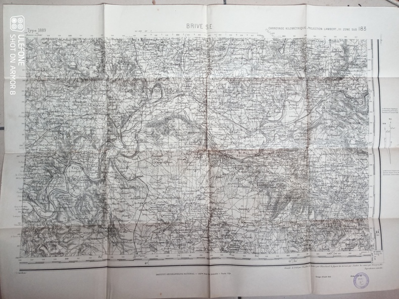
Thuillier, Blanchard, Soudan, Beaupré fils
Carte d'Etat-Major de Brive S.E. - Carroyage kilométrique, projection Lambert III, zone sud
Institut National Géographique. 1941. In-Plano. En feuillets. Bon état, Couv. convenable, Dos satisfaisant, Intérieur frais. Une carte en noir et blanc. Environ 54 x 74 cm. Tampon du Secrétariat d'Etat aux communications.. . . . Classification Dewey : 912-Atlas, cartes et plans
Bookseller reference : RO80240271
|
|
|
Thöne Karle teKaufmann Edwin
Boussole et carte N°73
Payot. non daté. In-18. Relié. Bon état, Couv. convenable, Dos satisfaisant, Intérieur frais. 74 pages augmentées de quelques photos en noir et blanc dans texte.. . . . Classification Dewey : 912-Atlas, cartes et plans
Bookseller reference : R260264584
|
|
|
TILMONT J., de ROECK M., LAMBION J., DEBULPAEP C.
Atlas.
Bruxelles, De Boeck-Wesmael, 1986. 25 x 35, 170 pp., très nombreuses cartes en couleurs, reliure d'édition carton imprimé, très bon état.
Bookseller reference : 89586
|
|
|
TILMONT, J. - DE ROECK, M.
Cours de Geographie, Tome I : Geographie Générale.
Maison d'Édition Ad. Wesmael Charlier ("Collection Roland"), 1952. in-8°, 341 pages + 107 illustrations, broché.
Bookseller reference : 80500
|
|
|
TILMONT, J. - DE ROECK, M.
Cours de Geographie, Tome I : Geographie Générale.
in-8°, 341 pages + 107 illustrations, broché. Excellent etat. [SO-1]
|
|
|
TIMMERS J.
Petit atlas de l'art roman.
Bruxelles, Séquoia, 1965 14 x 21, 241 pp., illustrations N/B et cartes, broché, bon état.
Bookseller reference : 7282
|
|
 Receive by email
 Download as PDF document
 RSS feed


