|
MONIN C.V., FREMIN M.
Suède, Norvège et Danemark - Îles Britanniques du Royaume de la Grande Bretagne.
AUBREE Armand. 1837. In-Plano. En feuillets. Etat d'usage, Livré sans Couverture, Dos satisfaisant, Mouillures. 2 cartes en double-planches, noir et blanc, hors-texte. Accrocs et déchirures sur marges en en-tête. (45 / 32 cm, chaque carte).. . . . Classification Dewey : 912-Atlas, cartes et plans
Bookseller reference : RO80039274
|
|
|
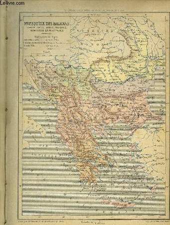
MONIN C.V., FREMIN M.
Turquie d'Europe et Grèce - Italie Suisse Tyrol et provinces autrichiennes
AUBREE Armand. 1837. In-Plano. En feuillets. Etat passable, Livré sans Couverture, Dos satisfaisant, Fortes mouillures. 2 cartes en double-planches, noir et blanc, hors-texte. Accroc sur marges en en-tête. (45 / 32 cm, chaque carte). . . A l'italienne. Classification Dewey : 912-Atlas, cartes et plans
Bookseller reference : RO80039272
|
|
|
MONIN, V. ; ALES
Petit Atlas National des Départemens de la France et de ses Colonies [ Petit Atlas National des Départements de la France et de ses Colonies ]
100 Cartes ornées, Vues des Monumens les plus remarquables, dressées par Monin et gravées sur acier par Alès, Nouvelle édition, revues corrigées et augmentées en 1835, 1 vol. in-4 oblong reliure de l'époque demi-basane marron, dos lisse orné en long, Chez Binet, Paris, s.d [ circa 1835 ]., 2 ff., 100 cartes et une grande carte dépliante : "France, Nouvelle Carte Physique, Routière et Administrative" format 59 x 64 cm Rare exemplaire bien complet de la grande carte complémentaire : "France, Nouvelle Carte Physique, Routière et Administrative". L'exemplaire contient bien 100 cartes (comme indiqué en titre) et une grande carte complémentaire (comme indiqué sur le billet contrecollé au feuillet de titre). Etat satisfaisant (couv. fort. frottée avec qq. manques, premiers ff. frottés) Français

|
|
|
MONLAU GEORGES, PROBST PIERRE
LE MONDE RACONTE A TOUS
Hachette. 1966. In-Folio Carré. Relié. Etat d'usage. Coins frottés. Dos frotté. Intérieur frais. 92 pages. Illustré de nombreux dessins en couleur. 'Encyclopédie en couleurs'. Préface de André Maurois. Europe. Asie. Afrique. Amérique. Océanie. Planisphère. Un continent neuf.

|
|
|
Monroe (Donald), Moulin (Jean), Noriey (Pierre)
Atlas du monde.
français Paris, Compagnie Française "Atlas", 1936. In-4 de 48 pp.; album cartonné illustré de l'éditeur, dos toilé rouge. Comprenant 28 cartes en couleurs, 48 photographies, 20 tableaux et un index de plus de 1800 noms des villes principales de France, de Belgique, de Suisse, et du monde entier. Bon état. Petites tâches et salissures.
|
|
|
MONTIER, David J.
Atlas of Breeding Birds of the London Area
cr 4to; 288pp, tables, maps (one for each species). original cloth, dj, fine. A picture of this book is available upon request by email.
|
|
|
Moon Atlas; Krieger Joh. Nep
JOH. NEP. KRIEGERS MOND-ATLAS Nacch seinen an der Pia-Sternwarte in Triest angestellten Beobachtungen unter Zugrundelegung der hinterlassenen Zeichnungen und Skizzen bearbeitet und mit Unterstützung der kaiserl Akademie der Wissen-schaften in Wien aus den Mitteln der Treitl-Stiftung herausgegeben von Rudolf König
Wien: In Kommission bei Eduard Heinrich Mayer Leipzig and William Wesley & Son London 1912. 2 volumes Text and Atlas. First of the Edition. With a fine photograph of Krieger as frontispiece 31 other illustrations to the first volume and 58 full page photographs of the lunar surface to the second the atlas volume printed on heavy stock each with an overlay depicting the names for the areas shown in the photographs and with a large multi-folding map of the moon at the end of the volume. Large 4to publisher's original gray cloth the covers and spines lettered in red. xviii 376; 29-86 plates with overlays collated complete and as called for. Numbers correspond to Krieger's system of numbering. A fine copy internally the maps overlays and photographs all in fine order the bindings show some evidence of age or use and some evidence of old damp at the edges the cloth is whole and complete and without breakage. Still a well preserved set. FIRST EDITION IN THE BEST FORMAT PHOTOGRAPHS WITH OVERLAYS AND THE FOLDING MAP. Johann Nepomuk Krieger lived from 4 February 1865 - 10 February 1902. The crater Krieger on the Moon is named in his honor.<br> Krieger was born in the Kingdom of Bavaria and at an early age gained an interest in astronomy. Having been inspired by the director of the Cologne Observatory Hermann Klein to make the study and observation of the Moon his life's work. he used the money from an inheritance to build an observatory in the suburbs of Munich.<br> Krieger's decision to create a definitive map of the Moon moved him to obtain a series of low-resolution negatives of the lunar surface that had been taken at the Lick and Paris observatories. He enlarged these images and used them to provide positional accuracy for his subsequent drawings. His illustrations of the Moon were made in charcoal graphite pencil and ink and were considered superior to any previously produced lunar maps in their accuracy and level of detail and continue to be considered works of art.<br> He lived long enough to see his first 28 plates published as volume 1 of his "Mond Atlas". However his health had suffered possibly due to his long nightly labors at his telescope. About 10 years following his death his remaining drawings and sketches were published in a second volume by the Austrian selenographer Rudolf König. In Kommission bei Eduard Heinrich Mayer, Leipzig and William Wesley & Son, London hardcover
Bookseller reference : 27388

|
|
|
Moore (Patrick)
L'atlas de l'Univers.
français In-folio de 272 pp.; album orn à la Bradel de l'éditeur, sous jaquette illustrée. Préface par Sir Bernard Lovell, posface par Thomas Paine. Riche iconographie et illustration en noir et couleur. Petites usures aux bords de la jaquette.
|
|
|
Moore, Patrick
Hallwag Weltraumatlas.
Bern, Stuttgart., Hallwag Verlag., 1970. Vorwort von Bernard Lovell, Nachwort von Thomas Paine. 272 Seiten mit zahlreichen Weltraumbildern und Zeichnungen. Zustand: Aus einer Institutsbibliothek ausgeschieden, Titelblattrückseite und Inhaltsverzeichnis mit Bibliotheksstempel. 4°. OLeinen.
Bookseller reference : 044700
|
|
|
Moore, Patrick / Hunt, Garry / Nicolson, Iain / Cattermole, Peter
Atlas des Sonnensystems, in Zusammenarbeit mit der Royal Astronomical Society, Vorwort von Graham Smith,
Freiburg im Breisgau, Herder, 1985. 4°, 462 S. mit zahlreichen teils ganzseitigen Farb- und s/w-Abbildungen, blauer original Pappband (Hardcover), farbig illustr. original Schutzumschlag, blaue Vorsätze, erste Auflage dieser Ausgabe schönes, frisches, sauberes Exemplar mit ebensolchem Schutzumschlag.
Bookseller reference : 13405BB

|
|
|
MORIEU et PERRIN
Atlas de la Nouvelle Géographie Moderne, dressé d'après les documents les plus récents. Cinq parties du Monde.
GIRARD E. et A. BOITTE. XIXe siècle.. In-4. Relié demi-cuir. Etat d'usage, Couv. défraîchie, Dos à nerfs, Intérieur acceptable. 44 planches + 6 doubles planches de cartes illustrées en couleurs. Titre, filets et caissons dorés sur demi-veau noir. Dos à 5 nerfs. Légères épidermures sur le dos. Plats mouillurés.. . . . Classification Dewey : 912-Atlas, cartes et plans
Bookseller reference : RO80070976
|
|
|
MORRIS Neil
Atlas des Civilisations Anciennes.
DES PETITS CHAMPS. 2001. In-4. Cartonné. Bon état, Couv. convenable, Dos satisfaisant, Intérieur frais. 30 pages. Nombreuses illustrations en couleurs, dans le texte et hors-texte.. . . . Classification Dewey : 912-Atlas, cartes et plans
Bookseller reference : RO80147710
|
|
|
Morneau Claude
Chicago
Ulysse. 1997. In-12. Broché. Bon état, Couv. convenable, Dos satisfaisant, Intérieur frais. 426 pages. Quelques photos en couleur hors texte. Nombreuses illustratrions et carte en noir et blanc dans le texte.. . . . Classification Dewey : 912-Atlas, cartes et plans
Bookseller reference : RO80238147
|
|
|
MORINEAU Raymond
EGYPTE.
reliure éditeur - 17,5x27 - 215 pp - 1964 - éditions RENCONTRE, Lausanne.Collection " ATLAS DES VOYAGES, RENCONTRE" dirigée par Charles-Henri FAVROD.Nombreuses illustrations dans et hors texte.
Bookseller reference : 4949
|
|
|
MORTIER ( Pieter), DESRAY (Éditeur)
Nouvel Atlas de la Bible, pour servir a l'intelligence des livres sacrés de l'Ancien et du Nouveau Testament.
Paris, Chez Desray, 1809, in-folio, faux-titre, titre et 6 cartes à double page et montées sur onglets, relié demi toile, ex-libris en page de garde, frottements.
Bookseller reference : PHO-1531
|
|
|
MORISOT, Claude Barthélémy
Orbis maritimi sive rerum in mari et littoribus gestarum generalis historia... Première et unique édition de la première encyclopédie dédiée au monde maritime.
Très bon exemplaire, généreux de marges, conservé dans sa reliure en vélin de l'époque. Dijon, P. Palliot, 1643.In-folio de (13) ff. dont 1 titre frontispice, 725 pp., (19) pp., dont 1 planche à pleine page, 43 gravures dans le texte, 1 planche dépliante hors-texte. Déchirure marginale pp. 105 et 465 sans manque, coin inf. de la p. 505 déchiré avec manque mais sans atteinte au texte, pte. galerie de vers marginale pp. 247 à 270, qq. piqûres marginales, marge latérale des 3 premiers ff. légèrement rognée, pte. brulure ds. le frontispice. Vélin rigide, double encadrement de filets à froid sur les plats, fleurons frappés à froid aux angles, médaillon frappé à froid au centre avec la devise Animis Illabere Nostris, dos à nerfs orné de fleurons à froid, tranches mouchetées rouges. Reliure de l’époque.358 x 220 mm.
Bookseller reference : LCS-17556
|
|
|
Morgenroth, Konrad und Georg Rühl
Taschenatlas Pathohistologie der Mundhöhle.
Stuttgart ; New York : Thieme, 1990. 166 S.; 19 cm Taschenbuch
Bookseller reference : 10986
|
|
|
Morris, Philip
JRO Welt Atlas
München, JRO Kartografische Verlagsgesellschaft, 1990. 246 Seiten , 19 cm, Hardcover/Pappeinband
Bookseller reference : 45679

|
|
|
Morrow Prince A. Prince Albert author Kaposi Moriz Also issued as: Morrow Prince A. Prince Albert . Atlas of skin an
Atlas of skin and venereal diseases : comprising original illustrations and selections 1888 Leather Bound
2019. Leather Bound. New. Leather Binding on Spine and Corners with Golden Leaf Printing on round Spine extra customization on request like complete leather Golden Screen printing in Front Color Leather Colored book etc. Reprinted in 2019 with the help of original edition published long back 1888. This book is printed in black & white sewing binding for longer life Printed on high quality Paper re-sized as per Current standards professionally processed without changing its contents. As these are old books we processed each page manually and make them readable but in some cases some pages which are blur or missing or black spots. If it is multi volume set then it is only single volume if you wish to order a specific or all the volumes you may contact us. We expect that you will understand our compulsion in these books. We found this book important for the readers who want to know more about our old treasure so we brought it back to the shelves. Hope you will like it and give your comments and suggestions. Lang: - eng. EXTRA 10 DAYS APART FROM THE NORMAL SHIPPING PERIOD WILL BE REQUIRED FOR LEATHER BOUND BOOKS. COMPLETE LEATHER WILL COST YOU EXTRA US$ 25 APART FROM THE LEATHER BOUND BOOKS. hardcover
Bookseller reference : LB1111006339143
|
|
|
Morrow Prince A. Prince Albert author Kaposi Moriz Also issued as: Morrow Prince A. Prince Albert . Atlas of skin an
Atlas of skin and venereal diseases : comprising original illustrations and selections 1888 FULL LEATHER BOUND
2019. SUPER DELUXE EDITION. New. Antique look with Golden Leaf Printing and embossing with round Spine completely handmade bindingextra customization on request like Color Leather Colored book special gold leaf printing etc. Reprinted in 2019 with the help of original edition published long back 1888. This book is printed in black & white sewing binding for longer life Printed on high quality Paper re-sized as per Current standards professionally processed without changing its contents. As these are old books we processed each page manually and make them readable but in some cases some pages which are blur or missing or black spots. If it is multi volume set then it is only single volume if you wish to order a specific or all the volumes you may contact us. We expect that you will understand our compulsion in these books. We found this book important for the readers who want to know more about our old treasure in old look so we brought it back to the shelves. Hope you will like it and give your comments and suggestions. Lang: - eng. EXTRA 10 DAYS APART FROM THE NORMAL SHIPPING PERIOD WILL BE REQUIRED. Normal Hardbound Edition is also available on request. unknown
Bookseller reference : SD1111006339143
|
|
|
Morrow Prince A. Prince Albert author Kaposi Moriz Also issued as: Morrow Prince A. Prince Albert . Atlas of skin an
Atlas of skin and venereal diseases : comprising original illustrations and selections 1888
2019. Paperback. New. Lang: - eng. Reprinted in 2019 with the help of original edition published long back 1888. This book is Printed in black & white sewing binding for longer life with Matt laminated multi-Colour Soft Cover HARDCOVER EDITION IS ALSO AVAILABLE Printed on high quality Paper re-sized as per Current standards professionally processed without changing its contents. As these are old books we processed each page manually and make them readable but in some cases some pages which are blur or missing or black spots. If it is multi volume set then it is only single volume if you wish to order a specific or all the volumes you may contact us. We expect that you will understand our compulsion in these books. We found this book important for the readers who want to know more about our old treasure so we brought it back to the shelves. Any type of Customisation is possible with extra charges. Hope you will like it and give your comments and suggestions. paperback
Bookseller reference : PB1111006339143
|
|
|
Morrow Prince A. Prince Albert author Kaposi Moriz Also issued as: Morrow Prince A. Prince Albert . Atlas of skin an
Atlas of skin and venereal diseases : comprising original illustrations and selections 1888 Hardcover
2019. Hardcover. New. Lang: - eng. Reprinted in 2019 with the help of original edition published long back 1888. This book is Printed in black & white Hardcover sewing binding for longer life with Matt laminated multi-Colour Dust Cover Printed on high quality Paper re-sized as per Current standards professionally processed without changing its contents. As these are old books we processed each page manually and make them readable but in some cases some pages which are blur or missing or black spots. If it is multi volume set then it is only single volume if you wish to order a specific or all the volumes you may contact us. We expect that you will understand our compulsion in these books. We found this book important for the readers who want to know more about our old treasure so we brought it back to the shelves. Any type of Customisation is possible with extra charges. Hope you will like it and give your comments and suggestions. hardcover
Bookseller reference : 1111006339143
|
|
|
Motta, Giuseppe (Herausgeber)
Knaurs Atlas der Welt : [mit farbigem enzyklopädischen Teil: Erde und Weltall]. [Kartographie Gesamtleitung Giuseppe Motta. Enzyklopäd. Teil Gesamtleitung James Hughes]
München : Droemer Knaur 1987. XVI, 416 S. : überwiegend Ill., graph. Darst. u. Kt. ; 38 cm Kunststoff 0
Bookseller reference : 70640

|
|
|
MOULLART-SANSON, Pierre
Introduction à la Géographie en plusieurs cartes avec leur explication, par les Srs Sanson, Géographes ordinaires du Roy.
Dédiée à Monseigneur Jean Paul Bignon, Abbé de St Quentin, 1 vol. in-4 reliure de l'époque plein vélin vert, dos à 5 nerfs, Chès le Sr. Robert, Geographe du Roy, rue St jacques a St Paul, Paris, s.d. [ privilège général daté du 8 mars 1704 ], 9 ff. et pp. 2, 4-5, 8-9, 22-23, 25-86, 88-93, 95-106, 112-139 [ sans manque dans le texte, les manques dans la pagination sont imputables à l'absence des 34 planches qui s'y inséraient - on note une erreur de pagination : les pp. 131, 133 et 134 paginées 331, 233 et 234 ]
Bookseller reference : 26574
|
|
|
MOUREAUX
TOPOGRAPHIE, RECUEIL DE MODELES ELEMENTAIRES ET GRADUES
H. Dupuis, Paris. Non daté. In-8. Broché. Etat d'usage, Plats abîmés, Dos abîmé, Intérieur acceptable. Plaquette d'env. 30 pages illustrée de nombreux plans en noir et blanc. Avec quelques feuillets tirés à part. Manques sur le dos et les bords des plats. Tampon sur le 1er plat. Quelques feuillets détachés.. . . . Classification Dewey : 912-Atlas, cartes et plans
Bookseller reference : RO40198743
|
|
|
MOULLART-SANSON, Pierre
Introduction à la Géographie en plusieurs cartes avec leur explication, par les Srs Sanson, Géographes ordinaires du Roy.
Dédiée à Monseigneur Jean Paul Bignon, Abbé de St Quentin, 1 vol. in-4 reliure de l'époque plein vélin vert, dos à 5 nerfs, Chès le Sr. Robert, Geographe du Roy, rue St jacques a St Paul, Paris, s.d. [ privilège général daté du 8 mars 1704 ], 9 ff. et pp. 2, 4-5, 8-9, 22-23, 25-86, 88-93, 95-106, 112-139 [ sans manque dans le texte, les manques dans la pagination sont imputables à l'absence des 34 planches qui s'y inséraient - on note une erreur de pagination : les pp. 131, 133 et 134 paginées 331, 233 et 234 ] Cette rare introduction, qui ne contient pas de cartes, renvoie dans son texte à diverses cartes (foliotées jusqu'au numéro 34). Si l'on peut trouver des exemplaires d'autres éditions (à l'adresse : "dans le Cloitre de St Nicolas du Louvre"), on ne trouve aucune trace d'un autre exemplaire de la présente édition. Etat très satisfaisant (sans les planches, manque en coiffe sup., cahiers lég. brunis et un peu frottés, plats lég. obtondus). Français

|
|
|
MOUREAUX
TOPOGRAPHIE, RECUEIL DE MODELES ELEMENTAIRES ET GRADUES
H. Dupuis, Paris. Non daté. In-8 Carré. Broché. Etat d'usage. Plats abîmés. Dos abîmé. Intérieur acceptable. Plaquette d'env. 30 pages illustrée de nombreux plans en noir et blanc. Avec quelques feuillets tirés à part. Manques sur le dos et les bords des plats. Tampon sur le 1er plat. Quelques feuillets détachés. Terres arables. Vignobles. Prairies. Friches. Forêts et bois. Fleuves. Dunes. Routes. Ponts. Eglises...

|
|
|
MR DE ***
La GEOGRAPHIE ou description générale du ROYAUME de FRANCE.
REY Marc-Michel à Amsterdam. 1762. In-8. Relié plein cuir. Bon état, Couv. convenable, Dos satisfaisant, Intérieur frais. 160 pages et environ 30 cartes sur les environs de Paris à l'époque.Tome premier contenant les généralités sur Paris,toutes les provinces,villes,bourgs et villages de ce Royaume,la distance de Paris aux villes principales,et celles des villages aux villes dont ils dépendent;titre et caissons dorés.. . . . Classification Dewey : 912-Atlas, cartes et plans
Bookseller reference : ROD0000141
|
|
|
MUKERJEE, Ruchira;
UIT DE SCHADUW,
Amsterdam, Atlas, 1999 originele uitgeversomslag onder kartonomslag in kleur, 135 x 210mm., 223pp. ISBN 9045002019.
Bookseller reference : 32853
|
|
|
MULLIÉ Charles.-
Fastes de la France ou Tableaux Chronologiques, Synchroniques et Géographiques de l'Histoire de France depuis l'établissement des Francs jusqu'à nos jours.-
Indiquant les Evénemens politiques, les progrès de la civilisation et les hommes célèbres de chaque règne. 4e édition entièrement refondue. Lille. Lith. Bohem. 1841. In-f°(295 x 433mm) dos cuir fauve à 5 nerfs, plats et gardes marbrés, 2ff., 204 pages, 8 cartes hors texte sur double page. Texte sous forme de tableaux dans un encadrement typographique. Classement par périodes: Les Gaulois et les Franks, Siècle de Clovis (Mérovingiens), Siècle de Bélisaire, Siècle de Mahomet, etc. Chaque partie a sa propre page de titre le plus souvent ornée d'une vignette gravée sur bois. Belle page de titre général lithographiée, avec une grande variété de caractère typographique. Cachets discrets de bibliothèque, rousseurs et auréoles claires d'humidité, dos un peu râpé et insolé mais assez bon exemplaire de cet impressionnant ouvrage.
Bookseller reference : ORD-11886
|
|
|
MULLIé (Charles)
Fastes de la France, ou tableaux chronologiques, synchroniques et géographiques de l'histoire de France, depuis l'établissement des Francs dans les Gaules jusqu'à nos jours. Cinquième édition entièrement refondue
Paris, Poignavant 1845 In-folio. Reliure de l’époque, demi-chagrin grenat, dos lisse orné d’entrelacs dorés, 212 pp., 8 cartes coloriées hors texte sur double page. Reliure frottée, épidermures sur les plats, intérieur frais.
Bookseller reference : 88330
|
|
|
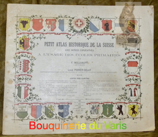
Mullhaupt, F. - Poirier-Delay, Louis.
Petit atlas historique de la Suisse. Avec des notices explicatives à l’usage des écoles primaires.
Berne, Henri Boneff 1899, 240x280mm, 7pages, broché.
Bookseller reference : 61300
|
|
|
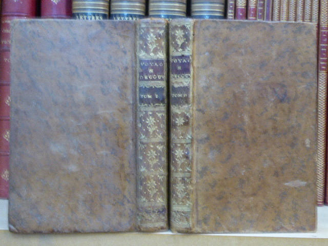
MULLER G.P.
Voyages et Découvertes Faites par les Russes le long des côtes de la Mer Glaciale & sur l'Océan Oriental, tant vers le Japon que vers l'Amérique. On y a joint L'Histoire du Fleuve Amur Et des pays adjacens, depuis le conquête des Russes avec la Nouvelle
Marc Michel Rey Amsterdam 1766 Voyages et Découvertes Faites par les Russes le long des côtes de la Mer Glaciale & sur l'Océan Oriental, tant vers le Japon que vers l'Amérique. On y a joint L'Histoire du Fleuve Amur Et des pays adjacens, depuis le conquête des Russes avec la Nouvelle Carte qui présente ces Découvertes & le cours de l'Amur, dressée sur des mémoires authentiques, publiée ar l'Académie des Sciences de St. Pétersbourg, & corrigée en dernier lieu. Ouvrages traduits de l'Allemand de Mr. G. P. MULLER, par C. G. F. DUMAS.2 volumes in-12 ( 170 X 100 mm ) de X-( 1 f.n.c. )-388 pages et IV-207 pages-( 12 ff.n.c. de table et catalogue ), plein veau havane, dos lisses ornés de caissons et fleurons dorés, pièces de titre et de tomaison en maroquin grenat, tranches jaspées ( Reliures de lépoque ). EDITION ORIGINALE française bien complète de sa grande carte dépliante in-fine des découvertes qui détaille, entre autres, le bassin de l'Ob et confirme l'existence jusqu'alors contestée du passage maritime entre l'Asie et l'Amérique et qui porte aujourd'hui le nom de "Détroit de Bering". BEL EXEMPLAIRE de cet ouvrage fondamental, "indispensable à lhistoire de la Découverte et de lexploration dans le Pacifique Nord" ( Sabin ).
Bookseller reference : 600465
|
|
|
Multiple Contributors
Bottles and Extras Magazine, No. 29, September 1992
64 pages. Great black and white photos and illustrations. Nice vintage ads on covers. Features: One Hail of a Story, by John Moore; Westmoreland's Mustards - The Westmoreland Specialty Company of Grapeville, PA; Jack La Baume tours the oldest Dr. Pepper Bottling Company in the world in Dublin, TX - great article and photos; Two Hard-to-Find Warners - Richard A. Cannon collects bottles from Hulbert Harrington Warner of Rochester, New York; Jar Talk - Jack La Baume has moved to Texas and shares his experiences; Extra Special Deliveries; Bottle Network News; British Bottle Bits - Nailsea Glass; Auction Directory; The Label Space - O.C. stands for the Oneida Community - a Smalley, Kivlan & Onthank's Double Safety Jar - An Atlas E-Z Seal packed by Harbauer; ; Up-Dates; Bottle Colors - article by Ben and Miriam Glassman. Unmarked with moderate wear. A sound copy. Book

|
|
|
Multiple Contributors
Equinox - The Magazine of Canadian Discovery: September/October 1987
Features: Everlasting Oasis - Canadian Archaeologists unearth 200,000 years of human habitation in Egypt's great Western Desert; Beluga Hunters - 'from time immemorial, this has been our life'; Traditions in Wood - hand-carved wildfowl decoys lure a new generation of collectors; Muddy Waters - Lake Winnipeg's rich fisheries and folkways face a stormy future; History's Lessons - a new atlas provides a fascinating vision of Canada and its development; The Daedalus Factor - Space-age materials replace the mythical wax and feathers in today's human-powered vehicles. Average wear. Sound copy. Book

|
|
|
Multiple Contributors
The Sphere - The Empire's Illustrated Weekly: 27 February, 1937
Photos: The Nizan's jubilee (the ruler of Hyderabad); Hitler on parade in Berlin on the 'Day of Heroes'; Spain's trekking population, and other aspects of the long continued civil war; With the 'Rodney' on the spring cruise; Clear photo of a half-man, half-ape creature discovered in the Atlas mountains on the northern edge of the Sahara by Marcel Homet, a French explorer; Archduke Otto - the Austrian claimant in his Belgian home; Egypt again sends the Mahmal and the Kiswa to Mecca; Britain's 5-year 1.5 billion pound re-armament plan; and more. Average wear. Unmarked. Sound copy. Book

|
|
|
Multiple Contributors
Time Magazine (Canadian Edition) May 11, 1962 - U.S. General Paul Harkins Cover Photo
72 pages. Features: Antisubmarine warfare, the 'St. Croix' and Vice Admiral Rayner; Big crowds for JFK in Berkeley and New Orleans; Test pilot Joe Walker and the X-15; Major Vietnam war coverage; Queen Juliana of the Netherlands; The European Common Market - toward ten; President Ayub of Pakistan; Manhattan's pioneering Institute of Physical Medicine and Rehabilitation; Photos of baseball players Cletis Leroy Boyer and Kenton Lloyd Boyer; Photo and coverage of Jack Nicklaus; Rocket Richard appears in Vitalis ad; Photo of Andy Warhol in art article; Passing of Frank Wilson Braden, Harry Guy Bartholomew, Walter Phelps Hall, Major General Ralph Emerson Truman and Helen Dortch Longstreet; Cosmonaut Gherman Stepanovich Titov tours U.S.; The P-1127 VTOL; Photo of California hod carriers on strike; Photo of Mr. Norman Brunt of Port Credit, Ontario in Atlas Steels ad; and more. Centerfold ad holding by one staple. Average wear. A sound vintage copy. Book

|
|
|
MUNSTER, Sebastian
Cosmographey oder beschreibung aller Länder herrschafften, fürnemsten Stetten, geschichten, gebreüche, hantierungen etc. Beschriben durch Sebastianum Munsterum, auch durch in selbst gebessert, an welt und natürliche historie, jetzunder aber bisz auff das 1569 jar… Très rare édition non décrite par Sabin de l’un des plus célèbres ouvrages de voyages, découvertes et géographie de la Renaissance.
« La Cosmographia Universalis de Münster fut l'un des ouvrages les plus lus du XVIe siècle et on peut vraisemblablement lui attribuer la seconde place en termes de popularité après la Bible. Au total plus de 120 collaborateurs ont participé à cette œuvre. L'ouvrage était à l'époque une référence en géographie et en histoire. » Ce livre fameux présente ainsi « la première carte de la Suisse ». Basel, in der Officin Henricpetrina, Im Jar 1569. In-folio de (100) ff. préliminaires y compris 1 frontispice gravé, suivis de 1467 pages de texte et gravures, la dernière non chiffrée pour la marque de l’imprimeur. Plein veau brun, encadrement d’un double filet doré sur les plats ornés d’une réserve centrale dorée arabisante surmontée sur le plat supérieur des chiffres H. C. H. avec la date de 1570 frappée or dessous, dos à quatre nerfs orné de fleurons à froid, coiffes et coins restaurés, tranches jaspées. Intéressante et élégante reliure de l’époque. 310 x 205 mm.
Bookseller reference : LCS-17771
|
|
|
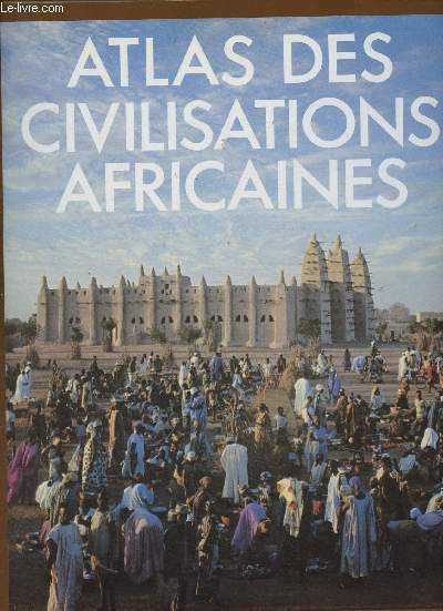
Murray Jocelyn
Atlas des civilisations africaines
Fanal. 1987. In-4. Relié toilé. Bon état, Couv. convenable, Dos satisfaisant, Papier jauni. 239 pages. Nombreuses illustrations en couleur et en noir et blanc, dans et hors texte. Jaquette en bon état.. Avec Jaquette. . . Classification Dewey : 912-Atlas, cartes et plans
Bookseller reference : RO30345531
|
|
|
Murray Jocelyn ( sous la direction de) ; Préface de Léopold Sédar Senghor
Atlas des Civilisations Africaines
Nathan, coll. « Beaux Livres » 1983 In-4 relié 30,5 cm sur 24. 239 pages. Jaquette en bon état. Bon état d’occasion.
Bookseller reference : 103600
|
|
|
MURET C.
LA LECTURE DES PLANS & CARTES TOPOGRAPHIQUES, ENSEIGNEE A L'AIDE D'UN TEXTE, D'UNE CARTE ET D'UN RELIEF
Institut Géographique de Paris Ch. 1873. In-12. Broché. Etat d'usage, Couv. légèrement passée, Dos frotté, Intérieur acceptable. 104 pages. Illustré de schémas, tableaux et cartes en noir et blanc dans le texte et sur quelques planches dépliables hors texte.. . . . Classification Dewey : 912-Atlas, cartes et plans
Bookseller reference : RO40233434
|
|
|
MURET C.
LA LECTURE DES PLANS & CARTES TOPOGRAPHIQUES, ENSEIGNEE A L'AIDE D'UN TEXTE, D'UNE CARTE ET D'UN RELIEF
Institut Géographique de Paris Ch. 1873. In-12 Carré. Broché. Etat d'usage. Couv. légèrement passée. Dos frotté. Intérieur acceptable. 104 pages. Illustré de schémas, tableaux et cartes en noir et blanc dans le texte et sur quelques planches dépliables hors texte. Collection d'ouvrages publiés sous la dir. de E. Levasseur.

|
|
|
Muris, Oswald
Hansa Handatlas 103 mehrfarbige Haupt- und Nebenkarten, ausführliches alphabetisches Namen- und Ortsregister,
Baden-Baden, Hermann Pfahle-Verlag, 1958. 128, 96 Seiten , 24 cm, Hardcover/Pappeinband
Bookseller reference : 43883

|
|
|
Muris, Oswald & Kleinert, Hans
Hansa Weltatlas. 103 mehrfarbige Haupt- und Nebenkarten nebst Geschichtsatlas mit Erläuterungen. Ausführliches alphabetisches Namen- und Ortsregister. 30000 Stichwörter.
Laupheim, Hermann Pfahl-Verlag, 1952. 8°, 96, 192, 95 Seiten, kartographische Gestaltung und Neuzeichnung der Geschichtskarten von Alfred Zimmermann, braunes Leinen, goldgeprägte Rücken- und Deckeltitel. 6. neubearbeitete und erweiterte Auflage Einband leicht berieben, gut erhalten.
Bookseller reference : 9034AB
|
|
|
Muris, Oswald u. Hans Kleinert
Hansa Weltatlas. 103 Mehrfarbige Haupt- und Nebenkarten nebst Geschichtsatlas mit Erläuterungen
Baden-Baden, Pfahl-Verlag, 1960. 11., textlich völlig neu gefaßte und erweiterte Auflage, 192, 191, 96 Seiten, 24 cm, goldgepr. OHalbleder. - Guter Zustand. fest gebunden/ hardcover
Bookseller reference : ATL1299
|
|
|
Muris, Oswald und Hans Kleinert
Universal Weltatlas - 103 mehrfarbige Haupt- und Nebenkarten nebst Geschichtsatlas mit Erläuterungen. Ausführliches alphabetisches Namen und Ortsregister 30 000 Stichwörter
Stuttgarter Hausbücherei, 1952. 7. Auflage 192, 95 Seiten , 24 cm, Leinen
Bookseller reference : 48142

|
|
|
Muris, Oswald und Otto Wand
Hansa Weltatlas - EXTRAKARTEN SIND NICHT VORHANDEN!!! mit75 Haupt- und Nebenkarten, 88 Abbildungen, Textteil und alphabetisches Ortsregister
Leipzig, Hermann Pfahl Verlag, 1943. 4. neubearbeitete und erweiterte Auflage 168, 144 Seiten , 21 cm, Hardcover/Pappeinband
Bookseller reference : 48518
|
|
|
MURRAY'S CLASSICAL ATLAS FOR SCHOOLS.
Edited by G.B. Grundy.
London John Murray 1959. XXIII p. 14 double-page maps. Hardbound 35 cm hardcover
Bookseller reference : 155395
|
|
|
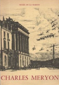
MUSEE DE LA MARINE
CHARLES MERYON : officier de Marine, peintre-graveur, 1821-1868 [Paris : Musée de la Marine, octobre 1968-janvier 1969]
Paris : Musée de la Marine, 1968. Broché 26x18cm, couverture illustrée, 889 documents présentés, photos en noir, essai de bibliographie, table alphabétique et analytique des noms de personnes, de navires et de lieux géographiques.
Bookseller reference : SPN-976
|
|
|
Muuß, Uwe
Luftbildatlas Nordrhein-Westfalen. eine Landeskunde in 80 farbigen Luftaufnahmen.
Neumünster, Wachholtz, 1969. 34 cm. 186 S. zahlr. Ill., Kt. OLwd. m. Or. Umschl. Umschl. m. Randläsur. u. Anriss. , Vors. leicht gebräunt ansonsten Buch in sehr gut. Zust.
Bookseller reference : 6327BB
|
|
 Receive by email
 Download as PDF document
 RSS feed


