|
Mitchell's Universal Atlas
Map of China
Measures 15.50" x 12.50" colored in pink green yellow. All very good condition. Thomas Cowperthwait & Co. Entered 1850 Clerk's Office District Court of the Eastern Dist. of Pennsylvania. unknown
Bookseller reference : 001944
|
|
|
Mitchell's Universal Atlas
Map of China
Thomas Cowperthwait & Co. Entered 1850 at the Clerk's Office District Court of the Eastern District of Pennsylvania. Map is colored in pink green and yellow. Borders are black with a green decorative border. Capitals Important towns are noted and the names of the five free ports are underscored. Map measures 15.25" x 12.50" placed on acid-free whiteboard and shrink-wrapped. All very good cond ition. unknown
Bookseller reference : 002080
|
|
|
Mitchell's Universal Atlas
Map of Connecticut
Size is 15.75" x 13". Colored insets of Hartford and New Haven. Colored in pink green and yellow. Also has a statistical table with population of counties from 1701 to 1850. Railroads canals court house capital etc. also noted. Thomas Cowperthwait & Co. Entered 1850 Clerk's Office District of Eastern Pennsylvania. All very good condition. unknown
Bookseller reference : 002042

|
|
|
Mitchell's Universal Atlas
Map of Denmark with Provinces
Thomas Cowperthwait & Co. Entered 1850 in the Clerk's Office in the District Office of the Eastern District of Pennsylvania. Map is colored in green pink and yellow. Border is black with green decorative border. Also lists canals. Map measures 11" x 13" placed on acid-free whiteboard and shrink-wrapped. All very good condition. unknown
Bookseller reference : 002081

|
|
|
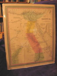
Mitchell's Universal Atlas
Map of Egypt &c
Inset of Nibia. Map measures 13.50" x 16" colored in pink green yellow black and white decorative light green borders all very good condition. Thomas Cowperthwait & Co. Entered 1850 Clerk's Off ice District Court Eastern Dist. of Pennsylvania. unknown
Bookseller reference : 001938
|
|
|
Mitchell's Universal Atlas
Map of England
Inset of Sicily "Environs of Liverpool" and "Environs of London". Measures 13.25" x 16.50" colored in pink green yellow and black and white decorative light green borders. Thomas Cowperthwait & Co. Entered 1850 Clerk's Office District Court of Eastern Dist. of Pennsylvania. Map is on acid-free white backboard and shrink wrapped. All very good condition. Cartography history geography Engl and London Liverpool. unknown
Bookseller reference : 000205

|
|
|
Mitchell's Universal Atlas Illustrated by Thomas Cowperthwait & Co
Map of Europe
With List of References on Germanic Confederation and Italy. Measures 16" x 13" colored in pink green yellow and black and white decorative light green borders all very good condition. Thomas Cow perthwait & Co. Entered 1850 Clerk's Office District Court of Eastern Dist. of Pennsylvania. Map is on acid-free whiteboard and shrink wrapped. Cartography history geography Europe. unknown
Bookseller reference : 000564

|
|
|
Mitchell's Universal Atlas
Map of France
Insets of Environs of Paris and Corsica. Lists Provinces. Entered 1850 by Thomas Cowperthwait & Co. Clerk's Office of District Court Eastern Dist. of Pennsylvania. Colored in pinks greens and yel lows. Decorative border in light green. Measures 13.25" x 16.75". Right side edge is rough with very small pieces missing on border only. All else is very good. Map is on acid-free whiteboard and shri nk-wrapped. Cartography maps France Europe Exploration History geography. unknown
Bookseller reference : 001201

|
|
|
Mitchell's Universal Atlas
Map of Greece
With Inset of Candia. Map measures 16.50" x 13.25" colored in pink green yellow and black and white. Thomas Cowperthwait & Co. entered 1850 Clerk's Office District Court of Eastern Dist. of Pen nsylvania. Map is on acid-free whiteboard and shrink wrapped. Decorative light green borders. All very good. Cartography geography history Greece Europe. unknown
Bookseller reference : 001410

|
|
|
Mitchell's Universal Atlas
Map of Hindoostan
Inset of The Delta of the Ganges. Lists British Territories Possessions States Under British Protection and Independent States. Map measures 13.50" x 16.50" colored in pink green yellow and blac k and white decorative light green borders. Thomas Cowperthwait & Co. Entered 1850 Clerk's Office District Court of the Eastern Dist. of Pennsylvania. All very good condition. unknown
Bookseller reference : 001943

|
|
|
Mitchell's Universal Atlas
Map of Holland and Belgium
Entered 1850 by Thomas Cowperthwait & Co. Clerks's Office of the District Court of Eastern District of Pennsylvania. Map measures 11.50" x 13.75" is colored in pink green and yellow. Decorative bo rders in light green. Map is on acid-free white backboard and shrink-wrapped. All in very good condition. Collectible maps Holland Belgium Europe history exploration. unknown
Bookseller reference : 000570

|
|
|
Mitchell's Universal Atlas
Map of Italy North Part
Entered 1850 by Thomas Cowperthwait & Co. in the Clerk's Office of the District Court of the Eastern District of Pennsylvania. Map measures 13.50" x 15.50". Map is on acid-free whiteboard and shrink-wrapped. Map is colored in pinks greens yellows and black and white. Decorative light green borders. All very good condition. Cartography maps Italy Europe exploration geography. Entered 1850 unknown
Bookseller reference : 001442

|
|
|
Mitchell's Universal Atlas Illustrated by Thomas Cowperthwait & Co
Map of Kingdom of Sardinia
With Inset of Island of Sardinia. Map measures 16.50" x 13.50" colored in pink green yellow and black and white; decorative light green borders. Thomas Cowperthwait & Co. Entered 1850 Clerk's Off ice District Court of Eastern Dist. of Pennsylvania. Map is shrink wrapped on acid-free whiteboard. All very good condition. Cartography geography history Sardinia. unknown
Bookseller reference : 000380

|
|
|
Mitchell's Universal Atlas
Map of Massachusetts and Rhode Island
Size is 16.50" x 13". Entered 1850 Thomas Cowperthwait & Co. Clerk's Office District for Eastern Pennsylvania. Colors on map are pink green and yellow. Insets of Boston with statistical tables for both st ates. Railroads canals etc. are shown. Also shows Cape Cod Bay Nantucket and Martha's Vineyard. All very good condition. unknown
Bookseller reference : 002046

|
|
|
Mitchell's Universal Atlas
Map of Mexico and Guatemala
Insets of Valley of Mexico and Guatemala. Map measures 16.50" x 13.25" colored in pink green yellow and black and white. Shows in black and white some of the Utah Territory and New Mexico. Shows C aptals States Mines and Battles. Entered 1850 by Thomas Cowperthwait & Co. Clerk's Office District Court Eastern Dist. of Pennsylvania. Decorative border in light green. All very good condition. Map is on acid-free whiteboard and shrink-wrapped. Cartography maps Mexico Guatemala geography history exploration. unknown
Bookseller reference : 001322
|
|
|
Mitchell's Universal Atlas
Map of New Hampshire and Vermont
Entered 1850 Thomas Cowperthwait & Co. Clerk's Office Eastern District of Pennsylvania. Map measures 13" x 16.25" and is colored in pink green and yellow. Population figures to 1850 canals railroads counties and county towns are noted. All very good condition. unknown
Bookseller reference : 002045

|
|
|
Mitchell's Universal Atlas
Map of New Jersey
Reduced from T. Gordon's Map. Entered 1850 by Thomas Cowperthwait & Co. Clerk's Office District Court Eastern Dist. of Pennsylvania. Measures 13" x 17.75". Colors are pink green yellow coral wi th light green decorative borders. Lists counties cities towns of New Jersey population canals railroads stage steamboat and canal routes from Trenton. Someone circled in ink the area around Philadelphia and Hamden. Overall good condition. unknown
Bookseller reference : 001948

|
|
|
Mitchell's Universal Atlas
Map of North America
Size is 17" x 13.75". Entered 1850 Thomas Cowperthwait & Co. Clerk's Office Eastern District of Pennsylvania. Map is colored in pink green yellow and coral. All very good condition. unknown
Bookseller reference : 002060

|
|
|
Mitchell's Universal Atlas
Map of Palestine and Adjacent Countries
Inset of Environs of Jerusalem in yellow. Turkish Provinces listed list of Decapolis Explanation Remarks of Dead Sea and River Jordan colored in pink yellow green and black and white all very g ood condition. Map measures 13.50" x 16.75". Thomas Cowperthwait & Co. Entered 1850 Clerk's Office District Court of Eastern Dist. of Pennsylvania. Map is on acid-free whiteboard and shrink wrapped. Cartography history geography Palestine Jerusalem Mid-East countries Dead Sea River Jordan. unknown
Bookseller reference : 001191

|
|
|
Mitchell's Universal Atlas
Map of Persia Arabia &c
Map measures 16.25" x 13" colored in pink green yellow and black and white decorative light green borders all very good condition. Thomas Cowperthwait & Co. Entered 1850 Clerk's Office Distric t Court of Eastern Dist. of Pennsylvania. unknown
Bookseller reference : 001937

|
|
|
Mitchell's Universal Atlas
Map of Prussia
With Capitals Towns Railroads. Inset on Environs of Berlin in blue. Measures 16" x 13" colored in pink green yellow and black and white decorative light green borders. Thomas Cowperthwait & Co. Clerk's Office District Court Eastern Dist. of Pennsylvania Entered 1850. Map is on acid-free whiteboard and shrink wrapped. All very good condition. Cartography geography history Prussia. unknown
Bookseller reference : 001730

|
|
|
Mitchell's Universal Atlas Illustrated by Thomas Cowperthwait & Co
Map of Russia In Europe
With lists of Governments Capital Towns Canals. Measures 11.75" x 13.25". Colored in pink green yellow and black and white. Thomas Cowperthwait & Co. Entered 1850 Clerk's Office District Court of Eastern Dist. of Pennsylvania. Map is on acid-free white backboard and shrink wrapped. Decorative borders in light green. All very good condition. Cartography geography history Europe Russia. unknown
Bookseller reference : 000600

|
|
|
Mitchell's Universal Atlas
Map of Russia in Asia and Tartary
Inset of Western Part of Russia. Measures 16" x 13.50" colored in pink green yellow and black and white. Decorative light green borders. Thomas Cowperthwait & Co. entered 1850 Clerk's Office Dis trict Court of Eastern Dist. of Pennsylvania. Map is on acid-free whiteboard and shrinkwrapped. All very good condition. Cartography geography history Russia Europe. unknown
Bookseller reference : 001598

|
|
|
Mitchell's Universal Atlas
Map of South America
Colors on map are pink yellow and green with decorative light green borders. Outer border has slight chips not affecting the borders of the map. Map measures 13.50" x 16.50". Entered 1850 by Thomas Cowperthwait & Co. Clerk's Office District Court of Eastern Dist. of Pennsylvania. Good condition. unknown
Bookseller reference : 001953
|
|
|
Mitchell's Universal Atlas Illustrated by Thomas Cowperthwait & Co
Map of Spain and Portugal
With inset of "Environs of Madrid". Colored with pink green yellow and black and white. Decorative light green border. Bottom edge rough small part of border is gone not affecting map. Measures 16 .75" x 13.50". Entered 1850 by Thomas Cowperthwait & Co. Clerk's Office District Court Eastern Dist. of Pennsylvania. Map is on acid-free whiteboard shrink-wrapped. All very good. Cartography map s Spain Portugal Europe history exploration geography. unknown
Bookseller reference : 000713

|
|
|
Mitchell's Universal Atlas. Illustrated by Thomas Cowperthwait & Co
Map of Switzerland
Entered in 1850 by Thomas Cowperthwait & Co. Clerk's Office District Court of Eastern District of Pennsylvania. Map measures 13" x 15". Map is on acid-free whiteboard and shrink-wrapped. Map is colored in pinks ye llows and greens and black and white.Decorative light green borders. All very good condition. Cartography maps Switzerland geography exploration history. unknown
Bookseller reference : 000653

|
|
|
Mitchell's Universal Atlas
Map of the World on the Globular Projection
Size is 15.75" x 10.75. Map is dated 1852 in colors of pink green blue and yellow. Decorative borders in green. Thomas Cowperthwait & Co. Entered 1850 in Clerk's Office District Office of Eastern Pennsylvania. . Map is in very good condition. unknown
Bookseller reference : 002041
|
|
|
Mitchell's Universal Atlas
Map of the Pacific Ocean
Including Oceanica with its several Divisions Islands Groups &c. with Remarks. Also has a small inset of Australia. Another small inset of Antarctic Continent with remarks. Bottom edge has small p ieces missing not affecting the map itself just the border. Measures 16.50" x 13.50" colored in yellow green pink. All very good condition. Thomas Cowperthwait & Co. Entered 1850 Clerk's Office District Court Eastern Dist. of Pennsylvania. unknown
Bookseller reference : 001942
|
|
|
Mitchell's Universal Atlas. Illustrated by Thomas Cowperthwait & Co
Map of Turkey In Europe
Also included are the Ionian Islands. Entered 1850 by Thomas Cowperthwait & Co. Clerk's Office of The district court of Eastern District of Pennsylvania. Map measures 12" x 14.75" colored in pinks greens yellows and black and white. Decorative borders in light green. Map is on acid-free whiteboard and shrink-wrapped. All very good condition. Cartography maps Turkey Europe geography explo ration. unknown
Bookseller reference : 000529

|
|
|
Mitchell's Universal Atlas
Map of Turkey in Asia
Colors of map are pink green yellow and black and white with light green decorative borders. Inset of Environs of Constantinople. Entered 1850 by Thomas Cowperthwait & Co. Clerk's Office District Court of Eastern Dist. of Pennsylvania. Map measures 16" x 13.25". All good condition. unknown
Bookseller reference : 001971

|
|
|
Mitchell's Universal Atlas
Map of Venezuela New Grenada and Equador
With inset of Map of the Communication By Railroad Across the Isthmus of Darien from Victor Bay to Panama all in light green. Other colors on map are pink green and yellow. Decorative light green bo rders. Map measures 17" x 13.25". Entered 1850 by Thomas Cowperthwait & Co. Clerk's Office District Court of the Eastern Dist. of Pennsylvania. Good condition. unknown
Bookseller reference : 001954
|
|
|
Mitchell, S(amuel) A(ugustus)
New general atlas, containing maps of the various countiries of the world, plans of cities etc. enbraced in ninety-three quarto maps forming a series of one-hundred and fourty-seven maps and plans together with valuable statistical tables.
Philadelphia, Bradley & Bro., 1884. 2 Bll. (Titel und Inhalt), 78 Bll. (farb. lithograph. teils ganzseit., teils doppelblattgr. Karten und Pläne), 18 Bll. (Text und Tabellen). 4°. OHLdr. (beschädigt). [5 Warenabbildungen]
Bookseller reference : 22483

|
|
|
MITTON (J. et S.).
ATLAS DES ETOILES. Plus de 4000 étoiles localisées et identifiées. Cartographie des cieux étoilés, les constellations, nomenclature des étoiles, Ama, nébuleuses et galaxies, étoiles variables et étoiles doubles.
Softcover in-4° carre, 31 pages, nombreuses illustrations en noir et en couleurs, broche, couverture illustree. Exemplaire bien complet du poster en couleurs. Bel exemplaire. [PIL-HA1@]
|
|
|
MM. Drioux et CH. Leroy
ATLAS UNIVERSEL et CLASSIQUE de GEOGRAPHIE ancienne, romaine, du moyen âge, moderne et contemporaine. Nouvelle édition contenant deux cent vingt-neuf cartes et cartons coloriés.
1909. Relié. Editions Belin.
Bookseller reference : GEO400M
|
|
|
MM. MONIN C.V. et VUILEMIN A.
Atlas de Géographie, ancienne et moderne, à l'usage des collèges et de toutes les maisons d'éducation.
GARNIER FRERES. XIXe siècle. In-4. Cartonné. Etat passable, Couv. défraîchie, Dos fané, Quelques rousseurs. 46 planches ou doubles-planches de cartes en couleurs. Ouvrage légèrement débroché. Coins et coupes des plats, frottés. Quelques traces d'humidité en marges. Traits au crayon à papier, au dos des cartes.. . . . Classification Dewey : 912-Atlas, cartes et plans
Bookseller reference : RO80129986
|
|
|
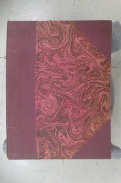
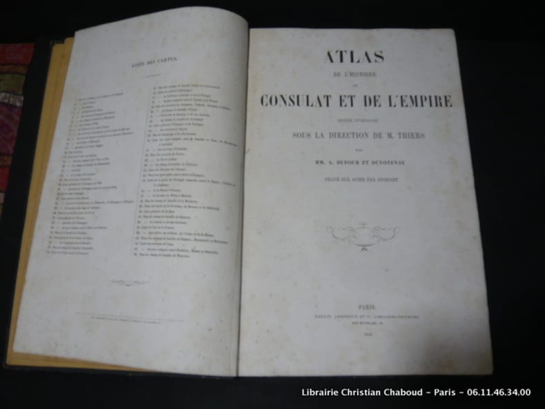
MM. A. Dufour et Duvotenay. Gravé sur acier par Duvotenay.
Atlas de l'histoire du Consulat et de l'Empire dressé et dessiné sous la direction de Monsieur Thiers par MM.A. Dufour et Duvotenay. Gravier sur Acier par Dyonnet.
Paris, Lheureux et Cie. Libraires-Editeurs., 1859, in-folio, cartonnage muet, 66 cartes. (Complet) Qq. rousseurs principalement sur la page de faux-titre et de titre. Bon exemplaire solide et complet.
Bookseller reference : 28919
|
|
|
MM.MANLEY BENDALL ET CHARLES BENARD
LES CARTES LITHO BIOLOGIQUES DU FOND DE LA MER - EXTRAIT DU BULLETIN DE GEOGRAPHIE HISTORIQUE ET DESCRIPTIVE N°2 1903.
IMPRIMERIE NATIONALE. 1903. In-8. Broché. Etat d'usage, Plats abîmés, Coiffe en pied abîmée, Intérieur frais. Paginé de 186 à 188 - déchirures sur les plats.. . . . Classification Dewey : 912-Atlas, cartes et plans
Bookseller reference : R240103655
|
|
|
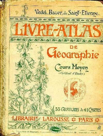
MM. Vedel, Bauer et De Saint Etienne
Livre atlas de géographie Cours moyen
Larousse. vers 1917. In-4. Relié. Etat d'usage, Couv. convenable, Dos abîmé, Intérieur frais. 56 pages augmentées de 33 gravures et 41 cartes en couleurs et en noir et blanc dans texte.. . . . Classification Dewey : 912-Atlas, cartes et plans
Bookseller reference : R260267798
|
|
|
MM. DRIOUX et LEROY Ch.
Petit Atlas Elémentaire de Géographie Moderne, à l'usage des Ecoles Primaires.
BELIN Eugène. Non daté. In-4. Cartonné. Etat d'usage, Couv. défraîchie, Dos satisfaisant, Intérieur acceptable. Album de 19 cartes, dont 11 planches (ou doubles-planches) en couleurs.. . . . Classification Dewey : 912-Atlas, cartes et plans
Bookseller reference : RO80084997
|
|
|
MMrs DRIOUX ET Ch. LEROY
AFRIQUE - EGYPTE, NUBIE ET ABYSSINE
LIBRAIRIE CLASSIQUE D'EUGENE BELIN. NON DATE. In-Plano. Broché. Etat passable, Livré sans Couverture, Dos satisfaisant, Intérieur acceptable. Carte originale 45x30 cm en couleurs. Déchirures.. . . . Classification Dewey : 912-Atlas, cartes et plans
Bookseller reference : RO30115874
|
|
|
MMrs DRIOUX ET Ch. LEROY
BASSIN DE LA MEDITERRANEE
LIBRAIRIE CLASSIQUE D'EUGENE BELIN. NON DATE. In-Plano. Broché. Etat passable, Livré sans Couverture, Dos satisfaisant, Déchirures. Carte originale 45x30 cm en couleurs.. . . . Classification Dewey : 912-Atlas, cartes et plans
Bookseller reference : RO30115876
|
|
|
MMrs DRIOUX ET Ch. LEROY
CARTE POLITIQUE ET ETHNOGRAPHIQUE DE L'ASIE
LIBRAIRIE CLASSIQUE D'EUGENE BELIN. NON DATE. In-Plano. Broché. Etat d'usage, Livré sans Couverture, Dos satisfaisant, Intérieur acceptable. Carte originale 45x30 cm en couleurs. Déchirures.. . . . Classification Dewey : 912-Atlas, cartes et plans
Bookseller reference : RO30115869
|
|
|
MMrs DRIOUX ET Ch. LEROY
CARTE PHYSIQUE ET POLITIQUE DE LA RUSSIE ET DES ETATS SCANDINAVES
LIBRAIRIE CLASSIQUE D'EUGENE BELIN. NON DATE. In-Plano. Broché. Etat d'usage, Livré sans Couverture, Dos satisfaisant, Intérieur acceptable. Carte originale 45x30 cm en couleurs.. . . . Classification Dewey : 912-Atlas, cartes et plans
Bookseller reference : RO30115871
|
|
|
MMrs DRIOUX ET Ch. LEROY
EMPIRE RUSSE
LIBRAIRIE CLASSIQUE D'EUGENE BELIN. NON DATE. In-Plano. Broché. Etat d'usage, Livré sans Couverture, Dos satisfaisant, Intérieur acceptable. Carte originale 45x30 cm en couleurs. Déchirures.. . . . Classification Dewey : 912-Atlas, cartes et plans
Bookseller reference : RO30115868
|
|
|
MMrs DRIOUX ET Ch. LEROY
EMPIRE FRANCAIS DIVISE EN 130 DEPARTEMENTS
LIBRAIRIE CLASSIQUE D'EUGENE BELIN. NON DATE. In-4. Broché. Etat passable, Livré sans Couverture, Dos satisfaisant, Déchirures. Carte originale 33x22 cm en couleurs. Très abîmée.. . . . Classification Dewey : 912-Atlas, cartes et plans
Bookseller reference : RO30115883
|
|
|
MMrs DRIOUX ET Ch. LEROY
EUROPE EN 1715
LIBRAIRIE CLASSIQUE D'EUGENE BELIN. NON DATE. In-Plano. Broché. Etat d'usage, Livré sans Couverture, Dos satisfaisant, Intérieur acceptable. Carte originale 45x30 cm en couleurs.. . . . Classification Dewey : 912-Atlas, cartes et plans
Bookseller reference : RO30115875
|
|
|
MMrs DRIOUX ET Ch. LEROY
EUROPE A L'EPOQUE DE CHARLES-QUINT
LIBRAIRIE CLASSIQUE D'EUGENE BELIN. NON DATE. In-4. Broché. Etat passable, Livré sans Couverture, Dos satisfaisant, Déchirures. Carte originale 33x22 cm en couleurs. Très abîmée.. . . . Classification Dewey : 912-Atlas, cartes et plans
Bookseller reference : RO30115882
|
|
|
MMrs DRIOUX ET Ch. LEROY
EUROPE PENDANT LA DERNIERE PERIODE DU MOYEN-AGE
LIBRAIRIE CLASSIQUE D'EUGENE BELIN. NON DATE. In-Plano. Broché. Etat d'usage, Livré sans Couverture, Dos satisfaisant, Intérieur acceptable. Carte originale 45x30 cm en couleurs.. . . . Classification Dewey : 912-Atlas, cartes et plans
Bookseller reference : RO30115866
|
|
|
MMrs DRIOUX ET Ch. LEROY
EUROPE A L'EPOQUE DES CROISADES
LIBRAIRIE CLASSIQUE D'EUGENE BELIN. NON DATE. In-Plano. Broché. Etat d'usage, Livré sans Couverture, Dos satisfaisant, Intérieur acceptable. Carte originale 45x30 cm en couleurs.. . . . Classification Dewey : 912-Atlas, cartes et plans
Bookseller reference : RO30115870
|
|
|
MMrs DRIOUX ET Ch. LEROY
EUROPE DEPUIS L'ABDICATION DE CHARLES-QUINT JUSQU'A LA FIN DE LA GUERRE DE 30 ANS
LIBRAIRIE CLASSIQUE D'EUGENE BELIN. NON DATE. In-Plano. Broché. Etat d'usage, Livré sans Couverture, Dos satisfaisant, Intérieur acceptable. Carte originale 45x30 cm en couleurs.. . . . Classification Dewey : 912-Atlas, cartes et plans
Bookseller reference : RO30115877
|
|
 Receive by email
 Download as PDF document
 RSS feed


