|
Collegiate atlas
The Collegiate atlas 1872 Leather Bound
2019. Leather Bound. New. Leather Binding on Spine and Corners with Golden Leaf Printing on round Spine. Reprinted in 2019 with the help of original edition published long back 1872. This book is printed in black & white sewing binding for longer life Printed on high quality Paper re-sized as per Current standards professionally processed without changing its contents. As these are old books we processed each page manually and make them readable but in some cases some pages which are blur or missing or black spots. If it is multi volume set then it is only single volume if you wish to order a specific or all the volumes you may contact us. We expect that you will understand our compulsion in these books. We found this book important for the readers who want to know more about our old treasure so we brought it back to the shelves. Hope you will like it and give your comments and suggestions. Lang: - English Pages 264. EXTRA 10 DAYS APART FROM THE NORMAL SHIPPING PERIOD WILL BE REQUIRED FOR LEATHER BOUND BOOKS. FOLIO EDITION IS ALSO AVAILABLE. hardcover
Bookseller reference : LB1111003282236
|
|
|
Collegiate atlas
The Collegiate atlas 1872
2020. Paperback. New. Lang: - English Pages 264. Reprinted in 2020 with the help of original edition published long back 1872. This book is Printed in black & white sewing binding for longer life with Matt laminated multi-Colour Soft Cover HARDCOVER EDITION IS ALSO AVAILABLE Printed on high quality Paper re-sized as per Current standards professionally processed without changing its contents. As these are old books we processed each page manually and make them readable but in some cases some pages which are blur or missing or black spots. If it is multi volume set then it is only single volume if you wish to order a specific or all the volumes you may contact us. We expect that you will understand our compulsion in these books. We found this book important for the readers who want to know more about our old treasure so we brought it back to the shelves. Any type of Customisation is possible with extra charges. Hope you will like it and give your comments and suggestions. paperback
Bookseller reference : PB1111003282236
|
|
|
Collegiate atlas
The Collegiate atlas 1872 Hardcover
2020. Hardcover. New. Lang: - English Pages 264. Reprinted in 2020 with the help of original edition published long back 1872. This book is Printed in black & white Hardcover sewing binding for longer life with Matt laminated multi-Colour Dust Cover Printed on high quality Paper re-sized as per Current standards professionally processed without changing its contents. As these are old books we processed each page manually and make them readable but in some cases some pages which are blur or missing or black spots. If it is multi volume set then it is only single volume if you wish to order a specific or all the volumes you may contact us. We expect that you will understand our compulsion in these books. We found this book important for the readers who want to know more about our old treasure so we brought it back to the shelves. Any type of Customisation is possible with extra charges. Hope you will like it and give your comments and suggestions. hardcover
Bookseller reference : 1111003282236
|
|
|
COLLERCTIF
CARTE EN COULEURS DE LA GIRONDE ECHELLE 1/400 000.
GIRARD ET BARRERE. NON DATE. In-Plano. En feuillets. Bon état, Livré sans Couverture, Dos satisfaisant, Intérieur acceptable. Une carte en couleurs de 32.5 x 50 cm.. . . . Classification Dewey : 912-Atlas, cartes et plans
Bookseller reference : R160132852
|
|
|
Collet (J.)
Feuille XV, Charleroi.
français Institut cartographique militaire, 1907. Collée sur toile et pliée (52x44 cm), de 12 panneaux. Topogravé et imprimé à l'Institut cartographique militaire en 1907. Avec les étiquettes de l'éditeur sur les plats. Dessins au 40000e de J. Collet. En bon état.
|
|
|
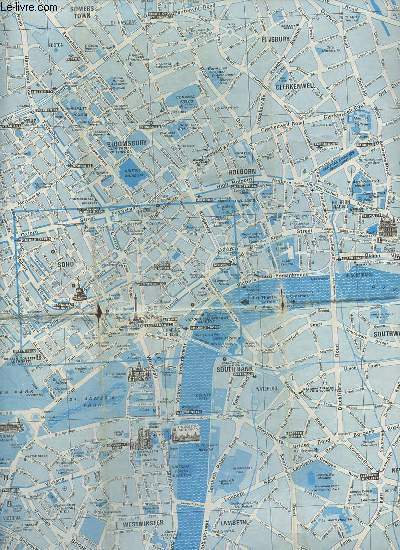
Colletif
Un plan de Londres à l'usage des touristes en couleur dépliant d'environ 60 x 41,5 cm.
British tourist authority. 1973. In-Plano. En feuillets. Etat d'usage, Livré sans Couverture, Dos satisfaisant, Pliures. Un plan de Londres à l'usage des touristes en couleur dépliant d'environ 60 x 41,5 cm - texte + un plan du métro londonien en couleur + un plan en couleur des alentours de Londres en couleur au dos.. . . . Classification Dewey : 912-Atlas, cartes et plans
Bookseller reference : R320165765
|
|
|
Collexctif
Une carte touristique des magasins J.
Promos Publicité. non daté. In-Plano. En feuillets. Bon état, Couv. convenable, Dos satisfaisant, Intérieur frais. Une carte touristique des magasins J - carte en couleur dépliante recto/verso d'environ 65 x 49.5 cm.. . . . Classification Dewey : 912-Atlas, cartes et plans
Bookseller reference : R320180829

|
|
|
COLLEXIONI DEL MUSEO CORRER VENEZIA - MUSEO DEL TOPKAPI - ISTANBUL.
Portolani e carte nautiche XIV-XVIII secolo dalle collezioni del Museo Correr - Venezia e Museo del Topkapi - Istanbul.= Istanbul Topkapi Sarayi Müzesi ve Venedik Correr Müzesi koleksiyonlarindan XIV-XVIII. yüzyil portolan ve deniz haritalari.
New English Paperback. Pbo. 4to. (28 x 21 cm). In Italian and Turkish. 170 p., color ills. In Turkish and Italian. Portolani e carte nautiche XIV-XVIII secolo dalle collezioni del Museo Correr - Venezia e Museo del Topkapi - Istanbul.= Istanbul Topkapi Sarayi Müzesi ve Venedik Correr Müzesi koleksiyonlarindan XIV-XVIII. yüzyil portolan ve deniz haritalari.
|
|
|
Collin'S Atlas
The " Times " Atlas of the World World Atlas
Collin'S. Hardcover. 0723010838 UK BASED SELLER SHIPS DAILY. . Very Good. Collin'S hardcover
Bookseller reference : UU0040938 ISBN : 0723010838 9780723010838
|
|
|
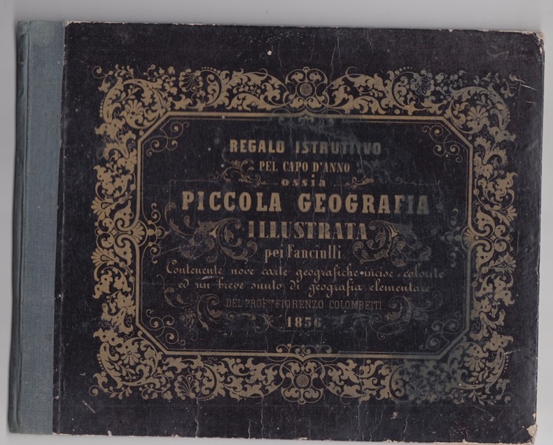
Colombetti, Fiorenzo
Piccola geografia illustrata pei fanciulli per servire d'introduzione a questo studio, contenente nove carte accuratamente incise e colorite, ed un gran numero di svariati esercizi orali di geografia e di esercizi grafici sulla descrizione delle carte in rapporto con analoghi quaderni cartografici / del professore Fiorenzo Colombetti
1855 Torino : Tipografia di G. B. Paravia e compagnia, 1855 - album in8 oblong,couverture cartonnée imprimée datée 1856, 24 p., [9] carte di tav. : carte geografiche ; 17 x 22 cm, bon état,trés rare atlas de géographie scolaire de 9 cartes coloriées et texte en regard.
Bookseller reference : 24626
|
|
|
Colombo, Marta. (Direzione editoriale)
Atlante delle Coste d'Italia. 1 : 250 000. Dedicato a chi ama il mare.
Novara., Legenda sri., 2006. Con Costa Azzurra, Corsica e Istria. Porti, spiagge, tipi di costa, profondità, linee di navigazione, fari, curiosità naturali, attrativeturistiche, campeggi, diving center, punti di immersione. Tutte le isole a una scala di grande dettaglio. ... . 256 Seiten mit zahlreichen Karten und Abbildungen (Fotografien). Zustand: Einbandkanten sehr minimal berieben. 4°. S OKarton.
Bookseller reference : 062144 ISBN : 885390058
|
|
|
COLONEL PERRIER & COLLECTIF
Carte entoilée de Moustier et Versailles, 6e Compagnie.
DEPOT DE LA GUERRE. 1882. In-12. En feuillets. Bon état, Livré sans Couverture, Dos satisfaisant, Intérieur acceptable. Carte dépliante entoilée, en couleurs, de 78 x 99 cm. Echelle 1 / 20000. . . A l'italienne. Classification Dewey : 912-Atlas, cartes et plans
Bookseller reference : RO80119639
|
|
|
Color Atlas of Diseases and Disorders of Cattle Roger Blowey and A. David Weaver Weaver
Color Atlas of Diseases and Disorders of Cattle Roger Blowey and A. David
New. unknown
Bookseller reference : 810939 ISBN : 0723432058 9780723432050

|
|
|
Color Atlas of Microbiology
R.J. Olds Binding Unknown 1975
Hardcover. GOOD. hardcover
Bookseller reference : 12345045972 ISBN : 0815165420 9780815165422
|
|
|
Colton's Condensed Octavo Atlas of the Union
MAP OF ARKANSAS AND INDIAN TERRITORY
New York: J. H. Colton 1865. Colored engraved map with a bit of creasing at the fold. 11 3/4 x 9 1/2". From the second edition of Colton's Condensed Octavo Atlas of the Union. J. H. Colton unknown books
Bookseller reference : 291812

|
|
|
Colton's Condensed Octavo Atlas of the Union
MAP OF COLORADO AND NEW MEXICO
New York: J. H. Colton 1865. Colored engraved map with a bit of creasing at the fold. 11 3/4 x 9 1/2". From the second edition of Colton's Condensed Octavo Atlas of the Union. J. H. Colton unknown books
Bookseller reference : 291814

|
|
|
Colton's Condensed Octavo Atlas of the Union
MAP OF EAST AND WEST VIRGINIA
New York: J. H. Colton 1865. Colored engraved map with a bit of creasing at the fold. 11 3/4 x 9 1/2". From the second edition of Colton's Condensed Octavo Atlas of the Union. J. H. Colton unknown books
Bookseller reference : 291808

|
|
|
Colton's Condensed Octavo Atlas of the Union
MAP OF FLORIDA
New York: J. H. Colton 1865. Second Edition. Colored engraved map with a bit of creasing at the fold. 11 3/4 x 9 1/2". From the second edition of Colton's Condensed Octavo Atlas of the Union. J. H. Colton unknown books
Bookseller reference : 291849

|
|
|
Colton's Condensed Octavo Atlas of the Union
MAP OF GEORGIA AND ALABAMA
New York: J. H. Colton 1865. Second Edition. Colored engraved map with a bit of creasing at the fold. 11 3/4 x 9 1/2". From the second edition of Colton's Condensed Octavo Atlas of the Union. J. H. Colton unknown books
Bookseller reference : 291850

|
|
|
Colton's Condensed Octavo Atlas of the Union
MAP OF ILLINOIS
New York: J. H. Colton 1865. Colored engraved map with a bit of creasing at the fold. 11 3/4 x 9 1/2". From the second edition of Colton's Condensed Octavo Atlas of the Union. J. H. Colton unknown books
Bookseller reference : 291809

|
|
|
Colton's Condensed Octavo Atlas of the Union
MAP OF INDIANA AND OHIO
New York: J. H. Colton 1865. Second Edition. Colored engraved map with a bit of creasing at the fold. 11 3/4 x 9 1/2". From the second edition of Colton's Condensed Octavo Atlas of the Union. Some pencil marks on the recto and the verso. J. H. Colton unknown books
Bookseller reference : 291854

|
|
|
Colton's Condensed Octavo Atlas of the Union
MAP OF IOWA AND MINNESOTA
New York: J. H. Colton 1865. Colored engraved map with a bit of creasing at the fold. 11 3/4 x 9 1/2". From the second edition of Colton's Condensed Octavo Atlas of the Union. J. H. Colton unknown books
Bookseller reference : 291811

|
|
|
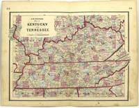
Colton's Condensed Octavo Atlas of the Union
MAP OF KENTUCKY AND TENNESSEE
New York: J. H. Colton 1865. Second Edition. Colored engraved map with a bit of creasing at the fold. 11 3/4 x 9 1/2". From the second edition of Colton's Condensed Octavo Atlas of the Union. J. H. Colton unknown books
Bookseller reference : 291852
|
|
|
Colton's Condensed Octavo Atlas of the Union
MAP OF MARYLAND DELAWARE & VIRGINIA
New York: J. H. Colton 1865. Colored engraved map with a bit of creasing at the fold. 11 3/4 x 9 1/2". From the second edition of Colton's Condensed Octavo Atlas of the Union. J. H. Colton unknown books
Bookseller reference : 291807

|
|
|
Colton's Condensed Octavo Atlas of the Union
MAP OF MICHIGAN AND WISCONSIN
New York: J. H. Colton 1865. Colored engraved map with a bit of creasing at the fold. 11 3/4 x 9 1/2". From the second edition of Colton's Condensed Octavo Atlas of the Union. Some pencil marks on the verso. J. H. Colton unknown books
Bookseller reference : 291810

|
|
|
Colton's Condensed Octavo Atlas of the Union
MAP OF MISSISSIPPI AND LOUISIANA
New York: J. H. Colton 1865. Second Edition. Colored engraved map with a bit of creasing at the fold. 11 3/4 x 9 1/2". From the second edition of Colton's Condensed Octavo Atlas of the Union. J. H. Colton unknown books
Bookseller reference : 291851

|
|
|
Colton's Condensed Octavo Atlas of the Union
MAP OF MISSOURI AND KANSAS
New York: J. H. Colton 1865. Second Edition. Colored engraved map with a bit of creasing at the fold. 11 3/4 x 9 1/2". From the second edition of Colton's Condensed Octavo Atlas of the Union. J. H. Colton unknown books
Bookseller reference : 291853

|
|
|
Colton's Condensed Octavo Atlas of the Union
MAP OF NEVADA UTAH AND ARIZONA
New York: J. H. Colton 1865. Second Edition. Colored engraved map with a bit of creasing at the fold. 11 3/4 x 9 1/2". From the second edition of Colton's Condensed Octavo Atlas of the Union. J. H. Colton unknown books
Bookseller reference : 291848

|
|
|
Colton's Condensed Octavo Atlas of the Union
MAP OF NORTH CAROLINA & SOUTH CAROLINA
New York: J. H. Colton 1865. Colored engraved map with a bit of creasing at the fold. 11 3/4 x 9 1/2". From the second edition of Colton's Condensed Octavo Atlas of the Union. J. H. Colton unknown books
Bookseller reference : 291813

|
|
|
Colton's Condensed Octavo Atlas of the Union
MAP OF OREGON AND WASHINGTON
New York: J. H. Colton 1865. Colored engraved map with a bit of creasing at the fold. 11 3/4 x 9 1/2". From the second edition of Colton's Condensed Octavo Atlas of the Union. This map with some creasing at the fold. J. H. Colton unknown books
Bookseller reference : 291816

|
|
|
Colton's Condensed Octavo Atlas of the Union
MAP OF TEXAS
New York: J. H. Colton 1865. Second Edition. Colored engraved map with a bit of creasing at the fold. 11 3/4 x 9 1/2". From the second edition of Colton's Condensed Octavo Atlas of the Union. This map is darkened as if from newsprint. Wheat in Mapping the Transmississippi West notes of this map of Texas in the 1864 first printing that the eastern boundary of New Mexico is pushed too far to the east placing it in Texas proper; that appears to be the case with this second printing as well. J. H. Colton unknown books
Bookseller reference : 291856

|
|
|
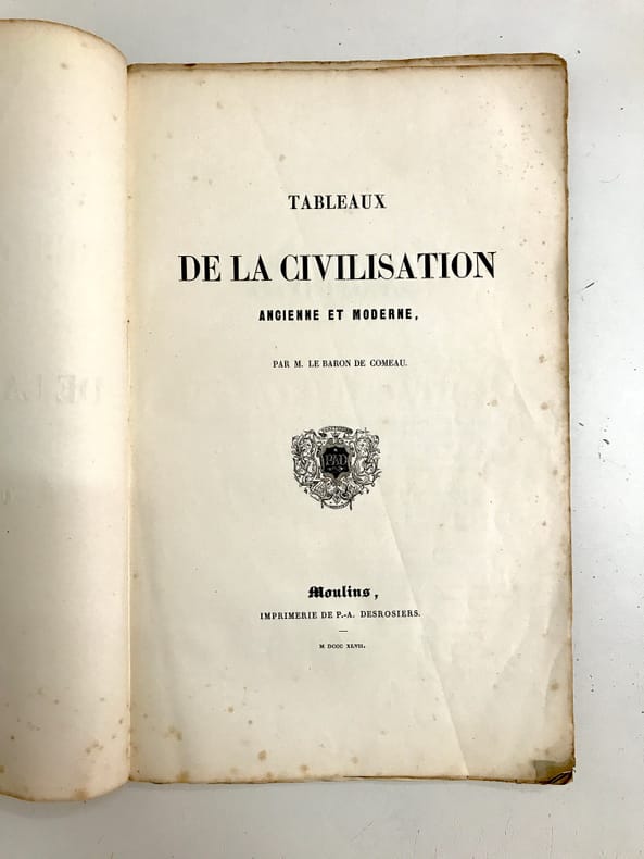
COMEAU (le baron Sébastien-Joseph de)
Tableaux de la civilisation ancienne et moderne.
Moulins, Desrosiers, 1847. album in-folio (28 x 45 cm), 2ff.-45pp.-1f.- 19 pièces hors-texte. Broché, couverture de papier beige, muette avec étiquette sur le plat.
Bookseller reference : 34793
|
|
|
Comer Stuart & Douglas Crimp Douglas Dunn Lia Gangitano Charles Atlas
Charles Atlas
Prestel USA. New. 2015. Hardcover. Pictorial boards. Quarto. 303 pp. Profusely illustrated. In publisher's shrinkwrap. New. Subject: Art & Graphic Design Prestel USA hardcover
Bookseller reference : Qnew01217 ISBN : 3791381008 9783791381008

|
|
|
Comer Stuart; Crimp Douglas; Dunn Douglas; Gangitano Lia; Atlas Charles
Charles Atlas
Prestel USA 2015-02-03. Hardcover. Like New. Ships Within 48 hours M-F. LIKE NEW/UNREAD!!! Text is Clean and Unmarked! Has a small black line on the bottom/exterior edge of pages. Prestel USA hardcover
Bookseller reference : PS-HC39-LN-3791381008 ISBN : 3791381008 9783791381008

|
|
|
Comer Stuart & Douglas Crimp & Douglas Dunn & Lia Gangitano & Charles Atlas & Johanna Fateman
Charles Atlas
Prestel USA. New. 2015. Hardcover. 3791381008 . FREE UPGRADE to Courier/Priority Shipping Upon Request - IN STOCK AND IMMEDIATELY AVAILABLE FOR SHIPMENT - Flawless copy brand new pristine never opened - Prestel USA hardcover
Bookseller reference : 110857 ISBN : 3791381008 9783791381008
|
|
|
COMITE D'EXPANSION ECONOMIQUE ET SOCIALE
ATLAS DE LA REGION POITOU CHARENTES - TOME 1.
COMITE D'EXPANSION ECONOMIQUE ET SOCIALE DU CENTRE OUEST. 1964. In-Folio. Broché. Etat d'usage, Tâchée, Dos satisfaisant, Intérieur acceptable. Environ 90 pages - tampon sur la page de titre - textes sur deux colonnes - nombreuses cartes en couleurs hors texte - 2 photos disponibles.. . . . Classification Dewey : 912-Atlas, cartes et plans
Bookseller reference : R240083057
|
|
|
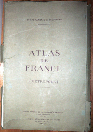
Comité national de géographie ; Margerie, Emmanuel de (préf.) ; Perret, Robert (dir.)
Atlas de France (métropole)
1959 Paris, Centre national de la recherche scientifique (CNRS), Editions géographiques de France, sd [1959]. 50 x 32 cm, grand in-folio, 4 ff. + 80 cartes à doubles page réhaussées de couleurs légendées au recto, en feuilles sous portefeuille vert de l'éditeur.
Bookseller reference : 658
|
|
|
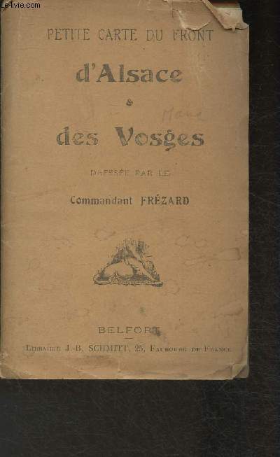
Commandant Frézard
Petite carte du front- d'Alsace & des Vosges
Belfort. Non daté. In-Folio. Broché. Bon état, Couv. défraîchie, Dos satisfaisant, Intérieur frais. 1 carte en couleurs.. . . . Classification Dewey : 912-Atlas, cartes et plans
Bookseller reference : RO30320848
|
|
|
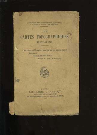
COMMANDANT SIRON ET CAPITAINE GILLIARD.
LES CARTES TOPOGRAPHIQUES BELGES.
Librarie Chapelot.. 1917.. In-8. Broché. Etat passable, Couv. légèrement passée, Dos abîmé, Quelques rousseurs. 147 pages. Nombreuses illustrations en noir et blanc, dans le texte. Dos détaché. Coiffes abîmées.. . . . Classification Dewey : 912-Atlas, cartes et plans
Bookseller reference : RO20077105
|
|
|
Committee For The World Atlas Of Agriculture
World Atlas Of Agriculture Under To Aegis Of The International Association Of Agricultural Economics Volume 2
Istituto Geografico De Agostini 1973. Volume 2. This is an ex-library book and may have the usual library/used-book markings inside.This book has hardback covers. In good all round condition. No dust jacket. Please note the Image in this listing is a stock photo and may not match the covers of the actual item3400grams ISBN: Istituto Geografico De Agostini hardcover
Bookseller reference : 5739174
|
|
|
Compact Atlas
Compact World Atlas
East Rutherford New Jersey U.S.A.: DK Pubublishing Inc. 2003. Book. Very Good. Soft cover. 4to - over 9�" - 12" tall. DK Pubublishing, Inc. Paperback
Bookseller reference : 27980 ISBN : 0789493578 9780789493576

|
|
|
Compagnie Universelle du canal interocéanique de Panama.
Tracé du canal et situation des travaux en cours d'éxécution au 1er juin 1884.
français Feuillet plié en quatre. 33x50 cm. Gravé et imprimé par Erhard. Supplément au N° 119 du Bulletin du Canal Interocéanique.
|
|
|
Company Atlas Model Railroad
The Atlas Beginner's Guide to HO Model Railroading
Atlas Model Railroad Company. Atlas Model Railroad Company. The Atlas Beginner's Guide to HO Model Railroading. Hillside New Jersey: Atlas Model Railroad Company 2003. 47pp. Illustrated. 4to. Illustrated stapled wraps. Book condition: Very good. . Very Good. 2003. Atlas Model Railroad Company paperback
Bookseller reference : UATLATL00EF
|
|
|
Company Title Atlas
Atlas of Clay and Union Counties: Containing Maps Plats of the Townships Rural Directory Pictures of Schools Churches Articles on Agriculture Etc. South Dakota
Minneapolis: Title Atlas Company 1960. SPIRAL_BOUND. Good. 1959-1960 Edition. Clean has a good binding no marks or notations. Only minor wear. Scarce book full of information. Spiral-bound. Ships from our bookstore in West Columbia S.C. Title Atlas Company unknown
Bookseller reference : SKU1033513

|
|
|
Company Title Atlas
Atlas of Clay and Union Counties: Containing Maps Plats of the Townships Rural Directory Pictures of Schools Churches Articles on Agriculture Etc. South Dakota
Minneapolis: Title Atlas Company 1960. SPIRAL_BOUND. Good. 1959-1960 Edition. Clean has a good binding no marks or notations. Only minor wear. Scarce book full of information. Spiral-bound. Ships from our bookstore in West Columbia S.C. Title Atlas Company unknown books
Bookseller reference : SKU1033513
|
|
|
Compere, Tom (Editor).
THE AIR FORCE BLUE BOOK. Volume 1.
382p. Edges of paper beginning to brown. 8vo. Paperback. AIR/1
|
|
|
Compiled and drawn under the direction of [LIEUTENANT COLONEL] F. J. SALMON, (Director of Land Registration and Surveys, Cyprus, 1932).
[SALMON'S MAP OF CYPRUS] Survey of Cyprus administration map. Scale of 4 miles to one inch = 1/253440.
Very Good English Revised Third Edition of this rare map of Cyprus, made by Salmon, who was the director of Cypriot land registration and surveys. "Shows grid, district boundaries, heights in feet, railways, roads (2 categories), antiquities, ancient sites.". / "Shows district boundaries, towns and cities, roads (2 categories), railroads, ancient sites and antiquities, and dry streams. Relief is shown by contours, gradient tints, and spot heights. Earlier Edition: 1952.". (OCLC). "In December 1926, in a memorandum to the Colonial Office on vacant surveying positions in the colonies, Palestine and Cyprus were mentioned at the end of a group of Mediterranean colonies; that is there was a group of Mediterranean colonies, and also Cyprus and Palestine [.] Only in 1929 was an Imperial project involving Palestine and Transjordan, brought up at the committee (Colonial Survey Committee). This was the experimental aerial survey for determining the route of the Haifa - Damascus railway, which was presented as a model for mapping from aerial photographs [.] Among the important things reported to the Colonial Survey Committee was the reconnaissance conducted by Colonial Winterbotham, the Chief of the GSGS, in the survey departments of the colonies in 1929, a trip that had been encouraged in the first Conference of Empire Survey Officers in 1928 [.] ... how much Salmon [F. J.] expected from Winterbotham's visit to Ceylon a short time before he was to take over the directorship of the small survey department of Cyprus.". (Source: The Survey of Palestine Under the British Mandate, 1920-1948). Original color map. Folded in original wrappers. Fine. Elephant folio. (58 x 89 cm). In English. Survey of Cyprus administration map. Scale of 4 miles to one inch = 1/253440. Compiled and drawn under the direction of F. J. SALMON, (Director of Land Registration and Surveys, Cyprus, 1932). Revised Third Edition. Second in 1950.
|
|
|
Compiled by Title Atlas Company
Atlas of Fillmore County Nebraska -- Containing Maps Plats of the Townships Rural Directory Pictures of Farms and Families Articles about History Etc.
Title Atlas Company 1977. Trade Paperback -- Spiral Bound -- Folio - over 12" - 15" tall -- Very Good -- Clean and tight with only lightest of wear. Containing Maps Plats of the Townships Rural Directory Pictures of Farms and Families Articles about History Etc. Trade Paperback. Very Good. Folio - over 12" - 15" tall. Title Atlas Company Paperback
Bookseller reference : 324203
|
|
|
Compiler Hammond World Atlas
The World Almanac 2004 Notebook Atlas
Amer Map Co 2004-03-31. Paperback. Good. Amer Map Co paperback
Bookseller reference : SONG0843719613 ISBN : 0843719613 9780843719611

|
|
|
Compliments of the Cunard Line; Compiled by Atlas Advertising Agency
Springs of Health in Great Britain and France
NY: Gaines Thurman 1917. First edition. Hardcover. Good Minus. Color illustratred paper over boards with edgwe wear and rubbing spine has three pieces of cellphane tape althogh the book is well bound. Clean and unmarked with still bright pages many b/w photographs. 104 pages. <br/><br/> Gaines Thurman hardcover
Bookseller reference : 10429
|
|
 Receive by email
 Download as PDF document
 RSS feed


