|
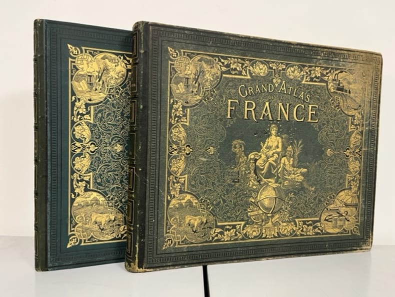
FALLEX M., GIBERT A.
NOUVEL ATLAS CLASSIQUE
Librairie Delagrave. 1935. In-4 Carré. Relié. Etat d'usage. Couv. défraîchie. Dos abîmé. Intérieur acceptable. 79 pages. Cartes en couleur en frontispice. Illustré de nombreuses cartes en couleur et en noir et blanc, dans et hors texte. Dos muet. Légères mouillures sur les coins supérieurs. 8e édition mise à jour. 104 cartes et cartons.

|
|
|
FALLEX M., GIBERT A.
NOUVEL ATLAS CLASSIQUE
Librairie Delagrave. 1949. In-4 Carré. Relié. Etat d'usage. Couv. légèrement passée. Dos frotté. Intérieur acceptable. 79 pages. Cartes en couleur en frontispice. Illustré de nombreuses cartes en couleur et en noir et blanc, dans et hors texte. Dos muet. Nouvelle édition refondue. 111 cartes et cartons.

|
|
|
Fallex, Gibert (A.), Ozouf (R.)
Géographie (troisième année). La France et ses colonies.
français Petit in-4 de 95 pp.; dos toilé, plats cartonnés imprimés (album de l'éditeur). Texte et illustrations sur deux colonnes.
|
|
|
Family World Atlas Rand McNally and Company Company
Family World Atlas Rand McNally and
Very Good. Very good; LARGE HARDCOVER-NAVY COVER WITH WHITE LETTERING--1978 COPYRIGHT. hardcover
Bookseller reference : 0042 ISBN : 0528836730 9780528836732
|
|
|
FARRINGTON KAREN
ATLAS HISTORIQUE DES GRANDES EXPEDITIONS DE LA DECOUVERTE DES AMERIQUES PAR LES VIKINGS AUX DERNIERES EXPLORATIONS SCIENTIFIQUES EN ANTARTICQUE - LES PREMIERES EXPEDITIONS / LES VOYAGES AVANT 1600 / L ASIE APRES 1600 / L AFRIQUE DEPUIS 1600 / ETC.
EDITION DE LA SEINE. 2006. In-4. Relié. Bon état, Couv. convenable, Dos satisfaisant, Intérieur frais. 189 pages augmentées de nombreuses planches en couleur et noir et blanc dans et hors texte - Jaquette en bon etat - Protection plastique.. . . . Classification Dewey : 912-Atlas, cartes et plans
Bookseller reference : R260186576
|
|
|
Farley, A.L.
Atlas of British Columbia: People, Environment and Resource Use
136 pages. "An indispensable reference tool for government officials, businessmen, investors, industrialists, teachers, students, librarians, environmentalists, and all people with a fundamental interest in the past, present, and future development of British Columbia." - from dust jacket. Book clean and unmarked with moderate wear. Moderate wear to dust jacket which is preserved in mylar and is neatly taped to boards.. Sound copy of this handsome work. Book

|
|
|
Fassbender, Karl. Kebschull, Dietrich. (Editor). Voss, Frithjof. (Bearbeiter)
Kalimantan Timur. East Kalimantan Indonesia. Atlas.
Hamburg., HWWA - Institut für Wirtschaftsforschung Hamburg., 1982. (Herausgeber) East Kalimantan Transmigration Area Developement Project (TAD). TAD, a Project for Technical Cooperation between the Republic of Indonesia and the Federal Republic of Germany. Eine Seite Einführung (in Englisch), enthält 52 farbige Karten, Tabellen, Skizzen auf 41 Seiten. Zustand: ausgeschiedenes Bibliotheksexemplar, Vorsatz, titelblatt und Einleitung mit Bibliotheksstempel, teilweise mit Inventarnummer. Vorderer oberer Einbanddeckel mit minimalen Kratzspuren (unscheinbar). Quer-2°. S Kunststoff / Kunstledereinband
Bookseller reference : 041984
|
|
|
FAUQUEMBERG DAVID - SUBTIL JULIE
GEOGUIE SELECTION. BARCELONE ET LA CATALOGNE. EDITION SPECIALE 2006. BARCELONE ET LA CATALOGNE EN AMOUREUX. BARCELONE ET LA CATALOGNE AVEC DES ENFANTS. BARCELONE ET LA CATALOGNE POUR UN LONG WEEK END. BARCELONE ET LA CATALOGNE HORS DES SENTIERS BATTUS.
GUIDES GALLIMARD. 2006. In-12. Broché. Bon état, Couv. convenable, Dos satisfaisant, Intérieur frais. 120 pages augmentées de nombreuses cartes et photos en couleur dans et hors texte.. . . . Classification Dewey : 912-Atlas, cartes et plans
Bookseller reference : RO80171331
|
|
|
Fehn, Hans. (Hrsg.)
Luftbildatlas Bayern. Eine Landeskunde in 72 farbigen Luftaufnahmen auf Kunstdrucktafeln sowie einer Übersichtskarte. Luftbilder von Lothar Beckel.
München/Neumünster, List/Wachholtz., 1973. 4°. [26 : 33,5 cm]. 177 Seiten. Mit einem Register. Originalleinenband mit goldgeprägter Deckelvignette (Bayernwappen), goldgeprägtem Rückentitel und farbig illustriertem Schutzumschlag. - Ein sehr gut erhaltenes, makelloses Exemplar; druckfrisch. 1. Auflage.
Bookseller reference : 57202AB

|
|
|
Fenouil
Carte routière & vicinale du département de l'Hérault dressée sous l'administration de J. M. Pietri Préfet, sous la direction de M. Fenouil, Agent voyer en chef.
français Arrondissement de Béziers ( 9 cartes, 1864). - Arrondissement de Lodève (6 cartes, 1862). - Arrondissement de Saint-Pons (6 cartes, 1862). - Arrondissement de Montpellier (8 cartes, 1862). Chaque carte entoilée divisée en 9 panneaux mesure 46 x 58,5 cm. Chaque arrondissement sous étui cartonné réuni sous coffret de l'époque. Il manque la 6e carte de l'arrondissement de Béziers (Pézenas et alentours). Rare.
|
|
|
FERRAS (Robert).
Atlas d'Espagne. (Trilingue français, espagnol, anglais).
Fayard/Reclus, 1986, in-4°, 96 pp, très nombreuses cartes en noir et en couleurs, cart. éditeur
Bookseller reference : 16290
|
|
|
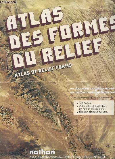
Fernarnd Nathan
Brochure publicitaire - Atlas des formes du relief - 192 pages - 200 cartes
Nathan. Non daté. In-4. Broché. Bon état, Couv. convenable, Dos satisfaisant, Intérieur frais. Brochure publicitaire de 6 pages illustrées en couleurs.. . . . Classification Dewey : 912-Atlas, cartes et plans
Bookseller reference : RO80215199
|
|
|
FERNAND DAGUIN
CARTE GEOLOGIQUE PROVISOIRE DE LA REGION PRERIFAINE.
INSTITUT CARTOGRAPHIQUE DE PARIS. 1927. In-8. Broché. Etat d'usage, Couv. partiel. décollorée, Dos abîmé, Intérieur frais. Carte dépliante illustrée en couleurs de 110 x 70 cm. Premier plat détaché.. . . . Classification Dewey : 912-Atlas, cartes et plans
Bookseller reference : R260154521
|
|
|
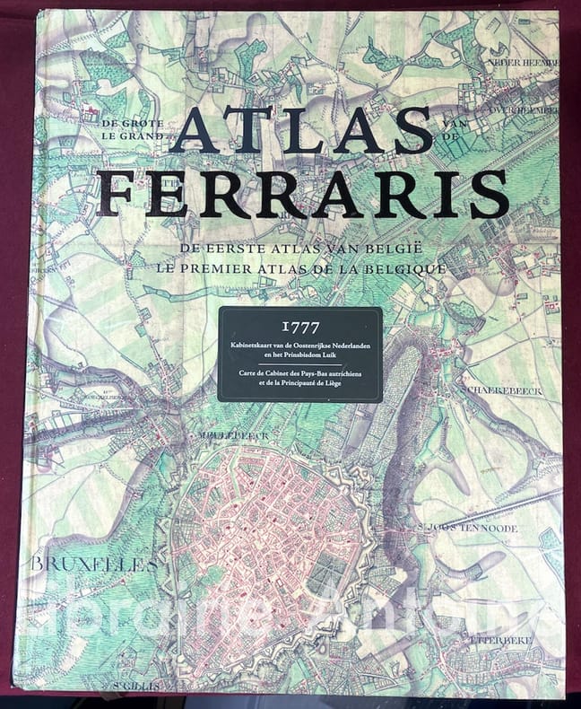
FERRARIS (Joseph de)
Le grand atlas de Ferraris. Le premier atlas de Belgique.
Lannoo - Racine - IGN - KBR 2011 In-folio (h. 42 cm.) 608 pp. couverture cartonnée illustrée.
Bookseller reference : 3979
|
|
|
FERRAND M. H.
LES ATLAS FRANCAIS - EXTRAIT DES COMPTES RENDUS DE L'ASSOCIATION FRANCAISE POUR L'AVANCEMENT DES SCIENCES - CONGRES DE GRENOBLE 1904.
SECRETARIAT DE L'ASSOCIATION. 1904?. In-8. Broché. Etat d'usage, Tâchée, Dos satisfaisant, Intérieur frais. 10 pages - 1 tache brune en tête.. . . . Classification Dewey : 912-Atlas, cartes et plans
Bookseller reference : RO20178202
|
|
|
FERRAND Henri.
Les atlas français.
L'atlas de Tavernier publié en 1643, Hötel des sociétés savantes, Paris 1904. Plaquette grand in-8 (24x15). 10 pages. Cartonnage papier moiré de l'époque, pièce de titre rouge, couvertures conservées.
Bookseller reference : 10879
|
|
|
Fernald, James C.; Vizetelly, Frank H
The Handy Standard Dictionary and Atlas Designed To Give The Orthography, Pronunciation, And Meaning of About 38,000 Terms In The English Language, Together With Faulty Diction, Foreign Words and Phrases And A Gazetteer Of The World With Pronunciations, Descriptions, And Populations Of The Names Recorded and Much Indispensable Information On Coinage, Weights And Measures, Poisons And Antidotes, Rulers Of The World etc. 780 pictorial illustrations.
New York a. o., Funk & Wagnalls Company, 1933. original soft cover, small 8vo, 588 pages with numerous pictorial illustrations, atlas is missing!, cover a little bit worn, apart from that good copy
Bookseller reference : ED8-785

|
|
|
FESTSCHRIFT ISENBIKE TOGAN, (1940-).
Horizons of the world: Festschrift for Isenbike Togan.= Hûdudü'l-âlem: Isenbike Togan'a armgan. Edited by Ilker Evrim Binbas, Nurten Kiliç-Schubel.
New English Paperback. Roy. 8vo. (24 x 17 cm). In English and Turkish. 630 p., ills. Horizons of the world: Festschrift for Isenbike Togan.= Hûdudü'l-âlem: Isenbike Togan'a armgan. Edited by Ilker Evrim Binbas, Nurten Kiliç-Schubel. The articles gathered in this volume are dedicated to Professor Isenbike Togan by her students, colleagues, and friends to honor and celebrate her long and continuing career as one of the world's foremost scholars in the field of Central Asian history. The range of articles that the contributors to this festschrift submitted reflects in many ways the depth and breadth of Isenbike Togan's works and her understanding of history. Indeed, from a geographical perspective, her published works cover the vast area from China to Anatolia, and from a chronological perspective they extend from the 7th to the 21st century. While the central historical question with which Isenbike Togan engages most frequently is the nature of political culture, her books and articles address a wide range of issues and questions, including women's history, the dhikr ceremonies of the Naqshbandi order in Eastern Turkestan, legitimacy and state formation in Central Asia, tribal politics from the perspective of anthropological history, and Chinese historiography. Through her command of a wide range of languages, historical issues, and textual sources, she not only makes 'surprising' connections among these seemingly diverse historical topics, but offers systematic and new approaches in the study of the Turco-Mongol peoples. Her intellectual adventure has been shaped by her unique ability to engage with the objects of her inquiry in a truly holistic and integrative manner; her works, while thoroughly rooted in painstaking and careful textual and linguistics analysis, consistently address and illuminate the 'big picture' in history.
|
|
|
Fezer, Fritz und Uwe Muuss
Luftbildatlas Baden-Württemberg. Eine Landeskunde in 72 farbigen Luftaufnahmen auf Kunstdrucktafeln sowie einer Übersichtskarte.
München/Neumünster, List/Wachholtz., 1971. 4°. [26 : 33,5 cm]. 177 Seiten. Mit einem Register. Originalleinenband mit goldgeprägter Deckelvignette (Landeswappen), goldgprägtem Rückentitel und farbig illustriertem Schutzumschlag. - Ein sehr gut erhaltenes, makelloses Exemplar; druckfrisch. 1. Auflage.
Bookseller reference : 57203AB

|
|
|
Fiedler, Franz (Herausgeber)
Klimaatlas Oberrhein Mitte-Süd. Atlas climatique du fossé rhénan méridional. REKLIP, Regio-Klima-Projekt
Offenbach, IFG, Inst. für Angewandte Geowiss. 1995. xiv, 212, 17, 11 Seiten. Softcover/Paperback
Bookseller reference : 100750

|
|
|
FIGUIER Louis
La Terre avant le Déluge
HACHETTE L. & Cie. 3ème édition. 1864. In-8. Relié demi-cuir. Etat d'usage, Couv. légèrement passée, Dos satisfaisant, Quelques rousseurs. 486 pages. Frontispice en couleurs, hors-texte. Nombreuses illustrations en noir et blanc dans le texte et hors-texte. Quelques cartes en couleurs, hors-texte. Titre et filets dorés sur le dos cuir noir. Coins et tranches des plats frottés. Quelques déchirures. Epidermures sur le cuir.. . . . Classification Dewey : 912-Atlas, cartes et plans
Bookseller reference : RO80020739
|
|
|
FILLION L. Cl
atlas archéologique de la Bible daprès les meilleurs documents soit anciens soit modernes
et surtout d'apres les decouvertes les plus recentes faites dans la palestine , la Syrie , la Phenecie l'Egypte et l'Assyrie Librairie Briday , Delhomme et Briguet 1883 , reliure demi maroquin , dos à nerfs , bon etat , a regretter des rousseurs , rare en premiere edition , in 4 tres illustré de planches pleine page
Bookseller reference : 3667
|
|
|
FILLION (M. L. Cl.).
Atlas archéologique de la Bible d'après les meilleurs documents, soit anciens, soit modernes et surtout d'après les dècouvertes les plus rècentes faites dans la Palestine, la Syrie, la Phénicie, l'Egypte & l'Assyrie. Destiné a faciliter l'intelligence des Saintes Ecritures
1883 Paris, Librairie Briday, 1883,grand in4,reliure demi basane,plats et coins usés, 31'5 x 25'5 cm.,- 93 Planches ht NB PP -60 pages, y compris Index hol. piel algo gastada, 2 h. - VI + 60 págs. - 1 h. - XCIII láminas - 1 h. Palestina
Bookseller reference : 23047
|
|
|
Fillion, Louis-Claude
Atlas Archéologique de la bible, d'après les meilleurs documents, soit anciens, soit modernes, d'après les meilleurs documents, soit anciens, soit modernes et surtout d'après les découvertes les plus récentes faites dans la Palestine, la Syrie, la Phénicie, l'Egypte et l'Assyrie, destiné à faciliter l'intelligence des Saintes Ecritures de Louis-Claude Fillion
LYON/PARIS, chez Delhomme & Briguet, Editeurs, 1883 - In-4, 31 x 25 cm - Broché - 93 Planches NB PP - 60 pages, y compris Index -Très bon exemplaire - Envoi rapide et soigné
Bookseller reference : 24107
|
|
|
Fillion, Louis-Claude
Atlas Archéologique de la bible, d'après les meilleurs documents, soit anciens, soit modernes, d'après les meilleurs documents, soit anciens, soit modernes et surtout d'après les découvertes les plus récentes faites dans la Palestine, la Syrie, la Phénicie, l'Egypte et l'Assyrie, destiné à faciliter l'intelligence des Saintes Ecritures de Louis-Claude Fillion
LYON/PARIS, chez Delhomme & Briguet, Editeurs, 1883 - In-4, 31 x 25 cm - Broché - 93 Planches NB PP - 60 pages, y compris Index -Très bon exemplaire - Envoi rapide et soigné
|
|
|
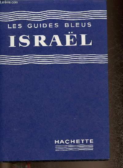
Finbert Elian J.
"Israël (Collection ""Les guides bleus"")"
Hachette. 1961. In-12. Relié. Bon état, Couv. convenable, Dos satisfaisant, Papier jauni. 454 pages. Quelques plans en noir et blanc et en couleur, hors texte. Jaquette en bon état. Deux signets légèrement abîmés.. Avec Jaquette. . . Classification Dewey : 912-Atlas, cartes et plans
Bookseller reference : RO30341899
|
|
|
FINLEY (M. I)
Atlas of Classical Archaelogy.
London, Chatto & Windus, 1977. In-4°, rel. éditeur pleine toile orange sous jaq. ill., 256pp., nbr. fig., cartes et ill. photographiques en noir et en bichromie. Table chronologique, index.
Bookseller reference : 504549 ISBN : 701121998
|
|
|
Findlay, Alexander G.
Classical Atlas to Illustrate Ancient Geography
"Comprised in twenty-six maps showing the various divisions of the world as known to the ancients composed from the most authentic sources with an index of the ancient and modern names." - from title page. Includes the following maps: Orbis Veteribus Notus; Roma; Italia Meridionalis; Athenae; Peloponnesus et Attica; Graecia Septentrionalis; Insuleae Maris Aeg Aei; Macedonia, Thracia, Illyria, Moesia, et Dacia; Britannia; Insuleae Britannicae; Gallia; Germania; Vindelicia, Noricum, Rhaetia, Pannonia, et Illyricum; Hispania; Africa Septentrionalis; Aegyptus; Asia Minor; Palaestina; Syria; Armenia, Mesopotamia, Assyria, et Babylonia; Arabia; Imperium Persicum; Indiae. Fold-out map entitled 'Central Italy with the Adjacent Countries from the Peutingerian Tables, constructed about A.D. 393'. Extensive 44-page index of place names. Hand done colour outlines to most maps. Average external wear. 1.5" opening to upper corner of front free endpaper. Toning to endpapers. Gilt titling clearly legible upon backstrip. Binding sound. A quality copy of this wonderful reference. Book

|
|
|
Fink, Klaus (Hrsg.)
Historischer Ortskernatlas der Stadt Kleve und ihrer Ortsteile. 1. Januar 1992. ERSTAUSGABE.
Kleve, Boss Verlag, 1992. 21 Seiten und zahlreiche Karten. Originalbroschur. im Originalschuber 31x41 cm
Bookseller reference : 303266

|
|
|
Finley, Moses I. [Mitarb.]
Atlas der klassischen Archäologie
München, List, 1979. 29 cm. 255 S. : zahlr. Ill., graph. Darst. u. Kt. Lw. Bibliotheksstemp. a. Vors.,sehr guter Zust.
Bookseller reference : 41153AB ISBN : 347177517
|
|
|
Fioruzzi (Lisi), Smiraglia (Claudio)
Mon atlas en couleurs.
français In-4 de 78 pp.; album cartonné illustré de l'éditeur. Riche illustration.
|
|
|
First Book Atlas Hammond Incorporated Incorporated
First Book Atlas Hammond
Good. unknown
Bookseller reference : 716417 ISBN : 0531004732 9780531004739
|
|
|
FISQUET (H.)
Grand ATLAS départemental de la France, de l'Algérie et des Colonies.
Paris, A. Le Vasseur, s.d. [1875]. 2 vol. in-folio à l'italienne (45 x 37cm), rel. éd. de l'époque demi-chagrin vert, dos à nerfs orné de caissons dorés, plats de percaline verte orné d'un grand décor doré (A. Souze) ; XXXIVpp.-106 cartes h.-t. colorées, accompagnées d'un texte explicatif rédigé au point de vue historique, physique, géographique, biographique, administratif, statistique, archéologique, descriptif et monumental (par H. Fisquet).
Bookseller reference : 593599
|
|
|
FISQUET H. JOANNE P.
LA DROME ,grand atlas departemental de la France Dictionnaire geographique et administratif de la France et de ses colonies
LES EDITIONS DU BASTION , REEDITIONS DE PLUSIEURS PLAQUETTES qui concernent la Drome publiées au XIX eme siecle , tirage numeroté , 1996
Bookseller reference : 3608
|
|
|
Fischer, H. R. (Hrsg.)
Keysers Taschenatlas der Seefahrt, Ein Nachschlagewerk für alle zur See Fahrenden und an die See Reisenden,
Heidelberg/München, Keysersche Verlagsbuchhandlung, 1959. 8°, 158 S., 16 Tafelseiten mit s/w-Abbildungen und 96 S. mit farbigen, z.T. sechsfarbigen Karten, blauer original Leineneinband (Hardcover) mit goldener Deckelverzierung und goldener Rückenbeschriftung sowie original Schutzumschlag, Seite 35/36 im Kartenteil an unterer Kante, mit kleinem Anriss und Knickspur, sonst schönes, sauberes Exemplar mit nahezu frischem Schutzumschlag
Bookseller reference : 16522CB
|
|
|
Fischer, H.-R. (Bearb)
Neuer Taschenatlas. Die Erde und ihre Länder in politischer und wirtschaftlicher Darstellung, mit 80 mehrfarbigen Kartenseiten und 15 000 Namen im Register.
Gütersloh, Die Garbe (um, 1964). Kl.8°-schmal. (15,8 cm x 8 cm). 156 Seiten. Originalkunststoffeinband. (Titel annähernd abgerieben. Einige Registerblätter lose). - Im übrigen sauber und vollständig.
Bookseller reference : 25809AB
|
|
|
Fischer, Hans-Richard, und Walter Christaller
Das Gesicht unserer Erde : Räume, Völker, Kontinente in Wort, Bild u. Karte ; e. Kompendium d. Geographie unserer Tage.
München : Südwest-Verl., 1961. 336 S. : mit 41 Abb., 88 S. Ktn, 32 S. 4°. OLwd mit Schwarzpräg. u. SU.
Bookseller reference : 11309
|
|
|
Fischer, Prof. H. und M. Geistbeck
Stufenatlas für höhere Lehranstalten.
Bielefeld, Verlag von Velhagen & Klasing, 1912. 54 S. 4° Quart, Halbleinen
Bookseller reference : 94791

|
|
|
Fite, Emerson D.. Freeman, Archibald. Editor
A Book of old Maps. Delineating American History from the Earliest Days Down to the Close of the Revolutionary War.
Cambridge., Havard University Press., 1926. Compiled and edited by Emerson D. Fite and Archibald Freeman. XV. Seiten Contents (Inhaltsverzeichnis, Einleitung), 74 Karten (schwarzweiß) mit Erläuterungen auf 299 Seiten. Eine farbige Weltkarte von 1538(?) vor dem Titel. Zustand: Ausgeschiedenes Bibliotheksexemplar, Einband- und Einbandkanten leicht berieben, unterer R'ücken mit Kleberesten eines entfernten Aufklebers, Vortitelblatt und Titelblatt mit Bibliotheksstempeln, 2°. OLeinen.
Bookseller reference : 042046
|
|
|
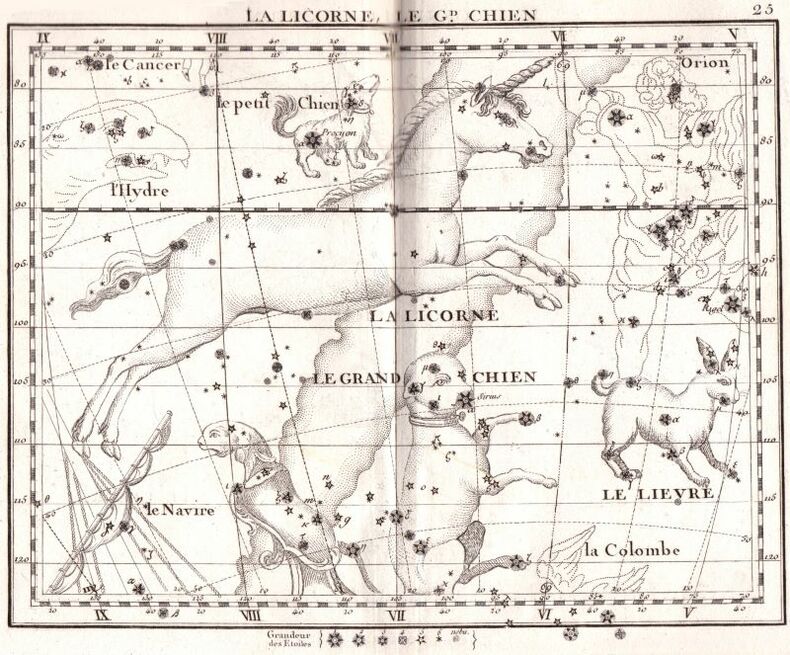
FLAMSTEED (John), FORTIN (J.).
Atlas céleste de Flamsteed, publié en 1776, par J. Fortin...
Paris chez le citoyen Lamarche 1795 1 vol. relié in-8 (225 x 150 mm), relié demi-basane havane, dos lisse, pièce de titre, IX + (1) + 47 pp. de texte et 30 belles planches à double page montées sur onglets (mors fendillés). Il s'agit de la troisième édition revue, corrigée et augmentée par les citoyens Lalande & Méchain. Ce superbe atlas de l'astronome britannique contemporain de Newton, premier atlas céleste fondé sur l'observation télescopique, avait d'abord paru à Londres en 1729 avec 28 planches in-folio, avant d'être repris en France en 1776, en 30 planches au format réduit d'un tiers par J. Fortin. La présente édition comporte de nombreux ajouts et corrections dans les positions des étoiles, détaillés dans le discours préliminaire. On trouve in-fine une mise à jour des positions des principales étoiles pour janvier 1800. Cartes astronomiques de première fraîcheur, sans rousseur. Rare et recherché.
Bookseller reference : 97929
|
|
|
Flatres, Pierre
Portrait de la France Moderne. atlas et géographie du Nord et de la Picardie. [Von Pierre Flatres].
Paris: Flammarion 1980. 423, (5) Seiten. Mit zahlreichen farbigen Abbildungen und Photographien im Text. 4° (26,5 x 19 cm). Orig.-Lederband mit Prägung auf Deckel und Rücken sowie marmorierten Spiegeln im illustrierten Orig.-Schutzumschlag. [Hardcover / fest gebunden].
Bookseller reference : 2067665

|
|
|
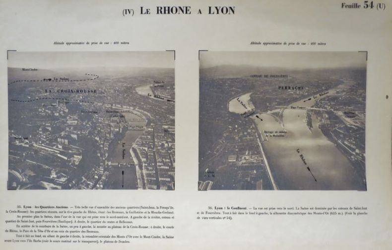
Fleury Seive, et André Cholley - [Université de Lyon. Commission des études Rhodaniennes].
Atlas Photographique Du Rhône. Par Fleury Seive, et André Cholley. Premier Fascicule, de la frontière suisse à lyon.
Lyon (Rhône), Desvigne, Editeur, 1931, 1 chemise à rabats de format oblong, contenant le premier fascicule in-folio 320x500 mm environ, 5euillets de texte dont 2 tableaux, pour l'assemblage des planches verticales et l'assemblage des planches panoramiques suivis de 54 planches avec suppléments soit 80 planches, impressions photographiques sépias en héliogravure sous serpentes légendées. La chemise est déchirée mais les planches sont en bon état.
Bookseller reference : 108263
|
|
|
Fleisher Michael; Atlas Comics
MORLOCK 2001; NO. 1 FEBRUARY 1975
New York City: Atlas Comics 1975. Not mint but near fine. Soft cover. Very Good to Fine/No Dust Jacket. 8vo - over 7�" - 9�" tall. Book. Atlas Comics Paperback
Bookseller reference : 66295
|
|
|
Flemming, M.. Merkel, G..Duncker, Alexander. Herausgeber / Bearbeiter
Grosser Atlas der Eisenbahnen von Mitteleuropa. I. Abtheilung: Deutschland und Schweiz. II. Abtheilung: Österreich-Ungarn und Serbien.
Braunschweig., Archiv Verlag. Reprint der Ausgabe: Verlag für Börsen- und Finanzliteratur AG. Leipzig 1903/4. Herausgegeben von Alexander Duncker, neu bearbeitet und vervollständigt von M. Fleming und G. Merkel. Textband. 2 Seiten - Zeichenerklärung und Verzeichnis der Karten;, I. Abteilung - Deutschland und Schweiz. (Stationsname, Bahn-Verwaltung, Karte) 43 Seiten.; II. Abteilung - Österreich-Ungarn und Serbien (Stationsname, Bahn-Verwaltung, Karte) 22 Seiten.; Auszug aus den allgemeinen Tarifvorschriften nebst Güterklassifikation, Kilometer-Zeiger und Kilometer-Tariftabelle. 44 Seiten.; Verzeichnis von Verkehrs-Orten (nicht Eisenbahn-Stationen) des Deutschen Reiches mit angabe der nächstgelegenen Post- und Eisenbahnstation. 111 Seiten.; Anhaag ... - Verzeichnis der Spediteure des Deutschen Reiches. XV Seiten;;; Kartenkassette, ein Doppelblatt Verzeichnis der Karten nach Ländern. 2 Übersichtskarten, 37 gefaltete Karten. ; Guter Zustand. 4°. H OLeinen / OLeinen-Kassette.
Bookseller reference : 062610
|
|
|
FLORE SUISSE par Edouard THOMMEN.
Atlas de poche de la flore suisse comprenant les régions limitrophes. Plus de 3000 dessins au trait ...
Ed. Birkhaeuser 1951. Bon exemplaire relié, jaquette conservée, pet. in-8 obhaut, XIV + 296 pages avec index.
Bookseller reference : AUB-8557
|
|
|
Flèche, l'Abbé
Petite géographie méthodique de la france en vers artificielscomprenant les 86 départements sur 86 rimes différentes.
français In-12 de 60 pp.; cartonné de l'éditeur.
|
|
|
FLÜCK & SCHLUMPF & SIEGFRIED (Hrsg.):
Pharmakognostischer Atlas zur Pharmacopoea Helvetica. 5. Aufl.
Zürich, Fretz, 1935, gr. in-8vo, 446 S., reich ill., Original-Leinenband.
Bookseller reference : 63428aaf
|
|
|
FOLDEX
Carte de l'Extrême-Orient
CHEZ L'AUTEUR. Non daté. In-Plano. En feuillets. Etat d'usage, Couv. convenable, Dos satisfaisant, Intérieur frais. Carte dépliante de 65/55 cm, hors-texte. Pas de plats de couverture.. . . . Classification Dewey : 912-Atlas, cartes et plans
Bookseller reference : RO80014963
|
|
|
Foltz Frédéric
Halenza's Neuestes Rhein-Panorama von Mainz bis Cöln - Le Rhin de Mayenne jusqu'à Cologne
Joseph Halenza. Non daté. In-8. Cartonné. Etat d'usage, Couv. partiel. décollorée, Dos abîmé, Intérieur frais. Panorama en noir et blanc plié en acordéon de 15 volets. Le Rhin de Mayenne jusqu'à Cologne, dessiné d'une manière pittoresque et topographique et gravé sur acier par Frédéric Foltz. Panorama de toute la longueur du Rhin de Mayenne à Cologne, avec en marge des illustrations de points de repère (monuments ou paysages). Non daté. Coins légèrement frottés. Dos du cartonnage abîmé, mors fendus, léger manque en coiffe de pied.. . . A l'italienne. Classification Dewey : 912-Atlas, cartes et plans
Bookseller reference : R300270730
|
|
 Receive by email
 Download as PDF document
 RSS feed


