|
|
|
PORTINARO PIERLUIGI E BIANCHI ANNA.
ALESSANDRIA NELLE ANTICHE STAMPE. CARTE GEOGRAFICHE, TOPOGRAFICHE, PIANTE, VEDUTE, COSTUMI.
VERCELLI GIORGIO TACCHINI 1984. (mm. 292 x 225). Tela editoriale con sovraccoperta. pp. 223(1). Disegni nel testo.
|
|
|
PORTINARO PIERLUIGI.
La provincia di Biella nelle antiche stampe. Carte geografiche, topografiche, piante, vedute, costumi.
in 4°, cart. edit. con sovracc. edit. ill., pp. (2),224, con piantine ed ill. n.t., ottimo es.

|
|
|
PORTINARO, Pierluigi; Franco Knirsch
The Cartography of North America, 1500 - 1800
royal 4to [33 x 25 cm]; 320 pp, 121 plates, nearly all in color and including many double-page, mostly reproducing old maps, many other illus, biographical notes, index. original cloth, dj, fine in fine dj. A picture of this book is available upon request by email. A quality production with numerous excellent illustrations, and with useful text on the history of cartography, the history of New World exploration and mapmaking techniques.
|
|
|
Porzione cartografica dell'Italia ..
Sardegna, Sicilia e punta delle calabria.
Carta geografica di cm. 73x53, raffigurazioni geografiche con porzioni a colori su fondo bianco. Tavola 3° scala di 1 a 1000000. Legenda con segni convenzionali. Segni di piegatura.

|
|
|
Potter, Jonathan
Collecting Antique Maps: An Introduction to the History of Cartography
Folio 207p., illus. Hardcover Very good condition good
|
|
|
POULIT Jean, sous la direction de.
TROIS SIÈCLES DE CARTOGRAPHIE EN ÎLE-DE-FRANCE, volume 1.
Les cahiers de l'Institut d'aménagement et d'urbanisme de la région Île-de-France, n° 119, Paris, décembre 1997. In-4, broché, feuillet d'errata, illustrations.
Referenz des Buchhändlers : 7135
|
|
|
Pouqueville, François Charles Hugues Laurent
Le Grecia di M. Pouqueville tradotta da A. Francesco Falconetti con note ed illustrazioni
8°, 23 cm, pp. 475, una carta geografica ripiegata e 116 tavole incise fuori testo su 120, mancano 4 incisioni, rilegatura coeva in mezza pelle, titolo in oro su tassello al dorso, piatti marmorizzati. Fa parte di: L'Universo o storia e descrizione di tutti i popoli ec. Strappo a una carta lontano dall'incisione, esemplare nell'assieme molto buono

|
|
|
Pozzi,Alfeo.
La terra. Manuale di geografia. per i Licei, gl'Istituti Tecni
<br/> STATO: DA COLLEZIONE, MOLTO BUONO.<br/> NOTE: Lievi abrasioni alla pelle del dorso.<br/> TITOLO: La terra. Manuale di geografia. per i Licei, gl'Istituti Tecnici, i Collegi Militari, le Scuole Magistrali e Commerciali.<br/> AUTORE: Pozzi,Alfeo.<br/> CURATORE: IV ediz.rifatta da Gottardo Garollo.<br/> EDITORE: Libr.Editrice Agnelli<br/> DATA ED.: 1886,<br/>
|
|
|
Praesent, H
Bibliographische Übersicht d. deutschen Schulwandkarten.
Stuttgart, Fleischhauer & Spohn, 1928. X, 120 S. Hlwd. St. a. Tit. (Unterrichtsbeitr. z. Pflege d. Geogr. u. geogr. Landeskde. B 5/6).
Referenz des Buchhändlers : 608481
|
|
|
PRATOLONGO Giuseppe -
Matteo Ricci: pioniere della cartografia.
Firenze, 1956, 8vo stralcio con copertina posticcia muta, pp. 267/270. - !! ATTENZIONE !!: Con il termine estratto (o stralcio) intendiamo riferirci ad un fascicolo contenente un articolo, completo in se, sia che esso sia stato stampato a parte utilizzando la stessa composizione sia che provenga direttamente da una rivista. Le pagine sono indicate come "da/a", ad esempio: 229/231 significa che il testo è composto da tre pagine. Quando la rivista di provenienza non viene indicata é perché ci è sconosciuta. - !! ATTENTION !!: : NOT A BOOK : “extract” or “excerpt” means simply a few pages, original nonetheless, printed in a magazine. Pages are indicated as in "from” “to", for example: 229/231 means the text comprises three pages (229, 230 and 231). If the magazine that contained the pages is not mentioned, it is because it is unknown to us.

|
|
|
Preobrazenskij, A.I
Ökonomische Kartographie. Dt. v. Kollektiv Gringmuth.
Gotha, Haack, 1956. M. 30 Taf. im Anhang u. zahlr. Abb. 228 S. OHlwd.
Referenz des Buchhändlers : 244240
|
|
|
Prep. by AZADE HUSEYNOVA, NAIDE ABBASOVA, EMINE MELIKOVA.
The Nobels and Baku oil: Dedicated to 130th anniversary of Nobel Brothers' activity in Azerbaijan, 1879-2009.= Nobeller ve Bakü petrolü: Nobel Kardeslerin Azerbaycan'daki faaliyetlerinin 130. yilina ithaf olunmustur.
Fine English Original bdg. Dust wrapper. In special box. Folio. (31 x 23 cm). In English and Turkish. 188 p., richly b/w and color ills. In collaboration with the Ministry of Culture and Tourism of the Republic of Azerbaijan, Dd created an exhibition "The Nobels and Baku Oil" that was displayed at the Baku Museum Centre. The exhibition was dedicated to the 15th anniversary of the Contract of the Century and the 130 years since the Nobel Brothers opened their business in Baku. It told the story of the Nobel Company's accomplishments in Azerbaijan from 1874 to 1920 and its role in the economic, technological and social development of the region. The Nobel brothers - Alfred, Ludvig and Robert - once had with Baku. In fact, when the Nobel Prizes were established more than a century ago (1901), roughly 12 percent of the prize money was drawn from Alfred's shares in the Nobel Brothers' Petroleum Company in Baku. The Petroleum Production Company Nobel Brothers, Limited, or Branobel ("Nobel Brothers" in Russian), was an oil company set up by Ludvig Nobel and Baron Peter von Bilderling. It operated mainly in Baku, Azerbaijan, but also in Cheleken, Turkmenistan. Originally established by Robert Nobel (who contributed 25,000 rubles) and the investments of barons Peter von Bilderling (300,000 rubles) and Standertskjöld (150,000 rubles) as a distillery in 1876, it became, during the late-19th century, one of the largest oil-companies in the world. The Nobel Brothers Petroleum Company was an oil-producing company that had its origins in a distillery, founded by Robert and Ludvig Nobel in Baku in 1876, which, in 1879, turned into a shareholding company headquartered in St. Petersburg. The share capital of three million rubles was divided as follows: 53,7% Ludwig Nobel, 31,0% Baron Peter von Bilderling, 4,7% I.J. Zabelskiv, 3,8% Alfred Nobel, 3,3% Robert Nobel, 1,7% au Baron Alexandre von Bilderling. Pipeline transport was pioneered near Baku by Vladimir Shukhov and the Branobel company in 1878-1880. On 10 April 1902, the company signed a contract for the purchase of oil fields in Romany, which were owned by the oil producer Isabey Hajinsky. On 17 October 1905, in accordance with the Committee of Ministers, the company purchased the oil fields owned by oil producer A. Adamov. The company's fixed capital in 1914-1917 was 30 million rubles. By 1916, it was the largest oil company in Russia, producing 76 million poods of oil. Between 1877 and 1901, the company drilled over 500 wells, produced 150 million barrels of oil, and employed 12,000 workers.
|
|
|
Prep. by E. NARDIN.
[MAP] A IV. Sinob. Black Sea shores, Pontus Euxinus.
Very Good French Original color map on cloth. Folded. Oblong atlas folio. (48 x 63 cm). Toponyms in German. It shows Sinop and Samsun city with their shores to 'Schwarzes Meer' and their hinterlands. [MAP] A IV. Sinob. Black Sea shores, Pontus Euxinus.
|
|
|
Prep. by IRFAN DAGDELEN.
Istanbul Büyüksehir Belediyesi Atatürk Kitapligi harita-haritalar katalogu. 4 volumes set.
Fine Turkish Paperback. 4to. (29 x 21 cm). In turkish. 4 volumes set: ([xiv], 333 p.; [4], [iv], 212 p.; [8], 200 p.; [8], 197 p.; 12 color plates, b/w ills.). Istanbul Büyüksehir Belediyesi Atatürk Kitapligi harita-haritalar katalogu. 4 volumes set. A very comprehensive map catalogue from Istanbul Municipality Ataturk Library Collection.
|
|
|
Prep. by MURAT P. ERKEN.
Savaslarda haritacilar.
New Turkish Paperback. Demy 8vo. (21 x 14 cm). In Turkish. 158 p., b/w ills. Savaslarda haritacilar. A list and biographies of military cartographers of the Ottoman Empire and Turkish Republic from Mehmed Sevki to Mehmet Neset. It includes 150 short biographies with battles their participated. A fine reference for Turkish cartography.
|
|
|
Prep. by SÜKRÜ AKALIN et all.
Chart and map catalogue of Turkish Naval Museum.= Türk Deniz Müzesi harita katalogu.
Fine Fine English Original bdg. Dust wrapper. Oblong 4to. (28 x 28 cm). In English and Turkish. 437 p. Color ills. 1000 copies were printed. Chart and map catalogue of Turkish Naval Museum.= Türk Deniz Müzesi harita katalogu.
|
|
|
Prep. by ZEKERIYA KURSUN.
A handbook of the Ottoman Palestine place names and atlas, 1516-1917.= Osmanli Filistini yer isimleri kilavuzu ve atlasi, 1516-1917. Edited by Esra Karadag.
New English Original bdg. HC. Folio. (32 x 24 cm). In English, Turkish, and Arabic. 240 p., richly ills., and folded Palestine maps on the end-pocket. A handbook of the Ottoman Palestine place names and atlas, 1516-1917.= Osmanli Filistini yer isimleri kilavuzu ve atlasi, 1516-1917. Edited by Esra Karadag.
|
|
|
Presciuttini Paola
Coste del Mediterraneo nella cartografia Europea 1500 1900
Cm. 32.5x34.5 (oblungo), pp. 180 completamente illustrate a colori, legato in piena tela con sovraccoperta illustrata, bel cofanetto in tela e cartone forte illustrato. Nuovo. Non comune.
|
|
|
PRESCIUTTINI Paola -
Coste del mondo nella cartografia europea. 1500-1900.
Ivrea, Priuli & Verlucca, 2000, 4to album tutta tela editoriale con sovraccopertina illustrata a colori, cofanetto editoriale in cartoncino rigido illustrato a colori, pp. 179 completamente illustrato da belle riproduzioni in nero e a colori. In stato di nuovo,n l'originale scatola in cartone. Unito libretto in-8vo brossura, di pp. 64 con la traduzione del testo in lingua inglese. Collana antica cartografia

|
|
|
Press, Jesaias / Lilien, E. M. [Ephraim Moses] [Illustr.]
Palästina und Südsyrien Reisehandbuch. Im Auftrage der Palestine Express Comp. verfasst von Jesaias Press. Mit vier Bildern von E. M. Lilien, 3 Karten, 5 Plänen und 2 Grundrissen.
Contains maps and illustrations. 170x120 mm. VIII+367 pages. Hardcover. Cover yellowing, worn and slightly stained. Cover corners and edges bumped and tattered. Spine yellowing and worn. Spine edges bumped. Inner cover and some pages age-stained - no damage to text. Stamp on few pages - no damage to text. Binding visible between several pages. Few pages slightly wrinkled. Pages yellowing. In good reading condition.
|
|
|
PREVOT Eugène
"Topographie (instuments), suivi d'un appendice relatif à la topographie expédiée (par O. Roux); Livre 1er : Instruments, description, manuvre, vérification, réglage et précision. Bibliothèque de l'ingénieur de Travaux Publics."
Paris, Dunod, 1925. 12 x 19, 542 pp., 343 figures, 1 planche dépliante, reliure d'édition pleine toile rouge, bon état (couverture insolé, cachet d'ex-prioritaire).
Referenz des Buchhändlers : 90919
|
|
|
PRICE (Henry)
An Alphabetical List of the Names of the Hundreds, Parishes, Chapelries, Villages, Gentlemens' Seats, Farm Houses, And other Places in the New Map of Herefordshire, Lately Published by Henry Price.
First and only edition, [2], vi, 37,[1] + 2pp., of adverts, orig. printed blue boards with white paper spine, the spine is worn with some loss to the original cover at base, some brown damp staining to lower inner margins which correspond with the damage to base of spine, partly unopened, uncut. A good acceptable example of this very rare work which was bought out to accompany Henry Price's New Map of the County of Hereford which is advertised at the rear of the book. Copac listing a single copy at Cardiff University Libraries.
|
|
|
Price, Roberto Salinas (compiled by)
ATLAS OF HOMERIC GEOGRAPHY
Very minor shelfwear and rubbing to boards. ; 60 pages
|
|
|
PRINCIPE Ilario -
La cartografia ufficiale nelle regioni italiane: Calabria.
Firenze, 1992, 8vo stralcio con copertina posticcia muta, pp. 146/167 con 8 carte in nero e 3 a colori. - !! ATTENZIONE !!: Con il termine estratto (o stralcio) intendiamo riferirci ad un fascicolo contenente un articolo, completo in se, sia che esso sia stato stampato a parte utilizzando la stessa composizione sia che provenga direttamente da una rivista. Le pagine sono indicate come "da/a", ad esempio: 229/231 significa che il testo è composto da tre pagine. Quando la rivista di provenienza non viene indicata é perché ci è sconosciuta. - !! ATTENTION !!: : NOT A BOOK : “extract” or “excerpt” means simply a few pages, original nonetheless, printed in a magazine. Pages are indicated as in "from” “to", for example: 229/231 means the text comprises three pages (229, 230 and 231). If the magazine that contained the pages is not mentioned, it is because it is unknown to us.

|
|
|
Prioli, Angelo; Bini, Silvestro; Borgogno G.
Breve geografia d'Italia preceduta da alcuni cenni sulla terra e le sue parti principali accompagnata da quattro tavole con figure geografiche. Legato a: Lezioni elementari di Geografia dettate dal prof. Silvestro Bini. Legato a: Nozioni di aritmetica di geometria e di sistema metrico decimale coll'agginta di unappendice sulle frazioni. Legato a: Nozioni di grammatica italiana proposte alle classi elementari superiori
4 volumi, 18 cm, pp. 96; 80; 88; 96, il primo volume ha 4 tavole più volte ripiegate. Rilegatura coeva in mezza pelle, titolo in oro al dorso, piatti marmorizzati, tagli spruzzati, esemplare molto buono e fresco

|
|
|
Progetto editoriale MARISA LAVERONI
PER LE ANTICHE CONTRADE - CARTE GEOGRAFICHE DELLA PADANIA
Cartelletta in -8 (22 x 30,5 cm.), legatura editoriale cartonata bianca con illustr. a colori sul piatto anteriore, all'interno: a) volume in brossura illustr. a colori con 80 pag. e molte illustr. in b.n. nel testo e a p.pagina - b) cartelletta sempre illustr. a colori contenente 5 riproduzioni di carte geografiche in grandezza naturale a colori (dim./cad. ripiegate L. 82 x H. 59 cm. e L. 59 x H. 41cm.). In buone condizioni. ---

|
|
|
PRONK, P. - H.M. VAN RANDWIJK, & G.F. WILLEMS
Nederlandse Wereldatlas. De wereld in kaart, woord en beeld.
Amsterdam, DE BRUG, 1959 Faux-lederen band met stofwikkel, 292 pagina's, 31 x 22 cm, NL. *mooie staat, stofwikkel heeft slijtage.
Referenz des Buchhändlers : 68674
|
|
|
Prontera, Francesco (a Cura di)
Vie e Luoghi dell'Etruria Nella Tabula Peutingeriana
Mm 355x300 Volume cartonato, legatura editoriale in tela oliva, velina protettiva in acetato trasparente, 63 pagine, numerose illustrazioni in bianco e nero e una cartina a colori più volte ripiegata in chiusura, che è la riproduzione, ingrandita e a colori, del fac-simile della Tabula Peutingeriana pubblicato nel 1916 da K. Miller. Libro in condizioni di nuovo. SPEDIZIONE IN 24 ORE DALLA CONFERMA DELL'ORDINE.
|
|
|
Prontera, Francesco.
Geografia e storia nella Grecia antica.
Gli studi di Prontera si rivolgono a figure di primo piano della cultura greca (Erodoto, Eratostene, Polibio e Strabone) che hanno segnato la formazione e trasmissione del sapere geografico. Emerge così in età tardo-ellenistica il relativo progresso della cartografia antica, che riguarda non solo il profilo del Mediterraneo o dell’Asia-continente, ma anche gli spazi ‘regionali’ che caratterizzano <br/> TITOLO: Geografia e storia nella Grecia antica. <br/> AUTORE: Prontera, Francesco.<br/> EDITORE: Olschki Ed.<br/> DATA ED.: 2011,<br/> COLLANA: Biblioteca di «Geographia Antiqua», 4.<br/> EAN: 9788822260857

|
|
|
Prosperi Franco
Gran Comora [ISOLE COMORE]
17 foto a colori, 39 in bianco e nero, 1 cartina

|
|
|
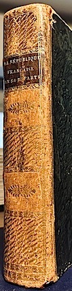
PRUDHOMME (Louis);
La RÉPUBLIQUE FRANÇAISE en LXXXIV départemens; Dictionnaire géographique et méthodique destiné aux administrateurs, négocians, gens d'affaire et à ceux qui étudient la géographie de la France.
Editeur [Prudhomme] Paris 1793 1 vol. In-8 de VI 1 f.n.ch. (table) 366 pp. 1 f.n.ch. (avis), demi-veau de l'époque, dos lisse orné, pièce de titre (accroc à la coiffe inférieure, coins émoussés).
Referenz des Buchhändlers : 15768
|
|
|
Prunetti, Michelangelo.
L'osservatore delle Belle arti in Roma ossia Esame analitico de' monumenti antichi, e moderni spettanti alla pittura, scultura, e architettura tuttora esistenti nelle chiese, gallerie, ville ed altri luoghi dell'alma città di Roma.
12°, mm 180x100, due volumi di pp. VIII, 327, (1); VIII, 336. Brossure coeve, sciupate, con mancanze ai dorsi e disegni in inchiostro ai piatti del secondo tomo. Interno in barbe e ben conservato. Il nome dell'autore è tratto dalla carta di dedica. Edizione originale e unica.

|
|
|
Przybyllok, E
Über d. sogenannte Polflut in d. Ost- u. Nordsee.
Berlin, 1919. 4°. M. 1 Taf. 24 S. OBr. Umschl. leicht gebräunt u. etwas eingerissen. (Veröffentlichung d. Königl. Preuszischen Geodätischen Institutes. N.F. 80)
Referenz des Buchhändlers : 159747
|
|
|
PTOLEMAEI Claudii ( PTOLÉMÉE )
COSMOGRAPHIA. Tabulae
Paris Editions Hier et Demain 1976 grand in folio (46,5x35) 1 volume sous boitage de l'éditeur, dos et plat supérieur titrés, renfermant un fascicule de texte de 24 pages [1], suivi de 27 planches doubles hors-texte en couleurs de cartes. Collection cartographie antique. Collationné complet. Tirage limité à 999 exemplaires numérotés. Bel exemplaire ( Photographies sur demande / We can send pictures of this book on simple request ) poids du colis: 3 kilogrammes, emballage de protection
Referenz des Buchhändlers : 053104
|
|
|
Ptolemaeus, Claudius
Cosmographia. Weltkarten. Einleitung und Anmerkungen von Lelio Pagani.
Würzburg, Popp, 1977. Folio. 46 cm. [12] Seiten, XXVII Blatt. Original-Leinenmappe.
Referenz des Buchhändlers : 51710BB

|
|
|
Ptolemaeus, Claudius
Die Cosmographia des Claudius Ptolemäus. Codex Urbinas Latinus 277. 2 Bände [Faksimileausgabe mit Einführungsband].
Zürich, Belser Verlag, 1983. Faksimileband: 62 x 46 cm. Kassette: 87 x 51 cm. 135, [2] Blatt; 80 Seiten. Original-Ganzlederband mit reicher Blind- und Goldprägung, 10 Messingbeschlägen und Lederriemenschließen mit Messingverschlüssen und Original-Pappband mit goldgeprägtem Titel in Original-Schmuckkassette aus Holz, die als Lesepult zusammengesetzt werden kann. [7 Warenabbildungen] (Codices e Vaticanis selecti, LIII).
Referenz des Buchhändlers : 3032FB

|
|
|
Ptolemaeus, Claudius
Die Cosmographia des Claudius Ptolemäus. Codex Urbinas Latinus 277. [Faksimileband apart].
Zürich, Belser Verlag, 1983. Faksimileband: 62 x 46 cm. Kassette: 87 x 51 cm. 135, [2] Blatt; 80 Seiten. Original-Ganzlederband mit reicher Blind- und Goldprägung, 10 Messingbeschlägen und Lederriemenschließen mit Messingverschlüssen und Original-Pappband mit goldgeprägtem Titel in Original-Schmuckkassette aus Holz, die als Lesepult zusammengesetzt werden kann. [8 Warenabbildungen] (Codices e Vaticanis selecti, LIII).
Referenz des Buchhändlers : 4043FB

|
|
|
PTOLÉMÉE (Claude)
Claudii Ptomlomaei. Cosmographia Tabulae…
Torriana, Paris, Booking International, 1990. In folio (270 x 380) de XVI p. et 27 planches en double page. Cartonnage glacé bleu de l’éditeur, illustration en couleurs sur le plat sup. Etat neuf.
Referenz des Buchhändlers : EYL-64
|
|
|
PUAUD, Guy
Les noms de terroirs ou la mémoire des lieux.
Maulévrier, éd. Hérault, 6 janvier 1992, in-8, cartonnage souple, couv. ill. en noir éd., 322 pp., nb. plans et cartes en noir, la toponymie de Saint-Sauvant, bibliographie, index, table des illustrations, table des matières, D’où viennent-ils les noms de terroirs, tous ces noms de villages, de fermes, de champs, de bois, de chemins ? Quelles significations, que disent-ils ? Une très Grande étude, une référence ! RARE Très bon état
Referenz des Buchhändlers : 70365
|
|
|
PUISSANT (Louis)
Traite de G?od?sie, ou Exposition des M?thodes Trigonom?triques et Astronomiques, Applicables a la mesure de la terre, et a la construction du canevas des cartes topographiques.
Third edition, 4to, 2 vols., in one, xvi, 515, [1]pp., 11 engraved folding plates; xi, [1], 496, xxxii + 24pp., of publishers adverts, 3 engraved plates (first with slight chipping to blank foremargin, cont. calf, lacks spine.
|
|
|
Puissant Louis.
Traité de topographie, d'arpentage et de nivellement [..]. [UNITO A]: Supplement au second livre du traité de topographie, contenant la théorie des projections des cartes. [UNITO A]: Mémoire sur la projection de Cassini pour servir de supplément a sa théorie des projection des cartes géographiques.
2 volumi in uno in-4º (cm. 25,2), legatura in m. pelle (piccoli strappi al dorso); pp. XX, 331, [19] di tabelle e 6 tavole ripiegate f.t.; pp. 112 e 2 tavole ripiegate f.t.; pp 43, [1] in ottimo stato. Prima edizione di quest'opera (1807) e dei suoi supplementi (1810-1812), testi base per gli Ingenieurs-Geographes del Depot general de la guerre, e per le scuole di applicazione del periodo napoleonico. Louis Puissant (1769-1843) pose qui le basi della moderna cartografia scientifica e delle misurazioni astronomiche. Dedicata al principe Alessandro, l'opera espone nella prima parte le teorie fondamentali delle grandi operazioni geodetiche, e nella seconda parte le applicazioni sul terreno e le operazioni grafiche che conducono alla formazione delle carte topografiche. Il Puissant soggiorno' anche in Italia, prima per il tracciamento della posizione geografica e della cartografia dell'Isola d'Elba, e poi, a Milano, per la nuova carta d'Italia. Cfr. NBG XLI, 188-189. Buon esemplare. (SE3)
|
|
|
PULCINI TANIA TOMASSINI GABRIELLA ( A CURA DI )
INCANTI DELL'OCCHIO E DELL'ORECCHIO. TERNI ED IL SUO TERRITORIO: INCISIONI DAL XVII AL XIX SECOLO.
IN 8° CARRE ( cm.22,5 X 26 ). pp.99. COPERTINA EDITORIALE PATINATA ILLUSTRATA CON TITOLO E RISVOLTI. VOLUME RICCAMENTE ILLUSTRATO in b/n. CON RIPRODUZIONE DI CARTE E VEDUTE DEL TERNANO. CATALOGO DELLA MOSTRA TENUTASI A TERNI, CENACOLO S.MARCO DAL 2 AL 16 DICEMBRE,1992. PREFAZIONE DI ATTILIO BRILLI. PRESENTAZIONE DI PAOLA MARALDI. LE TECNICHE DI INCISIONE DI MONICA MORICI. LA CITTA, PIANTE E VEDUTE DI TANIA PULCINI - MINISTERO PER I BENI CULTURALI E AMBIENTALI, ARCHIVIO DI STATO DI TERNI, COMUNE DI TERNI - BIBLIOTECA COMUNALE. " PASSAGGI " - RIVISTA DELL'I.S.T.E.S. <BR>STATO NUOVO. ID 7033

|
|
|
Pumain Denise Béguin Michèle Mathian Hélène Finance Olivier Collectif
La représentation des données géographiques - 4e éd. - Statistique et cartographie: Statistique et cartographie
ARMAND COLIN 2017 264 pages 14 8x20 8x1 8cm. 2017. Broché. 264 pages. Ce manuel présente les principaux outils et méthodes pour réaliser tous types de cartes et graphiques en géographie. Il expose de manière claire avec de nombreux exemples les règles fondamentales du traitement des données du langage graphique et les logiques d'utilisation des outils statistiques et cartographiques de base. L'ouvrage répond au besoin croissant de production cartographique dans un contexte de multiplication des bases de données et d'usage informatique
Referenz des Buchhändlers : 500347840

|
|
|
PUPPI G. - ZANOTTI A. L. - SPERANZA M. -
Lo studio dei bioritmi nel territorio: cartografia fenologica e sue applicazioni.
Firenze, Società Botanica Italiana, 1990, 8vo punto metallico, pp. 688/697 con un grafico e 4 carte.

|
|
|
PUPPI Giovanna - ZANOTTI Anna Letizia - SPERANZA Maria -
Cartografia fenologica automatica nella collina bolognese.
Forlì, “Archivio Botanico e Biogeografico Italiano”, 1985, 8vo punto metallico, pp. 29/43 con 2 grafici, 2 tabelle e 2 carte a colori, di grande formato, più volte ripiegate, allegate in fine.

|
|
|
PUPPI LIONELLI (a cura di)
Ritratto di Verona.
In 4° (310x210); pagg. XXXI, 652 con una grande tavola ripiegata fuori testo raffigurante una veduta di Verona di Marco Moro, XV illustrazioni a col. , XXI in nero, 341 in nero di stampe e piante della città, particolari architettonici, monumenti ecc.Interessante bibliografia sulle vedute, piante e carte geogr. di Verona con dettagliate schede Contiene saggi di Marchi, Lorenzoni, Brugnoli, Marchini, Concina, mazzi, Borelli ed altri. Tela editoriale con sovracoperta a colori e custodia. Contiene interessanti saggi di storia veneta, architettura, istituzioni civili e sociali. Come nuovo.
|
|
|
Putmam Robert
OUDE SCHEEPSKAARTEN en un makers HOOGTEPUNTEN uit vijfeeuwen cartografie.
Ril. in tela con sovr., cm 39x3o,5, pp 143, moltissime splendide tavv. a col.. - ISBN: 9061133092

|
|
|
Putman, Robert.
Oude scheepskaarten en hun makers: hoogtepunten uit vijf eeuwen cartografie.
Gebonden, blauw linnen, vergulde titel op de rug, originele geillustreerde omslagwikkel in kleur, 38,5x31cm, 143pp, rijkelijk en fraai geillustreerd in kleur en z/w. De in dit boek afgebeelde scheepskaarten, daterend van begin van de veertiende eeuw tot in de achtiende eeuw, vormen tezamen een overzicht van de verovering van de onbekende kusten der aarde. Verlucht met 67 grote afbeeldingen en vele details.

|
|
|
Putman, Robert.
Oude scheepskaarten en hun makers: hoogtepunten uit vijf eeuwen cartografie.
, Amsterdam, Becht, 1983., Gebonden, blauw linnen, vergulde titel op de rug, originele geillustreerde omslagwikkel in kleur, 38,5x31cm, 143pp, rijkelijk en fraai geillustreerd in kleur en z/w.
Referenz des Buchhändlers : 14184
|
|
|
PÉRIGOT, Ch. BARBERET Charles
Atlas physique et Politique de la France pour servir à L'Étude de la Géographie et de L'Histoire de France (---) Paris, Dezobry, E. Magdeleine et Cie. 1857.
1 vol. in-4° rel. demi-toile bleue, plats de papier illustré (usage avec nombreuses taches et petits manques), 6 p. la carte N°25 France Politique Actuelle n'est pas présente. 24 cartes coloriées. Quelques petites taches en marge sans gravité. Très bon état interne. Extérieur usagé.
Referenz des Buchhändlers : 14352

|
|
|

 Per e-mail erhalten
 Als pdf-Dokument herunterladen
 RSS feed
 Permanenter link


