|
Robert Franc?ois Masson de Morvilliers Nicolas approximately Bonne Rigobert. Atlas encyclope?dique
Geographie moderne Volume v.88 1788 Leather Bound
2019. Leather Bound. New. Leather Binding on Spine and Corners with Golden Leaf Printing on round Spine. Reprinted in 2019 with the help of original edition published long back 1788. This book is printed in black & white sewing binding for longer life Printed on high quality Paper re-sized as per Current standards professionally processed without changing its contents. As these are old books we processed each page manually and make them readable but in some cases some pages which are blur or missing or black spots. We expect that you will understand our compulsion in these books. We found this book important for the readers who want to know more about our old treasure so we brought it back to the shelves. Hope you will like it and give your comments and suggestions. Lang: - fre Vol: - Volume v.88 Pages 800. EXTRA 10 DAYS APART FROM THE NORMAL SHIPPING PERIOD WILL BE REQUIRED FOR LEATHER BOUND BOOKS. FOLIO EDITION IS ALSO AVAILABLE. Volume v.88 hardcover
Bookseller reference : LB1111008439266
|
|
|
Robert Franc?ois Masson de Morvilliers Nicolas approximately Bonne Rigobert. Atlas encyclope?dique
Geographie moderne Volume v.89 1788 Leather Bound
2019. Leather Bound. New. Leather Binding on Spine and Corners with Golden Leaf Printing on round Spine. Reprinted in 2019 with the help of original edition published long back 1788. This book is printed in black & white sewing binding for longer life Printed on high quality Paper re-sized as per Current standards professionally processed without changing its contents. As these are old books we processed each page manually and make them readable but in some cases some pages which are blur or missing or black spots. We expect that you will understand our compulsion in these books. We found this book important for the readers who want to know more about our old treasure so we brought it back to the shelves. Hope you will like it and give your comments and suggestions. Lang: - fre Vol: - Volume v.89 Pages 834. EXTRA 10 DAYS APART FROM THE NORMAL SHIPPING PERIOD WILL BE REQUIRED FOR LEATHER BOUND BOOKS. FOLIO EDITION IS ALSO AVAILABLE. Volume v.89 hardcover
Bookseller reference : LB1111008439267
|
|
|
Robert Franc?ois Masson de Morvilliers Nicolas approximately Bonne Rigobert. Atlas encyclope?dique
Geographie moderne Volume v.90 1788 Hardcover
2020. Hardcover. New. Lang: - fre Vol: - Volume v.90 Pages 774. Reprinted in 2020 with the help of original edition published long back 1788. This book is printed in black & white Hardcover sewing binding for longer life with Matt laminated multi-Colour Dust Cover Printed on high quality Paper re-sized as per Current standards professionally processed without changing its contents. As these are old books we processed each page manually and make them readable but in some cases some pages which are blur or missing or black spots. We expect that you will understand our compulsion in these books. We found this book important for the readers who want to know more about our old treasure so we brought it back to the shelves. Any type of Customisation is possible with extra charges. Hope you will like it and give your comments and suggestions. Volume v.90 hardcover
Bookseller reference : 1111008439265
|
|
|
Robert Franc?ois Masson de Morvilliers Nicolas approximately Bonne Rigobert. Atlas encyclope?dique
Geographie moderne Volume v.89 1788 Hardcover
2020. Hardcover. New. Lang: - fre Vol: - Volume v.89 Pages 834. Reprinted in 2020 with the help of original edition published long back 1788. This book is printed in black & white Hardcover sewing binding for longer life with Matt laminated multi-Colour Dust Cover Printed on high quality Paper re-sized as per Current standards professionally processed without changing its contents. As these are old books we processed each page manually and make them readable but in some cases some pages which are blur or missing or black spots. We expect that you will understand our compulsion in these books. We found this book important for the readers who want to know more about our old treasure so we brought it back to the shelves. Any type of Customisation is possible with extra charges. Hope you will like it and give your comments and suggestions. Volume v.89 hardcover
Bookseller reference : 1111008439267
|
|
|
Robert Franc?ois Masson de Morvilliers Nicolas approximately Bonne Rigobert. Atlas encyclope?dique
Geographie moderne Volume v.88 1788 Hardcover
2020. Hardcover. New. Lang: - fre Vol: - Volume v.88 Pages 800. Reprinted in 2020 with the help of original edition published long back 1788. This book is printed in black & white Hardcover sewing binding for longer life with Matt laminated multi-Colour Dust Cover Printed on high quality Paper re-sized as per Current standards professionally processed without changing its contents. As these are old books we processed each page manually and make them readable but in some cases some pages which are blur or missing or black spots. We expect that you will understand our compulsion in these books. We found this book important for the readers who want to know more about our old treasure so we brought it back to the shelves. Any type of Customisation is possible with extra charges. Hope you will like it and give your comments and suggestions. Volume v.88 hardcover
Bookseller reference : 1111008439266
|
|
|
ROBERT DANKOFF, NURAN TEZCAN.
Evliyâ Çelebi'nin Nil haritasi: 'Dürr-i bî-misîl în ahbâr-i Nîl'.
New Turkish Paperback. Roy. 8vo. (24 x 17 cm). In Turkish. 140 p., 15 folded maps, and 1 folded color map of Nile by Evliya Çelebi. Evliyâ Çelebi'nin Nil haritasi: 'Dürr-i bî-misîl în ahbâr-i Nîl'.
|
|
|
ROBIN NELLY
ATLAS DES MIGRATIONS OUEST-AFRICAINES VERS L'EUROPE, 1985-1993
ISBN : 270991347X. Eurostat - ORSTOM. 1996. In-4 Carré à l'italienne. Broché. Bon état. Couv. convenable. Dos satisfaisant. Intérieur frais. 109 pages. Illustré de nombreux graphiques et cartes en couleur dans et hors texte. Texte sur 2 colonnes. Etiquette de code sur le dos. Tampon et annotations de bibliothèque en page de titre. Avant-propos de Pierre Gondard. Prés. des données par Thana Chrissanthaki et Ann Singleton.

|
|
|
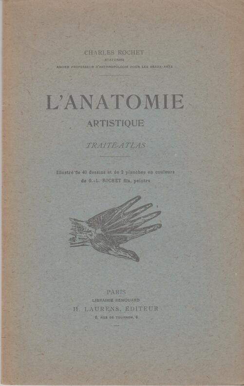
ROCHET (Charles)
L'ANATOMIE ARTISTIQUE : Traité-Atlas.
Paris : Librairie Renouard/H.Laurens, 1949. Plaquette brochée, 70 pages illustrée de 40 dessins en noir et 2 planches en couleurs de G.L.Tochet, peintre et fils de l'auteur, nomenclature anatomique en préambule. [BE, ouvrage non coupé, dos insolé]
Bookseller reference : SPN-1137
|
|
|
ROCHET Charles
L'Anatomie Artistique. Traité - Atlas.
Paris. Henri Laurens. 1949. Plaquette in-8. Br. illustrée de 40 dessins et de 2 planches en couleurs de Rochet G.-L. 72 p. Bon etat. Rousseurs sur la couv.
Bookseller reference : 35308
|
|
|
Rockland Atlas National Bank of Boston Hagemann H. Frederick Jr
"History Does Point the Way!" Rockland-Atlas National Bank of Boston 1833-1958
NY: Newcomen Society 1958. 2nd printing; stapled wraps; 28 pages. Paperback. Very Good. Illus. by B&w Illus. 8 vo. Newcomen Society Paperback
Bookseller reference : 059620

|
|
|
Rodney W. Shirley
Courtiers and Cannibals, Angels and Amazons: The Art of the Decorative Catographic Titlepage
Hes & de Graaf Publishers bv 2009 In-4 relié 29,2 cm sur 25. 272 pages. Très bon état d’occasion.
Bookseller reference : 72178
|
|
|
ROEBUCK W., ORME R.
L'ATLAS EN IMAGES
Nathan. 1989. In-4. Relié. Bon état, Couv. convenable, Dos abîmé, Intérieur acceptable. 60 pages. Illustré de nombreux dessins et de nombreuses cartes en couleur dans le texte.. . . . Classification Dewey : 912-Atlas, cartes et plans
Bookseller reference : RO60135924 ISBN : 2092105167
|
|
|
Roe, E. T.; Loomis, Elihu G.
BUSINESS AND LAW OR THE CAREFUL MAN'S GUIDE A Complete Legal and Business Compendium Including Facts, Figures, Tables, Weights, Measures, Statistics, Short Cuts in Figures, Etc. To Which is Added Practical Home Building and the Busy Man's Atlas
698 p. Illustrated. 8vo. Decorative edges. Original leather backed boards binding. Front joint starting. Would look handsome on a shelf. This old guides make wonderful gifts. PA 53
|
|
|
ROGERS ALISDAIR
ATLAS ILLUSTRE DU MONDE - POPULATIONS, LIEUX, NATURE, AGRICULTURE ET INDUSTRIES
KONEMANN. 2000. In-Folio. Relié. Bon état, Couv. convenable, Dos satisfaisant, Intérieur frais. 80 Pages. Nombreuses photos et illustrations en couleur dans et hors texte. Jaquette en bon état.. Avec Jaquette. . . Classification Dewey : 912-Atlas, cartes et plans
Bookseller reference : RO80185775
|
|
|
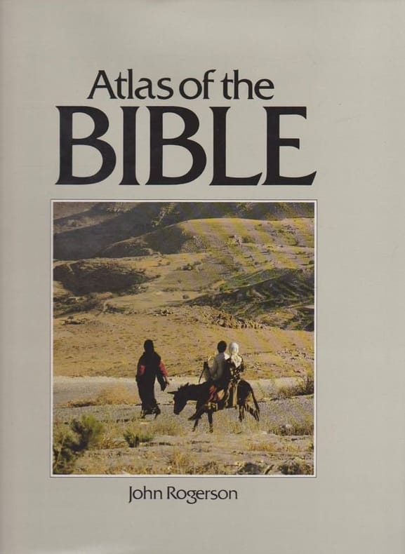
ROGERSON (John).
Atlas of the Bible.
London, Macdonald & Co, 1987, in-4°, 237 pp, 43 cartes en couleurs, 27 plans et schémas, 285 illustrations en couleurs et 67 en noir et blanc, avec légendes, chronologie, biblio, index, reliure percale bleue de l'éditeur, gardes illustrées, jaquette illustrée, bon état. Texte en anglais
Bookseller reference : 125216
|
|
|
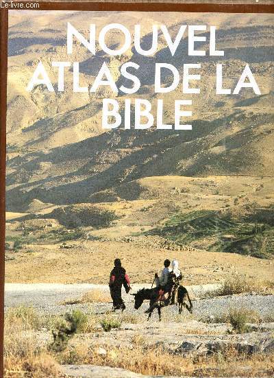
Rogerson John
Nouvel atlas de la bible.
Editions du Fanal. 1987. In-4. Relié. Bon état, Couv. convenable, Dos satisfaisant, Intérieur frais. 237 pages - jaquette en bon état - nombreuses photos et cartes en couleurs dans et hors texte.. Avec Jaquette. . . Classification Dewey : 912-Atlas, cartes et plans
Bookseller reference : R320144569
|
|
|
ROGERSON John
Nouvel atlas de la Bible.
Paris, Editions du Fanal, 1987 24 x 31, 236 pp., 27 plans et schémas, 43 cartes, plus de 350 illustrations dont 285 en couleurs, cartonnage éditeur + jaquette, très bon état
Bookseller reference : 12528
|
|
|
Rogerson J.
Nouvel Atlas de la Bible
Editions du Fanal Cartonné avec jaquette 1987 In-4 cartonnage de l'éditeur sous jaquette illustrée, 237 pp., nombreuses illustrations en couleurs in et hors-texte ; incidents minimes sur la jaquette, très bon état. Livraison a domicile (La Poste) ou en Mondial Relay sur simple demande.
Bookseller reference : dd540
|
|
|
ROGERSON John
Nouvel Atlas de la Bible
Editions du Fanal 1987 237 pages in-4. 1987. Cartonné/Jaquette. 237 pages. Nombreuses illustrations en noir et en couleurs
Bookseller reference : 16959
|
|
|
Roggeveen (Arent), Goos (Pieter)
The Burning Fen (The first part -The Second part)
Theatrum Orbis Terranum 1971 2 volumes. Grand in-4 toilé, sous jaquette illustrée. Nombreuses illustrations. facsimile atlas
Bookseller reference : 34206
|
|
|
Rogerson, John
Land der Bibel: Kunstgeschichte und Lebensformen.
Augsburg, Bechtermünz 1997. 4°. 237 S. reich illustriert, OPpbd., neuwertig.
Bookseller reference : KULT1176
|
|
|
Rohen, Johannes W., Chihiro Yokochi and Elke Lütjen-Drecoll
Color atlas of anatomy : a photographic study of the human body. ; Chihiro Yokochi ; Elke Lütjen-Drecoll 5. ed.
Stuttgart : Schattauer; Philadelphia ; Baltimore ; New York ; London ; Buenos Aires ; Hong Kong ; Sydney ; Tokyo : Lippincott, Williams and Wilkins 2002. XII, 500 S. : überw. Ill., graph. Darst. 30*23 cm. OPappband.
Bookseller reference : 124250

|
|
|
Rohmeder, [Wilhelm] / Wenz, Gustav
Methodischer Atlas : Ausgabe für Württemberg, Baden und die Hohenzollern'schen Lande : 25 Karten (incl. 8 Doppelblätter) in Farbendruck.
München, Druck und Verlag von R. Oldenbourg, 1886. 4° (33x27), 1 Bl., 33 Kartenblätter, Hldr d.Zt., Originalumschlag mit eingebunden, [2 Warenabbildungen] Rücken und Kanten bestossen, alter Name auf Innenspiegel, Fadenheftung etwas gelockert, Papier durchgehend etwas fleckig, ordentliches Belegexemplar,
Bookseller reference : 57341AB

|
|
|
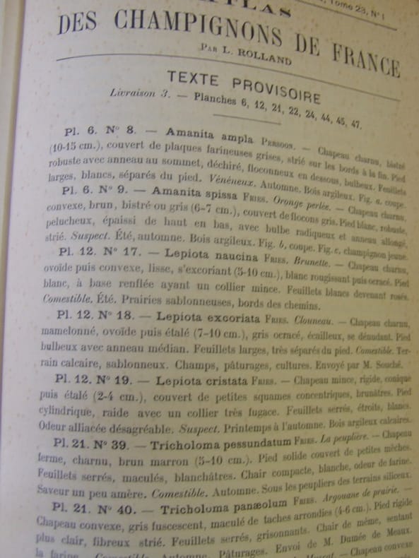
ROLLAND Léon
Atlas des champignons de France,Suisse et Belgique
grand in 8 demi-chagrin marron à nerfs,titre doré,double filet doré sur plats,Faux-titre,titre,126 pages de description,table des matières à la suite 120 planches en chromolithographie d’après les aquarelles de A.BESSIN entièrement montées sur onglets,représentant 283 espèces comestibles vénéneuses
Bookseller reference : 8032
|
|
|
ROLLIN.
Atlas de l’Histoire Ancienne de Rollin.
Sans lieu ni date (1860). Atlas in-4 (27x18cm), relié demi-chagrin et coins, dos à 6 nerfs, coins usés, 24pp de texte, 39 planches et 4 cartes dépliantes. COMPLET. Quelques rousseurs.
Bookseller reference : P1-3i-6
|
|
|
ROLLIN
ATLAS DE GEOGRAPHIE ANCIENNE, pour servir à l'intelligence des oeuvres de Rollin gravés d'après les cartes originales de d'Anville.
P, Carez, Thomine, Fortic , 1819 , in folio br , 2 p , 14 cartes et gravures à double page. Complet en soi. Contient les 14 planches de l' Histoire romaine.
Bookseller reference : M5626
|
|
|
ROLLAND Léon. BESSIN A.
Atlas des Champignons de France, Suisse et Belgique. - 120 planches coloriées représentant 283 espèces comestibles, vénéneuses ou remarquables par leur abondance ou leur forme, avec leur description et l'indication de leurs propriétés alimentaires. Aquarelles de A. BESSIN.
1910 Paris. Klincksieck. 1910. Gd et fort in-8 (165 x 250mm) dos chagrin noir à 5 nerfs (frotté), titre, filets et fleurons or, plats teinte jaspés, gardes jaspées, 126, (1) pages de texte et 120 planches couleurs montées sur onglets + Texte provisoire ; Supplements au Bull.de la Soc.Myc. de France tome 22 N°4.- 23 N°1,2,3,tome 24 N°2, tome 25 N°1,2,3, etc- rare état, bel exemplaire, bien relié,mais accident au milieu du dos.Remise de 20% pour toutes commandes égales ou supérieures à 100 €.
Bookseller reference : 27075
|
|
|
ROLAND, J. - DUCHESNE, E.
Atlas d’Histoire avec Tableaux-Résumés. Cours d’Histoire à l’usage de l’Enseignement moyen. Première Partie : Histoire Universelle jusqu’aux Croisades.
Namur, Ad. Wesmael-Charlier 1908, 275x215mm, 16pages, broché. Petite étiquette sur la page de couverture. Bel exemplaire.
Bookseller reference : 21164

|
|
|
ROLAND, J . & DUCHESNE, E .
Atlas-Manuel illustré de Géographie, avec le texte en regard des Cartes.
Namur, Ad. Wesmael-Charlier Editeur, 1905. grand in-8°, 66 pages, 32 cartes en couleurs, illustrations, agrafé, couv.
Bookseller reference : 41436
|
|
|
ROLLAND GEORGES
CARTE DE L'AFRIQUE FRANCAISE - en couleurs - Echelle 1/20000000e - de dimension 29 Cm 30 Cm environ / Conference de Garnison du 13 mars 1897.
NON PRECISE. 1897. In-Plano. En feuillets. Etat d'usage, Couv. convenable, Dos satisfaisant, Intérieur acceptable. 1 CARTE ENCOULEURS DE DIMENSION 29 Cm X 30 Cm ENVIRON. - Nombreuses rousseurs au dos de la carte sans conséquence sur la lecture.. . . . Classification Dewey : 912-Atlas, cartes et plans
Bookseller reference : R320059944
|
|
|
ROLAND (Dr F.), LAFRERY (Antoine)
Un franc-comtois éditeur et marchand d'estampes à Rome au xvie siècle : ANTOINE LAFRERY (1512-1577).
Besançon typographie et lithographie Dodivers 1911 un fascicule grand in-8°, couverture imprimée orange et titrée noire, 88 pp. Cinq planches en noir in fine. Non coupé.
Bookseller reference : 021795
|
|
|
ROLAND, J . & DUCHESNE, E .
Atlas-Manuel illustré de Géographie, avec le texte en regard des Cartes.
grand in-8°, 66 pages, 32 cartes en couleurs, illustrations, agrafé, couv. Tres bon etat. [PIL-5][PIL-5-]
|
|
|
Rolf, Anita (Redaktion)
Fahrrad Atlas. Die schönsten Radwanderungen in Deutschland. Touren, Technik, Fitness.
Ostfildern, Mairs Geographischer Verlag, 1991. Orig.-Pappband, 350 Seiten, Gr.-8°. Ganor / Thomae Sonderausgabe (1991). Die schönsten Radwanderungen in Deutschland. Sauberes und sehr gut erhaltenes Exemplar.
Bookseller reference : 006165

|
|
|
Rolf, Anita (Redaktion)
Sachs Fahrrad Atlas. Die schönsten Radwanderungen in Deutschland. Touren, Technik, Fitness.
Ostfildern, Mairs Geographischer Verlag, 1994. Orig.-Pappband, 446 Seiten, Gr.-8°. Die schönsten Radwanderungen in Deutschland. Sauberes und sehr gut erhaltenes Exemplar.
Bookseller reference : 006164

|
|
|
ROMAGNY, Charles.
Guerre Franco-Allemande 1870-1871. Atlas comprenant 18 cartes croquis en deux couleurs.
Paris, Limoges, Charles Lavauzelle,( 1891) ; porte-feuille petit in-folio de l'éditeur, demi-toile à coins ocre avec titre imprimé en noir au 1er plat , renfermant 18 cartes .Portefeuille un peu jauni.
Bookseller reference : cROU-283
|
|
|
ROMAGNESI Henri
Nouvel atlas des champignons, tome III.
Bordas Bordas, 1971, cartonnage éditeur sous jaquette, environ 29x22cm, bon état.
Bookseller reference : 114190
|
|
|
ROMAGNESI H.
Petit Atlas des Champignons. 2 vols.
Bordas.1971.2 vols in-12,cartonnage éditeur illustré en couleurs.Pages entières en couleurs de dessins de champignons.BE.Très légères piqùres sur les tranches.
Bookseller reference : 40576
|
|
|
Ron Atlas
Looking for Zebra: Hotel Zoo : Happy Hunting from A to Z
Little Simon. Hardcover. POOR. Noticeably used book. Heavy wear to cover. Pages contain marginal notes underlining and or highlighting. Possible ex library copy with all the markings/stickers of that library. Accessories such as CD codes toys and dust jackets may not be included. Little Simon hardcover
Bookseller reference : 3249843746 ISBN : 0671629239 9780671629236
|
|
|
Ron Atlas
Looking for Zebra: Hotel Zoo : Happy Hunting from A to Z
Very Good. Used book in very good condition. Some cover wear may contain a few marks. 100% guaranteed. 062720 unknown
Bookseller reference : 0671629239[vg] ISBN : 0671629239 9780671629236
|
|
|
Ron Atlas
Looking for Zebra: Hotel Zoo : Happy Hunting from A to Z
1986-04-02. Good. Ships with Tracking Number! INTERNATIONAL WORLDWIDE Shipping available. May not contain Access Codes or Supplements. May be re-issue. May be ex-library. Shipping & Handling by region. Buy with confidence excellent customer service! unknown
Bookseller reference : 0671629239 ISBN : 0671629239 9780671629236

|
|
|
Ron Atlas
Ten Pigs Fiddling
Amberwood Press 2006. Hardcover. Good. Disclaimer:A copy that has been read but remains in clean condition. All pages are intact and the cover is intact. The spine may show signs of wear. Pages can include limited notes and highlighting and the copy can include previous owner inscriptions. At ThriftBooks our motto is: Read More Spend Less.Dust jacket quality is not guaranteed. Amberwood Press hardcover
Bookseller reference : G0963024337I3N00 ISBN : 0963024337 9780963024336

|
|
|
Ron Atlas
Ten Pigs Fiddling
Amberwood Press 2006. Hardcover. Good. Disclaimer:A copy that has been read but remains in clean condition. All pages are intact and the cover is intact. The spine may show signs of wear. Pages can include limited notes and highlighting and the copy can include previous owner inscriptions. At ThriftBooks our motto is: Read More Spend Less.Dust jacket quality is not guaranteed. Amberwood Press hardcover
Bookseller reference : G0963024388I3N00 ISBN : 0963024388 9780963024381

|
|
|
Ron Atlas Stacie Flint Illustrator
Ten Pigs Fiddling
Amberwood Press 2005-09-15. Hardcover. Used:Good. Amberwood Press hardcover
Bookseller reference : DADAX0963024388 ISBN : 0963024388 9780963024381

|
|
|
Ron Atlas; Illustrator Stacie Flint
Ten Pigs Fiddling CD Edition
Amberwood Press Inc 2006-10-28. Hardcover. Good. Amberwood Press, Inc hardcover
Bookseller reference : SONG0963024337 ISBN : 0963024337 9780963024336

|
|
|
Ronald M Atlas
Many Faces Many Microbes: Personal Reflections in Microbiology
ASM Press 2000. This is an ex-library book and may have the usual library/used-book markings inside.This book has soft covers. In good all round condition. Please note the Image in this listing is a stock photo and may not match the covers of the actual item550grams ISBN:9781555811907 ASM Press paperback
Bookseller reference : 6502052 ISBN : 1555811906 9781555811907

|
|
|
Ronald M. Atlas
Basic and Practical Microbiology
Macmillan Pub Co 1986-01. Hardcover. Good. Macmillan Pub Co hardcover
Bookseller reference : SONG0023043504 ISBN : 0023043504 9780023043505
|
|
|
Ronald M. Atlas Jim Philp
Bioremediation: Applied Microbial Solutions for Real-World Environment Cleanup
Good. No Hassle 30 Day Returns Ships Daily Underlining/Highlighting: NONE Writing: None unknown
Bookseller reference : 6327621 ISBN : 1555812392 9781555812393

|
|
|
Ronald M. Atlas Editor Jim Philp Editor
Bioremediation: Applied Microbial Solutions for Real-World Environment Cleanup
Amer Society for Microbiology 2005-05-30. 1. Hardcover. Used:Good. Amer Society for Microbiology hardcover
Bookseller reference : DADAX1555812392 ISBN : 1555812392 9781555812393
|
|
|
Ronald M. Atlas
Customized Biology of Disease Bio 107 for Wright State University
Wright State. Used - Good. Shows some signs of wear and may have some markings on the inside. Wright State unknown
Bookseller reference : GRP83443929 ISBN : 069742278x 9780697422781
|
|
|
Ronald M. Atlas Alfred E. Brown Kenneth W. Dobra Llonas Miller
Experimental Microbiology Fundamentals And Applications
MacMillan Publishing Company. Used - Good. Shows some signs of wear and may have some markings on the inside. MacMillan Publishing Company unknown
Bookseller reference : GRP3307949 ISBN : 0023045302 9780023045301
|
|
 Receive by email
 Download as PDF document
 RSS feed


